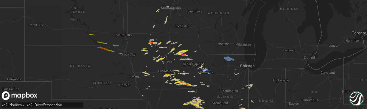
Hail Map on June 24, 2023
The weather event on June 24, 2023 includes Wind, Hail, and Tornado maps. 17 states and 572 cities were impacted and suffered possible damage. The total estimated number of properties impacted is 111,506.
Want more than just the map?
Turn this storm into a full workflow.
- Owner + property data so you know who to knock
- OnDemand branded weather history reports to win the "did we even have hail?" argument
- RoofTrace estimate so reps stop guessing numbers at the door
Bought this map? Upgrade within 7 days and we'll credit the $230. (10-15 min setup call)
Wind
Hail
Tornado
111,506
Estimated number of impacted properties by a 1.00" hail or larger56,754
Estimated number of impacted properties by a 1.75" hail or larger13,359
Estimated number of impacted properties by a 2.50" hail or largerStates Impacted by Hail Map on June 24, 2023
Storm reports
South Dakota
| Date | Description |
|---|---|
| 06/24/20236:55 PM CDT | In addition to hail up to the size of quarters for a few minutes... Some strong winds cut up the corn a bit... But 1.25 inch of rain was wonderful. |
| 06/24/20236:05 PM CDT | Social media photo of a heavily damaged barn and trees split 3.5 miles south of wakonda... Sd. |
| 06/24/20235:43 PM CDT | Photo of quarter sized hail in persons hand via social media. Time estimated from radar. |
| 06/24/20235:00 PM CDT | A local report indicates 1.25 inch wind near 6 SW Springfield |
| 06/24/20234:32 PM CDT | A local report indicates 1.25 inch wind near 6 NE Dante |
| 06/24/20234:22 PM CDT | Hail up to the size of walnuts and heavy rain. |
| 06/24/20234:10 PM CDT | Photo of large hail in persons hand via social media. Time estimated from radar. |
| 06/24/20234:00 PM CDT | A local report indicates 1.00 inch wind near Ravinia |
| 06/24/20233:57 PM CDT | A local report indicates 1.00 inch wind near 1 WNW Ravinia |
| 06/24/20233:53 PM CDT | A local report indicates 1.00 inch wind near 2 NE Lake Andes |
Nebraska
| Date | Description |
|---|---|
| 06/24/20236:27 PM CDT | A local report indicates 1.00 inch wind near 7 NE Coleridge |
| 06/24/20234:52 PM CDT | Lots of quarter to half dollar size hail at niobrara state park with wind gusts estimated at 45 mph. |
| 06/24/20234:42 PM CDT | Nickel to quarter size hail repoirted. |
Missouri
| Date | Description |
|---|---|
| 06/23/20238:40 PM CDT | Report 1 inch to 1.5 inch hail falling just north of hannibal proper. |
| 06/23/20238:30 PM CDT | Report via facebook of quarter sized hail in emden. |
| 06/23/20238:28 PM CDT | Reported quarter sized hail falling. |
| 06/23/20238:02 PM CDT | Pictures via twitter. Hail fell in lentner. |
| 06/23/20238:01 PM CDT | Via facebook. Delayed report. |
| 06/23/20237:46 PM CDT | Report of tree fallen on house... No significant damage. |
Illinois
| Date | Description |
|---|---|
| 06/24/20231:50 AM CDT | A tree and utility pole were blown down onto a car. Time estimated. |
| 06/24/20231:46 AM CDT | Photo shared on social media showed a tree 12 to 18 inches in diameter snapped. Time estimated. |
| 06/24/20231:46 AM CDT | A tree was reported down near 28th street and austin blvd. Time estimated by radar. |
| 06/24/202312:57 AM CDT | A photo shared on social media showed a large tree limb down on the hood of car causing damage near route 47 and green street. Time estimated. |
| 06/24/202312:38 AM CDT | Photo shared on social media of large tree branch... 6 to 10 inches in diameter... Snapped. Time estimated by radar. |
| 06/23/202311:56 PM CDT | Tree down in lee county at intersection of il 26 and todd road... Blocking traffic. |
| 06/23/202311:13 PM CDT | Report of a tree down. Time estimated by radar. |
| 06/23/202311:04 PM CDT | Peak wind gust of 56 kt; 64 mph... At krfd. |
| 06/23/202311:00 PM CDT | Estimated 60 to 65 mph winds. |
| 06/23/202310:57 PM CDT | Couple trees downed on hubbard road. Time estimated using radar. |
| 06/23/202310:25 PM CDT | 18-inch diameter tree downed at highland community college. Time estimated using radar. |
| 06/23/202310:24 PM CDT | County dispatch reported a few trees down north of freeport towards orangeville. There was also a report of a blown transformer in this area. Time estimated by radar. |
| 06/23/202310:16 PM CDT | Report of trees down... Along with a machine shed blown over. Time estimated by radar. |
| 06/23/20239:50 PM CDT | Trees down. |
| 06/23/20239:38 PM CDT | Caller reported 1 inch hail south of hull. |
| 06/23/20239:30 PM CDT | Trees down with power outages reported. |
| 06/23/20238:55 PM CDT | Widespread trees and power lines down. |
| 06/23/20238:02 PM CDT | Via twitter with picture included. Quarter shown in picture for scale. |
| 06/23/20237:59 PM CDT | Via twitter with picture included. Hail size estimated from picture. |
| 06/23/20237:56 PM CDT | Via twitter with picture included. Hail size estimated from picture. |
| 06/23/20237:56 PM CDT | Via twitter with picture included. Hail size estimated from picture. |
| 06/23/20237:56 PM CDT | Spotter reported a lot of hail with sizes varying from pea to 1 inch in diameter. |
| 06/23/20237:56 PM CDT | Via facebook with picture included. Quarter shown for scale. |
| 06/23/20237:52 PM CDT | A local report indicates 1.00 inch wind near 1 E Quincy |
| 06/23/20237:52 PM CDT | A local report indicates 1.75 inch wind near Quincy |
North Dakota
| Date | Description |
|---|---|
| 06/24/20236:25 PM CDT | Facebook picture. |
| 06/24/20236:18 PM CDT | Spotter called and reported quarter sized hail dropping and lightning 8 miles away. |
Minnesota
| Date | Description |
|---|---|
| 06/24/20235:30 PM CDT | Reported barn damage from tornado 47.309370... -95.933522. |
| 06/24/20234:59 PM CDT | Whitehill reports another touchdown near beltrami via nwschat. |
| 06/24/20234:57 PM CDT | H.anderson reports touchdown near flom. |
| 06/24/20234:52 PM CDT | Spotter mick elm called about 2 tornadoes forming from one with multiple vortices n. |
| 06/24/20234:52 PM CDT | Hunter anderson clalled about tornado with intermittent touchdowns near waubun. |
| 06/24/20234:38 PM CDT | Corrects previous tornado report from 2 ene mahnomen. Trees damaged. |
| 06/24/20234:37 PM CDT | S. Ebertowski from valley reports quarter size hail in mahnomen. |
| 06/24/20234:37 PM CDT | Valley news broadcaster reports quarter size hail in mahnomen. |
| 06/24/20234:30 PM CDT | Corrects previous tornado report from 2 ese mahnomen. Reported barn damage from tornado 47.314827... -95.931726. |
| 06/24/20234:25 PM CDT | Tornado confirmed near lockhart and went through tree grove norman em was going to survey for damage. |
| 06/24/20234:15 PM CDT | Norman em reported touchdown near shelly heading n-nw. |
| 06/24/20234:05 PM CDT | Tornado touchdown near borup. |
| 06/24/20234:00 PM CDT | Trees damaged. |
| 06/24/20233:59 PM CDT | Public confirms tornado with picture via twitter. |
| 06/24/20233:57 PM CDT | Corrects previous tornado report from 3 s flom. Hunter anderson reports touchdown near flom. |
| 06/24/20233:30 PM CDT | Spotter confirms tornado near ada with picture via twitter. |
| 06/24/20233:20 PM CDT | Dillon vogt from wday sent us photos of tornado still moving. |
| 06/24/20233:20 PM CDT | Wday broadcaster sent us photos of tornado still moving. |
| 06/24/20233:20 PM CDT | Met sent us tornado picture via twitter 6 w of callaway. |
| 06/23/20239:28 PM CDT | Hail for up to 30 minutes. Mostly around a half inch in size... But a few were up to the size of quarters. Time estimated from radar. |
| 06/23/20238:32 PM CDT | A local report indicates 1.00 inch wind near Biscay |
Texas
| Date | Description |
|---|---|
| 06/23/202310:15 PM CDT | A local report indicates 60 MPH wind near 3 NE Knickerbocker |
| 06/23/20239:32 PM CDT | West texas mesonet site at san angelo 7nw measured gust to 68 mph. |
| 06/23/20239:30 PM CDT | Tin roof ripped off residential home in robert lee. |
| 06/23/20239:27 PM CDT | Report from facebook. 10-15 minutes of hail in buffalo heights with very strong winds. |
| 06/23/20239:00 PM CDT | 60 mph winds along with several tree branches broken. |
| 06/23/20238:54 PM CDT | Report from mping: 1-inch tree limbs broken; shingles blown off. |
| 06/23/20238:50 PM CDT | Power poles down in the city of tye. Time estimated on radar. |
| 06/23/20238:50 PM CDT | Power lines down near hamby. Time estimated on radar. |
| 06/23/20238:35 PM CDT | Power lines down in the city of merkel. Time estimated on radar. |
| 06/23/20238:10 PM CDT | A local report indicates 75 MPH wind near 4 N Merkel |
Iowa
| Date | Description |
|---|---|
| 06/24/20236:58 PM CDT | Couple trees downed and some siding damage. Time estimated using radar. |
| 06/24/20236:25 PM CDT | A local report indicates 1.25 inch wind near 3 NW Kilbourn |
| 06/24/20236:17 PM CDT | Report from mping. |
| 06/24/20236:15 PM CDT | Report from mping. |
| 06/24/20236:10 PM CDT | Report/video from twitter... Hail of quarter to half dollar size. |
| 06/24/20235:57 PM CDT | Report from mping: quarter |
| 06/24/20235:38 PM CDT | 1 tree down and 1 large branch down near vicinity of 1st st nw... 2nd ave nw... And charles st w. |
| 06/24/20235:26 PM CDT | A local report indicates 1.00 inch wind near 1 S Ottumwa |
| 06/24/20235:25 PM CDT | A local report indicates 2.50 inch wind near 3 SSE Ottumwa |
| 06/24/20235:25 PM CDT | (dmx |
| 06/24/20235:23 PM CDT | Social media report of multiple large branches downed on road 2 miles west of marne. |
| 06/24/20235:22 PM CDT | Report from mping: quarter |
| 06/24/20235:20 PM CDT | A local report indicates 1.00 inch wind near 3 SW Westgate |
| 06/24/20235:16 PM CDT | Quarter size hail. |
| 06/24/20235:16 PM CDT | Via spotternetwork.org. |
| 06/24/20235:13 PM CDT | Power lines down and debris along boston rd. Delayed report. |
| 06/24/20235:08 PM CDT | Report from mping: quarter |
| 06/24/20235:04 PM CDT | A local report indicates 1.00 inch wind near 1 E Blakesburg |
| 06/24/20235:02 PM CDT | At least quarter sized hail. Flag pole snapped in front yard. |
| 06/24/20234:59 PM CDT | Report from mping: quarter |
| 06/24/20234:55 PM CDT | Report from mping: quarter |
| 06/24/20234:44 PM CDT | Tree uprooted and damaged along waverly rd. Gazebo damaged. From kwwl tv. Time estimated by radar. |
| 06/24/20234:00 PM CDT | Largest stone were quarter sized. |
| 06/24/20232:31 PM CDT | Delayed report with time estimated. Via kcci viewer. |
| 06/24/20232:30 PM CDT | Relayed from nwschat. |
| 06/24/20239:06 AM CDT | Tree branch fell on car parked in street. Report relayed by who media via social media. Time estimated by radar. |
| 06/24/20231:03 AM CDT | Report from mping: golf ball |
| 06/24/20231:00 AM CDT | A local report indicates 1.25 inch wind near Elk Run Heights |
| 06/24/20231:00 AM CDT | Forwarded by kwwl tv. |
| 06/24/20231:00 AM CDT | Shredded leaves from hail. Delayed report. |
| 06/24/202312:55 AM CDT | From kwwl tv viewer. |
| 06/24/202312:55 AM CDT | A local report indicates 3.00 inch wind near 1 SW Evansdale |
| 06/24/202312:52 AM CDT | A local report indicates 1.75 inch wind near 2 SW Waterloo |
| 06/24/202312:50 AM CDT | A local report indicates 1.50 inch wind near Waterloo |
| 06/24/202312:49 AM CDT | Trained spotter reports measured 1.5 inch diameter hail in cedar falls. |
| 06/24/202312:48 AM CDT | Report from mping: golf ball |
| 06/24/202312:45 AM CDT | Minor leaf damage... Shredded leaves. |
| 06/24/202312:09 AM CDT | Trees down in bettendorf. |
| 06/23/202311:15 PM CDT | Large tree branch downed in swea city. Time estimated by radar. |
| 06/23/202311:04 PM CDT | Golf ball size hail intermixed with quarter sized hail now north of cylinder. |
| 06/23/202311:00 PM CDT | Reported by trained spotter. |
| 06/23/202311:00 PM CDT | Media relayed report of measured 3 inch stone west of cylinder. Delayed report. Time and location estimated from radar. |
| 06/23/202310:55 PM CDT | Leaf damage to trees around town. Some branches downed as well. Delayed report. |
| 06/23/202310:55 PM CDT | Law enforcement relayed a report of nearly baseball sized hail in emmetsburg. Delayed report. Time estimated. |
| 06/23/202310:52 PM CDT | Law enforcement reports golf ball sized hail falling in emmetsburg. |
| 06/23/202310:40 PM CDT | Asos. |
| 06/23/202310:31 PM CDT | A tornado developed about 2 miles east of walcott along interstate 80. The tornado tracked east and caused sporadic minor tree and structure damage at the northwest bou |
| 06/23/202310:18 PM CDT | Report of tree limbs down in durant. A tree was blown over onto a homes roof. . |
| 06/23/202310:18 PM CDT | Trees down across roads. Also baseball diamond fence damaged. |
| 06/23/202310:15 PM CDT | Trees down across roads. |
| 06/23/20239:28 PM CDT | Numerous small branches downed. Time estimated using radar. |
| 06/23/20239:28 PM CDT | Public report from east of algona on highway 18. Location estimated from radar. |
| 06/23/20239:20 PM CDT | Delayed report via social media. |
| 06/23/20238:53 PM CDT | Sheriffs office reported trees and powerlines down around the city. |
| 06/23/20238:53 PM CDT | Sheriffs office reported trees and powerlines down in the city of dubuque. |
| 06/23/20238:41 PM CDT | Large tree fell across highway 3. |
| 06/23/20238:06 PM CDT | Large tree limb down. |
| 06/23/20237:37 PM CDT | A local report indicates 1.00 inch wind near 3 ESE Lowell |
| 06/23/20237:37 PM CDT | 4 to 5 inch tree limbs down along with lots of small branches. |
Wisconsin
| Date | Description |
|---|---|
| 06/23/20238:39 PM CDT | A few trees and large limbs downed. |
Cities Impacted by Hail Map on June 24, 2023
- Lake Benton, MN
- Holland, MN
- Ruthton, MN
- Balaton, MN
- Tyler, MN
- Arco, MN
- Russell, MN
- Pipestone, MN
- Taunton, MN
- Minneota, MN
- Lynd, MN
- Ivanhoe, MN
- Marshall, MN
- Ghent, MN
- Woodstock, MN
- Paton, IA
- Harcourt, IA
- Ogden, IA
- Dayton, IA
- Stratford, IA
- Pilot Mound, IA
- Boxholm, IA
- New Market, IA
- Nemaha, IA
- Madrid, IA
- Boone, IA
- Humboldt, IA
- Liscomb, IA
- Albion, IA
- Conrad, IA
- Audubon, IA
- Manning, IA
- Bedford, IA
- Clarinda, IA
- Gravity, IA
- Blairsburg, IA
- Jefferson, IA
- Dana, IA
- Grand Junction, IA
- Mount Vernon, MO
- Miller, MO
- Lehigh, IA
- Otho, IA
- Storm Lake, IA
- Early, IA
- Newell, IA
- Sac City, IA
- Braddyville, IA
- Ellsworth, IA
- Craig, MO
- Mound City, MO
- Clare, IA
- Dakota City, IA
- North Port, FL
- Farnhamville, IA
- Lakeland, FL
- Ackworth, IA
- Milo, IA
- Stanhope, IA
- Indianola, IA
- Fort Pierce, FL
- Knoxville, IA
- Pleasantville, IA
- Lake Park, MN
- Hampton, IA
- Lake Andes, SD
- Wagner, SD
- Spencer, NE
- Bristow, NE
- Lynch, NE
- Parkersburg, IA
- New Hartford, IA
- Albia, IA
- Shell Rock, IA
- Cedar Falls, IA
- Janesville, IA
- Waverly, IA
- Ada, MN
- Avon, SD
- Niobrara, NE
- Moravia, IA
- Blakesburg, IA
- Ottumwa, IA
- Springfield, SD
- Denver, IA
- Waterloo, IA
- Readlyn, IA
- Dunkerton, IA
- Walnut, IA
- Avoca, IA
- Marne, IA
- Atlantic, IA
- Agency, IA
- Eldon, IA
- Bloomfield, IA
- Floris, IA
- Fairbank, IA
- Oran, IA
- Oelwein, IA
- Dumont, IA
- Aredale, IA
- Platte, SD
- Chamberlain, SD
- Kimball, SD
- Utica, SD
- Yankton, SD
- Mission Hill, SD
- Volin, SD
- Bloomfield, NE
- Crofton, NE
- Hartington, NE
- Vermillion, SD
- Sumner, IA
- Westgate, IA
- Selma, IA
- Douds, IA
- Keosauqua, IA
- Birmingham, IA
- Bonaparte, IA
- Stockport, IA
- Mayville, ND
- Portland, ND
- Mahnomen, MN
- New Prague, MN
- Badger, IA
- Roseland, LA
- Kilkenny, MN
- Chariton, IA
- Maringouin, LA
- Grosse Tete, LA
- Elysian, MN
- Edgard, LA
- Wellsburg, IA
- Waterville, MN
- Janesville, MN
- Gowrie, IA
- Jonesville, LA
- Lohrville, IA
- Lovilia, IA
- Alden, IA
- Bejou, MN
- Picayune, MS
- Carriere, MS
- Geneva, IA
- Baton Rouge, LA
- Columbia, IA
- Melcher Dallas, IA
- Baker, LA
- Harrisonburg, LA
- Steamboat Rock, IA
- Ackley, IA
- Zachary, LA
- Port Allen, LA
- Sicily Island, LA
- Montgomery, MN
- Elk Horn, IA
- Fosston, MN
- Waubun, MN
- Mystic, IA
- Rockwell City, IA
- Port Saint Lucie, FL
- Prole, IA
- Saint Charles, IA
- Saint Marys, IA
- Otley, IA
- Pella, IA
- Woodburn, IA
- Lucas, IA
- Osceola, IA
- Hingham, MT
- Loxahatchee, FL
- Mason City, IA
- Rockwell, IA
- Callender, IA
- Churdan, IA
- Duncombe, IA
- Fort Dodge, IA
- New Virginia, IA
- Naples, FL
- Truro, IA
- Belle Glade, FL
- Jewell, IA
- Melrose, IA
- Russell, IA
- Hamilton, IA
- Sheffield, IA
- Bradford, IA
- Iowa Falls, IA
- Everton, MO
- Ash Grove, MO
- Denham Springs, LA
- Sebeka, MN
- Menahga, MN
- Hillsboro, IA
- Donnellson, IA
- West Point, IA
- Saint Paul, IA
- Palmyra, MO
- Taylor, MO
- Maywood, MO
- Quincy, IL
- Liberty, IL
- Payson, IL
- Fowler, IL
- Plainville, IL
- Clarence, MO
- Lentner, MO
- Shelbina, MO
- Shelbyville, MO
- Hunnewell, MO
- Emden, MO
- Nevis, MN
- Akeley, MN
- Hannibal, MO
- Hull, IL
- Monroe City, MO
- Philadelphia, MO
- Merkel, TX
- Hawley, TX
- Abilene, TX
- Tye, TX
- Mertzon, TX
- Brownton, MN
- Glencoe, MN
- Hutchinson, MN
- Silver Lake, MN
- Kahoka, MO
- San Angelo, TX
- Wayland, MO
- Trent, TX
- New London, MO
- Kinderhook, IL
- Algona, IA
- Wesley, IA
- Carlsbad, TX
- New Canton, IL
- Rockport, IL
- Alta, IA
- Truesdale, IA
- Rembrandt, IA
- Pleasant Hill, IL
- Wilton, IA
- Durant, IA
- New Liberty, IA
- Walcott, IA
- Stockton, IA
- Davenport, IA
- Ruthven, IA
- Emmetsburg, IA
- Eldridge, IA
- Bettendorf, IA
- Pleasant Valley, IA
- Cylinder, IA
- Pecatonica, IL
- Winnebago, IL
- Rockford, IL
- Machesney Park, IL
- Loves Park, IL
- Byron, IL
- Stillman Valley, IL
- Davis Junction, IL
- Cherry Valley, IL
- Belvidere, IL
- Kirkland, IL
- Monroe Center, IL
- Poplar Grove, IL
- Caledonia, IL
- Marengo, IL
- Genoa, IL
- Garden Prairie, IL
- Ursa, IL
- Mount Hermon, LA
- New Sharon, IA
- Mallard, IA
- Fontanelle, IA
- La Porte City, IA
- Dysart, IA
- Bagley, MN
- Ely, IA
- Whittemore, IA
- West Bend, IA
- Center Point, IA
- Mount Auburn, IA
- Central City, IA
- Vinton, IA
- Urbana, IA
- Walker, IA
- Nora Springs, IA
- Rudd, IA
- Floyd, IA
- Luray, MO
- Arbela, MO
- Gorin, MO
- Wyaconda, MO
- Lynnville, IA
- Grinnell, IA
- Sully, IA
- Ballinger, TX
- Rowena, TX
- Strawberry Point, IA
- Edgewood, IA
- Manchester, IA
- Searsboro, IA
- Ironwood, MI
- Bessemer, MI
- Amite, LA
- Miles, TX
- Lacona, IA
- La Grange, MO
- Lewistown, MO
- Monticello, MO
- Clinton, LA
- McCamey, TX
- Iraan, TX
- Midkiff, TX
- Ozona, TX
- Reasnor, IA
- Montezuma, IA
- Big Lake, TX
- Canton, MO
- Wiota, IA
- Lewis, IA
- Graettinger, IA
- Nashua, IA
- Greene, IA
- Charles City, IA
- Curlew, IA
- Britt, IA
- Drakesville, IA
- Baylis, IL
- Motley, MN
- Clarksville, IA
- Ionia, IA
- Tylertown, MS
- Fenton, IA
- Cumberland, IA
- Ayrshire, IA
- Anabel, MO
- Osyka, MS
- Franklinton, LA
- Mccomb, MS
- Dyess Afb, TX
- Keswick, IA
- Gibson, IA
- What Cheer, IA
- Barnes City, IA
- Rose Hill, IA
- Aurelia, IA
- Park Rapids, MN
- Fort Madison, IA
- Kentwood, LA
- Newton, IA
- Killduff, IA
- Bogalusa, LA
- Deep River, IA
- Batavia, IA
- Unionville, IA
- Centreville, MS
- Traer, IA
- Pilot Rock, OR
- Eddyville, IA
- Camp Point, IL
- Ewing, MO
- Durham, MO
- Ashburn, MO
- Clayton, IL
- Barry, IL
- Libertyville, IA
- Farmington, IA
- Denmark, IA
- Wever, IA
- Evansdale, IA
- Raymond, IA
- Jesup, IA
- Plano, IL
- Yorkville, IL
- Aplington, IA
- Alexander, IA
- Kanawha, IA
- Corwith, IA
- Latimer, IA
- Belmond, IA
- Lu Verne, IA
- Dike, IA
- Laurel, NE
- Dixon, NE
- Newcastle, NE
- Little Falls, MN
- Sherburn, MN
- Dunnell, MN
- Coal Valley, IL
- Weldon, IA
- Brainerd, MN
- Dickens, IA
- Pequot Lakes, MN
- Goldfield, IA
- Renwick, IA
- Griggsville, IL
- Chambersburg, IL
- Lost Nation, IA
- Pine River, MN
- Albert City, IA
- Lowden, IA
- Clarence, IA
- Bennett, IA
- Tipton, IA
- Gilbertville, IA
- Throckmorton, TX
- Cedar Rapids, IA
- Palo, IA
- Hamel, MN
- Plano, IA
- Nebo, IL
- Garner, IA
- Burkett, TX
- Gladstone, IL
- Fort Ripley, MN
- Ainsworth, IA
- Crawfordsville, IA
- Lester Prairie, MN
- Humeston, IA
- West Liberty, IA
- Muscatine, IA
- Nichols, IA
- Ringsted, IA
- Wallingford, IA
- Moline, IL
- Cross Plains, TX
- Corydon, IA
- Lone Rock, IA
- Kampsville, IL
- Versailles, IL
- Havelock, IA
- Garrison, IA
- Reinbeck, IA
- Udell, IA
- Centerville, IA
- Timewell, IL
- Pillager, MN
- Baxter, MN
- Coatsburg, IL
- Paloma, IL
- Mendon, IL
- Ventura, IA
- Clear Lake, IA
- Louisiana, MO
- Marion, IA
- Lewisville, MN
- Saint James, MN
- Madelia, MN
- Sigourney, IA
- Webster, IA
- South English, IA
- Streator, IL
- Delta, IA
- Stamford, TX
- Stout, IA
- Solon, IA
- Montrose, IL
- Greenup, IL
- Jewett, IL
- Toledo, IL
- Sperry, IA
- Burlington, IA
- Derby, IA
- Donahue, IA
- Long Grove, IA
- Dixon, IA
- Baird, TX
- Oxford Junction, IA
- Wheatland, IA
- Anson, TX
- Sudan, TX
- Holland, IA
- Livermore, IA
- Hardy, IA
- Minneapolis, MN
- Wayzata, MN
- Norwood, LA
- Argyle, IA
- Keota, IA
- Pearl, IL
- Clarksville, MO
- Frankford, MO
- Rockford, IA
- Hudson, IA
- West Branch, IA
- Backus, MN
- Verona, IL
- Morris, IL
- Lerna, IL
- Bancroft, IA
- Hidalgo, IL
- Bruceville, IN
- Bicknell, IN
- Oaktown, IN
- Leitchfield, KY
- Ashmore, IL
- Casey, IL
- Westfield, IL
- Marshall, IL
- Martinsville, IL
- Kansas, IL
- Robinson, IL
- Hutsonville, IL
- Palestine, IL
- Kentland, IN
- Huntingburg, IN
- Ferdinand, IN
- Holland, IN
- Dale, IN
- Avon, IL
- Berwick, IL
- Marshall, IN
- Rockville, IN
- Oquawka, IL
- Goodland, IN
- Newton, IL
- Yale, IL
- Flat Rock, IL
- Clay City, IN
- Charleston, IL
- Willow Hill, IL
- Kirkwood, IL
- Biggsville, IL
- Stronghurst, IL
- Media, IL
- Smithshire, IL
- Sheldon, IL
- Watseka, IL
- Roseville, IL
- Saint Augustine, IL
- Minooka, IL
- Campbellsburg, IN
- Irvington, KY
- Oblong, IL
- Buckley, IL
- Cissna Park, IL
- Onarga, IL
- Bloomingdale, IN
- Kingman, IN
- Terre Haute, IN
- Lewis, IN
- Coal City, IN
- Carlisle, IN
- Lawrenceville, IL
- Sumner, IL
- Paris, IL
- Caneyville, KY
- Gays, IL
- Farmersburg, IN
- Shelburn, IN
- Pimento, IN
- Neoga, IL
- Trilla, IL
- Broadlands, IL
- Homer, IL
- Sidney, IL
- Dubois, IN
- Earl Park, IN
- Brook, IN
- Fowler, IN
- Albion, IL
- Crescent City, IL
- Hindsboro, IL
- Oakland, IL
- Independence, IA
- Nisswa, MN
- Milford, IL
- Wheatland, IN
- Celestine, IN
- Washington, IN