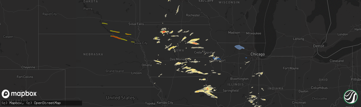
Hail Map in Iowa on June 24, 2023
The weather event in Iowa on June 24, 2023 includes Wind, Hail, and Tornado maps. 17 states and 572 cities were impacted and suffered possible damage. The total estimated number of properties impacted is 72,472.
Want more than just the map?
Turn this storm into a full workflow.
- Owner + property data so you know who to knock
- OnDemand branded weather history reports to win the "did we even have hail?" argument
- RoofTrace estimate so reps stop guessing numbers at the door
Bought this map? Upgrade within 7 days and we'll credit the $230. (10-15 min setup call)
Wind
Hail
Tornado
72,472
Estimated number of impacted properties by a 1.00" hail or larger27,739
Estimated number of impacted properties by a 1.75" hail or larger13,359
Estimated number of impacted properties by a 2.50" hail or largerStorm reports in Iowa
Iowa
| Date | Description |
|---|---|
| 06/24/20236:58 PM CDT | Couple trees downed and some siding damage. Time estimated using radar. |
| 06/24/20236:25 PM CDT | A local report indicates 1.25 inch wind near 3 NW Kilbourn |
| 06/24/20236:17 PM CDT | Report from mping. |
| 06/24/20236:15 PM CDT | Report from mping. |
| 06/24/20236:10 PM CDT | Report/video from twitter... Hail of quarter to half dollar size. |
| 06/24/20235:57 PM CDT | Report from mping: quarter |
| 06/24/20235:38 PM CDT | 1 tree down and 1 large branch down near vicinity of 1st st nw... 2nd ave nw... And charles st w. |
| 06/24/20235:26 PM CDT | A local report indicates 1.00 inch wind near 1 S Ottumwa |
| 06/24/20235:25 PM CDT | A local report indicates 2.50 inch wind near 3 SSE Ottumwa |
| 06/24/20235:25 PM CDT | (dmx |
| 06/24/20235:23 PM CDT | Social media report of multiple large branches downed on road 2 miles west of marne. |
| 06/24/20235:22 PM CDT | Report from mping: quarter |
| 06/24/20235:20 PM CDT | A local report indicates 1.00 inch wind near 3 SW Westgate |
| 06/24/20235:16 PM CDT | Via spotternetwork.org. |
| 06/24/20235:16 PM CDT | Quarter size hail. |
| 06/24/20235:13 PM CDT | Power lines down and debris along boston rd. Delayed report. |
| 06/24/20235:08 PM CDT | Report from mping: quarter |
| 06/24/20235:04 PM CDT | A local report indicates 1.00 inch wind near 1 E Blakesburg |
| 06/24/20235:02 PM CDT | At least quarter sized hail. Flag pole snapped in front yard. |
| 06/24/20234:59 PM CDT | Report from mping: quarter |
| 06/24/20234:55 PM CDT | Report from mping: quarter |
| 06/24/20234:44 PM CDT | Tree uprooted and damaged along waverly rd. Gazebo damaged. From kwwl tv. Time estimated by radar. |
| 06/24/20234:00 PM CDT | Largest stone were quarter sized. |
| 06/24/20232:31 PM CDT | Delayed report with time estimated. Via kcci viewer. |
| 06/24/20232:30 PM CDT | Relayed from nwschat. |
| 06/24/20239:06 AM CDT | Tree branch fell on car parked in street. Report relayed by who media via social media. Time estimated by radar. |
| 06/24/20231:03 AM CDT | Report from mping: golf ball |
| 06/24/20231:00 AM CDT | A local report indicates 1.25 inch wind near Elk Run Heights |
| 06/24/20231:00 AM CDT | Shredded leaves from hail. Delayed report. |
| 06/24/20231:00 AM CDT | Forwarded by kwwl tv. |
| 06/24/202312:55 AM CDT | From kwwl tv viewer. |
| 06/24/202312:55 AM CDT | A local report indicates 3.00 inch wind near 1 SW Evansdale |
| 06/24/202312:52 AM CDT | A local report indicates 1.75 inch wind near 2 SW Waterloo |
| 06/24/202312:50 AM CDT | A local report indicates 1.50 inch wind near Waterloo |
| 06/24/202312:49 AM CDT | Trained spotter reports measured 1.5 inch diameter hail in cedar falls. |
| 06/24/202312:48 AM CDT | Report from mping: golf ball |
| 06/24/202312:45 AM CDT | Minor leaf damage... Shredded leaves. |
| 06/24/202312:09 AM CDT | Trees down in bettendorf. |
| 06/23/202311:15 PM CDT | Large tree branch downed in swea city. Time estimated by radar. |
| 06/23/202311:04 PM CDT | Golf ball size hail intermixed with quarter sized hail now north of cylinder. |
| 06/23/202311:00 PM CDT | Reported by trained spotter. |
| 06/23/202311:00 PM CDT | Media relayed report of measured 3 inch stone west of cylinder. Delayed report. Time and location estimated from radar. |
| 06/23/202310:55 PM CDT | Law enforcement relayed a report of nearly baseball sized hail in emmetsburg. Delayed report. Time estimated. |
| 06/23/202310:55 PM CDT | Leaf damage to trees around town. Some branches downed as well. Delayed report. |
| 06/23/202310:52 PM CDT | Law enforcement reports golf ball sized hail falling in emmetsburg. |
| 06/23/202310:40 PM CDT | Asos. |
| 06/23/202310:31 PM CDT | A tornado developed about 2 miles east of walcott along interstate 80. The tornado tracked east and caused sporadic minor tree and structure damage at the northwest bou |
| 06/23/202310:18 PM CDT | Report of tree limbs down in durant. A tree was blown over onto a homes roof. . |
| 06/23/202310:18 PM CDT | Trees down across roads. Also baseball diamond fence damaged. |
| 06/23/202310:15 PM CDT | Trees down across roads. |
| 06/23/20239:28 PM CDT | Public report from east of algona on highway 18. Location estimated from radar. |
| 06/23/20239:28 PM CDT | Numerous small branches downed. Time estimated using radar. |
| 06/23/20239:20 PM CDT | Delayed report via social media. |
| 06/23/20238:53 PM CDT | Sheriffs office reported trees and powerlines down in the city of dubuque. |
| 06/23/20238:53 PM CDT | Sheriffs office reported trees and powerlines down around the city. |
| 06/23/20238:41 PM CDT | Large tree fell across highway 3. |
| 06/23/20238:06 PM CDT | Large tree limb down. |
| 06/23/20237:37 PM CDT | 4 to 5 inch tree limbs down along with lots of small branches. |
| 06/23/20237:37 PM CDT | A local report indicates 1.00 inch wind near 3 ESE Lowell |
All States Impacted by Hail Map on June 24, 2023
Cities Impacted by Hail Map on June 24, 2023
- Lake Benton, MN
- Holland, MN
- Ruthton, MN
- Balaton, MN
- Tyler, MN
- Arco, MN
- Russell, MN
- Pipestone, MN
- Taunton, MN
- Minneota, MN
- Lynd, MN
- Ivanhoe, MN
- Marshall, MN
- Ghent, MN
- Woodstock, MN
- Paton, IA
- Harcourt, IA
- Ogden, IA
- Dayton, IA
- Stratford, IA
- Pilot Mound, IA
- Boxholm, IA
- New Market, IA
- Nemaha, IA
- Madrid, IA
- Boone, IA
- Humboldt, IA
- Liscomb, IA
- Albion, IA
- Conrad, IA
- Audubon, IA
- Manning, IA
- Bedford, IA
- Clarinda, IA
- Gravity, IA
- Blairsburg, IA
- Jefferson, IA
- Dana, IA
- Grand Junction, IA
- Mount Vernon, MO
- Miller, MO
- Lehigh, IA
- Otho, IA
- Storm Lake, IA
- Early, IA
- Newell, IA
- Sac City, IA
- Braddyville, IA
- Ellsworth, IA
- Craig, MO
- Mound City, MO
- Clare, IA
- Dakota City, IA
- North Port, FL
- Farnhamville, IA
- Lakeland, FL
- Ackworth, IA
- Milo, IA
- Stanhope, IA
- Indianola, IA
- Fort Pierce, FL
- Knoxville, IA
- Pleasantville, IA
- Lake Park, MN
- Hampton, IA
- Lake Andes, SD
- Wagner, SD
- Spencer, NE
- Bristow, NE
- Lynch, NE
- Parkersburg, IA
- New Hartford, IA
- Albia, IA
- Shell Rock, IA
- Cedar Falls, IA
- Janesville, IA
- Waverly, IA
- Ada, MN
- Avon, SD
- Niobrara, NE
- Moravia, IA
- Blakesburg, IA
- Ottumwa, IA
- Springfield, SD
- Denver, IA
- Waterloo, IA
- Readlyn, IA
- Dunkerton, IA
- Walnut, IA
- Avoca, IA
- Marne, IA
- Atlantic, IA
- Agency, IA
- Eldon, IA
- Bloomfield, IA
- Floris, IA
- Fairbank, IA
- Oran, IA
- Oelwein, IA
- Dumont, IA
- Aredale, IA
- Platte, SD
- Chamberlain, SD
- Kimball, SD
- Utica, SD
- Yankton, SD
- Mission Hill, SD
- Volin, SD
- Bloomfield, NE
- Crofton, NE
- Hartington, NE
- Vermillion, SD
- Sumner, IA
- Westgate, IA
- Selma, IA
- Douds, IA
- Keosauqua, IA
- Birmingham, IA
- Bonaparte, IA
- Stockport, IA
- Mayville, ND
- Portland, ND
- Mahnomen, MN
- New Prague, MN
- Badger, IA
- Roseland, LA
- Kilkenny, MN
- Chariton, IA
- Maringouin, LA
- Grosse Tete, LA
- Elysian, MN
- Edgard, LA
- Wellsburg, IA
- Waterville, MN
- Janesville, MN
- Gowrie, IA
- Jonesville, LA
- Lohrville, IA
- Lovilia, IA
- Alden, IA
- Bejou, MN
- Picayune, MS
- Carriere, MS
- Geneva, IA
- Baton Rouge, LA
- Columbia, IA
- Melcher Dallas, IA
- Baker, LA
- Harrisonburg, LA
- Steamboat Rock, IA
- Ackley, IA
- Zachary, LA
- Port Allen, LA
- Sicily Island, LA
- Montgomery, MN
- Elk Horn, IA
- Fosston, MN
- Waubun, MN
- Mystic, IA
- Rockwell City, IA
- Port Saint Lucie, FL
- Prole, IA
- Saint Charles, IA
- Saint Marys, IA
- Otley, IA
- Pella, IA
- Woodburn, IA
- Lucas, IA
- Osceola, IA
- Hingham, MT
- Loxahatchee, FL
- Mason City, IA
- Rockwell, IA
- Callender, IA
- Churdan, IA
- Duncombe, IA
- Fort Dodge, IA
- New Virginia, IA
- Naples, FL
- Truro, IA
- Belle Glade, FL
- Jewell, IA
- Melrose, IA
- Russell, IA
- Hamilton, IA
- Sheffield, IA
- Bradford, IA
- Iowa Falls, IA
- Everton, MO
- Ash Grove, MO
- Denham Springs, LA
- Sebeka, MN
- Menahga, MN
- Hillsboro, IA
- Donnellson, IA
- West Point, IA
- Saint Paul, IA
- Palmyra, MO
- Taylor, MO
- Maywood, MO
- Quincy, IL
- Liberty, IL
- Payson, IL
- Fowler, IL
- Plainville, IL
- Clarence, MO
- Lentner, MO
- Shelbina, MO
- Shelbyville, MO
- Hunnewell, MO
- Emden, MO
- Nevis, MN
- Akeley, MN
- Hannibal, MO
- Hull, IL
- Monroe City, MO
- Philadelphia, MO
- Merkel, TX
- Hawley, TX
- Abilene, TX
- Tye, TX
- Mertzon, TX
- Brownton, MN
- Glencoe, MN
- Hutchinson, MN
- Silver Lake, MN
- Kahoka, MO
- San Angelo, TX
- Wayland, MO
- Trent, TX
- New London, MO
- Kinderhook, IL
- Algona, IA
- Wesley, IA
- Carlsbad, TX
- New Canton, IL
- Rockport, IL
- Alta, IA
- Truesdale, IA
- Rembrandt, IA
- Pleasant Hill, IL
- Wilton, IA
- Durant, IA
- New Liberty, IA
- Walcott, IA
- Stockton, IA
- Davenport, IA
- Ruthven, IA
- Emmetsburg, IA
- Eldridge, IA
- Bettendorf, IA
- Pleasant Valley, IA
- Cylinder, IA
- Pecatonica, IL
- Winnebago, IL
- Rockford, IL
- Machesney Park, IL
- Loves Park, IL
- Byron, IL
- Stillman Valley, IL
- Davis Junction, IL
- Cherry Valley, IL
- Belvidere, IL
- Kirkland, IL
- Monroe Center, IL
- Poplar Grove, IL
- Caledonia, IL
- Marengo, IL
- Genoa, IL
- Garden Prairie, IL
- Ursa, IL
- Mount Hermon, LA
- New Sharon, IA
- Mallard, IA
- Fontanelle, IA
- La Porte City, IA
- Dysart, IA
- Bagley, MN
- Ely, IA
- Whittemore, IA
- West Bend, IA
- Center Point, IA
- Mount Auburn, IA
- Central City, IA
- Vinton, IA
- Urbana, IA
- Walker, IA
- Nora Springs, IA
- Rudd, IA
- Floyd, IA
- Luray, MO
- Arbela, MO
- Gorin, MO
- Wyaconda, MO
- Lynnville, IA
- Grinnell, IA
- Sully, IA
- Ballinger, TX
- Rowena, TX
- Strawberry Point, IA
- Edgewood, IA
- Manchester, IA
- Searsboro, IA
- Ironwood, MI
- Bessemer, MI
- Amite, LA
- Miles, TX
- Lacona, IA
- La Grange, MO
- Lewistown, MO
- Monticello, MO
- Clinton, LA
- McCamey, TX
- Iraan, TX
- Midkiff, TX
- Ozona, TX
- Reasnor, IA
- Montezuma, IA
- Big Lake, TX
- Canton, MO
- Wiota, IA
- Lewis, IA
- Graettinger, IA
- Nashua, IA
- Greene, IA
- Charles City, IA
- Curlew, IA
- Britt, IA
- Drakesville, IA
- Baylis, IL
- Motley, MN
- Clarksville, IA
- Ionia, IA
- Tylertown, MS
- Fenton, IA
- Cumberland, IA
- Ayrshire, IA
- Anabel, MO
- Osyka, MS
- Franklinton, LA
- Mccomb, MS
- Dyess Afb, TX
- Keswick, IA
- Gibson, IA
- What Cheer, IA
- Barnes City, IA
- Rose Hill, IA
- Aurelia, IA
- Park Rapids, MN
- Fort Madison, IA
- Kentwood, LA
- Newton, IA
- Killduff, IA
- Bogalusa, LA
- Deep River, IA
- Batavia, IA
- Unionville, IA
- Centreville, MS
- Traer, IA
- Pilot Rock, OR
- Eddyville, IA
- Camp Point, IL
- Ewing, MO
- Durham, MO
- Ashburn, MO
- Clayton, IL
- Barry, IL
- Libertyville, IA
- Farmington, IA
- Denmark, IA
- Wever, IA
- Evansdale, IA
- Raymond, IA
- Jesup, IA
- Plano, IL
- Yorkville, IL
- Aplington, IA
- Alexander, IA
- Kanawha, IA
- Corwith, IA
- Latimer, IA
- Belmond, IA
- Lu Verne, IA
- Dike, IA
- Laurel, NE
- Dixon, NE
- Newcastle, NE
- Little Falls, MN
- Sherburn, MN
- Dunnell, MN
- Coal Valley, IL
- Weldon, IA
- Brainerd, MN
- Dickens, IA
- Pequot Lakes, MN
- Goldfield, IA
- Renwick, IA
- Griggsville, IL
- Chambersburg, IL
- Lost Nation, IA
- Pine River, MN
- Albert City, IA
- Lowden, IA
- Clarence, IA
- Bennett, IA
- Tipton, IA
- Gilbertville, IA
- Throckmorton, TX
- Cedar Rapids, IA
- Palo, IA
- Hamel, MN
- Plano, IA
- Nebo, IL
- Garner, IA
- Burkett, TX
- Gladstone, IL
- Fort Ripley, MN
- Ainsworth, IA
- Crawfordsville, IA
- Lester Prairie, MN
- Humeston, IA
- West Liberty, IA
- Muscatine, IA
- Nichols, IA
- Ringsted, IA
- Wallingford, IA
- Moline, IL
- Cross Plains, TX
- Corydon, IA
- Lone Rock, IA
- Kampsville, IL
- Versailles, IL
- Havelock, IA
- Garrison, IA
- Reinbeck, IA
- Udell, IA
- Centerville, IA
- Timewell, IL
- Pillager, MN
- Baxter, MN
- Coatsburg, IL
- Paloma, IL
- Mendon, IL
- Ventura, IA
- Clear Lake, IA
- Louisiana, MO
- Marion, IA
- Lewisville, MN
- Saint James, MN
- Madelia, MN
- Sigourney, IA
- Webster, IA
- South English, IA
- Streator, IL
- Delta, IA
- Stamford, TX
- Stout, IA
- Solon, IA
- Montrose, IL
- Greenup, IL
- Jewett, IL
- Toledo, IL
- Sperry, IA
- Burlington, IA
- Derby, IA
- Donahue, IA
- Long Grove, IA
- Dixon, IA
- Baird, TX
- Oxford Junction, IA
- Wheatland, IA
- Anson, TX
- Sudan, TX
- Holland, IA
- Livermore, IA
- Hardy, IA
- Minneapolis, MN
- Wayzata, MN
- Norwood, LA
- Argyle, IA
- Keota, IA
- Pearl, IL
- Clarksville, MO
- Frankford, MO
- Rockford, IA
- Hudson, IA
- West Branch, IA
- Backus, MN
- Verona, IL
- Morris, IL
- Lerna, IL
- Bancroft, IA
- Hidalgo, IL
- Bruceville, IN
- Bicknell, IN
- Oaktown, IN
- Leitchfield, KY
- Ashmore, IL
- Casey, IL
- Westfield, IL
- Marshall, IL
- Martinsville, IL
- Kansas, IL
- Robinson, IL
- Hutsonville, IL
- Palestine, IL
- Kentland, IN
- Huntingburg, IN
- Ferdinand, IN
- Holland, IN
- Dale, IN
- Avon, IL
- Berwick, IL
- Marshall, IN
- Rockville, IN
- Oquawka, IL
- Goodland, IN
- Newton, IL
- Yale, IL
- Flat Rock, IL
- Clay City, IN
- Charleston, IL
- Willow Hill, IL
- Kirkwood, IL
- Biggsville, IL
- Stronghurst, IL
- Media, IL
- Smithshire, IL
- Sheldon, IL
- Watseka, IL
- Roseville, IL
- Saint Augustine, IL
- Minooka, IL
- Campbellsburg, IN
- Irvington, KY
- Oblong, IL
- Buckley, IL
- Cissna Park, IL
- Onarga, IL
- Bloomingdale, IN
- Kingman, IN
- Terre Haute, IN
- Lewis, IN
- Coal City, IN
- Carlisle, IN
- Lawrenceville, IL
- Sumner, IL
- Paris, IL
- Caneyville, KY
- Gays, IL
- Farmersburg, IN
- Shelburn, IN
- Pimento, IN
- Neoga, IL
- Trilla, IL
- Broadlands, IL
- Homer, IL
- Sidney, IL
- Dubois, IN
- Earl Park, IN
- Brook, IN
- Fowler, IN
- Albion, IL
- Crescent City, IL
- Hindsboro, IL
- Oakland, IL
- Independence, IA
- Nisswa, MN
- Milford, IL
- Wheatland, IN
- Celestine, IN
- Washington, IN


