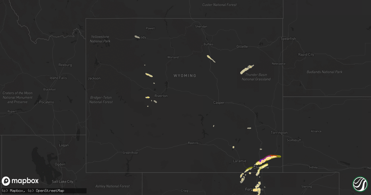
Hail Map in Wyoming on June 24, 2014
Get this storm
June 24 map
$229
one time, instant access
Download today. No call, no setup
Keep the $229
Bought the map and want the full workflow? Apply the entire $229 to a subscription within 7 days. None of it is wasted.
Every map, not just this one
This buys you this map. Subscription and you get every map we run, in the markets you choose from a few cities to whole states to nationwide. Plus real-time alerts the moment a storm fires.
Contact data
Name, contact info, occupancy, even credit band for addresses in the footprint. You go from where it hit to who to call.
Become the source they trust
Unlimited branding weather history reports on demand. You already have the documented answer ready for the property owner, and you are the one who showed up with it.
Property data and RoofTrace estimates
Pull up any address you have got, its value and the exact code rules for that jurisdiction, straight from One Click Code. Then RoofTrace estimates the squares, pitch, and roof value, priced the way you price.
Storm reports in Wyoming
Wyoming
| Date | Description |
|---|---|
| 06/24/20146:48 PM CDT | A local report indicates 1.00 inch wind near 14 W ALBIN |
| 06/24/20146:48 PM CDT | A local report indicates 1.00 inch wind near 9 W ALBIN |
| 06/24/20146:45 PM CDT | A local report indicates 1.00 inch wind near 16 W ALBIN |
| 06/24/20146:38 PM CDT | A local report indicates 1.75 inch wind near 14 W ALBIN |
| 06/24/20146:10 PM CDT | Actually measured 2.25 inches |
| 06/24/20145:53 PM CDT | A local report indicates 2.50 inch wind near 15 NE CHEYENNE |
| 06/24/20145:47 PM CDT | Quarter to ping pong size hail at mile marker 27 along us 85 |
| 06/24/20145:32 PM CDT | Significant damage to vehicles. Windshields broken and sunroof destroyed |
| 06/24/20145:31 PM CDT | Person in vehicle had cracked windshield from golfball size hail. Person located facing southbound on interstate 25 at mile marker 23. |
| 06/24/20145:30 PM CDT | A local report indicates 1.00 inch wind near 12 N CHEYENNE |
| 06/24/20145:23 PM CDT | Nickel to half dollar size hail. |
| 06/24/20145:10 PM CDT | A local report indicates 1.50 inch wind near 11 NW CHEYENNE |
| 06/24/20141:45 AM CDT | Quarter size hail on the north side of black thunder mine. |
| 06/24/20141:00 AM CDT | Average size 1 inch. Car dents and shredded leaves. |
| 06/23/201411:02 PM CDT | A local report indicates 1.00 inch wind near 5 NE CHEYENNE |
| 06/23/201410:56 PM CDT | A local report indicates 1.25 inch wind near 3 NE CHEYENNE |
| 06/23/201410:55 PM CDT | A local report indicates 1.50 inch wind near 3 NE CHEYENNE |
| 06/23/201410:54 PM CDT | A local report indicates 1.50 inch wind near 3 NE CHEYENNE |
| 06/23/201410:50 PM CDT | A local report indicates 1.50 inch wind near 3 NE CHEYENNE |
| 06/23/201410:49 PM CDT | A local report indicates 1.00 inch wind near 4 N CHEYENNE |
| 06/23/201410:48 PM CDT | Nickel to quarter size |
| 06/23/201410:35 PM CDT | Dime to quarter size hail on interstate 25 reported by truckers. |
| 06/23/20149:47 PM CDT | Quarter size hail along highway 287 just north of the colorado state line. |
| 06/23/20149:20 PM CDT | Hail is 2 inches deep on the road |
All States Impacted by Hail Map on June 24, 2014
Cities Impacted by Hail Map on June 24, 2014
- Winona, KS
- Timnath, CO
- Fort Collins, CO
- Cheyenne, WY
- Sublette, KS
- Garden City, KS
- Sharon, KS
- Amarillo, TX
- Ralston, OK
- Albin, WY
- Burns, WY
- Holly, CO
- Copeland, KS
- Monument, KS
- Tribune, KS
- Happy, TX
- Colorado Springs, CO
- Wallace, KS
- Ochelata, OK
- Ramona, OK
- Greensburg, KS
- Lamar, CO
- Granada, CO
- Hale Center, TX
- Plainview, TX
- Aurora, CO
- Watkins, CO
- Parker, CO
- Tulia, TX
- Dalhart, TX
- Haskell, TX
- Avoca, TX
- Stamford, TX
- Kismet, KS
- Satanta, KS
- Dozier, AL
- Hilbert, WI
- Offerle, KS
- Kress, TX
- Girard, TX
- Jayton, TX
- Spur, TX
- Walnut Springs, TX
- Meridian, TX
- Morgan, TX
- Liberal, KS
- Plains, KS
- Livermore, CO
- Limon, CO
- Medicine Lodge, KS
- Leoti, KS
- Troy, AL
- Scott City, KS
- Marienthal, KS
- Ingalls, KS
- Holcomb, KS
- Hillsdale, WY
- Marshall, OK
- Udall, KS
- Stratford, TX
- Arapaho, OK
- Santo, TX
- Yeso, NM
- Lancaster, TX
- Avondale, CO
- Cabot, PA
- Butler, PA
- Texline, TX
- Bentley, KS
- Valley Center, KS
- Sedgwick, KS
- Capitan, NM
- Haviland, KS
- Guymon, OK
- Goodwell, OK
- Carr, CO
- Floydada, TX
- Richmond, TX
- Crowell, TX
- Beeler, KS
- Dighton, KS
- Ness City, KS
- Jetmore, KS
- York, NE
- Waco, TX
- Woodson, TX
- Throckmorton, TX
- Rhome, TX
- Justin, TX
- Boyd, TX
- Haslet, TX
- Springtown, TX
- Azle, TX
- Newark, TX
- Kinsley, KS
- Stapleton, NE
- Tie Siding, WY
- Sharon Springs, KS
- Denver, CO
- Pavillion, WY
- Lockney, TX
- Wallace, NE
- Elsie, NE
- Healy, KS
- Spearville, KS
- Byers, CO
- Deer Trail, CO
- Kentwood, LA
- Colby, KS
- Weatherford, TX
- Idalou, TX
- Aspermont, TX
- Old Glory, TX
- Mooreland, OK
- Goree, TX
- Seymour, TX
- Pawhuska, OK
- Paxton, NE
- Alexandria, SD
- Bladen, NE
- Barnsdall, OK
- Cody, WY
- Brewton, AL
- Quitaque, TX
- Kinder, LA
- Turon, KS
- Matador, TX
- Flomot, TX
- Wildorado, TX
- Dimmitt, TX
- Nazareth, TX
- Graham, TX
- Turkey, TX
- Poolville, TX
- Elbert, CO
- Ben Wheeler, TX
- Fulton, SD
- Novelty, OH
- Chesterland, OH
- Gillette, WY
- Wellington, CO
- Nunn, CO
- Paducah, TX
- Fort Worth, TX
- Granite Canon, WY
- Lumberton, MS
- Calhan, CO
- Peyton, CO
- Gruver, TX
- Texhoma, OK
- Waldron, KS
- Amorita, OK
- Dexter, KS
- Cambridge, KS
- Grinnell, KS
- Dickens, TX
- Mitchell, SD
- Crosbyton, TX
- Syracuse, KS
- Atlanta, KS
- Mutual, OK
- Edson, KS
- De Berry, TX
- Bartlesville, OK
- Lakin, KS
- Pierceville, KS
- Deerfield, KS
- Ulysses, KS
- Colwich, KS
- Santa Rosa, NM
- Vaughn, NM
- Sedan, NM
- Goodland, KS
- Wichita, KS
- Red Feather Lakes, CO
- Bellvue, CO
- Oconto, NE
- Ramah, CO
- Simla, CO
- Corona, NM
- Bunkie, LA
- Rochester, TX
- St John, KS
- Isabel, KS
- Nashville, KS
- Daytona Beach, FL
- Ashland, KS
- Rule, TX
- Ogallala, NE
- Buffalo, WY
- Kaycee, WY
- Minneola, KS
- Petersburg, TX
- Quinter, KS
- Gove, KS
- Albany, TX
- Graford, TX
- Freer, TX
- Mulvane, KS
- Attica, KS
- Sawyer, KS
- Pratt, KS
- Concordia, KS
- Lipan, TX
- Derby, KS
- Comstock, TX
- Moody, TX
- McGregor, TX
- Lander, WY
- Macksville, KS
- Byers, KS
- Commerce City, CO
- Collyer, KS
- Utica, KS
- Agate, CO
- Windsor, CO
- Englewood, KS
- Hereford, TX
- Canyon, TX
- Benedict, NE
- Hordville, NE
- Hampton, NE
- Bradshaw, NE
- Polk, NE
- Canton, KS
- Trent, TX
- Merkel, TX
- Bosler, WY
- Macon, GA
- Evergreen, LA
- Florala, AL
- Lewis, KS
- Fort Lupton, CO
- Oakley, KS
- Mims, FL
- Osteen, FL
- Stephenville, TX
- Custer City, OK
- Stafford, KS
- Callaway, NE
- Broken Bow, NE
- Ozona, TX
- Shoshoni, WY
- Newcastle, TX
- Roy, NM
- Greensburg, LA
- Letcher, SD
- Douglas, OK
- Huntsville, TX
- Trinity, TX
- Lampasas, TX
- Johnstown, CO
- Fort Washakie, WY
- Picayune, MS
- Crawford, TX
- Platteville, CO
- Longmont, CO
- Strawn, TX
- Breckenridge, TX
- Talala, OK
- Stinnett, TX
- Morse, TX
- Sunray, TX
- Peck, KS
- Belle Plaine, KS
- Wellington, KS
- Riverton, WY
- New London, WI
- Woodland Park, CO
- Divide, CO
- Picacho, NM
- Perrin, TX
- Fargo, OK
- Maxwell, NM
- Wiggins, MS
- Littleton, CO
- New Smyrna Beach, FL
- Poplarville, MS
- Kaufman, TX
- Palo Pinto, TX
- Justice, IL
- Summit Argo, IL
- La Grange, IL
- Eaton, CO
- Fe Warren Afb, WY
- Uniontown, AL
- Berthoud, CO
- Loving, TX
- Beasley, TX
- East Bernard, TX
- Cleveland, TX
- Fowler, KS
- Chagrin Falls, OH
- Cleveland, OH
- Beachwood, OH
- Gates Mills, OH
- Arapahoe, NE
- Buford, WY
- Stockdale, TX
- Arlington, TX
- Dallas, TX
- New Brockton, AL
- Jack, AL
- Hutchins, TX
- Oakhurst, TX
- Pointblank, TX
- Hanston, KS
- Brundidge, AL
- Hanna, WY
- Shellman, GA
- Chatom, AL
- Saint Landry, LA
- Severance, CO
- Milliken, CO
- Milton, KS
- Lincoln, NM
- Hugoton, KS
- Ochopee, FL
- Shiocton, WI
- Clayton, NM
- Bear Creek, WI
- Elba, AL
- Westchester, IL
- Burbank, IL
- Chicago Ridge, IL
- Hinsdale, IL
- Brookfield, IL
- Western Springs, IL
- La Grange Park, IL
- Oak Lawn, IL
- Bridgeview, IL
- Hickory Hills, IL
- Dryden, TX
- Petrolia, PA
- Hydro, OK
- Haysville, KS
- Chicora, PA
- East Butler, PA
- Boise City, OK
- Lettsworth, LA
- Simmesport, LA
- Olney, TX
- Kopperl, TX
- Andalusia, AL
- Desoto, TX
- Red Oak, TX
- Bennett, CO
- Levant, KS
- Laredo, TX
- House, NM
- Artesian, SD
- Silverton, TX
- Ennis, TX
- New Orleans, LA
- Cornell, WI
- Pueblo, CO
- Ralls, TX
- Lueders, TX
- Lehigh, KS
- Liberty, MS
- Osyka, MS
- Magnolia, MS
- Pawnee, OK
- Jeffrey City, WY
- Clearwater, KS
- Kingman, KS
- Murdock, KS
- Folsom, NM
- Jermyn, TX
- Willis, TX
- Fort Davis, TX
- Las Vegas, NM
- Thermopolis, WY
- San Augustine, TX
- Valdosta, GA
- Cedar Vale, KS
- Burrton, KS
- Sedan, KS
- Pierce, CO
- Ault, CO
- Greeley, CO
- Buffalo, OK
- Lafayette, LA
- Breaux Bridge, LA
- Plaucheville, LA
- Bluff Dale, TX
- Dawson, TX
- Naval Air Station Jrb, TX
- Aledo, TX
- Logansport, LA
- Highlands, TX
- Scurry, TX
- Newton, TX
- Meriden, WY
- Merna, NE
- Weatherford, OK
- Wheatland, WY
- Wisdom, MT
- Hooker, OK
- Enterprise, AL
- Oswego, NY
- Sterling, NY
- Hannibal, NY
- Cottonport, LA


