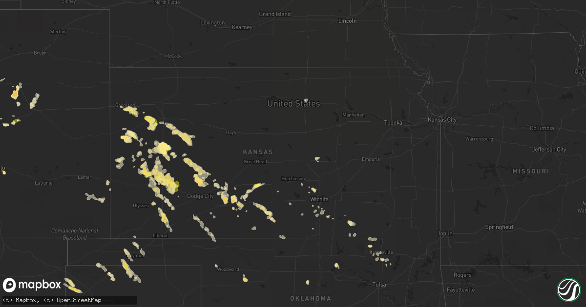
Hail Map in Kansas on June 24, 2014
Get this storm
June 24 map
$229
one time, instant access
Download today. No call, no setup
Keep the $229
Bought the map and want the full workflow? Apply the entire $229 to a subscription within 7 days. None of it is wasted.
Every map, not just this one
This buys you this map. Subscription and you get every map we run, in the markets you choose from a few cities to whole states to nationwide. Plus real-time alerts the moment a storm fires.
Contact data
Name, contact info, occupancy, even credit band for addresses in the footprint. You go from where it hit to who to call.
Become the source they trust
Unlimited branding weather history reports on demand. You already have the documented answer ready for the property owner, and you are the one who showed up with it.
Property data and RoofTrace estimates
Pull up any address you have got, its value and the exact code rules for that jurisdiction, straight from One Click Code. Then RoofTrace estimates the squares, pitch, and roof value, priced the way you price.
Storm reports in Kansas
Kansas
| Date | Description |
|---|---|
| 06/24/20146:00 PM CDT | A local report indicates 60 MPH wind near UDALL |
| 06/24/20146:00 PM CDT | Nickel to quarter size hail |
| 06/24/20145:00 PM CDT | A local report indicates 1.75 inch wind near 2 NW GREENSBURG |
| 06/24/20144:40 PM CDT | A local report indicates 85 MPH wind near 5 E GARDEN CITY |
| 06/24/20144:30 PM CDT | Consierable damage to a farmstead. A 2x4 was diven through a pickup windshield. A morton building was destroyed. A steel ladder was twisted around a grain bin. Another |
| 06/24/20144:22 PM CDT | A local report indicates 1.00 inch wind near 3 NNW PIERCEVILLE |
| 06/24/20144:16 PM CDT | A local report indicates 68 MPH wind near 5 E GARDEN CITY |
| 06/24/20144:10 PM CDT | A local report indicates 1.00 inch wind near 8 ESE WINDTHORST |
| 06/24/20144:10 PM CDT | A local report indicates 1.00 inch wind near 7 ENE GARDEN CITY |
| 06/24/20144:09 PM CDT | An industrial building was unroofed... A power pole was downed and trees were downed. |
| 06/24/20143:45 PM CDT | A local report indicates 1.00 inch wind near 11 N DEERFIELD |
| 06/24/20143:42 PM CDT | A local report indicates 65 MPH wind near HOLCOMB |
| 06/24/20143:25 PM CDT | A local report indicates 1.00 inch wind near 17 NNW DEERFIELD |
| 06/24/20143:05 PM CDT | A local report indicates 1.00 inch wind near 13 WSW FRIEND |
| 06/24/20143:05 PM CDT | A local report indicates 1.00 inch wind near 3 S ST. JOHN |
| 06/24/20142:55 PM CDT | The report was marble to golf ball size with 30 to 40 mph winds. |
| 06/24/20142:25 PM CDT | Nickel to quarter size hail. |
| 06/24/20141:52 PM CDT | Nickel to quarter sized hail was nearly covering the ground. |
| 06/24/20141:25 PM CDT | Nickel to quarter size hail. |
All States Impacted by Hail Map on June 24, 2014
Cities Impacted by Hail Map on June 24, 2014
- Winona, KS
- Timnath, CO
- Fort Collins, CO
- Cheyenne, WY
- Sublette, KS
- Garden City, KS
- Sharon, KS
- Amarillo, TX
- Ralston, OK
- Albin, WY
- Burns, WY
- Holly, CO
- Copeland, KS
- Monument, KS
- Tribune, KS
- Happy, TX
- Colorado Springs, CO
- Wallace, KS
- Ochelata, OK
- Ramona, OK
- Greensburg, KS
- Lamar, CO
- Granada, CO
- Hale Center, TX
- Plainview, TX
- Aurora, CO
- Watkins, CO
- Parker, CO
- Tulia, TX
- Dalhart, TX
- Haskell, TX
- Avoca, TX
- Stamford, TX
- Kismet, KS
- Satanta, KS
- Dozier, AL
- Hilbert, WI
- Offerle, KS
- Kress, TX
- Girard, TX
- Jayton, TX
- Spur, TX
- Walnut Springs, TX
- Meridian, TX
- Morgan, TX
- Liberal, KS
- Plains, KS
- Livermore, CO
- Limon, CO
- Medicine Lodge, KS
- Leoti, KS
- Troy, AL
- Scott City, KS
- Marienthal, KS
- Ingalls, KS
- Holcomb, KS
- Hillsdale, WY
- Marshall, OK
- Udall, KS
- Stratford, TX
- Arapaho, OK
- Santo, TX
- Yeso, NM
- Lancaster, TX
- Avondale, CO
- Cabot, PA
- Butler, PA
- Texline, TX
- Bentley, KS
- Valley Center, KS
- Sedgwick, KS
- Capitan, NM
- Haviland, KS
- Guymon, OK
- Goodwell, OK
- Carr, CO
- Floydada, TX
- Richmond, TX
- Crowell, TX
- Beeler, KS
- Dighton, KS
- Ness City, KS
- Jetmore, KS
- York, NE
- Waco, TX
- Woodson, TX
- Throckmorton, TX
- Rhome, TX
- Justin, TX
- Boyd, TX
- Haslet, TX
- Springtown, TX
- Azle, TX
- Newark, TX
- Kinsley, KS
- Stapleton, NE
- Tie Siding, WY
- Sharon Springs, KS
- Denver, CO
- Pavillion, WY
- Lockney, TX
- Wallace, NE
- Elsie, NE
- Healy, KS
- Spearville, KS
- Byers, CO
- Deer Trail, CO
- Kentwood, LA
- Colby, KS
- Weatherford, TX
- Idalou, TX
- Aspermont, TX
- Old Glory, TX
- Mooreland, OK
- Goree, TX
- Seymour, TX
- Pawhuska, OK
- Paxton, NE
- Alexandria, SD
- Bladen, NE
- Barnsdall, OK
- Cody, WY
- Brewton, AL
- Quitaque, TX
- Kinder, LA
- Turon, KS
- Matador, TX
- Flomot, TX
- Wildorado, TX
- Dimmitt, TX
- Nazareth, TX
- Graham, TX
- Turkey, TX
- Poolville, TX
- Elbert, CO
- Ben Wheeler, TX
- Fulton, SD
- Novelty, OH
- Chesterland, OH
- Gillette, WY
- Wellington, CO
- Nunn, CO
- Paducah, TX
- Fort Worth, TX
- Granite Canon, WY
- Lumberton, MS
- Calhan, CO
- Peyton, CO
- Gruver, TX
- Texhoma, OK
- Waldron, KS
- Amorita, OK
- Dexter, KS
- Cambridge, KS
- Grinnell, KS
- Dickens, TX
- Mitchell, SD
- Crosbyton, TX
- Syracuse, KS
- Atlanta, KS
- Mutual, OK
- Edson, KS
- De Berry, TX
- Bartlesville, OK
- Lakin, KS
- Pierceville, KS
- Deerfield, KS
- Ulysses, KS
- Colwich, KS
- Santa Rosa, NM
- Vaughn, NM
- Sedan, NM
- Goodland, KS
- Wichita, KS
- Red Feather Lakes, CO
- Bellvue, CO
- Oconto, NE
- Ramah, CO
- Simla, CO
- Corona, NM
- Bunkie, LA
- Rochester, TX
- St John, KS
- Isabel, KS
- Nashville, KS
- Daytona Beach, FL
- Ashland, KS
- Rule, TX
- Ogallala, NE
- Buffalo, WY
- Kaycee, WY
- Minneola, KS
- Petersburg, TX
- Quinter, KS
- Gove, KS
- Albany, TX
- Graford, TX
- Freer, TX
- Mulvane, KS
- Attica, KS
- Sawyer, KS
- Pratt, KS
- Concordia, KS
- Lipan, TX
- Derby, KS
- Comstock, TX
- Moody, TX
- McGregor, TX
- Lander, WY
- Macksville, KS
- Byers, KS
- Commerce City, CO
- Collyer, KS
- Utica, KS
- Agate, CO
- Windsor, CO
- Englewood, KS
- Hereford, TX
- Canyon, TX
- Benedict, NE
- Hordville, NE
- Hampton, NE
- Bradshaw, NE
- Polk, NE
- Canton, KS
- Trent, TX
- Merkel, TX
- Bosler, WY
- Macon, GA
- Evergreen, LA
- Florala, AL
- Lewis, KS
- Fort Lupton, CO
- Oakley, KS
- Mims, FL
- Osteen, FL
- Stephenville, TX
- Custer City, OK
- Stafford, KS
- Callaway, NE
- Broken Bow, NE
- Ozona, TX
- Shoshoni, WY
- Newcastle, TX
- Roy, NM
- Greensburg, LA
- Letcher, SD
- Douglas, OK
- Huntsville, TX
- Trinity, TX
- Lampasas, TX
- Johnstown, CO
- Fort Washakie, WY
- Picayune, MS
- Crawford, TX
- Platteville, CO
- Longmont, CO
- Strawn, TX
- Breckenridge, TX
- Talala, OK
- Stinnett, TX
- Morse, TX
- Sunray, TX
- Peck, KS
- Belle Plaine, KS
- Wellington, KS
- Riverton, WY
- New London, WI
- Woodland Park, CO
- Divide, CO
- Picacho, NM
- Perrin, TX
- Fargo, OK
- Maxwell, NM
- Wiggins, MS
- Littleton, CO
- New Smyrna Beach, FL
- Poplarville, MS
- Kaufman, TX
- Palo Pinto, TX
- Justice, IL
- Summit Argo, IL
- La Grange, IL
- Eaton, CO
- Fe Warren Afb, WY
- Uniontown, AL
- Berthoud, CO
- Loving, TX
- Beasley, TX
- East Bernard, TX
- Cleveland, TX
- Fowler, KS
- Chagrin Falls, OH
- Cleveland, OH
- Beachwood, OH
- Gates Mills, OH
- Arapahoe, NE
- Buford, WY
- Stockdale, TX
- Arlington, TX
- Dallas, TX
- New Brockton, AL
- Jack, AL
- Hutchins, TX
- Oakhurst, TX
- Pointblank, TX
- Hanston, KS
- Brundidge, AL
- Hanna, WY
- Shellman, GA
- Chatom, AL
- Saint Landry, LA
- Severance, CO
- Milliken, CO
- Milton, KS
- Lincoln, NM
- Hugoton, KS
- Ochopee, FL
- Shiocton, WI
- Clayton, NM
- Bear Creek, WI
- Elba, AL
- Westchester, IL
- Burbank, IL
- Chicago Ridge, IL
- Hinsdale, IL
- Brookfield, IL
- Western Springs, IL
- La Grange Park, IL
- Oak Lawn, IL
- Bridgeview, IL
- Hickory Hills, IL
- Dryden, TX
- Petrolia, PA
- Hydro, OK
- Haysville, KS
- Chicora, PA
- East Butler, PA
- Boise City, OK
- Lettsworth, LA
- Simmesport, LA
- Olney, TX
- Kopperl, TX
- Andalusia, AL
- Desoto, TX
- Red Oak, TX
- Bennett, CO
- Levant, KS
- Laredo, TX
- House, NM
- Artesian, SD
- Silverton, TX
- Ennis, TX
- New Orleans, LA
- Cornell, WI
- Pueblo, CO
- Ralls, TX
- Lueders, TX
- Lehigh, KS
- Liberty, MS
- Osyka, MS
- Magnolia, MS
- Pawnee, OK
- Jeffrey City, WY
- Clearwater, KS
- Kingman, KS
- Murdock, KS
- Folsom, NM
- Jermyn, TX
- Willis, TX
- Fort Davis, TX
- Las Vegas, NM
- Thermopolis, WY
- San Augustine, TX
- Valdosta, GA
- Cedar Vale, KS
- Burrton, KS
- Sedan, KS
- Pierce, CO
- Ault, CO
- Greeley, CO
- Buffalo, OK
- Lafayette, LA
- Breaux Bridge, LA
- Plaucheville, LA
- Bluff Dale, TX
- Dawson, TX
- Naval Air Station Jrb, TX
- Aledo, TX
- Logansport, LA
- Highlands, TX
- Scurry, TX
- Newton, TX
- Meriden, WY
- Merna, NE
- Weatherford, OK
- Wheatland, WY
- Wisdom, MT
- Hooker, OK
- Enterprise, AL
- Oswego, NY
- Sterling, NY
- Hannibal, NY
- Cottonport, LA


