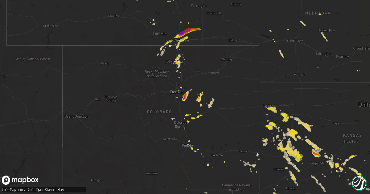
Hail Map on June 24, 2014
Get this storm
June 24 map
$229
one time, instant access
Download today. No call, no setup
Keep the $229
Bought the map and want the full workflow? Apply the entire $229 to a subscription within 7 days. None of it is wasted.
Every map, not just this one
This buys you this map. Subscription and you get every map we run, in the markets you choose from a few cities to whole states to nationwide. Plus real-time alerts the moment a storm fires.
Contact data
Name, contact info, occupancy, even credit band for addresses in the footprint. You go from where it hit to who to call.
Become the source they trust
Unlimited branding weather history reports on demand. You already have the documented answer ready for the property owner, and you are the one who showed up with it.
Property data and RoofTrace estimates
Pull up any address you have got, its value and the exact code rules for that jurisdiction, straight from One Click Code. Then RoofTrace estimates the squares, pitch, and roof value, priced the way you price.
States Impacted by Hail Map on June 24, 2014
Storm reports
Kansas
| Date | Description |
|---|---|
| 06/24/20146:00 PM CDT | A local report indicates 60 MPH wind near UDALL |
| 06/24/20146:00 PM CDT | Nickel to quarter size hail |
| 06/24/20145:00 PM CDT | A local report indicates 1.75 inch wind near 2 NW GREENSBURG |
| 06/24/20144:40 PM CDT | A local report indicates 85 MPH wind near 5 E GARDEN CITY |
| 06/24/20144:30 PM CDT | Consierable damage to a farmstead. A 2x4 was diven through a pickup windshield. A morton building was destroyed. A steel ladder was twisted around a grain bin. Another |
| 06/24/20144:22 PM CDT | A local report indicates 1.00 inch wind near 3 NNW PIERCEVILLE |
| 06/24/20144:16 PM CDT | A local report indicates 68 MPH wind near 5 E GARDEN CITY |
| 06/24/20144:10 PM CDT | A local report indicates 1.00 inch wind near 7 ENE GARDEN CITY |
| 06/24/20144:10 PM CDT | A local report indicates 1.00 inch wind near 8 ESE WINDTHORST |
| 06/24/20144:09 PM CDT | An industrial building was unroofed... A power pole was downed and trees were downed. |
| 06/24/20143:45 PM CDT | A local report indicates 1.00 inch wind near 11 N DEERFIELD |
| 06/24/20143:42 PM CDT | A local report indicates 65 MPH wind near HOLCOMB |
| 06/24/20143:25 PM CDT | A local report indicates 1.00 inch wind near 17 NNW DEERFIELD |
| 06/24/20143:05 PM CDT | A local report indicates 1.00 inch wind near 13 WSW FRIEND |
| 06/24/20143:05 PM CDT | A local report indicates 1.00 inch wind near 3 S ST. JOHN |
| 06/24/20142:55 PM CDT | The report was marble to golf ball size with 30 to 40 mph winds. |
| 06/24/20142:25 PM CDT | Nickel to quarter size hail. |
| 06/24/20141:52 PM CDT | Nickel to quarter sized hail was nearly covering the ground. |
| 06/24/20141:25 PM CDT | Nickel to quarter size hail. |
Wisconsin
| Date | Description |
|---|---|
| 06/24/20142:00 PM CDT | Tree branches 8in diameter broken off and several 10in diameter trees pushed over. A catamaran sail boat stored on shore was overturned. |
| 06/24/20141:53 PM CDT | A local report indicates 1.00 inch wind near 1 SE WEBSTER |
Florida
| Date | Description |
|---|---|
| 06/24/20143:11 PM CDT | Daytona beach international airport measured a wind gust to 57 kt/66 mph from 360 degrees. |
Ohio
| Date | Description |
|---|---|
| 06/24/20146:57 PM CDT | Multiple reports of trees and lines across roadways |
| 06/24/20146:48 PM CDT | Trees down on metz road |
| 06/24/20146:34 PM CDT | Trees down |
| 06/24/20146:30 PM CDT | Trees down on georgetown road |
| 06/24/20146:30 PM CDT | Trees down |
| 06/24/20146:03 PM CDT | Several trees downed on kennard kingscreek road. |
| 06/24/20145:45 PM CDT | Trees down blocking river road |
| 06/24/20144:10 PM CDT | Several trees down. |
| 06/24/20143:57 PM CDT | 1 tree down and power line down on front street. |
| 06/23/20147:14 PM CDT | Trees down along route 7 |
Colorado
| Date | Description |
|---|---|
| 06/24/20146:37 PM CDT | A local report indicates 1.00 inch wind near 6 NW PEYTON |
| 06/24/20144:54 PM CDT | A local report indicates 66 MPH wind near 11 S HOLLY |
| 06/24/20144:22 PM CDT | 0.32 inches of rain. |
| 06/24/20143:44 PM CDT | A local report indicates 1.00 inch wind near 2 NE FALCON |
| 06/24/20143:40 PM CDT | A local report indicates 1.00 inch wind near 2 E FALCON |
| 06/24/20143:39 PM CDT | A local report indicates 1.50 inch wind near 2 NNE FALCON |
| 06/24/201412:20 AM CDT | A local report indicates 1.25 inch wind near 4 SE FORT COLLINS |
| 06/24/201412:17 AM CDT | A local report indicates 2.00 inch wind near 4 S FORT COLLINS |
| 06/24/201412:05 AM CDT | A local report indicates 1.50 inch wind near 3 W FORT COLLINS |
| 06/24/201412:05 AM CDT | A local report indicates 1.25 inch wind near 2 SW FORT COLLINS |
| 06/24/201412:03 AM CDT | A local report indicates 1.00 inch wind near 2 SSW FORT COLLINS |
| 06/24/201412:01 AM CDT | A local report indicates 2.00 inch wind near 3 S FORT COLLINS |
| 06/24/201412:00 AM CDT | Windows damaged on the northside of a hotel at the intersection of harmony and timberline. Automobiles had broken windshields and dents. |
| 06/23/201411:59 PM CDT | A local report indicates 2.00 inch wind near 1 S FORT COLLINS |
| 06/23/201411:56 PM CDT | A local report indicates 1.25 inch wind near 2 WSW FORT COLLINS |
| 06/23/201411:54 PM CDT | A local report indicates 1.25 inch wind near 2 SE FORT COLLINS |
| 06/23/201411:50 PM CDT | A local report indicates 1.00 inch wind near 4 SE FORT COLLINS |
| 06/23/201411:50 PM CDT | Hail accumulation of 8 inches around corners of house. Skylight broken. |
| 06/23/201411:50 PM CDT | A local report indicates 1.00 inch wind near 1 ENE FORT COLLINS |
| 06/23/201411:45 PM CDT | Flowers and vegetable demolished... Window well covers broken... Lawn ornaments broken... Down spouts on ground and broken. Ground was totally covered with hail. |
| 06/23/201411:45 PM CDT | A local report indicates 1.00 inch wind near 1 SSW FORT COLLINS |
| 06/23/201411:45 PM CDT | A local report indicates 1.25 inch wind near 3 SW FORT COLLINS |
| 06/23/201411:40 PM CDT | Cars dented... Damaged shingles and shredded leaves. |
| 06/23/201411:30 PM CDT | A local report indicates 1.50 inch wind near 2 S FORT COLLINS |
| 06/23/201411:15 PM CDT | Car dents |
| 06/23/201410:50 PM CDT | A local report indicates 1.25 inch wind near 4 E FORT COLLINS |
| 06/23/201410:30 PM CDT | Lasted 15 minutes with minor leaf damage |
| 06/23/20149:38 PM CDT | A local report indicates 1.25 inch wind near 8 SSE BLENDE |
| 06/23/20149:38 PM CDT | A local report indicates 1.25 inch wind near 5 SSE BLENDE |
| 06/23/20149:32 PM CDT | A local report indicates 2.00 inch wind near 8 SE AURORA |
| 06/23/20149:28 PM CDT | A local report indicates 1.75 inch wind near 9 ESE AURORA |
| 06/23/20149:20 PM CDT | A local report indicates 1.75 inch wind near 8 SSE BYERS |
| 06/23/20149:17 PM CDT | A local report indicates 2.00 inch wind near 7 SE AURORA |
| 06/23/20149:08 PM CDT | A local report indicates 1.25 inch wind near 4 WSW ARAPAHOE PARK |
| 06/23/20149:05 PM CDT | A local report indicates 1.00 inch wind near 5 NNE PARKER |
| 06/23/20149:03 PM CDT | A local report indicates 2.00 inch wind near 4 NE PARKER |
| 06/23/20148:55 PM CDT | A local report indicates 1.00 inch wind near 5 NE DENVER |
| 06/23/20148:46 PM CDT | A local report indicates 1.50 inch wind near 2 NNE PARKER |
| 06/23/20148:45 PM CDT | A local report indicates 1.00 inch wind near 1 E PARKER |
| 06/23/20148:45 PM CDT | 1.40 inches of rain |
| 06/23/20148:44 PM CDT | A local report indicates 1.00 inch wind near PARKER |
Mississippi
| Date | Description |
|---|---|
| 06/24/20146:30 PM CDT | Two trees were blown down across hwy 49 |
| 06/24/20146:00 PM CDT | Several trees down near lumberton...reported by lamar so |
Louisiana
| Date | Description |
|---|---|
| 06/24/20144:12 PM CDT | *** 2 inj *** trees down on homes. Powerlines downed in kentwood. Two children transported to hospital with unknown injuries. |
| 06/24/20142:53 PM CDT | Tree fell on a house and a rood was blown off a mobile home in innis. |
| 06/24/20141:50 PM CDT | Trees reported down on highway 977 in valverda. |
| 06/24/201411:44 AM CDT | Power lines and trees down reported by em. |
Indiana
| Date | Description |
|---|---|
| 06/24/20144:00 PM CDT | Limbs down on power lines. One tree down north of indiana avenue. Time estimated. |
| 06/24/20141:37 PM CDT | Camper tossed onto roof of home destroying the camper and approximately half of the roof facing the street. Tornado damage rating ef-1 with estimated winds of 100 mph. |
| 06/24/20141:32 PM CDT | Tornado on the ground with debris. At perry road and us 40 just east of plainfield. |
| 06/24/20141:31 PM CDT | Camper apparently was tossed onto roof of home destroying the camper and approximately half of the roof facing the street. Tornado damage rating ef-1. Estimated time. |
| 06/24/20141:31 PM CDT | Tree limbs down all along bridgeport road. Time estimated. |
| 06/24/20141:31 PM CDT | Camper apparently was tossed onto roof of home destroying the camper and approximately half of the roof facing the street. Tornado damage rating ef-1. Estimated time. |
| 06/24/20141:31 PM CDT | 200 plus cars were damaged at auto auction at adesa at 2950 east main street |
| 06/24/20141:31 PM CDT | Utility poles were snapped or leaning. The snapped one was broken 3 to 4 feet above ground level. Trees were snapped or uprooted. Roofing damage. Lawn furniture was str |
Georgia
| Date | Description |
|---|---|
| 06/24/20146:57 PM CDT | Power line down at 200 block of west bolton street. |
| 06/24/20146:56 PM CDT | Tree down at the intersection of habersham street and maupas avenue. |
| 06/24/20146:56 PM CDT | Tree down at the intersection of west victory drive and martin luther king jr boulevard. |
| 06/24/20146:55 PM CDT | Trees down at the arbors off of benton boulevard. |
| 06/24/20146:52 PM CDT | Tree down at the intersection of reid street and rothwell street. |
| 06/24/20146:50 PM CDT | Spotter reported windows blown out of the back of a house off windsor on the marsh. |
| 06/24/20146:30 PM CDT | Warning point reported power lines down at the intersection of belle island road and kilkenny road. |
| 06/24/20146:15 PM CDT | Warning point reported 2 trees down on highway 99. One near carnigan and the other at milemarker 13. |
| 06/24/20146:10 PM CDT | Warning point reported tree down on belle hammock road. |
| 06/24/20145:45 PM CDT | Warning point reported tree down on highway 57. |
| 06/24/20145:25 PM CDT | A tree was blown down on beechwood drive. |
| 06/24/20145:18 PM CDT | Widespread trees and power lines were blown down across the nahunta area. |
| 06/24/20145:13 PM CDT | A tree was blown down in winokur. |
| 06/24/20145:10 PM CDT | Trees and power lines were blown down across hortense. |
| 06/24/20144:55 PM CDT | Widespread tree damage within blackshear. |
| 06/24/20144:35 PM CDT | Widespread extensive wind damage across northern ware county from manor to waycross. Trees down and power lines down. |
Texas
| Date | Description |
|---|---|
| 06/24/20145:45 PM CDT | Large tree down in pilot point |
| 06/24/20145:05 PM CDT | Light poles blown over at grocery store in trophy club |
| 06/24/20144:53 PM CDT | Estimated 60 mph winds in new fairview |
| 06/24/20144:40 PM CDT | Large tree blown down in fort worth at southwestern seminary |
| 06/24/20144:10 PM CDT | 4 trees down |
| 06/24/20144:07 PM CDT | Tyler pounds field airport |
| 06/24/20143:37 PM CDT | Kgky asos measured a 52 kt wind |
| 06/24/20142:10 PM CDT | A local report indicates 62 MPH wind near 3 NW SEYMOUR |
| 06/24/20148:15 AM CDT | A local report indicates 1.00 inch wind near 14 E HEREFORD |
| 06/24/20147:55 AM CDT | A local report indicates 66 MPH wind near 5 ENE HEREFORD |
| 06/24/20147:35 AM CDT | A local report indicates 59 MPH wind near 5 ENE HEREFORD |
| 06/24/20147:02 AM CDT | A local report indicates 1.00 inch wind near 2 N UMBARGER |
| 06/23/201410:03 PM CDT | A local report indicates 60 MPH wind near MORSE |
Nebraska
| Date | Description |
|---|---|
| 06/24/20146:15 PM CDT | Outbuilding and irrigation pivots overturned... 4 year old cottonwood tree bent over... Chimical tote blown over... Hail also reported. Time estimated by radar... Delayed rep |
| 06/23/20147:15 PM CDT | Outbuilding and irrigation pivots overturned... 4 year old cottonwood tree bent over... Chimical tote blown over... Hail also reported. Time estimated by radar... Delayed rep |
Wyoming
| Date | Description |
|---|---|
| 06/24/20146:48 PM CDT | A local report indicates 1.00 inch wind near 14 W ALBIN |
| 06/24/20146:48 PM CDT | A local report indicates 1.00 inch wind near 9 W ALBIN |
| 06/24/20146:45 PM CDT | A local report indicates 1.00 inch wind near 16 W ALBIN |
| 06/24/20146:38 PM CDT | A local report indicates 1.75 inch wind near 14 W ALBIN |
| 06/24/20146:10 PM CDT | Actually measured 2.25 inches |
| 06/24/20145:53 PM CDT | A local report indicates 2.50 inch wind near 15 NE CHEYENNE |
| 06/24/20145:47 PM CDT | Quarter to ping pong size hail at mile marker 27 along us 85 |
| 06/24/20145:32 PM CDT | Significant damage to vehicles. Windshields broken and sunroof destroyed |
| 06/24/20145:31 PM CDT | Person in vehicle had cracked windshield from golfball size hail. Person located facing southbound on interstate 25 at mile marker 23. |
| 06/24/20145:30 PM CDT | A local report indicates 1.00 inch wind near 12 N CHEYENNE |
| 06/24/20145:23 PM CDT | Nickel to half dollar size hail. |
| 06/24/20145:10 PM CDT | A local report indicates 1.50 inch wind near 11 NW CHEYENNE |
| 06/24/20141:45 AM CDT | Quarter size hail on the north side of black thunder mine. |
| 06/24/20141:00 AM CDT | Average size 1 inch. Car dents and shredded leaves. |
| 06/23/201411:02 PM CDT | A local report indicates 1.00 inch wind near 5 NE CHEYENNE |
| 06/23/201410:56 PM CDT | A local report indicates 1.25 inch wind near 3 NE CHEYENNE |
| 06/23/201410:55 PM CDT | A local report indicates 1.50 inch wind near 3 NE CHEYENNE |
| 06/23/201410:54 PM CDT | A local report indicates 1.50 inch wind near 3 NE CHEYENNE |
| 06/23/201410:50 PM CDT | A local report indicates 1.50 inch wind near 3 NE CHEYENNE |
| 06/23/201410:49 PM CDT | A local report indicates 1.00 inch wind near 4 N CHEYENNE |
| 06/23/201410:48 PM CDT | Nickel to quarter size |
| 06/23/201410:35 PM CDT | Dime to quarter size hail on interstate 25 reported by truckers. |
| 06/23/20149:47 PM CDT | Quarter size hail along highway 287 just north of the colorado state line. |
| 06/23/20149:20 PM CDT | Hail is 2 inches deep on the road |
Alabama
| Date | Description |
|---|---|
| 06/24/20143:45 PM CDT | Tree down on mincey bridge road |
| 06/24/20143:45 PM CDT | Tree down across county road 5 near county road 245. |
| 06/24/20143:02 PM CDT | A tree was knocked down at the intersection of friendship road and glendale road. Power was also reported out in the guntersville area. |
Oklahoma
| Date | Description |
|---|---|
| 06/23/20148:44 PM CDT | A local report indicates 60 MPH wind near 3 W TEXHOMA |
| 06/23/20148:00 PM CDT | A local report indicates 58 MPH wind near 2 SW GAGE |
Pennsylvania
| Date | Description |
|---|---|
| 06/24/20146:53 PM CDT | Several roads with trees and lines blocking them in madison township |
| 06/24/20146:53 PM CDT | Ten trees down on concord church road |
| 06/24/20146:15 PM CDT | Four trees down blocking spruce hollow rd |
| 06/24/20146:05 PM CDT | Trees down |
| 06/24/20146:05 PM CDT | Trees down. |
| 06/24/20146:05 PM CDT | Trees down. |
| 06/24/20145:58 PM CDT | Several trees down. Semi trailer blown over. |
| 06/24/20145:55 PM CDT | Numerous trees... Poles and wires down on state route 228 |
| 06/24/20145:40 PM CDT | Trees and power lines down in ambridge. |
| 06/24/20145:30 PM CDT | 1.0 mile width and 0.5 miles wide. At least 50 trees down in glenwillard and four homes damaged due to trees falling on them |
| 06/24/20145:15 PM CDT | Trees and wires down |
| 06/24/20143:22 PM CDT | Large oak tree on blue jay rd |
| 06/23/20147:05 PM CDT | Multiple roads with trees and lines blocking them in wayne township |
New York
| Date | Description |
|---|---|
| 06/24/20146:00 PM CDT | Tree and some wires down |
| 06/24/20145:57 PM CDT | Tree on wires |
| 06/24/20145:38 PM CDT | Trees down |
| 06/24/20145:24 PM CDT | Tree down across road |
| 06/24/20145:24 PM CDT | Tree partially blocking roadway |
| 06/24/20145:19 PM CDT | Trees down |
| 06/24/20145:08 PM CDT | Large tree on house |
| 06/24/20144:54 PM CDT | Tree down blocking roadway. |
| 06/24/20144:48 PM CDT | Trees down |
| 06/24/20144:46 PM CDT | Tree blocking roadway near corner of lake bluff rd and lummisville rd |
| 06/24/20144:46 PM CDT | Trees down |
| 06/24/20144:43 PM CDT | Trees and wires down on aikens road |
| 06/24/20144:20 PM CDT | *** 2 fatal *** tree and wires down on car on pre emption road. |
| 06/24/20144:18 PM CDT | Multiple reports of trees and wires down across the area |
| 06/23/20147:04 PM CDT | Tree and wires down on south elm street |
Cities Impacted by Hail Map on June 24, 2014
- Winona, KS
- Timnath, CO
- Fort Collins, CO
- Cheyenne, WY
- Sublette, KS
- Garden City, KS
- Sharon, KS
- Amarillo, TX
- Ralston, OK
- Albin, WY
- Burns, WY
- Holly, CO
- Copeland, KS
- Monument, KS
- Tribune, KS
- Happy, TX
- Colorado Springs, CO
- Wallace, KS
- Ochelata, OK
- Ramona, OK
- Greensburg, KS
- Lamar, CO
- Granada, CO
- Hale Center, TX
- Plainview, TX
- Aurora, CO
- Watkins, CO
- Parker, CO
- Tulia, TX
- Dalhart, TX
- Haskell, TX
- Avoca, TX
- Stamford, TX
- Kismet, KS
- Satanta, KS
- Dozier, AL
- Hilbert, WI
- Offerle, KS
- Kress, TX
- Girard, TX
- Jayton, TX
- Spur, TX
- Walnut Springs, TX
- Meridian, TX
- Morgan, TX
- Liberal, KS
- Plains, KS
- Livermore, CO
- Limon, CO
- Medicine Lodge, KS
- Leoti, KS
- Troy, AL
- Scott City, KS
- Marienthal, KS
- Ingalls, KS
- Holcomb, KS
- Hillsdale, WY
- Marshall, OK
- Udall, KS
- Stratford, TX
- Arapaho, OK
- Santo, TX
- Yeso, NM
- Lancaster, TX
- Avondale, CO
- Cabot, PA
- Butler, PA
- Texline, TX
- Bentley, KS
- Valley Center, KS
- Sedgwick, KS
- Capitan, NM
- Haviland, KS
- Guymon, OK
- Goodwell, OK
- Carr, CO
- Floydada, TX
- Richmond, TX
- Crowell, TX
- Beeler, KS
- Dighton, KS
- Ness City, KS
- Jetmore, KS
- York, NE
- Waco, TX
- Woodson, TX
- Throckmorton, TX
- Rhome, TX
- Justin, TX
- Boyd, TX
- Haslet, TX
- Springtown, TX
- Azle, TX
- Newark, TX
- Kinsley, KS
- Stapleton, NE
- Tie Siding, WY
- Sharon Springs, KS
- Denver, CO
- Pavillion, WY
- Lockney, TX
- Wallace, NE
- Elsie, NE
- Healy, KS
- Spearville, KS
- Byers, CO
- Deer Trail, CO
- Kentwood, LA
- Colby, KS
- Weatherford, TX
- Idalou, TX
- Aspermont, TX
- Old Glory, TX
- Mooreland, OK
- Goree, TX
- Seymour, TX
- Pawhuska, OK
- Paxton, NE
- Alexandria, SD
- Bladen, NE
- Barnsdall, OK
- Cody, WY
- Brewton, AL
- Quitaque, TX
- Kinder, LA
- Turon, KS
- Matador, TX
- Flomot, TX
- Wildorado, TX
- Dimmitt, TX
- Nazareth, TX
- Graham, TX
- Turkey, TX
- Poolville, TX
- Elbert, CO
- Ben Wheeler, TX
- Fulton, SD
- Novelty, OH
- Chesterland, OH
- Gillette, WY
- Wellington, CO
- Nunn, CO
- Paducah, TX
- Fort Worth, TX
- Granite Canon, WY
- Lumberton, MS
- Calhan, CO
- Peyton, CO
- Gruver, TX
- Texhoma, OK
- Waldron, KS
- Amorita, OK
- Dexter, KS
- Cambridge, KS
- Grinnell, KS
- Dickens, TX
- Mitchell, SD
- Crosbyton, TX
- Syracuse, KS
- Atlanta, KS
- Mutual, OK
- Edson, KS
- De Berry, TX
- Bartlesville, OK
- Lakin, KS
- Pierceville, KS
- Deerfield, KS
- Ulysses, KS
- Colwich, KS
- Santa Rosa, NM
- Vaughn, NM
- Sedan, NM
- Goodland, KS
- Wichita, KS
- Red Feather Lakes, CO
- Bellvue, CO
- Oconto, NE
- Ramah, CO
- Simla, CO
- Corona, NM
- Bunkie, LA
- Rochester, TX
- St John, KS
- Isabel, KS
- Nashville, KS
- Daytona Beach, FL
- Ashland, KS
- Rule, TX
- Ogallala, NE
- Buffalo, WY
- Kaycee, WY
- Minneola, KS
- Petersburg, TX
- Quinter, KS
- Gove, KS
- Albany, TX
- Graford, TX
- Freer, TX
- Mulvane, KS
- Attica, KS
- Sawyer, KS
- Pratt, KS
- Concordia, KS
- Lipan, TX
- Derby, KS
- Comstock, TX
- Moody, TX
- McGregor, TX
- Lander, WY
- Macksville, KS
- Byers, KS
- Commerce City, CO
- Collyer, KS
- Utica, KS
- Agate, CO
- Windsor, CO
- Englewood, KS
- Hereford, TX
- Canyon, TX
- Benedict, NE
- Hordville, NE
- Hampton, NE
- Bradshaw, NE
- Polk, NE
- Canton, KS
- Trent, TX
- Merkel, TX
- Bosler, WY
- Macon, GA
- Evergreen, LA
- Florala, AL
- Lewis, KS
- Fort Lupton, CO
- Oakley, KS
- Mims, FL
- Osteen, FL
- Stephenville, TX
- Custer City, OK
- Stafford, KS
- Callaway, NE
- Broken Bow, NE
- Ozona, TX
- Shoshoni, WY
- Newcastle, TX
- Roy, NM
- Greensburg, LA
- Letcher, SD
- Douglas, OK
- Huntsville, TX
- Trinity, TX
- Lampasas, TX
- Johnstown, CO
- Fort Washakie, WY
- Picayune, MS
- Crawford, TX
- Platteville, CO
- Longmont, CO
- Strawn, TX
- Breckenridge, TX
- Talala, OK
- Stinnett, TX
- Morse, TX
- Sunray, TX
- Peck, KS
- Belle Plaine, KS
- Wellington, KS
- Riverton, WY
- New London, WI
- Woodland Park, CO
- Divide, CO
- Picacho, NM
- Perrin, TX
- Fargo, OK
- Maxwell, NM
- Wiggins, MS
- Littleton, CO
- New Smyrna Beach, FL
- Poplarville, MS
- Kaufman, TX
- Palo Pinto, TX
- Justice, IL
- Summit Argo, IL
- La Grange, IL
- Eaton, CO
- Fe Warren Afb, WY
- Uniontown, AL
- Berthoud, CO
- Loving, TX
- Beasley, TX
- East Bernard, TX
- Cleveland, TX
- Fowler, KS
- Chagrin Falls, OH
- Cleveland, OH
- Beachwood, OH
- Gates Mills, OH
- Arapahoe, NE
- Buford, WY
- Stockdale, TX
- Arlington, TX
- Dallas, TX
- New Brockton, AL
- Jack, AL
- Hutchins, TX
- Oakhurst, TX
- Pointblank, TX
- Hanston, KS
- Brundidge, AL
- Hanna, WY
- Shellman, GA
- Chatom, AL
- Saint Landry, LA
- Severance, CO
- Milliken, CO
- Milton, KS
- Lincoln, NM
- Hugoton, KS
- Ochopee, FL
- Shiocton, WI
- Clayton, NM
- Bear Creek, WI
- Elba, AL
- Westchester, IL
- Burbank, IL
- Chicago Ridge, IL
- Hinsdale, IL
- Brookfield, IL
- Western Springs, IL
- La Grange Park, IL
- Oak Lawn, IL
- Bridgeview, IL
- Hickory Hills, IL
- Dryden, TX
- Petrolia, PA
- Hydro, OK
- Haysville, KS
- Chicora, PA
- East Butler, PA
- Boise City, OK
- Lettsworth, LA
- Simmesport, LA
- Olney, TX
- Kopperl, TX
- Andalusia, AL
- Desoto, TX
- Red Oak, TX
- Bennett, CO
- Levant, KS
- Laredo, TX
- House, NM
- Artesian, SD
- Silverton, TX
- Ennis, TX
- New Orleans, LA
- Cornell, WI
- Pueblo, CO
- Ralls, TX
- Lueders, TX
- Lehigh, KS
- Liberty, MS
- Osyka, MS
- Magnolia, MS
- Pawnee, OK
- Jeffrey City, WY
- Clearwater, KS
- Kingman, KS
- Murdock, KS
- Folsom, NM
- Jermyn, TX
- Willis, TX
- Fort Davis, TX
- Las Vegas, NM
- Thermopolis, WY
- San Augustine, TX
- Valdosta, GA
- Cedar Vale, KS
- Burrton, KS
- Sedan, KS
- Pierce, CO
- Ault, CO
- Greeley, CO
- Buffalo, OK
- Lafayette, LA
- Breaux Bridge, LA
- Plaucheville, LA
- Bluff Dale, TX
- Dawson, TX
- Naval Air Station Jrb, TX
- Aledo, TX
- Logansport, LA
- Highlands, TX
- Scurry, TX
- Newton, TX
- Meriden, WY
- Merna, NE
- Weatherford, OK
- Wheatland, WY
- Wisdom, MT
- Hooker, OK
- Enterprise, AL
- Oswego, NY
- Sterling, NY
- Hannibal, NY
- Cottonport, LA