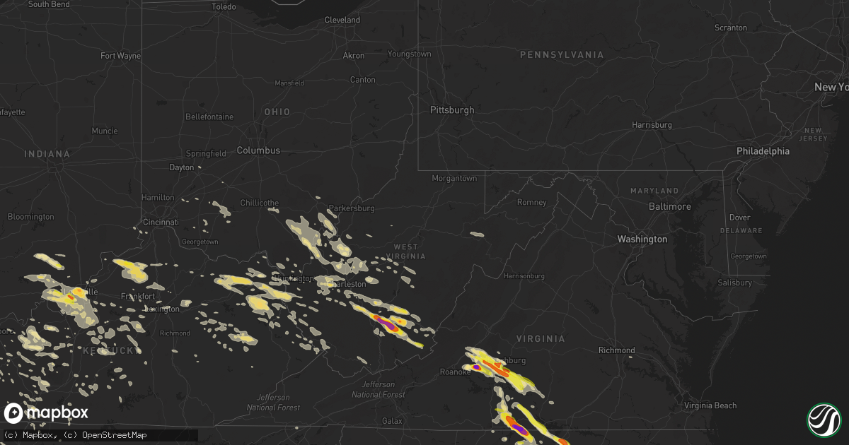
Hail Map in West Virginia on June 23, 2016
Get this storm
June 23 map
$229
one time, instant access
Download today. No call, no setup
Keep the $229
Bought the map and want the full workflow? Apply the entire $229 to a subscription within 7 days. None of it is wasted.
Every map, not just this one
This buys you this map. Subscription and you get every map we run, in the markets you choose from a few cities to whole states to nationwide. Plus real-time alerts the moment a storm fires.
Contact data
Name, contact info, occupancy, even credit band for addresses in the footprint. You go from where it hit to who to call.
Become the source they trust
Unlimited branding weather history reports on demand. You already have the documented answer ready for the property owner, and you are the one who showed up with it.
Property data and RoofTrace estimates
Pull up any address you have got, its value and the exact code rules for that jurisdiction, straight from One Click Code. Then RoofTrace estimates the squares, pitch, and roof value, priced the way you price.
Storm reports in West Virginia
West Virginia
| Date | Description |
|---|---|
| 06/23/20166:45 PM CDT | 911 reports of one tree down on falls mill road near bluefield west virginia. |
| 06/23/20166:45 PM CDT | Thunderstorm wind caused numerous trees to come down along route 102 within mercer county causing temporary closures on the wv side of the border. |
| 06/23/20166:15 PM CDT | Several trees reported down. Time estimated from radar. |
| 06/23/20165:55 PM CDT | Numerous reports of trees down throughout wyoming county...including route 54. |
| 06/23/20165:45 PM CDT | Trees down |
| 06/23/20165:35 PM CDT | Trees down in mcgraws. Time estimated from radar. |
| 06/23/20165:35 PM CDT | Some trees down... Road blocked. |
| 06/23/20165:25 PM CDT | Trees down along route 85. |
| 06/23/20165:10 PM CDT | Trees down around town. |
| 06/23/20165:08 PM CDT | Trees down... Roads blocked. |
| 06/23/20164:08 PM CDT | Trained spotter reports trees down on auto road near renick west virginia. |
| 06/23/20164:05 PM CDT | Trees down between dunlow and genoa along sr 152 |
| 06/23/20163:15 PM CDT | Public reports quarter size hail near union west virginia. |
| 06/23/20163:08 PM CDT | Numerous trees down. Time estimated from radar. |
| 06/23/20163:04 PM CDT | Tree down at spencer rd and elk river rd n |
| 06/23/20162:57 PM CDT | Four trees down in clendenin |
| 06/23/20162:53 PM CDT | Trees down in ceredo. |
| 06/23/20162:45 PM CDT | Tree down in home brew hollow |
| 06/23/20162:35 PM CDT | Several trees down. |
| 06/23/20162:15 PM CDT | A local report indicates 2.00 inch wind near 1 E MEADOW BRIDGE |
| 06/23/20162:15 PM CDT | A local report indicates 2.00 inch wind near 2 W MEADOW BRIDGE |
| 06/23/20161:58 PM CDT | A local report indicates 1.50 inch wind near OAK HILL |
| 06/23/20161:43 PM CDT | Large limbs down at residence on lick fork run. Time estimated from radar |
| 06/23/20167:42 AM CDT | Large apple tree snapped and fell on a fence...picture found on social media and time estimated by radar. |
| 06/23/20167:42 AM CDT | Trees down in pipestem area. Time radar estimated. |
| 06/23/20167:30 AM CDT | Trees down along elk knob rd in hinton. Time radar estimated. |
| 06/23/20167:30 AM CDT | One tree blown down by thunderstorm winds on route 12. |
| 06/23/20167:30 AM CDT | Trees down in the jumping branch area. Time radar estimated. |
| 06/23/20167:26 AM CDT | Couple of trees blown down on willow wood road. |
| 06/23/20167:25 AM CDT | Tree and wires down across east whidby road in shady spring |
| 06/23/20167:25 AM CDT | Tree down across coal city road...corrected for time to 825 am instead of 825 pm |
| 06/23/20167:24 AM CDT | Multiple trees down along rte 20 north of hinton. Time radar estimated. |
| 06/23/20167:20 AM CDT | One tree blown down by thunderstorm winds on route 20. |
| 06/23/20167:20 AM CDT | One tree blown down by thunderstorm winds. |
| 06/23/20167:15 AM CDT | Tree down across airport road in beaver |
| 06/23/20167:15 AM CDT | Tree across maxwell hill road in beckley |
| 06/23/20167:14 AM CDT | Trees and wires down and fell on two cars parked in a driveway. Damage picture found on social media and report estimated by radar. |
| 06/23/20167:05 AM CDT | Tree and wires down across peach tree road in naoma |
| 06/22/20167:25 PM CDT | Tree down across coal city road |
All States Impacted by Hail Map on June 23, 2016
Cities Impacted by Hail Map on June 23, 2016
- Java, VA
- Vernon Hill, VA
- Wellington, KS
- Newkirk, OK
- Ponca City, OK
- Wellston, OH
- Bidwell, OH
- Vinton, OH
- Apple Grove, WV
- Southside, WV
- Thurman, OH
- Gallipolis Ferry, WV
- Henderson, WV
- Jackson, OH
- Gallipolis, OH
- Snow Camp, NC
- Graham, NC
- Clarkson, KY
- Bedford, VA
- Thaxton, VA
- Moneta, VA
- Fort Morgan, CO
- Prairie City, SD
- Rustburg, VA
- Goode, VA
- Evington, VA
- Gladys, VA
- Lowry, VA
- Forest, VA
- Lynchburg, VA
- Buffalo, SD
- Reva, SD
- Kinsley, KS
- Garfield, KS
- Dix, NE
- Martha, KY
- Keaton, KY
- East Lynn, WV
- Wayne, WV
- Isonville, KY
- Olive Hill, KY
- Prichard, WV
- Denton, KY
- Wallingford, KY
- Louisa, KY
- Grayson, KY
- Webbville, KY
- Blaine, KY
- Hitchins, KY
- Flemingsburg, KY
- Sitka, KY
- Morehead, KY
- Flatgap, KY
- Catlettsburg, KY
- Genoa, WV
- Fort Gay, WV
- Emerson, KY
- Sandy Hook, KY
- Vanceburg, KY
- Stambaugh, KY
- Rush, KY
- Otis, CO
- Akron, CO
- Rock, KS
- Atlanta, KS
- Douglass, KS
- Pittsburg, KS
- Cherokee, KS
- Weir, KS
- Jetmore, KS
- Fountain Run, KY
- Liberty, NC
- Conway Springs, KS
- Lamar, MO
- Eskdale, WV
- Gallagher, WV
- Montgomery, WV
- Ford, KS
- Belle Plaine, KS
- Sandstone, WV
- Meadow Bridge, WV
- Meadow Creek, WV
- Danese, WV
- Shady Spring, WV
- Bowling Green, KY
- Smiths Grove, KY
- Burrton, KS
- Alderson, WV
- Sinks Grove, WV
- Union, WV
- Wolfcreek, WV
- Bridgeport, NE
- Knob Lick, KY
- Edmonton, KY
- Glasgow, KY
- Bardstown, KY
- Bloomfield, KY
- Ulysses, KY
- Bethpage, TN
- Portland, TN
- South Boston, VA
- Virgilina, VA
- Alton, VA
- Roxboro, NC
- Elizabeth, IN
- Wray, CO
- Elizabethtown, KY
- Longton, KS
- Elk City, KS
- Sedan, KS
- Lodgepole, SD
- Franklin, KY
- Barboursville, WV
- Spring Hope, NC
- Zebulon, NC
- Yates Center, KS
- Merino, CO
- Stoneham, CO
- Hurt, VA
- Gretna, VA
- Medford, OK
- Kenna, WV
- Given, WV
- Liberty, WV
- Victoria, VA
- Chase City, VA
- Bayard, NE
- Morrisville, NC
- Vancleve, KY
- Hazel Green, KY
- Mize, KY
- West Liberty, KY
- Rousseau, KY
- Salyersville, KY
- Cannel City, KY
- Royalton, KY
- Jackson, KY
- Campton, KY
- Pittsboro, NC
- Mullinville, KS
- Hepler, KS
- Uniontown, KS
- Mulberry, KS
- Arma, KS
- Girard, KS
- Arcadia, KS
- Bronaugh, MO
- Walnut, KS
- Fort Scott, KS
- Garland, KS
- Liberal, MO
- Farlington, KS
- Mindenmines, MO
- Radcliff, KY
- Gridley, KS
- Kanawha Falls, WV
- Victor, WV
- Gauley Bridge, WV
- Fayetteville, WV
- Ansted, WV
- Stanton, KY
- Hamlin, WV
- Griffithsville, WV
- Sumerco, WV
- Nitro, WV
- Poca, WV
- Sod, WV
- Winfield, WV
- Alum Creek, WV
- Charleston, WV
- Dunbar, WV
- Scott Depot, WV
- Hurricane, WV
- Saint Albans, WV
- Yawkey, WV
- Culloden, WV
- Milton, WV
- Tornado, WV
- South Charleston, WV
- Hillsboro, OH
- Lynchburg, OH
- Sardinia, OH
- Hutchinson, KS
- Harned, KY
- Sacramento, KY
- Madisonville, KY
- Hanson, KY
- Ash Grove, MO
- Springfield, MO
- Bois D Arc, MO
- Frankfort, KY
- Rockfield, KY
- Morgantown, KY
- Auburn, KY
- Russellville, KY
- Kimball, NE
- Tucumcari, NM
- Washington, NC
- Halifax, VA
- Scottsburg, VA
- Bullock, NC
- Oxford, NC
- Nelson, VA
- Clarksville, VA
- Buffalo Junction, VA
- Henderson, NC
- Dexter, KS
- Beaver, WV
- Asbury, WV
- Oak Hill, WV
- Wayside, WV
- Grassy Meadows, WV
- Scarbro, WV
- Spring Dale, WV
- Hinton, WV
- Orgas, WV
- Gap Mills, WV
- Comfort, WV
- Glen Jean, WV
- Smoot, WV
- Crawley, WV
- Pence Springs, WV
- Thurmond, WV
- Beckley, WV
- Rainelle, WV
- Talcott, WV
- Mount Hope, WV
- Green Sulphur Springs, WV
- Clarksville, TN
- Adams, TN
- Jasper, MO
- Hartville, MO
- Point Pleasant, WV
- Leon, WV
- Benton, KS
- Whitewater, KS
- Potwin, KS
- Blue Ridge, VA
- Vinton, VA
- Aurora, IN
- Falmouth, KY
- Berry, KY
- Cynthiana, KY
- Columbia, KY
- Gradyville, KY
- Greensburg, KY
- Satanta, KS
- Moran, KS
- Duck, WV
- Ivydale, WV
- Caneyville, KY
- Horse Branch, KY
- Moline, KS
- Ripley, WV
- Snyder, CO
- Woodburn, KY
- Keeling, VA
- Semora, NC
- Sutherlin, VA
- Pueblo, CO
- Russell Springs, KY
- Dunnville, KY
- Windsor, KY
- Salvisa, KY
- Harrodsburg, KY
- Canada, KY
- Stone, KY
- Belfry, KY
- Pinsonfork, KY
- Sidney, KY
- Hardy, KY
- Huddy, KY
- Ransom, KY
- McAndrews, KY
- McCarr, KY
- Lewisburg, WV
- Ronceverte, WV
- Longmont, CO
- Mitchell, NE
- Vanzant, MO
- Newton, KS
- Center, CO
- Phenix, VA
- Concord, VA
- Buchanan, VA
- Nathalie, VA
- Brookneal, VA
- Big Island, VA
- Montvale, VA
- Oakland, KY
- Randolph, VA
- Charlotte Court House, VA
- Huddleston, VA
- Xenia, OH
- Yellow Springs, OH
- Falls Of Rough, KY
- Raywick, KY
- Campbellsville, KY
- Peyton, CO
- Elbert, CO
- Saint Francis, KY
- Loretto, KY
- Lebanon, KY
- Cub Run, KY
- Centertown, KY
- New Middletown, IN
- Lanesville, IN
- Corydon, IN
- Louisville, KY
- Geuda Springs, KS
- Burlington, NC
- Stanford, KY
- Springfield, KY
- Mountain Grove, MO
- Hustonville, KY
- Junction City, KY
- Frontenac, KS
- Belton, KY
- Craigsville, WV
- Erie, KS
- Las Vegas, NM
- San Jose, NM
- South Haven, KS
- Lewis, KS
- Belpre, KS
- Sebree, KY
- Riverton, WY
- Madison, KS
- Peabody, KS
- Burns, KS
- Vallonia, IN
- Salem, IN
- Scottsburg, IN
- Mountain View, MO
- Stark, KS
- Smithville, WV
- Clendenin, WV
- Cimarron, KS
- Mescalero, NM
- Taylorsville, KY
- Fisherville, KY
- Harman, WV
- Bowden, WV
- Cassoday, KS
- Ralph, SD
- Ludlow, SD
- Leitchfield, KY
- Portland, OH
- Pomeroy, OH
- Racine, OH
- Long Bottom, OH
- Fredonia, KS
- Nickerson, KS
- Hillsboro, KS
- Scranton, NC
- Belhaven, NC
- Westmoreland, TN
- Paris, KY
- Horse Cave, KY
- Center, KY
- Borden, IN
- Moriarty, NM
- Colorado Springs, CO
- Leasburg, NC
- Argillite, KY
- Ashland, KY
- Greenup, KY
- Flatwoods, KY
- Deerfield, MO
- Oronogo, MO
- Daniels, WV
- McKee, KY
- Tyner, KY
- El Dorado, KS
- Sedgwick, KS
- Towanda, KS
- Valley Center, KS
- Nevada, MO
- Harrisburg, NE
- Sterling, CO
- Pedro, OH
- Asbury, MO
- Opolis, KS
- Louisburg, NC
- Middleburg, NC
- Crystal Hill, VA
- Warrenton, NC
- Manson, NC
- Norlina, NC
- Sapello, NM
- Caldwell, KS
- Sonora, KY
- Upton, KY
- Norwood, MO
- Oxford, KS
- Winfield, KS
- Howard, KS
- Jeffersonville, IN
- Prospect, KY
- Lexington, KY
- Millfield, OH
- Athens, OH
- Scottsville, KY
- Halstead, KS
- Grenola, KS
- Ulysses, KS
- Cherryvale, KS
- Mount Orab, OH
- Williamsburg, OH
- Dodge City, KS
- New Vienna, OH
- Wilmington, OH
- Timberlake, NC
- Sandyville, WV
- Le Roy, WV
- Charmco, WV
- Yuma, CO
- Clarksville, IN
- Fleming, CO
- Peebles, OH
- Bunn, NC
- Braman, OK
- Ezel, KY
- New Hope, KY
- New Haven, KY
- Dupree, SD
- Mayfield, KS
- Argonia, KS
- Milton, KS
- Willow Springs, MO
- Rupert, WV
- Hico, WV
- Lookout, WV
- Nallen, WV
- Quinwood, WV
- Winchester, KY
- Mount Sterling, KY
- Brush, CO
- Scottown, OH
- Willow Wood, OH
- Island, KY
- Central City, KY
- Pinetown, NC
- Cave City, KY
- McDaniels, KY
- New Albany, IN
- Masonic Home, KY
- Versailles, KY
- Lawrenceburg, KY
- Johnson, KS
- Maysel, WV
- Procious, WV
- Wallback, WV
- Clay, WV
- Scottsbluff, NE
- Cheshire, OH
- Mason, WV
- West Columbia, WV
- Buffalo, WV
- Wilkesville, OH
- Rutland, OH
- Fraziers Bottom, WV
- Middleport, OH
- Letart, WV
- Langsville, OH
- Albany, OH
- Chapel Hill, NC
- Niotaze, KS
- Peru, KS
- Pleasant Hope, MO
- Buffalo, MO
- Elkland, MO
- Brighton, MO
- Fair Grove, MO
- Hardinsburg, KY
- Stephensport, KY
- Vine Grove, KY
- Chillicothe, OH
- Ray, OH
- Londonderry, OH
- Wellington, KY
- Slade, KY
- Pine Ridge, KY
- Hartford, KY
- Whitesville, KY
- Walker, MO
- Hanston, KS
- Cabool, MO
- Neodesha, KS
- Garrison, KY
- Lyman, NE
- Bomont, WV
- Walnut Grove, MO
- Campbellsburg, IN
- Orleans, IN
- Ashland City, TN
- White Bluff, TN
- Charlotte, TN
- Elk Creek, MO
- Hudson, KY
- Adams, KY
- Beattyville, KY
- Carthage, MO
- Half Way, MO
- Cedar Point, KS
- Monroe, VA
- Model, CO
- Gay, WV
- Evans, WV
- Paintsville, KY
- River, KY
- Tutor Key, KY
- Boons Camp, KY
- Tomahawk, KY
- Thayer, KS
- Mount Olivet, KY
- Union, KY
- Burlington, KY
- Syracuse, KS
- Kendall, KS
- Wright, KS
- Spearville, KS
- Westview, KY
- Fordsville, KY
- Cloverport, KY
- Morrisville, MO
- Aldrich, MO
- Hartsville, TN
- Dixon Springs, TN
- Larkspur, CO
- Augusta, KS
- El Dorado Springs, MO
- Macomb, MO
- Mansfield, MO
- Big Rock, TN
- Sedan, NM
- Miller, MO
- Waddy, KY
- Walton, KS
- Plato, MO
- Bucyrus, MO
- Reedsville, OH
- Guysville, OH
- Coolville, OH
- Greensburg, KS
- Waverly, TN
- Summersville, WV
- Tioga, WV
- Calvin, WV
- St John, KS
- Stafford, KS
- Minneola, KS
- Larned, KS
- Calhan, CO
- Willisburg, KY
- Chaplin, KY
- Camden On Gauley, WV
- Chatham, VA
- Stem, NC
- Creedmoor, NC
- Franklinton, NC
- Blairs, VA
- Long Island, VA
- Danville, VA
- Ringgold, VA
- Kittrell, NC
- Rougemont, NC
- Depauw, IN
- Chapmansboro, TN
- Bainbridge, OH
- Leesburg, OH
- Edmond, WV
- Garden City, KS
- South Shore, KY
- Birch Tree, MO
- Morrow, OH
- Dora, MO
- Williamson, WV
- Delbarton, WV
- Matewan, WV
- Iliff, CO
- Owensboro, KY
- Utica, KY
- Palmyra, TN
- Woodlawn, TN
- New Liberty, KY
- Worthville, KY
- Sanders, KY
- Owenton, KY
- Glen, WV
- Bedford, KY
- Elon, NC
- Big Sandy, TN
- Partridge, KS
- Peetz, CO
- Reeds, MO
- Avilla, MO
- Ranger, WV
- Spurlockville, WV
- Midkiff, WV
- Owingsville, KY
- Bonnieville, KY
- Munfordville, KY
- Elkview, WV
- Millwood, WV
- Shade, OH
- Bolivar, MO
- Goshen, KY
- Crestwood, KY
- Clarksville, OH
- Blanchester, OH
- Haven, KS
- Polk, MO
- Sterling, KS
- Raymond, KS
- Doniphan, MO
- Mount Vernon, KY
- Berea, KY
- Hesston, KS
- Buhler, KS
- Moundridge, KS
- Brownsville, KY
- Williamsburg, WV
- Marengo, IN
- Hardinsburg, IN
- Milltown, IN
- Paoli, IN
- Mitchell, IN
- Taswell, IN
- French Lick, IN
- Laconia, IN
- Ramsey, IN
- Fredericksburg, IN
- Muldraugh, KY
- English, IN
- Battletown, KY
- Boston, KY
- Greenville, IN
- Lebanon Junction, KY
- West Point, KY
- Coxs Creek, KY
- Floyds Knobs, IN
- Leavenworth, IN
- Palmyra, IN
- Mount Washington, KY
- Shepherdsville, KY
- New Salisbury, IN
- Fairdale, KY
- Brooks, KY
- Clermont, KY
- Georgetown, IN
- Drury, MO
- Left Hand, WV
- Looneyville, WV
- Newton, WV
- Ridgeview, WV
- Costa, WV
- Arkansas City, KS
- Sadieville, KY
- Stamping Ground, KY
- Georgetown, KY
- Buffalo, KY
- Boise City, OK
- Granada, CO
- Pilgrim, KY
- Princeton, KY
- Bucklin, KS
- Turners Station, KY
- Pleasureville, KY
- Campbellsburg, KY
- Perry Park, KY
- Lockport, KY
- Bethlehem, KY
- Carrollton, KY
- Jeffersonville, KY
- Irvington, KY
- Ewing, KY
- Thelma, KY
- Wittensville, KY
- Apex, NC
- Durham, NC
- Cary, NC
- Eckley, CO
- Varney, KY
- Frametown, WV
- Walton, WV
- Cadiz, KY
- Bumpus Mills, TN
- Loma, MT
- Fort Benton, MT
- Scammon, KS
- Jamestown, KY
- Beechmont, KY
- Beech Creek, KY
- Browder, KY
- Drakesboro, KY
- Kiahsville, WV
- Harts, WV
- Reynolds Station, KY
- Nixa, MO
- Rock, WV
- Montcalm, WV
- Clover, VA
- Eagle Butte, SD
- Crook, CO
- Mackville, KY
- Lamar, CO
- Alton, MO
- Crofton, KY
- Frenchburg, KY
- Cecilia, KY
- Eastview, KY
- Glendale, KY
- Big Clifty, KY
- South Williamson, KY
- Cedar Hill, TN
- Golden City, MO
- Matfield Green, KS
- Newell, SD
- Lockwood, MO
- Sylvia, KS
- Corolla, NC
- Rineyville, KY
- Custer, KY
- Glasgow, WV
- Belle, WV
- Smithers, WV
- Mount Carbon, WV
- Handley, WV
- Powellton, WV
- Winifrede, WV
- Hansford, WV
- Pratt, WV
- Lansing, WV
- Robson, WV
- Kimberly, WV
- Hugheston, WV
- Hernshaw, WV
- Cedar Grove, WV
- East Bank, WV
- London, WV
- Winona, MO
- La Follette, TN
- Jacksboro, TN
- Creston, WV
- Garden Plain, KS
- Cheney, KS
- Viola, KS
- Goddard, KS
- Saint Catharine, KY
- Haw River, NC
- Mebane, NC
- Chanute, KS
- Galesburg, KS
- Siler City, NC
- Chloe, WV
- Blanch, NC
- Providence, NC
- Beaver Dam, KY
- Sweeden, KY
- Bee Spring, KY
- Dille, WV
- Birch River, WV
- Huntington, WV
- South Point, OH
- Chesapeake, OH
- Elk Falls, KS
- Hudson, KS
- Alvaton, KY
- Mount Hope, KS
- Salt Lick, KY
- North Middletown, KY
- Shelbyville, KY
- Northfork, WV
- Welch, WV
- Inez, KY
- Warfield, KY
- Dunlow, WV
- Kermit, WV
- Crum, WV
- Guston, KY
- Waynesboro, TN
- Sheldon, MO
- Proctorville, OH
- Julian, WV
- Alkol, WV
- Mud Butte, SD
- Lafayette, TN
- Gamaliel, KY
- Blountville, TN
- Kingsport, TN
- Bremen, KY
- Jetson, KY
- Mount Alto, WV
- Ravenswood, WV
- Cottageville, WV
- Knifley, KY
- Saxe, VA
- Altavista, VA
- Lynch Station, VA
- Red House, VA
- Drakes Branch, VA
- Caldwell, WV
- Salt Rock, WV
- Raton, NM
- Fordland, MO
- Rogersville, MO
- Ozark, MO
- Sparta, MO
- Altoona, KS
- Sandston, VA
- Charles City, VA
- Henrico, VA
- Grandy, NC
- Jarvisburg, NC
- Kitty Hawk, NC
- Webster, KY
- Advent, WV
- Gandeeville, WV
- Amma, WV
- Red House, WV
- Drybranch, WV
- White Sulphur Springs, WV
- Covington, VA
- Pleasant View, TN
- Elk Horn, KY
- Southside, TN
- Cunningham, TN
- Cumberland Furnace, TN
- Clearwater, KS
- Webb City, MO
- Joplin, MO
- Carl Junction, MO
- Udall, KS
- Hardyville, KY
- Inman, KS
- Le Roy, KS
- Omar, WV
- Baisden, WV
- Wharncliffe, WV
- Gilbert, WV
- Cowen, WV
- Little Birch, WV
- Sutton, WV
- Erbacon, WV
- Franktown, CO
- Lamont, OK
- Marionville, MO
- Halltown, MO
- Kitts Hill, OH
- Ironton, OH
- Mammoth Cave, KY
- Casper, WY
- Williamstown, KY
- Corinth, KY
- Lenore, WV
- Fremont, MO
- Mott, ND
- Roundhill, KY
- Wichita, KS
- Maize, KS
- Burlington, KS
- Breeden, WV
- Potter, NE
- Parsons, KS
- La Harpe, KS
- Iola, KS
- Macksville, KS
- Everton, MO
- Hodgenville, KY
- Hollister, NC
- Pekin, IN
- Olaton, KY
- Norwich, KS
- Lizemores, WV
- Bickmore, WV
- Indore, WV
- Rochester, KY
- New Raymer, CO
- Hawesville, KY
- Calhoun, KY
- Washington Court House, OH
- Los Alamos, NM
- Aurora, MO
- Liberty, KY
- Kenova, WV
- Foster, WV
- Seth, WV
- Peytona, WV
- Philpot, KY
- Independence, KS
- Springfield, CO
- La Junta, CO
- Malta, MT
- Nebo, WV
- Falcon, MO
- Grovespring, MO
- Elbing, KS
- Trinidad, CO
- Etoile, KY
- Millwood, KY
- Republic, MO
- Brookline, MO
- Peck, KS
- Perryville, KY
- Parksville, KY
- Danville, KY
- Elkhart, KS
- Joelton, TN
- Springfield, TN
- Leon, KS
- Dalton, NE
- Milo, MO
- Las Animas, CO
- Waukomis, OK
- Boone, CO
- Middleburg, KY
- Kings Mountain, KY
- Carrier, OK
- Emmalena, KY
- Majestic, KY
- Stopover, KY
- Freeburn, KY
- Rogers, KY
- Eureka, KS
- Streator, IL
- Cornell, IL
- Pontiac, IL
- Long Point, IL
- Odell, IL
- Ancona, IL
- Lombard, IL
- Oak Brook, IL
- Clarendon Hills, IL
- Carol Stream, IL
- Glendale Heights, IL
- Hinsdale, IL
- Glen Ellyn, IL
- Wheaton, IL
- Villa Park, IL
- Western Springs, IL
- Westmont, IL
- Elmhurst, IL
- Platteville, CO
- Dowagiac, MI
- Hartford, MI
- Eau Claire, MI
- Benton Harbor, MI
- Saint Joseph, MI


