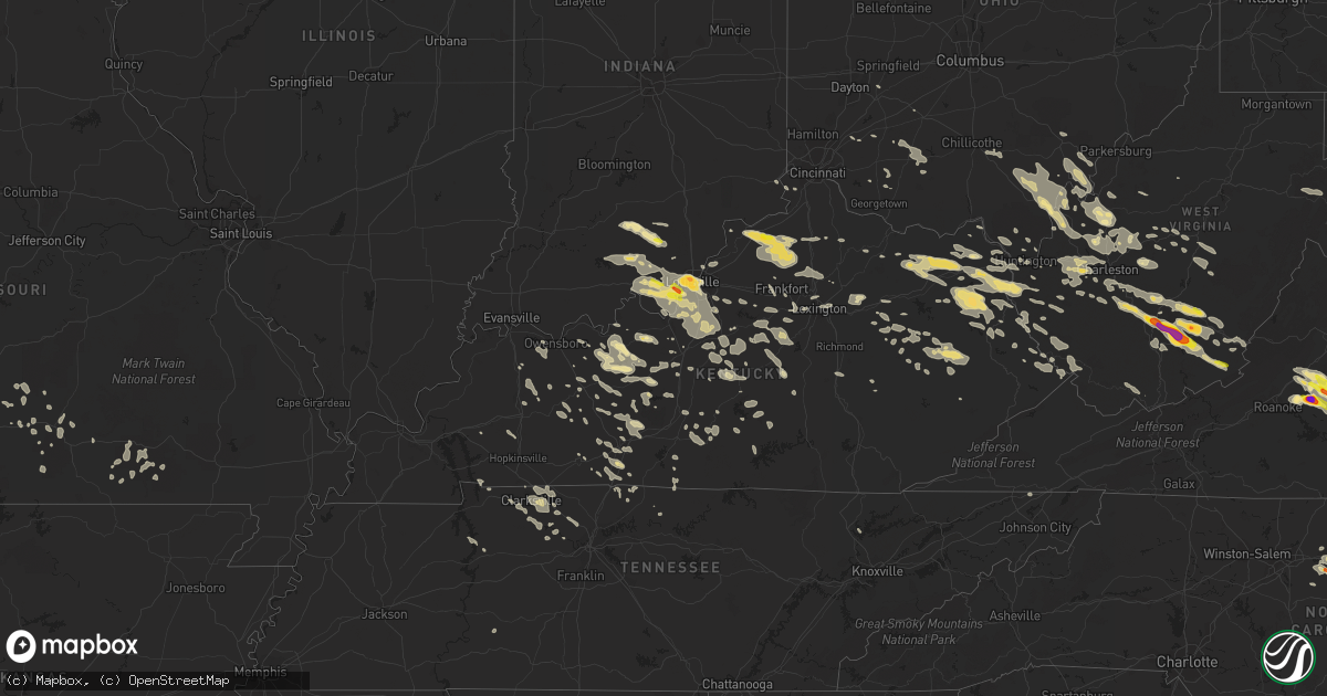
Hail Map in Kentucky on June 23, 2016
Get this storm
June 23 map
$229
one time, instant access
Download today. No call, no setup
Keep the $229
Bought the map and want the full workflow? Apply the entire $229 to a subscription within 7 days. None of it is wasted.
Every map, not just this one
This buys you this map. Subscription and you get every map we run, in the markets you choose from a few cities to whole states to nationwide. Plus real-time alerts the moment a storm fires.
Contact data
Name, contact info, occupancy, even credit band for addresses in the footprint. You go from where it hit to who to call.
Become the source they trust
Unlimited branding weather history reports on demand. You already have the documented answer ready for the property owner, and you are the one who showed up with it.
Property data and RoofTrace estimates
Pull up any address you have got, its value and the exact code rules for that jurisdiction, straight from One Click Code. Then RoofTrace estimates the squares, pitch, and roof value, priced the way you price.
Storm reports in Kentucky
Kentucky
| Date | Description |
|---|---|
| 06/23/20166:50 PM CDT | Trees completely blocking road on hwy 550 between mousie and garrett. |
| 06/23/20166:45 PM CDT | Tree down on hwy 1610. |
| 06/23/20166:45 PM CDT | Tree and power lines fell across a house at virgie. Local fire department was present. No injuries were reported. |
| 06/23/20166:45 PM CDT | Trees reported down. |
| 06/23/20166:40 PM CDT | Trees reported down near the orlando community. Report came in via facebook. |
| 06/23/20166:37 PM CDT | Trees down on sandy ridge road. |
| 06/23/20166:35 PM CDT | Tree down reported from facebook |
| 06/23/20166:30 PM CDT | Delayed report. Trees down near hwy 412. |
| 06/23/20166:28 PM CDT | Large tree down |
| 06/23/20166:25 PM CDT | Trees down. |
| 06/23/20166:20 PM CDT | Trees completely blocking road on hwy 550 between mousie and garrett. |
| 06/23/20166:20 PM CDT | Several trees down from social media |
| 06/23/20166:20 PM CDT | Tree and power lines fell across a house at virgie. Local fire department was present. No injuries were reported. Time based on radar. |
| 06/23/20166:15 PM CDT | Delayed report. Trees down in the area. |
| 06/23/20166:10 PM CDT | Several large limbs at least 6 inches in diameter in yard. |
| 06/23/20166:00 PM CDT | Tree down in creek and large limbs in roadway on hwy 30 east. |
| 06/23/20165:58 PM CDT | Tree down at elementary school. |
| 06/23/20165:55 PM CDT | Delayed report. Trees down in the area. |
| 06/23/20165:48 PM CDT | Delayed report. Trees down in the area. . |
| 06/23/20165:45 PM CDT | Large tree limbs in road on hwy 1010. |
| 06/23/20165:45 PM CDT | Trees down on hwy 746. |
| 06/23/20165:36 PM CDT | Tree knocked down. Time estimated from radar. |
| 06/23/20165:34 PM CDT | Tree knocked down on power line. Time estimated from radar. |
| 06/23/20165:34 PM CDT | Tree knocked down. Time estimated from radar. |
| 06/23/20165:30 PM CDT | Downed tree on hwy 1419. |
| 06/23/20165:30 PM CDT | Multiple trees down on highway 715 social media |
| 06/23/20165:28 PM CDT | Trees down on hwy 302. |
| 06/23/20165:27 PM CDT | Large tree limb blocking utz lane. Time estimated from radar. |
| 06/23/20165:25 PM CDT | Delayed report. Trees down near st paul and elizabethtown rd. |
| 06/23/20165:25 PM CDT | Delayed report. Trees down in the area. |
| 06/23/20165:15 PM CDT | Trees down at kiddville. |
| 06/23/20165:15 PM CDT | Delayed report. Trees down on vaughn road. |
| 06/23/20165:15 PM CDT | Trees down on peter trace road |
| 06/23/20165:15 PM CDT | Trees down at whispering pines. |
| 06/23/20165:15 PM CDT | Trees down in various locations along hwy 715. |
| 06/23/20165:13 PM CDT | Power lines down. |
| 06/23/20165:12 PM CDT | Trees down on hwy 77 on red river road. |
| 06/23/20165:12 PM CDT | Trees down on hwy 1569 |
| 06/23/20165:12 PM CDT | Tree down in bardstown. |
| 06/23/20165:11 PM CDT | Delayed report. Trees down in the area on duff road. |
| 06/23/20165:10 PM CDT | Trees down at the intersection of donaldson and white turkey. Also trees down on chiles hwy. |
| 06/23/20165:10 PM CDT | Trees down at prewitt grassy creek. |
| 06/23/20165:07 PM CDT | Tree blocking old nazareth road. |
| 06/23/20165:00 PM CDT | Trees down. |
| 06/23/20164:50 PM CDT | Tree fell through roof. |
| 06/23/20164:48 PM CDT | Delayed report. Trees down in the area. |
| 06/23/20164:45 PM CDT | Tree down blocking road near rich creek road and route 32 |
| 06/23/20164:41 PM CDT | Trees down on the 4600 block of van thompson road near hwy 537. |
| 06/23/20164:40 PM CDT | Large trees down in bourbon county. |
| 06/23/20164:37 PM CDT | Trees down on donaldson road near the clark county line. |
| 06/23/20164:37 PM CDT | . |
| 06/23/20164:30 PM CDT | Trees down on green briar rd. |
| 06/23/20164:30 PM CDT | . |
| 06/23/20164:20 PM CDT | . |
| 06/23/20164:16 PM CDT | Trees reported down in valley station. |
| 06/23/20164:15 PM CDT | Trees down on donaldson road near the clark county line. |
| 06/23/20164:12 PM CDT | Tree reported down. |
| 06/23/20164:10 PM CDT | Trees down on hwy 706. |
| 06/23/20164:09 PM CDT | Tree down near dundee rd and strathmoor blvd. |
| 06/23/20164:08 PM CDT | Trees down on the 4600 block of van thompson road near hwy 537. |
| 06/23/20164:02 PM CDT | Tree reported down. |
| 06/23/20163:55 PM CDT | Tree down blocking blaine creek road |
| 06/23/20163:39 PM CDT | Trees down between harmony and teresita roads west of georgetown road. From aerial survey by nws louisville. |
| 06/23/20163:25 PM CDT | Trees down on parker road off hwy 111. |
| 06/23/20163:22 PM CDT | Trees and wires down across several roads through the town of grayson. |
| 06/23/20163:20 PM CDT | A few trees down across southern part of the county. |
| 06/23/20163:15 PM CDT | Delayed report. Trees down around port royal. |
| 06/23/20162:36 PM CDT | Tree down along route 2 |
| 06/22/201610:49 PM CDT | Four power poles down on highway 138 west in rumsey. Reported from mclean co. Eoc. |
| 06/22/201610:21 PM CDT | One tree down on greenback road near highway 81. Time radar estimated. Report relayed to daviess county sheriffs office at 1110 pm cdt. |
| 06/22/201610:19 PM CDT | One tree down on vanover road approximately 4.75 miles wnw of utica. Report recieved by from daviess county sheriffs office. At 1046 pm cdt. Event time radar estimated. |
| 06/22/20169:25 PM CDT | Delayed report. Few trees down. |
| 06/22/20169:13 PM CDT | Tree down across highway 31w. |
| 06/22/20168:38 PM CDT | Several trees down in the area. |
| 06/22/20168:35 PM CDT | One tree down on lynnview dr. |
| 06/22/20168:32 PM CDT | Many trees and power lines down. |
| 06/22/20168:32 PM CDT | Many trees and power lines down. |
| 06/22/20167:47 PM CDT | Delayed report. Several trees down around the county. |
| 06/22/20167:37 PM CDT | Trees blocking both lanes of wendover road. Trees down on hurricane creek. Trees down on camp creek rd. |
| 06/22/20167:30 PM CDT | Picture on social media of downed tree. |
| 06/22/20167:30 PM CDT | Trees down. |
| 06/22/20167:15 PM CDT | Trees down on sunshine lane. |
| 06/22/20167:00 PM CDT | Trees down on elk fork bough camp branch. |
All States Impacted by Hail Map on June 23, 2016
Cities Impacted by Hail Map on June 23, 2016
- Java, VA
- Vernon Hill, VA
- Wellington, KS
- Newkirk, OK
- Ponca City, OK
- Wellston, OH
- Bidwell, OH
- Vinton, OH
- Apple Grove, WV
- Southside, WV
- Thurman, OH
- Gallipolis Ferry, WV
- Henderson, WV
- Jackson, OH
- Gallipolis, OH
- Snow Camp, NC
- Graham, NC
- Clarkson, KY
- Bedford, VA
- Thaxton, VA
- Moneta, VA
- Fort Morgan, CO
- Prairie City, SD
- Rustburg, VA
- Goode, VA
- Evington, VA
- Gladys, VA
- Lowry, VA
- Forest, VA
- Lynchburg, VA
- Buffalo, SD
- Reva, SD
- Kinsley, KS
- Garfield, KS
- Dix, NE
- Martha, KY
- Keaton, KY
- East Lynn, WV
- Wayne, WV
- Isonville, KY
- Olive Hill, KY
- Prichard, WV
- Denton, KY
- Wallingford, KY
- Louisa, KY
- Grayson, KY
- Webbville, KY
- Blaine, KY
- Hitchins, KY
- Flemingsburg, KY
- Sitka, KY
- Morehead, KY
- Flatgap, KY
- Catlettsburg, KY
- Genoa, WV
- Fort Gay, WV
- Emerson, KY
- Sandy Hook, KY
- Vanceburg, KY
- Stambaugh, KY
- Rush, KY
- Otis, CO
- Akron, CO
- Rock, KS
- Atlanta, KS
- Douglass, KS
- Pittsburg, KS
- Cherokee, KS
- Weir, KS
- Jetmore, KS
- Fountain Run, KY
- Liberty, NC
- Conway Springs, KS
- Lamar, MO
- Eskdale, WV
- Gallagher, WV
- Montgomery, WV
- Ford, KS
- Belle Plaine, KS
- Sandstone, WV
- Meadow Bridge, WV
- Meadow Creek, WV
- Danese, WV
- Shady Spring, WV
- Bowling Green, KY
- Smiths Grove, KY
- Burrton, KS
- Alderson, WV
- Sinks Grove, WV
- Union, WV
- Wolfcreek, WV
- Bridgeport, NE
- Knob Lick, KY
- Edmonton, KY
- Glasgow, KY
- Bardstown, KY
- Bloomfield, KY
- Ulysses, KY
- Bethpage, TN
- Portland, TN
- South Boston, VA
- Virgilina, VA
- Alton, VA
- Roxboro, NC
- Elizabeth, IN
- Wray, CO
- Elizabethtown, KY
- Longton, KS
- Elk City, KS
- Sedan, KS
- Lodgepole, SD
- Franklin, KY
- Barboursville, WV
- Spring Hope, NC
- Zebulon, NC
- Yates Center, KS
- Merino, CO
- Stoneham, CO
- Hurt, VA
- Gretna, VA
- Medford, OK
- Kenna, WV
- Given, WV
- Liberty, WV
- Victoria, VA
- Chase City, VA
- Bayard, NE
- Morrisville, NC
- Vancleve, KY
- Hazel Green, KY
- Mize, KY
- West Liberty, KY
- Rousseau, KY
- Salyersville, KY
- Cannel City, KY
- Royalton, KY
- Jackson, KY
- Campton, KY
- Pittsboro, NC
- Mullinville, KS
- Hepler, KS
- Uniontown, KS
- Mulberry, KS
- Arma, KS
- Girard, KS
- Arcadia, KS
- Bronaugh, MO
- Walnut, KS
- Fort Scott, KS
- Garland, KS
- Liberal, MO
- Farlington, KS
- Mindenmines, MO
- Radcliff, KY
- Gridley, KS
- Kanawha Falls, WV
- Victor, WV
- Gauley Bridge, WV
- Fayetteville, WV
- Ansted, WV
- Stanton, KY
- Hamlin, WV
- Griffithsville, WV
- Sumerco, WV
- Nitro, WV
- Poca, WV
- Sod, WV
- Winfield, WV
- Alum Creek, WV
- Charleston, WV
- Dunbar, WV
- Scott Depot, WV
- Hurricane, WV
- Saint Albans, WV
- Yawkey, WV
- Culloden, WV
- Milton, WV
- Tornado, WV
- South Charleston, WV
- Hillsboro, OH
- Lynchburg, OH
- Sardinia, OH
- Hutchinson, KS
- Harned, KY
- Sacramento, KY
- Madisonville, KY
- Hanson, KY
- Ash Grove, MO
- Springfield, MO
- Bois D Arc, MO
- Frankfort, KY
- Rockfield, KY
- Morgantown, KY
- Auburn, KY
- Russellville, KY
- Kimball, NE
- Tucumcari, NM
- Washington, NC
- Halifax, VA
- Scottsburg, VA
- Bullock, NC
- Oxford, NC
- Nelson, VA
- Clarksville, VA
- Buffalo Junction, VA
- Henderson, NC
- Dexter, KS
- Beaver, WV
- Asbury, WV
- Oak Hill, WV
- Wayside, WV
- Grassy Meadows, WV
- Scarbro, WV
- Spring Dale, WV
- Hinton, WV
- Orgas, WV
- Gap Mills, WV
- Comfort, WV
- Glen Jean, WV
- Smoot, WV
- Crawley, WV
- Pence Springs, WV
- Thurmond, WV
- Beckley, WV
- Rainelle, WV
- Talcott, WV
- Mount Hope, WV
- Green Sulphur Springs, WV
- Clarksville, TN
- Adams, TN
- Jasper, MO
- Hartville, MO
- Point Pleasant, WV
- Leon, WV
- Benton, KS
- Whitewater, KS
- Potwin, KS
- Blue Ridge, VA
- Vinton, VA
- Aurora, IN
- Falmouth, KY
- Berry, KY
- Cynthiana, KY
- Columbia, KY
- Gradyville, KY
- Greensburg, KY
- Satanta, KS
- Moran, KS
- Duck, WV
- Ivydale, WV
- Caneyville, KY
- Horse Branch, KY
- Moline, KS
- Ripley, WV
- Snyder, CO
- Woodburn, KY
- Keeling, VA
- Semora, NC
- Sutherlin, VA
- Pueblo, CO
- Russell Springs, KY
- Dunnville, KY
- Windsor, KY
- Salvisa, KY
- Harrodsburg, KY
- Canada, KY
- Stone, KY
- Belfry, KY
- Pinsonfork, KY
- Sidney, KY
- Hardy, KY
- Huddy, KY
- Ransom, KY
- McAndrews, KY
- McCarr, KY
- Lewisburg, WV
- Ronceverte, WV
- Longmont, CO
- Mitchell, NE
- Vanzant, MO
- Newton, KS
- Center, CO
- Phenix, VA
- Concord, VA
- Buchanan, VA
- Nathalie, VA
- Brookneal, VA
- Big Island, VA
- Montvale, VA
- Oakland, KY
- Randolph, VA
- Charlotte Court House, VA
- Huddleston, VA
- Xenia, OH
- Yellow Springs, OH
- Falls Of Rough, KY
- Raywick, KY
- Campbellsville, KY
- Peyton, CO
- Elbert, CO
- Saint Francis, KY
- Loretto, KY
- Lebanon, KY
- Cub Run, KY
- Centertown, KY
- New Middletown, IN
- Lanesville, IN
- Corydon, IN
- Louisville, KY
- Geuda Springs, KS
- Burlington, NC
- Stanford, KY
- Springfield, KY
- Mountain Grove, MO
- Hustonville, KY
- Junction City, KY
- Frontenac, KS
- Belton, KY
- Craigsville, WV
- Erie, KS
- Las Vegas, NM
- San Jose, NM
- South Haven, KS
- Lewis, KS
- Belpre, KS
- Sebree, KY
- Riverton, WY
- Madison, KS
- Peabody, KS
- Burns, KS
- Vallonia, IN
- Salem, IN
- Scottsburg, IN
- Mountain View, MO
- Stark, KS
- Smithville, WV
- Clendenin, WV
- Cimarron, KS
- Mescalero, NM
- Taylorsville, KY
- Fisherville, KY
- Harman, WV
- Bowden, WV
- Cassoday, KS
- Ralph, SD
- Ludlow, SD
- Leitchfield, KY
- Portland, OH
- Pomeroy, OH
- Racine, OH
- Long Bottom, OH
- Fredonia, KS
- Nickerson, KS
- Hillsboro, KS
- Scranton, NC
- Belhaven, NC
- Westmoreland, TN
- Paris, KY
- Horse Cave, KY
- Center, KY
- Borden, IN
- Moriarty, NM
- Colorado Springs, CO
- Leasburg, NC
- Argillite, KY
- Ashland, KY
- Greenup, KY
- Flatwoods, KY
- Deerfield, MO
- Oronogo, MO
- Daniels, WV
- McKee, KY
- Tyner, KY
- El Dorado, KS
- Sedgwick, KS
- Towanda, KS
- Valley Center, KS
- Nevada, MO
- Harrisburg, NE
- Sterling, CO
- Pedro, OH
- Asbury, MO
- Opolis, KS
- Louisburg, NC
- Middleburg, NC
- Crystal Hill, VA
- Warrenton, NC
- Manson, NC
- Norlina, NC
- Sapello, NM
- Caldwell, KS
- Sonora, KY
- Upton, KY
- Norwood, MO
- Oxford, KS
- Winfield, KS
- Howard, KS
- Jeffersonville, IN
- Prospect, KY
- Lexington, KY
- Millfield, OH
- Athens, OH
- Scottsville, KY
- Halstead, KS
- Grenola, KS
- Ulysses, KS
- Cherryvale, KS
- Mount Orab, OH
- Williamsburg, OH
- Dodge City, KS
- New Vienna, OH
- Wilmington, OH
- Timberlake, NC
- Sandyville, WV
- Le Roy, WV
- Charmco, WV
- Yuma, CO
- Clarksville, IN
- Fleming, CO
- Peebles, OH
- Bunn, NC
- Braman, OK
- Ezel, KY
- New Hope, KY
- New Haven, KY
- Dupree, SD
- Mayfield, KS
- Argonia, KS
- Milton, KS
- Willow Springs, MO
- Rupert, WV
- Hico, WV
- Lookout, WV
- Nallen, WV
- Quinwood, WV
- Winchester, KY
- Mount Sterling, KY
- Brush, CO
- Scottown, OH
- Willow Wood, OH
- Island, KY
- Central City, KY
- Pinetown, NC
- Cave City, KY
- McDaniels, KY
- New Albany, IN
- Masonic Home, KY
- Versailles, KY
- Lawrenceburg, KY
- Johnson, KS
- Maysel, WV
- Procious, WV
- Wallback, WV
- Clay, WV
- Scottsbluff, NE
- Cheshire, OH
- Mason, WV
- West Columbia, WV
- Buffalo, WV
- Wilkesville, OH
- Rutland, OH
- Fraziers Bottom, WV
- Middleport, OH
- Letart, WV
- Langsville, OH
- Albany, OH
- Chapel Hill, NC
- Niotaze, KS
- Peru, KS
- Pleasant Hope, MO
- Buffalo, MO
- Elkland, MO
- Brighton, MO
- Fair Grove, MO
- Hardinsburg, KY
- Stephensport, KY
- Vine Grove, KY
- Chillicothe, OH
- Ray, OH
- Londonderry, OH
- Wellington, KY
- Slade, KY
- Pine Ridge, KY
- Hartford, KY
- Whitesville, KY
- Walker, MO
- Hanston, KS
- Cabool, MO
- Neodesha, KS
- Garrison, KY
- Lyman, NE
- Bomont, WV
- Walnut Grove, MO
- Campbellsburg, IN
- Orleans, IN
- Ashland City, TN
- White Bluff, TN
- Charlotte, TN
- Elk Creek, MO
- Hudson, KY
- Adams, KY
- Beattyville, KY
- Carthage, MO
- Half Way, MO
- Cedar Point, KS
- Monroe, VA
- Model, CO
- Gay, WV
- Evans, WV
- Paintsville, KY
- River, KY
- Tutor Key, KY
- Boons Camp, KY
- Tomahawk, KY
- Thayer, KS
- Mount Olivet, KY
- Union, KY
- Burlington, KY
- Syracuse, KS
- Kendall, KS
- Wright, KS
- Spearville, KS
- Westview, KY
- Fordsville, KY
- Cloverport, KY
- Morrisville, MO
- Aldrich, MO
- Hartsville, TN
- Dixon Springs, TN
- Larkspur, CO
- Augusta, KS
- El Dorado Springs, MO
- Macomb, MO
- Mansfield, MO
- Big Rock, TN
- Sedan, NM
- Miller, MO
- Waddy, KY
- Walton, KS
- Plato, MO
- Bucyrus, MO
- Reedsville, OH
- Guysville, OH
- Coolville, OH
- Greensburg, KS
- Waverly, TN
- Summersville, WV
- Tioga, WV
- Calvin, WV
- St John, KS
- Stafford, KS
- Minneola, KS
- Larned, KS
- Calhan, CO
- Willisburg, KY
- Chaplin, KY
- Camden On Gauley, WV
- Chatham, VA
- Stem, NC
- Creedmoor, NC
- Franklinton, NC
- Blairs, VA
- Long Island, VA
- Danville, VA
- Ringgold, VA
- Kittrell, NC
- Rougemont, NC
- Depauw, IN
- Chapmansboro, TN
- Bainbridge, OH
- Leesburg, OH
- Edmond, WV
- Garden City, KS
- South Shore, KY
- Birch Tree, MO
- Morrow, OH
- Dora, MO
- Williamson, WV
- Delbarton, WV
- Matewan, WV
- Iliff, CO
- Owensboro, KY
- Utica, KY
- Palmyra, TN
- Woodlawn, TN
- New Liberty, KY
- Worthville, KY
- Sanders, KY
- Owenton, KY
- Glen, WV
- Bedford, KY
- Elon, NC
- Big Sandy, TN
- Partridge, KS
- Peetz, CO
- Reeds, MO
- Avilla, MO
- Ranger, WV
- Spurlockville, WV
- Midkiff, WV
- Owingsville, KY
- Bonnieville, KY
- Munfordville, KY
- Elkview, WV
- Millwood, WV
- Shade, OH
- Bolivar, MO
- Goshen, KY
- Crestwood, KY
- Clarksville, OH
- Blanchester, OH
- Haven, KS
- Polk, MO
- Sterling, KS
- Raymond, KS
- Doniphan, MO
- Mount Vernon, KY
- Berea, KY
- Hesston, KS
- Buhler, KS
- Moundridge, KS
- Brownsville, KY
- Williamsburg, WV
- Marengo, IN
- Hardinsburg, IN
- Milltown, IN
- Paoli, IN
- Mitchell, IN
- Taswell, IN
- French Lick, IN
- Laconia, IN
- Ramsey, IN
- Fredericksburg, IN
- Muldraugh, KY
- English, IN
- Battletown, KY
- Boston, KY
- Greenville, IN
- Lebanon Junction, KY
- West Point, KY
- Coxs Creek, KY
- Floyds Knobs, IN
- Leavenworth, IN
- Palmyra, IN
- Mount Washington, KY
- Shepherdsville, KY
- New Salisbury, IN
- Fairdale, KY
- Brooks, KY
- Clermont, KY
- Georgetown, IN
- Drury, MO
- Left Hand, WV
- Looneyville, WV
- Newton, WV
- Ridgeview, WV
- Costa, WV
- Arkansas City, KS
- Sadieville, KY
- Stamping Ground, KY
- Georgetown, KY
- Buffalo, KY
- Boise City, OK
- Granada, CO
- Pilgrim, KY
- Princeton, KY
- Bucklin, KS
- Turners Station, KY
- Pleasureville, KY
- Campbellsburg, KY
- Perry Park, KY
- Lockport, KY
- Bethlehem, KY
- Carrollton, KY
- Jeffersonville, KY
- Irvington, KY
- Ewing, KY
- Thelma, KY
- Wittensville, KY
- Apex, NC
- Durham, NC
- Cary, NC
- Eckley, CO
- Varney, KY
- Frametown, WV
- Walton, WV
- Cadiz, KY
- Bumpus Mills, TN
- Loma, MT
- Fort Benton, MT
- Scammon, KS
- Jamestown, KY
- Beechmont, KY
- Beech Creek, KY
- Browder, KY
- Drakesboro, KY
- Kiahsville, WV
- Harts, WV
- Reynolds Station, KY
- Nixa, MO
- Rock, WV
- Montcalm, WV
- Clover, VA
- Eagle Butte, SD
- Crook, CO
- Mackville, KY
- Lamar, CO
- Alton, MO
- Crofton, KY
- Frenchburg, KY
- Cecilia, KY
- Eastview, KY
- Glendale, KY
- Big Clifty, KY
- South Williamson, KY
- Cedar Hill, TN
- Golden City, MO
- Matfield Green, KS
- Newell, SD
- Lockwood, MO
- Sylvia, KS
- Corolla, NC
- Rineyville, KY
- Custer, KY
- Glasgow, WV
- Belle, WV
- Smithers, WV
- Mount Carbon, WV
- Handley, WV
- Powellton, WV
- Winifrede, WV
- Hansford, WV
- Pratt, WV
- Lansing, WV
- Robson, WV
- Kimberly, WV
- Hugheston, WV
- Hernshaw, WV
- Cedar Grove, WV
- East Bank, WV
- London, WV
- Winona, MO
- La Follette, TN
- Jacksboro, TN
- Creston, WV
- Garden Plain, KS
- Cheney, KS
- Viola, KS
- Goddard, KS
- Saint Catharine, KY
- Haw River, NC
- Mebane, NC
- Chanute, KS
- Galesburg, KS
- Siler City, NC
- Chloe, WV
- Blanch, NC
- Providence, NC
- Beaver Dam, KY
- Sweeden, KY
- Bee Spring, KY
- Dille, WV
- Birch River, WV
- Huntington, WV
- South Point, OH
- Chesapeake, OH
- Elk Falls, KS
- Hudson, KS
- Alvaton, KY
- Mount Hope, KS
- Salt Lick, KY
- North Middletown, KY
- Shelbyville, KY
- Northfork, WV
- Welch, WV
- Inez, KY
- Warfield, KY
- Dunlow, WV
- Kermit, WV
- Crum, WV
- Guston, KY
- Waynesboro, TN
- Sheldon, MO
- Proctorville, OH
- Julian, WV
- Alkol, WV
- Mud Butte, SD
- Lafayette, TN
- Gamaliel, KY
- Blountville, TN
- Kingsport, TN
- Bremen, KY
- Jetson, KY
- Mount Alto, WV
- Ravenswood, WV
- Cottageville, WV
- Knifley, KY
- Saxe, VA
- Altavista, VA
- Lynch Station, VA
- Red House, VA
- Drakes Branch, VA
- Caldwell, WV
- Salt Rock, WV
- Raton, NM
- Fordland, MO
- Rogersville, MO
- Ozark, MO
- Sparta, MO
- Altoona, KS
- Sandston, VA
- Charles City, VA
- Henrico, VA
- Grandy, NC
- Jarvisburg, NC
- Kitty Hawk, NC
- Webster, KY
- Advent, WV
- Gandeeville, WV
- Amma, WV
- Red House, WV
- Drybranch, WV
- White Sulphur Springs, WV
- Covington, VA
- Pleasant View, TN
- Elk Horn, KY
- Southside, TN
- Cunningham, TN
- Cumberland Furnace, TN
- Clearwater, KS
- Webb City, MO
- Joplin, MO
- Carl Junction, MO
- Udall, KS
- Hardyville, KY
- Inman, KS
- Le Roy, KS
- Omar, WV
- Baisden, WV
- Wharncliffe, WV
- Gilbert, WV
- Cowen, WV
- Little Birch, WV
- Sutton, WV
- Erbacon, WV
- Franktown, CO
- Lamont, OK
- Marionville, MO
- Halltown, MO
- Kitts Hill, OH
- Ironton, OH
- Mammoth Cave, KY
- Casper, WY
- Williamstown, KY
- Corinth, KY
- Lenore, WV
- Fremont, MO
- Mott, ND
- Roundhill, KY
- Wichita, KS
- Maize, KS
- Burlington, KS
- Breeden, WV
- Potter, NE
- Parsons, KS
- La Harpe, KS
- Iola, KS
- Macksville, KS
- Everton, MO
- Hodgenville, KY
- Hollister, NC
- Pekin, IN
- Olaton, KY
- Norwich, KS
- Lizemores, WV
- Bickmore, WV
- Indore, WV
- Rochester, KY
- New Raymer, CO
- Hawesville, KY
- Calhoun, KY
- Washington Court House, OH
- Los Alamos, NM
- Aurora, MO
- Liberty, KY
- Kenova, WV
- Foster, WV
- Seth, WV
- Peytona, WV
- Philpot, KY
- Independence, KS
- Springfield, CO
- La Junta, CO
- Malta, MT
- Nebo, WV
- Falcon, MO
- Grovespring, MO
- Elbing, KS
- Trinidad, CO
- Etoile, KY
- Millwood, KY
- Republic, MO
- Brookline, MO
- Peck, KS
- Perryville, KY
- Parksville, KY
- Danville, KY
- Elkhart, KS
- Joelton, TN
- Springfield, TN
- Leon, KS
- Dalton, NE
- Milo, MO
- Las Animas, CO
- Waukomis, OK
- Boone, CO
- Middleburg, KY
- Kings Mountain, KY
- Carrier, OK
- Emmalena, KY
- Majestic, KY
- Stopover, KY
- Freeburn, KY
- Rogers, KY
- Eureka, KS
- Streator, IL
- Cornell, IL
- Pontiac, IL
- Long Point, IL
- Odell, IL
- Ancona, IL
- Lombard, IL
- Oak Brook, IL
- Clarendon Hills, IL
- Carol Stream, IL
- Glendale Heights, IL
- Hinsdale, IL
- Glen Ellyn, IL
- Wheaton, IL
- Villa Park, IL
- Western Springs, IL
- Westmont, IL
- Elmhurst, IL
- Platteville, CO
- Dowagiac, MI
- Hartford, MI
- Eau Claire, MI
- Benton Harbor, MI
- Saint Joseph, MI


