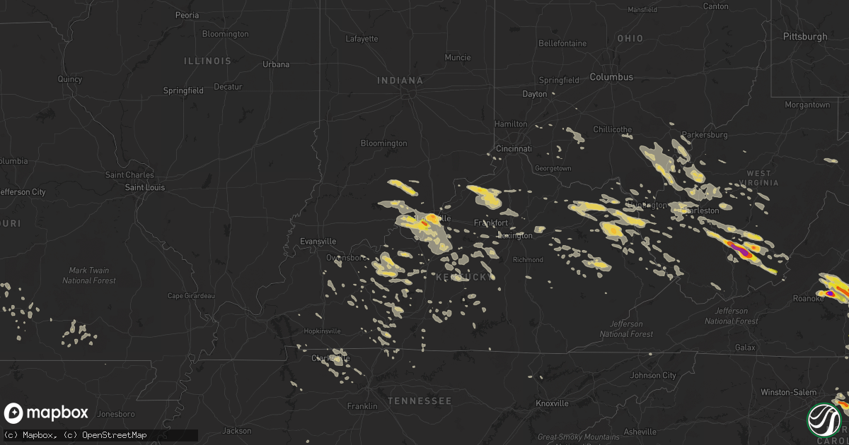
Hail Map on June 23, 2016
Get this storm
June 23 map
$229
one time, instant access
Download today. No call, no setup
Keep the $229
Bought the map and want the full workflow? Apply the entire $229 to a subscription within 7 days. None of it is wasted.
Every map, not just this one
This buys you this map. Subscription and you get every map we run, in the markets you choose from a few cities to whole states to nationwide. Plus real-time alerts the moment a storm fires.
Contact data
Name, contact info, occupancy, even credit band for addresses in the footprint. You go from where it hit to who to call.
Become the source they trust
Unlimited branding weather history reports on demand. You already have the documented answer ready for the property owner, and you are the one who showed up with it.
Property data and RoofTrace estimates
Pull up any address you have got, its value and the exact code rules for that jurisdiction, straight from One Click Code. Then RoofTrace estimates the squares, pitch, and roof value, priced the way you price.
States Impacted by Hail Map on June 23, 2016
Storm reports
Wyoming
| Date | Description |
|---|---|
| 06/22/20169:47 PM CDT | A local report indicates 60 MPH wind near 1 W DOWNTOWN NEWCASTLE |
West Virginia
| Date | Description |
|---|---|
| 06/23/20166:45 PM CDT | Thunderstorm wind caused numerous trees to come down along route 102 within mercer county causing temporary closures on the wv side of the border. |
| 06/23/20166:45 PM CDT | 911 reports of one tree down on falls mill road near bluefield west virginia. |
| 06/23/20166:15 PM CDT | Several trees reported down. Time estimated from radar. |
| 06/23/20165:55 PM CDT | Numerous reports of trees down throughout wyoming county...including route 54. |
| 06/23/20165:45 PM CDT | Trees down |
| 06/23/20165:35 PM CDT | Some trees down... Road blocked. |
| 06/23/20165:35 PM CDT | Trees down in mcgraws. Time estimated from radar. |
| 06/23/20165:25 PM CDT | Trees down along route 85. |
| 06/23/20165:10 PM CDT | Trees down around town. |
| 06/23/20165:08 PM CDT | Trees down... Roads blocked. |
| 06/23/20164:08 PM CDT | Trained spotter reports trees down on auto road near renick west virginia. |
| 06/23/20164:05 PM CDT | Trees down between dunlow and genoa along sr 152 |
| 06/23/20163:15 PM CDT | Public reports quarter size hail near union west virginia. |
| 06/23/20163:08 PM CDT | Numerous trees down. Time estimated from radar. |
| 06/23/20163:04 PM CDT | Tree down at spencer rd and elk river rd n |
| 06/23/20162:57 PM CDT | Four trees down in clendenin |
| 06/23/20162:53 PM CDT | Trees down in ceredo. |
| 06/23/20162:45 PM CDT | Tree down in home brew hollow |
| 06/23/20162:35 PM CDT | Several trees down. |
| 06/23/20162:15 PM CDT | A local report indicates 2.00 inch wind near 2 W MEADOW BRIDGE |
| 06/23/20162:15 PM CDT | A local report indicates 2.00 inch wind near 1 E MEADOW BRIDGE |
| 06/23/20161:58 PM CDT | A local report indicates 1.50 inch wind near OAK HILL |
| 06/23/20161:43 PM CDT | Large limbs down at residence on lick fork run. Time estimated from radar |
| 06/23/20167:42 AM CDT | Large apple tree snapped and fell on a fence...picture found on social media and time estimated by radar. |
| 06/23/20167:42 AM CDT | Trees down in pipestem area. Time radar estimated. |
| 06/23/20167:30 AM CDT | Trees down in the jumping branch area. Time radar estimated. |
| 06/23/20167:30 AM CDT | Trees down along elk knob rd in hinton. Time radar estimated. |
| 06/23/20167:30 AM CDT | One tree blown down by thunderstorm winds on route 12. |
| 06/23/20167:26 AM CDT | Couple of trees blown down on willow wood road. |
| 06/23/20167:25 AM CDT | Tree down across coal city road...corrected for time to 825 am instead of 825 pm |
| 06/23/20167:25 AM CDT | Tree and wires down across east whidby road in shady spring |
| 06/23/20167:24 AM CDT | Multiple trees down along rte 20 north of hinton. Time radar estimated. |
| 06/23/20167:20 AM CDT | One tree blown down by thunderstorm winds. |
| 06/23/20167:20 AM CDT | One tree blown down by thunderstorm winds on route 20. |
| 06/23/20167:15 AM CDT | Tree down across airport road in beaver |
| 06/23/20167:15 AM CDT | Tree across maxwell hill road in beckley |
| 06/23/20167:14 AM CDT | Trees and wires down and fell on two cars parked in a driveway. Damage picture found on social media and report estimated by radar. |
| 06/23/20167:05 AM CDT | Tree and wires down across peach tree road in naoma |
| 06/22/20167:25 PM CDT | Tree down across coal city road |
Virginia
| Date | Description |
|---|---|
| 06/23/20166:52 PM CDT | Thunderstorm winds caused numerous trees to fall along route 102 in tazewell county va. |
| 06/23/20166:42 PM CDT | 911 reports of a tree down on cumberland road near narrows virginia. |
| 06/23/20166:39 PM CDT | Thunderstorm winds caused two trees to fall near the intersection of river road and birch elmo roads in halifax county... Va. |
| 06/23/20166:30 PM CDT | Thunderstorm wind took down numerous trees and powerpoles in the rich creek area of giles county... Va. |
| 06/23/20166:14 PM CDT | Public reports of baseball size hail on hwy 501 just north of the virginia north carolina border. |
| 06/23/20166:03 PM CDT | Numerous trees and large limbs down. Time from radar. |
| 06/23/20166:03 PM CDT | Public reports several large tree limbs down on watlington road near mt airy virginia. |
| 06/23/20166:03 PM CDT | Broadcast media station forwarded a report of baseball size hail that fell in alton va. |
| 06/23/20165:30 PM CDT | Tree down blocking road. |
| 06/23/20165:10 PM CDT | Several minutes of one to two inch hail with a few baseball size hailstones on magnola drive.cars damaged. |
| 06/23/20165:10 PM CDT | 1 inch hail on wheatland road |
| 06/23/20165:09 PM CDT | Thunderstorm winds caused the downing of two trees near the intersection of bill tuck highway and aarons creek road in halifax county... Va. |
| 06/23/20164:58 PM CDT | Thunderstorm winds caused a tree to fall across james c. Hagood road in halifax county... Va. |
| 06/23/20164:58 PM CDT | Public reports quarter size hail at the exxon gas station in scottsburg virginia. |
| 06/23/20164:29 PM CDT | Thunderstorm winds brought down several trees in the phoenix area. |
| 06/23/20163:34 PM CDT | Thunderstorm produced hail the size of quarters near rustburg. |
| 06/23/20163:32 PM CDT | A local report indicates 1.50 inch wind near RUSTBURG |
| 06/23/20163:30 PM CDT | Tree down clarkes road |
| 06/23/20163:20 PM CDT | Public reports ping pong size hail in forest virginia. |
| 06/23/20163:17 PM CDT | Spotters reported golf ball size hail near forest virginia. |
| 06/23/20163:15 PM CDT | Public reports of golfball size hail southwest of lynchburg virginia. |
| 06/23/20163:10 PM CDT | Spotter reports golf ball size hail in forest virginia. |
| 06/23/20163:10 PM CDT | Public reports quarter size hail near forest virginia. |
| 06/23/20163:02 PM CDT | Public reports of quarter size hail near goode virginia. |
| 06/23/20163:00 PM CDT | A local report indicates 1.00 inch wind near GOODE |
| 06/23/20162:50 PM CDT | Broadcast media relays report of snapped trees along big island hwy. |
| 06/23/20162:22 PM CDT | Public reports of large trees down by yellow branch elementary school near evington virginia. |
| 06/23/20168:24 AM CDT | Tree down on hunting hills blvd near rte 220. Time radar estimated. |
| 06/23/20168:12 AM CDT | Tree down on historic dr. Time radar estimated. |
| 06/23/20168:12 AM CDT | Tree down blocking road at 1600 block of templeton. Time radar estimated. |
| 06/23/20168:10 AM CDT | Tree reported down along rte 460 approx 3-4 miles outside of pembroke. Time radar extimated. |
| 06/23/20168:10 AM CDT | Large tree down. Broke an antenna. |
| 06/23/20167:42 AM CDT | Four to five trees reported down across the road in the crows area. Time estimated from radar. |
| 06/23/20167:19 AM CDT | Trees down along stergeon pt road in charles city county. |
| 06/23/20167:10 AM CDT | 2 trees downed along va-600. |
| 06/22/20168:51 PM CDT | Thunderstorm winds brought down one tree within the community of hillsville. |
| 06/22/20168:20 PM CDT | 2 trees down - one on town branch rd and another at hether springs |
| 06/22/20168:01 PM CDT | Thunderstorm winds resulted in numerous trees and powerpoles down in the adwolf portion of smyth county... Va. Time based on radar. |
| 06/22/20167:50 PM CDT | Multiple trees down countywide ranging from around 850 pm to around 10 pm |
| 06/22/20167:45 PM CDT | One tree blown down by thunderstorm winds on route 42. |
| 06/22/20167:34 PM CDT | Thunderstorm winds blew down one tree near the draper valley overlook. |
| 06/22/20167:30 PM CDT | 1 tree down east of honaker |
| 06/22/20167:20 PM CDT | Trees down in southern buchanan county. Time estimated from radar. |
| 06/22/20167:17 PM CDT | Roof blown off the binns-counts community center. |
| 06/22/20167:15 PM CDT | Thunderstorm winds brought down multiple trees just west of bluefield virginia. |
| 06/22/20167:01 PM CDT | Four trees reported down along route 609 in harman. |
| 06/22/20167:00 PM CDT | Numerous reports of trees down in haysi and throughout dickenson county. |
Colorado
| Date | Description |
|---|---|
| 06/23/20166:40 PM CDT | A local report indicates 60 MPH wind near 1 N STRASBURG |
| 06/23/20166:34 PM CDT | A local report indicates 1.00 inch wind near 4 WSW WILLARD |
| 06/23/20166:34 PM CDT | A local report indicates 1.00 inch wind near 16 NW MERINO |
| 06/23/20166:05 PM CDT | A local report indicates 1.50 inch wind near 3 NNW PAWNEE PASS |
| 06/23/20165:45 PM CDT | 80 mph winds which destroyed 2 outbuildings |
| 06/23/20163:11 PM CDT | . |
| 06/22/20168:30 PM CDT | One to two foot diameter trees down on us 40. Time estimated from radar. |
| 06/22/20168:30 PM CDT | Numerous large trees down. Wind speed unknown. Time estimated from radar. |
| 06/22/20167:55 PM CDT | Awos station hayden airport /hdn/ corrected for thunderstorm wind gust. |
| 06/22/20167:43 PM CDT | 20 feet long limb down with 3.5 inch diameter. 70 mph estimated wind gust. |
| 06/22/20167:37 PM CDT | A local report indicates 60 MPH wind near 3 N CROOK |
| 06/22/20167:31 PM CDT | A local report indicates 60 MPH wind near CROOK |
| 06/22/20167:24 PM CDT | Asos station craig - moffat county airport /cag/. |
| 06/22/20167:21 PM CDT | Trees upto 13 inch diameter snapped or uprooted. Downed power lines resulted in power outage for one hour. |
| 06/22/20167:15 PM CDT | 20 feet long limb down with 3.5 inch diameter. 70 mph estimated wind gust. |
Missouri
| Date | Description |
|---|---|
| 06/23/20166:51 PM CDT | Tree down in yard. |
| 06/22/20169:13 PM CDT | Power lines down from northeast polk county into louisburg and tunas areas in dallas county |
| 06/22/20168:47 PM CDT | Polk county 911 reports trees down north of bolivar near county roads s122 and e418. |
| 06/22/20167:35 PM CDT | Public reported large tree limbs down on a home in bronaugh. Report relayed via usps. Time estimated by radar. |
| 06/22/20167:25 PM CDT | Tree down near sw springfield. |
| 06/22/20167:20 PM CDT | Several trees down apprx 2 ft in diameter near reed rd and 125 near sparta. |
| 06/22/20167:20 PM CDT | Tree down in yard. |
| 06/22/20167:10 PM CDT | Corrected for time and location...several trees down apprx 2 ft in diameter near reed rd and 125 near sparta. |
Kansas
| Date | Description |
|---|---|
| 06/23/20166:51 PM CDT | Tree down on 560th 1/2 mile west of pittsburgh. Blocking roadway. |
| 06/23/20166:51 PM CDT | Delayed report from twitter of a gas station canopy blown over at the stockyard travel plaza. Time radar estimated. |
| 06/23/20166:42 PM CDT | Large tree in road 1/4 mile north of 20th and 210 ave. |
| 06/23/20166:24 PM CDT | 2 small trees uprooted |
| 06/23/20166:10 PM CDT | Two telephone poles were reported downed in the pittsburg area. |
| 06/23/20164:00 PM CDT | Delayed report of a large tree snapped with multiple large limbs broken and corn laid over in the area. |
| 06/23/20162:40 PM CDT | Amateur radio reports the top 15 feet of an elm tree was brought down due to strong winds. Time is an approximation from radar. |
| 06/22/201610:16 PM CDT | . |
| 06/22/20167:26 PM CDT | Public reported large tree limb down at pittsburg state university via social media. Time estimated by radar. |
| 06/22/20167:20 PM CDT | Carport in roadway near 852 n 250th near arcadia. |
Kentucky
| Date | Description |
|---|---|
| 06/23/20166:50 PM CDT | Trees completely blocking road on hwy 550 between mousie and garrett. |
| 06/23/20166:45 PM CDT | Tree down on hwy 1610. |
| 06/23/20166:45 PM CDT | Trees reported down. |
| 06/23/20166:45 PM CDT | Tree and power lines fell across a house at virgie. Local fire department was present. No injuries were reported. |
| 06/23/20166:40 PM CDT | Trees reported down near the orlando community. Report came in via facebook. |
| 06/23/20166:37 PM CDT | Trees down on sandy ridge road. |
| 06/23/20166:35 PM CDT | Tree down reported from facebook |
| 06/23/20166:30 PM CDT | Delayed report. Trees down near hwy 412. |
| 06/23/20166:28 PM CDT | Large tree down |
| 06/23/20166:25 PM CDT | Trees down. |
| 06/23/20166:20 PM CDT | Several trees down from social media |
| 06/23/20166:20 PM CDT | Tree and power lines fell across a house at virgie. Local fire department was present. No injuries were reported. Time based on radar. |
| 06/23/20166:20 PM CDT | Trees completely blocking road on hwy 550 between mousie and garrett. |
| 06/23/20166:15 PM CDT | Delayed report. Trees down in the area. |
| 06/23/20166:10 PM CDT | Several large limbs at least 6 inches in diameter in yard. |
| 06/23/20166:00 PM CDT | Tree down in creek and large limbs in roadway on hwy 30 east. |
| 06/23/20165:58 PM CDT | Tree down at elementary school. |
| 06/23/20165:55 PM CDT | Delayed report. Trees down in the area. |
| 06/23/20165:48 PM CDT | Delayed report. Trees down in the area. . |
| 06/23/20165:45 PM CDT | Trees down on hwy 746. |
| 06/23/20165:45 PM CDT | Large tree limbs in road on hwy 1010. |
| 06/23/20165:36 PM CDT | Tree knocked down. Time estimated from radar. |
| 06/23/20165:34 PM CDT | Tree knocked down. Time estimated from radar. |
| 06/23/20165:34 PM CDT | Tree knocked down on power line. Time estimated from radar. |
| 06/23/20165:30 PM CDT | Multiple trees down on highway 715 social media |
| 06/23/20165:30 PM CDT | Downed tree on hwy 1419. |
| 06/23/20165:28 PM CDT | Trees down on hwy 302. |
| 06/23/20165:27 PM CDT | Large tree limb blocking utz lane. Time estimated from radar. |
| 06/23/20165:25 PM CDT | Delayed report. Trees down near st paul and elizabethtown rd. |
| 06/23/20165:25 PM CDT | Delayed report. Trees down in the area. |
| 06/23/20165:15 PM CDT | Trees down on peter trace road |
| 06/23/20165:15 PM CDT | Trees down at kiddville. |
| 06/23/20165:15 PM CDT | Delayed report. Trees down on vaughn road. |
| 06/23/20165:15 PM CDT | Trees down at whispering pines. |
| 06/23/20165:15 PM CDT | Trees down in various locations along hwy 715. |
| 06/23/20165:13 PM CDT | Power lines down. |
| 06/23/20165:12 PM CDT | Tree down in bardstown. |
| 06/23/20165:12 PM CDT | Trees down on hwy 77 on red river road. |
| 06/23/20165:12 PM CDT | Trees down on hwy 1569 |
| 06/23/20165:11 PM CDT | Delayed report. Trees down in the area on duff road. |
| 06/23/20165:10 PM CDT | Trees down at the intersection of donaldson and white turkey. Also trees down on chiles hwy. |
| 06/23/20165:10 PM CDT | Trees down at prewitt grassy creek. |
| 06/23/20165:07 PM CDT | Tree blocking old nazareth road. |
| 06/23/20165:00 PM CDT | Trees down. |
| 06/23/20164:50 PM CDT | Tree fell through roof. |
| 06/23/20164:48 PM CDT | Delayed report. Trees down in the area. |
| 06/23/20164:45 PM CDT | Tree down blocking road near rich creek road and route 32 |
| 06/23/20164:41 PM CDT | Trees down on the 4600 block of van thompson road near hwy 537. |
| 06/23/20164:40 PM CDT | Large trees down in bourbon county. |
| 06/23/20164:37 PM CDT | Trees down on donaldson road near the clark county line. |
| 06/23/20164:37 PM CDT | . |
| 06/23/20164:30 PM CDT | Trees down on green briar rd. |
| 06/23/20164:30 PM CDT | . |
| 06/23/20164:20 PM CDT | . |
| 06/23/20164:16 PM CDT | Trees reported down in valley station. |
| 06/23/20164:15 PM CDT | Trees down on donaldson road near the clark county line. |
| 06/23/20164:12 PM CDT | Tree reported down. |
| 06/23/20164:10 PM CDT | Trees down on hwy 706. |
| 06/23/20164:09 PM CDT | Tree down near dundee rd and strathmoor blvd. |
| 06/23/20164:08 PM CDT | Trees down on the 4600 block of van thompson road near hwy 537. |
| 06/23/20164:02 PM CDT | Tree reported down. |
| 06/23/20163:55 PM CDT | Tree down blocking blaine creek road |
| 06/23/20163:39 PM CDT | Trees down between harmony and teresita roads west of georgetown road. From aerial survey by nws louisville. |
| 06/23/20163:25 PM CDT | Trees down on parker road off hwy 111. |
| 06/23/20163:22 PM CDT | Trees and wires down across several roads through the town of grayson. |
| 06/23/20163:20 PM CDT | A few trees down across southern part of the county. |
| 06/23/20163:15 PM CDT | Delayed report. Trees down around port royal. |
| 06/23/20162:36 PM CDT | Tree down along route 2 |
| 06/22/201610:49 PM CDT | Four power poles down on highway 138 west in rumsey. Reported from mclean co. Eoc. |
| 06/22/201610:21 PM CDT | One tree down on greenback road near highway 81. Time radar estimated. Report relayed to daviess county sheriffs office at 1110 pm cdt. |
| 06/22/201610:19 PM CDT | One tree down on vanover road approximately 4.75 miles wnw of utica. Report recieved by from daviess county sheriffs office. At 1046 pm cdt. Event time radar estimated. |
| 06/22/20169:25 PM CDT | Delayed report. Few trees down. |
| 06/22/20169:13 PM CDT | Tree down across highway 31w. |
| 06/22/20168:38 PM CDT | Several trees down in the area. |
| 06/22/20168:35 PM CDT | One tree down on lynnview dr. |
| 06/22/20168:32 PM CDT | Many trees and power lines down. |
| 06/22/20168:32 PM CDT | Many trees and power lines down. |
| 06/22/20167:47 PM CDT | Delayed report. Several trees down around the county. |
| 06/22/20167:37 PM CDT | Trees blocking both lanes of wendover road. Trees down on hurricane creek. Trees down on camp creek rd. |
| 06/22/20167:30 PM CDT | Picture on social media of downed tree. |
| 06/22/20167:30 PM CDT | Trees down. |
| 06/22/20167:15 PM CDT | Trees down on sunshine lane. |
| 06/22/20167:00 PM CDT | Trees down on elk fork bough camp branch. |
Ohio
| Date | Description |
|---|---|
| 06/23/20165:40 PM CDT | Hail at least quarter size...picture on social media appears that hail may have been half dollar to ping pong ball sized hail. |
| 06/23/20164:53 PM CDT | Tree knocked down across chesnut road. Time estimated from radar. |
| 06/23/20164:45 PM CDT | Trees downed on power lines. Denver road outside of waverly. Time estimated by radar. |
| 06/23/20164:35 PM CDT | Trees down in chester |
| 06/23/20169:29 AM CDT | Numerous large trees snapped at bush road cemetary... As well as limbs scattered throughout the area. |
Oklahoma
| Date | Description |
|---|---|
| 06/23/20162:50 PM CDT | Relayed via wfo ict. |
| 06/23/20163:06 AM CDT | Three power poles snapped by high wind. |
Indiana
| Date | Description |
|---|---|
| 06/23/20164:35 PM CDT | . |
| 06/23/20163:51 PM CDT | . |
| 06/23/20162:43 PM CDT | Large tree limbs down... |
| 06/23/20168:00 AM CDT | 6 to 7 electric poles in a row snapped in half or tilted. Time estimated. |
Tennessee
| Date | Description |
|---|---|
| 06/23/20168:35 AM CDT | A few trees down in the black valley area near highway 33 and highway 31. |
| 06/23/20163:42 AM CDT | Facebook image shows a tree down across toll gate rd. Event time was radar estimated. |
| 06/23/20162:45 AM CDT | Several trees downed across county. |
| 06/23/201612:34 AM CDT | Treee on a house at 1105 38th avenue north. |
| 06/23/201612:10 AM CDT | Pictures from a tspotter report shows trees down and large limbs broken on a farm. |
| 06/23/201612:10 AM CDT | A few trees down in carthage |
| 06/23/201612:07 AM CDT | A few trees down across knox county. |
| 06/22/201611:56 PM CDT | Tree damage in the springbrook neighborhood. Event time was radar estimated. |
| 06/22/20169:45 PM CDT | Multiple trees down along hwy 116 - report came in around 1045 to 1055 pm |
| 06/22/20169:33 PM CDT | A few trees down in the jamestown area. |
| 06/22/20169:11 PM CDT | 2 trees down - 1 in kingsport at 1011pm and 1 closer to piney flats reported at 1021pm |
| 06/22/20168:35 PM CDT | Corrected for time...a few trees down in the black valley area near highway 33 and highway 31. |
South Dakota
| Date | Description |
|---|---|
| 06/23/201612:58 AM CDT | A local report indicates 1.75 inch wind near 11 NNW PRAIRIE CITY |
North Carolina
| Date | Description |
|---|---|
| 06/23/20166:55 PM CDT | Thunderstorm winds caused a 12 - 15 inch pine to topple down east of yanceyville in nc. |
| 06/23/20166:50 PM CDT | . |
| 06/23/20166:40 PM CDT | . |
| 06/23/20166:25 PM CDT | Tree down on i-85 near exit 220. . |
| 06/23/20166:24 PM CDT | Report on u.s. Route 501 just south of va state line. . |
| 06/23/20166:14 PM CDT | Public reports of baseball size hail on hwy 501 just north of the virginia north carolina border. |
| 06/23/20166:12 PM CDT | . |
| 06/23/20165:45 PM CDT | . |
| 06/23/20165:25 PM CDT | . |
| 06/23/20164:33 PM CDT | . |
| 06/23/201610:00 AM CDT | Very large tree down on house left it uninhabitable |
| 06/22/201610:45 PM CDT | Tree fell on house off forestdale drive in salisbury... Nc. |
| 06/22/20169:02 PM CDT | Thunderstorm winds brought down numerous trees in the community of ennice in alleghany county... Nc. |
| 06/22/20168:50 PM CDT | Several trees reported down at mcdowell and fayetteville st and zoo parkway. Power outages in and around asheboro. |
| 06/22/20167:40 PM CDT | Tree down at heritage lake road and route 98. |
| 06/22/20167:35 PM CDT | Tree down on pixley pritchard road at thomas store road. |
| 06/22/20167:30 PM CDT | Multiple trees down in louisburg and bunn. . |
| 06/22/20167:30 PM CDT | Tree down on todd road. . |
| 06/22/20167:30 PM CDT | Large tree down on appaloosa run east at shooting club road. |
| 06/22/20167:25 PM CDT | . |
| 06/22/20167:20 PM CDT | Thunderstorm winds resulted in numerous trees down along us 158 in the far eastern portions of caswell county in nc. |
New Mexico
| Date | Description |
|---|---|
| 06/23/20164:23 PM CDT | Mostly nickel size hail but occasionally quarter size. |
Cities Impacted by Hail Map on June 23, 2016
- Java, VA
- Vernon Hill, VA
- Wellington, KS
- Newkirk, OK
- Ponca City, OK
- Wellston, OH
- Bidwell, OH
- Vinton, OH
- Apple Grove, WV
- Southside, WV
- Thurman, OH
- Gallipolis Ferry, WV
- Henderson, WV
- Jackson, OH
- Gallipolis, OH
- Snow Camp, NC
- Graham, NC
- Clarkson, KY
- Bedford, VA
- Thaxton, VA
- Moneta, VA
- Fort Morgan, CO
- Prairie City, SD
- Rustburg, VA
- Goode, VA
- Evington, VA
- Gladys, VA
- Lowry, VA
- Forest, VA
- Lynchburg, VA
- Buffalo, SD
- Reva, SD
- Kinsley, KS
- Garfield, KS
- Dix, NE
- Martha, KY
- Keaton, KY
- East Lynn, WV
- Wayne, WV
- Isonville, KY
- Olive Hill, KY
- Prichard, WV
- Denton, KY
- Wallingford, KY
- Louisa, KY
- Grayson, KY
- Webbville, KY
- Blaine, KY
- Hitchins, KY
- Flemingsburg, KY
- Sitka, KY
- Morehead, KY
- Flatgap, KY
- Catlettsburg, KY
- Genoa, WV
- Fort Gay, WV
- Emerson, KY
- Sandy Hook, KY
- Vanceburg, KY
- Stambaugh, KY
- Rush, KY
- Otis, CO
- Akron, CO
- Rock, KS
- Atlanta, KS
- Douglass, KS
- Pittsburg, KS
- Cherokee, KS
- Weir, KS
- Jetmore, KS
- Fountain Run, KY
- Liberty, NC
- Conway Springs, KS
- Lamar, MO
- Eskdale, WV
- Gallagher, WV
- Montgomery, WV
- Ford, KS
- Belle Plaine, KS
- Sandstone, WV
- Meadow Bridge, WV
- Meadow Creek, WV
- Danese, WV
- Shady Spring, WV
- Bowling Green, KY
- Smiths Grove, KY
- Burrton, KS
- Alderson, WV
- Sinks Grove, WV
- Union, WV
- Wolfcreek, WV
- Bridgeport, NE
- Knob Lick, KY
- Edmonton, KY
- Glasgow, KY
- Bardstown, KY
- Bloomfield, KY
- Ulysses, KY
- Bethpage, TN
- Portland, TN
- South Boston, VA
- Virgilina, VA
- Alton, VA
- Roxboro, NC
- Elizabeth, IN
- Wray, CO
- Elizabethtown, KY
- Longton, KS
- Elk City, KS
- Sedan, KS
- Lodgepole, SD
- Franklin, KY
- Barboursville, WV
- Spring Hope, NC
- Zebulon, NC
- Yates Center, KS
- Merino, CO
- Stoneham, CO
- Hurt, VA
- Gretna, VA
- Medford, OK
- Kenna, WV
- Given, WV
- Liberty, WV
- Victoria, VA
- Chase City, VA
- Bayard, NE
- Morrisville, NC
- Vancleve, KY
- Hazel Green, KY
- Mize, KY
- West Liberty, KY
- Rousseau, KY
- Salyersville, KY
- Cannel City, KY
- Royalton, KY
- Jackson, KY
- Campton, KY
- Pittsboro, NC
- Mullinville, KS
- Hepler, KS
- Uniontown, KS
- Mulberry, KS
- Arma, KS
- Girard, KS
- Arcadia, KS
- Bronaugh, MO
- Walnut, KS
- Fort Scott, KS
- Garland, KS
- Liberal, MO
- Farlington, KS
- Mindenmines, MO
- Radcliff, KY
- Gridley, KS
- Kanawha Falls, WV
- Victor, WV
- Gauley Bridge, WV
- Fayetteville, WV
- Ansted, WV
- Stanton, KY
- Hamlin, WV
- Griffithsville, WV
- Sumerco, WV
- Nitro, WV
- Poca, WV
- Sod, WV
- Winfield, WV
- Alum Creek, WV
- Charleston, WV
- Dunbar, WV
- Scott Depot, WV
- Hurricane, WV
- Saint Albans, WV
- Yawkey, WV
- Culloden, WV
- Milton, WV
- Tornado, WV
- South Charleston, WV
- Hillsboro, OH
- Lynchburg, OH
- Sardinia, OH
- Hutchinson, KS
- Harned, KY
- Sacramento, KY
- Madisonville, KY
- Hanson, KY
- Ash Grove, MO
- Springfield, MO
- Bois D Arc, MO
- Frankfort, KY
- Rockfield, KY
- Morgantown, KY
- Auburn, KY
- Russellville, KY
- Kimball, NE
- Tucumcari, NM
- Washington, NC
- Halifax, VA
- Scottsburg, VA
- Bullock, NC
- Oxford, NC
- Nelson, VA
- Clarksville, VA
- Buffalo Junction, VA
- Henderson, NC
- Dexter, KS
- Beaver, WV
- Asbury, WV
- Oak Hill, WV
- Wayside, WV
- Grassy Meadows, WV
- Scarbro, WV
- Spring Dale, WV
- Hinton, WV
- Orgas, WV
- Gap Mills, WV
- Comfort, WV
- Glen Jean, WV
- Smoot, WV
- Crawley, WV
- Pence Springs, WV
- Thurmond, WV
- Beckley, WV
- Rainelle, WV
- Talcott, WV
- Mount Hope, WV
- Green Sulphur Springs, WV
- Clarksville, TN
- Adams, TN
- Jasper, MO
- Hartville, MO
- Point Pleasant, WV
- Leon, WV
- Benton, KS
- Whitewater, KS
- Potwin, KS
- Blue Ridge, VA
- Vinton, VA
- Aurora, IN
- Falmouth, KY
- Berry, KY
- Cynthiana, KY
- Columbia, KY
- Gradyville, KY
- Greensburg, KY
- Satanta, KS
- Moran, KS
- Duck, WV
- Ivydale, WV
- Caneyville, KY
- Horse Branch, KY
- Moline, KS
- Ripley, WV
- Snyder, CO
- Woodburn, KY
- Keeling, VA
- Semora, NC
- Sutherlin, VA
- Pueblo, CO
- Russell Springs, KY
- Dunnville, KY
- Windsor, KY
- Salvisa, KY
- Harrodsburg, KY
- Canada, KY
- Stone, KY
- Belfry, KY
- Pinsonfork, KY
- Sidney, KY
- Hardy, KY
- Huddy, KY
- Ransom, KY
- McAndrews, KY
- McCarr, KY
- Lewisburg, WV
- Ronceverte, WV
- Longmont, CO
- Mitchell, NE
- Vanzant, MO
- Newton, KS
- Center, CO
- Phenix, VA
- Concord, VA
- Buchanan, VA
- Nathalie, VA
- Brookneal, VA
- Big Island, VA
- Montvale, VA
- Oakland, KY
- Randolph, VA
- Charlotte Court House, VA
- Huddleston, VA
- Xenia, OH
- Yellow Springs, OH
- Falls Of Rough, KY
- Raywick, KY
- Campbellsville, KY
- Peyton, CO
- Elbert, CO
- Saint Francis, KY
- Loretto, KY
- Lebanon, KY
- Cub Run, KY
- Centertown, KY
- New Middletown, IN
- Lanesville, IN
- Corydon, IN
- Louisville, KY
- Geuda Springs, KS
- Burlington, NC
- Stanford, KY
- Springfield, KY
- Mountain Grove, MO
- Hustonville, KY
- Junction City, KY
- Frontenac, KS
- Belton, KY
- Craigsville, WV
- Erie, KS
- Las Vegas, NM
- San Jose, NM
- South Haven, KS
- Lewis, KS
- Belpre, KS
- Sebree, KY
- Riverton, WY
- Madison, KS
- Peabody, KS
- Burns, KS
- Vallonia, IN
- Salem, IN
- Scottsburg, IN
- Mountain View, MO
- Stark, KS
- Smithville, WV
- Clendenin, WV
- Cimarron, KS
- Mescalero, NM
- Taylorsville, KY
- Fisherville, KY
- Harman, WV
- Bowden, WV
- Cassoday, KS
- Ralph, SD
- Ludlow, SD
- Leitchfield, KY
- Portland, OH
- Pomeroy, OH
- Racine, OH
- Long Bottom, OH
- Fredonia, KS
- Nickerson, KS
- Hillsboro, KS
- Scranton, NC
- Belhaven, NC
- Westmoreland, TN
- Paris, KY
- Horse Cave, KY
- Center, KY
- Borden, IN
- Moriarty, NM
- Colorado Springs, CO
- Leasburg, NC
- Argillite, KY
- Ashland, KY
- Greenup, KY
- Flatwoods, KY
- Deerfield, MO
- Oronogo, MO
- Daniels, WV
- McKee, KY
- Tyner, KY
- El Dorado, KS
- Sedgwick, KS
- Towanda, KS
- Valley Center, KS
- Nevada, MO
- Harrisburg, NE
- Sterling, CO
- Pedro, OH
- Asbury, MO
- Opolis, KS
- Louisburg, NC
- Middleburg, NC
- Crystal Hill, VA
- Warrenton, NC
- Manson, NC
- Norlina, NC
- Sapello, NM
- Caldwell, KS
- Sonora, KY
- Upton, KY
- Norwood, MO
- Oxford, KS
- Winfield, KS
- Howard, KS
- Jeffersonville, IN
- Prospect, KY
- Lexington, KY
- Millfield, OH
- Athens, OH
- Scottsville, KY
- Halstead, KS
- Grenola, KS
- Ulysses, KS
- Cherryvale, KS
- Mount Orab, OH
- Williamsburg, OH
- Dodge City, KS
- New Vienna, OH
- Wilmington, OH
- Timberlake, NC
- Sandyville, WV
- Le Roy, WV
- Charmco, WV
- Yuma, CO
- Clarksville, IN
- Fleming, CO
- Peebles, OH
- Bunn, NC
- Braman, OK
- Ezel, KY
- New Hope, KY
- New Haven, KY
- Dupree, SD
- Mayfield, KS
- Argonia, KS
- Milton, KS
- Willow Springs, MO
- Rupert, WV
- Hico, WV
- Lookout, WV
- Nallen, WV
- Quinwood, WV
- Winchester, KY
- Mount Sterling, KY
- Brush, CO
- Scottown, OH
- Willow Wood, OH
- Island, KY
- Central City, KY
- Pinetown, NC
- Cave City, KY
- McDaniels, KY
- New Albany, IN
- Masonic Home, KY
- Versailles, KY
- Lawrenceburg, KY
- Johnson, KS
- Maysel, WV
- Procious, WV
- Wallback, WV
- Clay, WV
- Scottsbluff, NE
- Cheshire, OH
- Mason, WV
- West Columbia, WV
- Buffalo, WV
- Wilkesville, OH
- Rutland, OH
- Fraziers Bottom, WV
- Middleport, OH
- Letart, WV
- Langsville, OH
- Albany, OH
- Chapel Hill, NC
- Niotaze, KS
- Peru, KS
- Pleasant Hope, MO
- Buffalo, MO
- Elkland, MO
- Brighton, MO
- Fair Grove, MO
- Hardinsburg, KY
- Stephensport, KY
- Vine Grove, KY
- Chillicothe, OH
- Ray, OH
- Londonderry, OH
- Wellington, KY
- Slade, KY
- Pine Ridge, KY
- Hartford, KY
- Whitesville, KY
- Walker, MO
- Hanston, KS
- Cabool, MO
- Neodesha, KS
- Garrison, KY
- Lyman, NE
- Bomont, WV
- Walnut Grove, MO
- Campbellsburg, IN
- Orleans, IN
- Ashland City, TN
- White Bluff, TN
- Charlotte, TN
- Elk Creek, MO
- Hudson, KY
- Adams, KY
- Beattyville, KY
- Carthage, MO
- Half Way, MO
- Cedar Point, KS
- Monroe, VA
- Model, CO
- Gay, WV
- Evans, WV
- Paintsville, KY
- River, KY
- Tutor Key, KY
- Boons Camp, KY
- Tomahawk, KY
- Thayer, KS
- Mount Olivet, KY
- Union, KY
- Burlington, KY
- Syracuse, KS
- Kendall, KS
- Wright, KS
- Spearville, KS
- Westview, KY
- Fordsville, KY
- Cloverport, KY
- Morrisville, MO
- Aldrich, MO
- Hartsville, TN
- Dixon Springs, TN
- Larkspur, CO
- Augusta, KS
- El Dorado Springs, MO
- Macomb, MO
- Mansfield, MO
- Big Rock, TN
- Sedan, NM
- Miller, MO
- Waddy, KY
- Walton, KS
- Plato, MO
- Bucyrus, MO
- Reedsville, OH
- Guysville, OH
- Coolville, OH
- Greensburg, KS
- Waverly, TN
- Summersville, WV
- Tioga, WV
- Calvin, WV
- St John, KS
- Stafford, KS
- Minneola, KS
- Larned, KS
- Calhan, CO
- Willisburg, KY
- Chaplin, KY
- Camden On Gauley, WV
- Chatham, VA
- Stem, NC
- Creedmoor, NC
- Franklinton, NC
- Blairs, VA
- Long Island, VA
- Danville, VA
- Ringgold, VA
- Kittrell, NC
- Rougemont, NC
- Depauw, IN
- Chapmansboro, TN
- Bainbridge, OH
- Leesburg, OH
- Edmond, WV
- Garden City, KS
- South Shore, KY
- Birch Tree, MO
- Morrow, OH
- Dora, MO
- Williamson, WV
- Delbarton, WV
- Matewan, WV
- Iliff, CO
- Owensboro, KY
- Utica, KY
- Palmyra, TN
- Woodlawn, TN
- New Liberty, KY
- Worthville, KY
- Sanders, KY
- Owenton, KY
- Glen, WV
- Bedford, KY
- Elon, NC
- Big Sandy, TN
- Partridge, KS
- Peetz, CO
- Reeds, MO
- Avilla, MO
- Ranger, WV
- Spurlockville, WV
- Midkiff, WV
- Owingsville, KY
- Bonnieville, KY
- Munfordville, KY
- Elkview, WV
- Millwood, WV
- Shade, OH
- Bolivar, MO
- Goshen, KY
- Crestwood, KY
- Clarksville, OH
- Blanchester, OH
- Haven, KS
- Polk, MO
- Sterling, KS
- Raymond, KS
- Doniphan, MO
- Mount Vernon, KY
- Berea, KY
- Hesston, KS
- Buhler, KS
- Moundridge, KS
- Brownsville, KY
- Williamsburg, WV
- Marengo, IN
- Hardinsburg, IN
- Milltown, IN
- Paoli, IN
- Mitchell, IN
- Taswell, IN
- French Lick, IN
- Laconia, IN
- Ramsey, IN
- Fredericksburg, IN
- Muldraugh, KY
- English, IN
- Battletown, KY
- Boston, KY
- Greenville, IN
- Lebanon Junction, KY
- West Point, KY
- Coxs Creek, KY
- Floyds Knobs, IN
- Leavenworth, IN
- Palmyra, IN
- Mount Washington, KY
- Shepherdsville, KY
- New Salisbury, IN
- Fairdale, KY
- Brooks, KY
- Clermont, KY
- Georgetown, IN
- Drury, MO
- Left Hand, WV
- Looneyville, WV
- Newton, WV
- Ridgeview, WV
- Costa, WV
- Arkansas City, KS
- Sadieville, KY
- Stamping Ground, KY
- Georgetown, KY
- Buffalo, KY
- Boise City, OK
- Granada, CO
- Pilgrim, KY
- Princeton, KY
- Bucklin, KS
- Turners Station, KY
- Pleasureville, KY
- Campbellsburg, KY
- Perry Park, KY
- Lockport, KY
- Bethlehem, KY
- Carrollton, KY
- Jeffersonville, KY
- Irvington, KY
- Ewing, KY
- Thelma, KY
- Wittensville, KY
- Apex, NC
- Durham, NC
- Cary, NC
- Eckley, CO
- Varney, KY
- Frametown, WV
- Walton, WV
- Cadiz, KY
- Bumpus Mills, TN
- Loma, MT
- Fort Benton, MT
- Scammon, KS
- Jamestown, KY
- Beechmont, KY
- Beech Creek, KY
- Browder, KY
- Drakesboro, KY
- Kiahsville, WV
- Harts, WV
- Reynolds Station, KY
- Nixa, MO
- Rock, WV
- Montcalm, WV
- Clover, VA
- Eagle Butte, SD
- Crook, CO
- Mackville, KY
- Lamar, CO
- Alton, MO
- Crofton, KY
- Frenchburg, KY
- Cecilia, KY
- Eastview, KY
- Glendale, KY
- Big Clifty, KY
- South Williamson, KY
- Cedar Hill, TN
- Golden City, MO
- Matfield Green, KS
- Newell, SD
- Lockwood, MO
- Sylvia, KS
- Corolla, NC
- Rineyville, KY
- Custer, KY
- Glasgow, WV
- Belle, WV
- Smithers, WV
- Mount Carbon, WV
- Handley, WV
- Powellton, WV
- Winifrede, WV
- Hansford, WV
- Pratt, WV
- Lansing, WV
- Robson, WV
- Kimberly, WV
- Hugheston, WV
- Hernshaw, WV
- Cedar Grove, WV
- East Bank, WV
- London, WV
- Winona, MO
- La Follette, TN
- Jacksboro, TN
- Creston, WV
- Garden Plain, KS
- Cheney, KS
- Viola, KS
- Goddard, KS
- Saint Catharine, KY
- Haw River, NC
- Mebane, NC
- Chanute, KS
- Galesburg, KS
- Siler City, NC
- Chloe, WV
- Blanch, NC
- Providence, NC
- Beaver Dam, KY
- Sweeden, KY
- Bee Spring, KY
- Dille, WV
- Birch River, WV
- Huntington, WV
- South Point, OH
- Chesapeake, OH
- Elk Falls, KS
- Hudson, KS
- Alvaton, KY
- Mount Hope, KS
- Salt Lick, KY
- North Middletown, KY
- Shelbyville, KY
- Northfork, WV
- Welch, WV
- Inez, KY
- Warfield, KY
- Dunlow, WV
- Kermit, WV
- Crum, WV
- Guston, KY
- Waynesboro, TN
- Sheldon, MO
- Proctorville, OH
- Julian, WV
- Alkol, WV
- Mud Butte, SD
- Lafayette, TN
- Gamaliel, KY
- Blountville, TN
- Kingsport, TN
- Bremen, KY
- Jetson, KY
- Mount Alto, WV
- Ravenswood, WV
- Cottageville, WV
- Knifley, KY
- Saxe, VA
- Altavista, VA
- Lynch Station, VA
- Red House, VA
- Drakes Branch, VA
- Caldwell, WV
- Salt Rock, WV
- Raton, NM
- Fordland, MO
- Rogersville, MO
- Ozark, MO
- Sparta, MO
- Altoona, KS
- Sandston, VA
- Charles City, VA
- Henrico, VA
- Grandy, NC
- Jarvisburg, NC
- Kitty Hawk, NC
- Webster, KY
- Advent, WV
- Gandeeville, WV
- Amma, WV
- Red House, WV
- Drybranch, WV
- White Sulphur Springs, WV
- Covington, VA
- Pleasant View, TN
- Elk Horn, KY
- Southside, TN
- Cunningham, TN
- Cumberland Furnace, TN
- Clearwater, KS
- Webb City, MO
- Joplin, MO
- Carl Junction, MO
- Udall, KS
- Hardyville, KY
- Inman, KS
- Le Roy, KS
- Omar, WV
- Baisden, WV
- Wharncliffe, WV
- Gilbert, WV
- Cowen, WV
- Little Birch, WV
- Sutton, WV
- Erbacon, WV
- Franktown, CO
- Lamont, OK
- Marionville, MO
- Halltown, MO
- Kitts Hill, OH
- Ironton, OH
- Mammoth Cave, KY
- Casper, WY
- Williamstown, KY
- Corinth, KY
- Lenore, WV
- Fremont, MO
- Mott, ND
- Roundhill, KY
- Wichita, KS
- Maize, KS
- Burlington, KS
- Breeden, WV
- Potter, NE
- Parsons, KS
- La Harpe, KS
- Iola, KS
- Macksville, KS
- Everton, MO
- Hodgenville, KY
- Hollister, NC
- Pekin, IN
- Olaton, KY
- Norwich, KS
- Lizemores, WV
- Bickmore, WV
- Indore, WV
- Rochester, KY
- New Raymer, CO
- Hawesville, KY
- Calhoun, KY
- Washington Court House, OH
- Los Alamos, NM
- Aurora, MO
- Liberty, KY
- Kenova, WV
- Foster, WV
- Seth, WV
- Peytona, WV
- Philpot, KY
- Independence, KS
- Springfield, CO
- La Junta, CO
- Malta, MT
- Nebo, WV
- Falcon, MO
- Grovespring, MO
- Elbing, KS
- Trinidad, CO
- Etoile, KY
- Millwood, KY
- Republic, MO
- Brookline, MO
- Peck, KS
- Perryville, KY
- Parksville, KY
- Danville, KY
- Elkhart, KS
- Joelton, TN
- Springfield, TN
- Leon, KS
- Dalton, NE
- Milo, MO
- Las Animas, CO
- Waukomis, OK
- Boone, CO
- Middleburg, KY
- Kings Mountain, KY
- Carrier, OK
- Emmalena, KY
- Majestic, KY
- Stopover, KY
- Freeburn, KY
- Rogers, KY
- Eureka, KS
- Streator, IL
- Cornell, IL
- Pontiac, IL
- Long Point, IL
- Odell, IL
- Ancona, IL
- Lombard, IL
- Oak Brook, IL
- Clarendon Hills, IL
- Carol Stream, IL
- Glendale Heights, IL
- Hinsdale, IL
- Glen Ellyn, IL
- Wheaton, IL
- Villa Park, IL
- Western Springs, IL
- Westmont, IL
- Elmhurst, IL
- Platteville, CO
- Dowagiac, MI
- Hartford, MI
- Eau Claire, MI
- Benton Harbor, MI
- Saint Joseph, MI