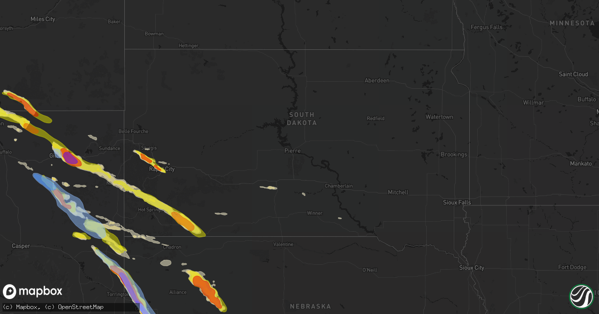
Hail Map in South Dakota on June 22, 2026
Get this storm
June 22 map
$229
one time, instant access
Download today. No call, no setup
Keep the $229
Bought the map and want the full workflow? Apply the entire $229 to a subscription within 7 days. None of it is wasted.
Every map, not just this one
This buys you this map. Subscription and you get every map we run, in the markets you choose from a few cities to whole states to nationwide. Plus real-time alerts the moment a storm fires.
Contact data
Name, contact info, occupancy, even credit band for addresses in the footprint. You go from where it hit to who to call.
Become the source they trust
Unlimited branding weather history reports on demand. You already have the documented answer ready for the property owner, and you are the one who showed up with it.
Property data and RoofTrace estimates
Pull up any address you have got, its value and the exact code rules for that jurisdiction, straight from One Click Code. Then RoofTrace estimates the squares, pitch, and roof value, priced the way you price.
Storm reports in South Dakota
South Dakota
| Date | Description |
|---|---|
| 06/22/20266:59 PM CDT | At nws rapid city office. |
| 06/22/20266:59 PM CDT | A local report indicates 1.75 inch wind near 4 WSW Dwtn Rapid City |
| 06/22/20266:58 PM CDT | Several social media reports and photos of hail as large as nickels and quarters across rapid city. Time estimated. |
| 06/22/20266:58 PM CDT | Between skyline dr and the mountain view cemetary area. Some stones still quarter size an hour after the storm. Time estimated. |
| 06/22/20266:56 PM CDT | Hail of at least quarter size covered the ground near dew drop laundromat. Photos and videos recieved via social media. Time estimated based on radar. |
| 06/22/20266:52 PM CDT | A local report indicates 1.75 inch wind near 2 WSW Dwtn Rapid City |
| 06/22/20266:18 PM CDT | Hail covered the ground to a depth of over 1 inch. Largest stones estimated at ping pong ball size. Time estimated based on radar. |
| 06/22/20265:47 PM CDT | Large amounts of hail completely covering the ground. Largest stones measured at quarter size. Very little wind. Time estimated based on radar. |
| 06/22/20265:46 PM CDT | Large amounts of hail covered the ground. Largest stones ping pong ball size. No wind. Time estimated based on radar. |
| 06/22/20265:40 PM CDT | Large quantities of hail covering the ground and roads to a depth of 2-3 inches. Most stones dime and nickel size. Initial stones when the hail started were quarter siz |
| 06/21/202611:00 PM CDT | A local report indicates 1.50 inch wind near Oglala |
| 06/21/202610:15 PM CDT | Mping report |
| 06/21/20267:15 PM CDT | Mping report. |
All States Impacted by Hail Map on June 22, 2026
Cities Impacted by Hail Map on June 22, 2026
- Bighorn, MT
- Lagrange, WY
- Riverside, NJ
- Beverly, NJ
- Willingboro, NJ
- Riverton, NJ
- Burlington, NJ
- Bordentown, NJ
- Mount Holly, NJ
- Moorestown, NJ
- Palm City, FL
- Port Saint Lucie, FL
- Columbus, NJ
- Chesterfield, NJ
- Wrightstown, NJ
- Florence, NJ
- Allentown, NJ
- Trenton, NJ
- Buffalo, WY
- Palmyra, NJ
- Philadelphia, PA
- Cream Ridge, NJ
- Myakka City, FL
- Parrish, FL
- Newton, GA
- Jobstown, NJ
- Albin, WY
- Clearmont, WY
- Stanley, VA
- Shenandoah, VA
- Moultrie, GA
- Birney, MT
- Fort Stockton, TX
- Shawnee, WY
- Douglas, WY
- Bushnell, NE
- Kimball, NE
- Bowling Green, FL
- Ona, FL
- Lost Springs, WY
- Pine Bluffs, WY
- Harrisburg, NE
- Lusk, WY
- Decker, MT
- Marathon, TX
- Ardmore, AL
- Toney, AL
- Elkmont, AL
- Athens, AL
- Troy, AL
- Harrison, NE
- Gillette, WY
- Otter, MT
- Banks, AL
- Harvest, AL
- Manville, WY
- Huntsville, AL
- Meridianville, AL
- Ochopee, FL
- Manassas, VA
- Clifton, VA
- Fountain, CO
- Colorado Springs, CO
- Hazel Green, AL
- Nashville, GA
- Arcadia, FL
- Labelle, FL
- New Market, AL
- Louisville, AL
- Midway, AL
- Clayton, AL
- Arvada, WY
- Huntland, TN
- Burke, VA
- Fairfax Station, VA
- Fairfax, VA
- Lehigh Acres, FL
- Immokalee, FL
- Venus, FL
- Elora, TN
- Flintville, TN
- Gurley, AL
- Princeton, AL
- Estillfork, AL
- Scottsboro, AL
- Recluse, WY
- Dix, NE
- Padroni, CO
- Peetz, CO
- Wright, WY
- Moore Haven, FL
- Jackson, GA
- Griffin, GA
- Fackler, AL
- Stevenson, AL
- Sherwood, TN
- South Pittsburg, TN
- Hollywood, AL
- Bridgeport, AL
- Flat Rock, AL
- Glenmoore, PA
- Downingtown, PA
- Chester Springs, PA
- Clewiston, FL
- Devils Tower, WY
- Kaycee, WY
- Jay Em, WY
- Ider, AL
- Pisgah, AL
- Trenton, GA
- Rising Fawn, GA
- Jasper, TN
- Bryant, AL
- Guild, TN
- Higdon, AL
- Torrington, WY
- Fort Myers, FL
- Moorcroft, WY
- Pennsauken, NJ
- Centreville, VA
- Honey Brook, PA
- Elverson, PA
- Union Grove, NC
- Hamptonville, NC
- Wildwood, GA
- Crane, TX
- Sundance, WY
- Bridgeport, NJ
- Lodge Grass, MT
- Levittown, PA
- Fairless Hills, PA
- Morrisville, PA
- Langhorne, PA
- Swedesboro, NJ
- Gibbstown, NJ
- Ridley Park, PA
- Crum Lynne, PA
- Harmony, NC
- New Raymer, CO
- Sterling, CO
- Iliff, CO
- Chattanooga, TN
- Ooltewah, TN
- Rossville, GA
- Ringgold, GA
- Flintstone, GA
- Whiteside, TN
- Lookout Mountain, TN
- Lookout Mountain, GA
- Fort Oglethorpe, GA
- Chickamauga, GA
- Whitwell, TN
- Bristol, PA
- Mickleton, NJ
- Mullica Hill, NJ
- Clarksboro, NJ
- Winston Salem, NC
- Danbury, NC
- Boone, CO
- Lead, SD
- Deadwood, SD
- Sturgis, SD
- Wyola, MT
- McDonald, TN
- Cohutta, GA
- Harrison, TN
- Apison, TN
- Cleveland, TN
- Queenstown, MD
- Lake Wales, FL
- Sheridan, WY
- Nemo, SD
- Crandall, GA
- Dalton, GA
- Old Fort, TN
- Piedmont, SD
- Shady Side, MD
- Stevensville, MD
- Churchton, MD
- Easton, MD
- Claiborne, MD
- Wye Mills, MD
- Grasonville, MD
- Fleming, CO
- McCamey, TX
- Haines City, FL
- Lance Creek, WY
- Merino, CO
- Pemberton, NJ
- Browns Mills, NJ
- Midkiff, TX
- Midland, TX
- Saint Michaels, MD
- Atwood, CO
- Queen Anne, MD
- Cordova, MD
- Mcdaniel, MD
- Odessa, TX
- Frostproof, FL
- Williamstown, NJ
- Hammonton, NJ
- Sicklerville, NJ
- Glenburn, ND
- Deering, ND
- Reliance, TN
- Benton, TN
- Ocoee, TN
- Charleston, TN
- Cisco, GA
- Copperhill, TN
- Fowler, CO
- Akron, CO
- Otis, CO
- Mitchell, NE
- Kenansville, FL
- River Ranch, FL
- Black Hawk, SD
- Hillsboro, MD
- Denton, MD
- Wittman, MD
- Morrill, NE
- Ridgely, MD
- Scottsbluff, NE
- Rapid City, SD
- Snyder, CO
- Gering, NE
- Minatare, NE
- Bayard, NE
- Mcgrew, NE
- Melbeta, NE
- Olney Springs, CO
- Manzanola, CO
- Rocky Ford, CO
- Ordway, CO
- Kim, CO
- Box Elder, SD
- La Junta, CO
- Dalton, NE
- Bridgeport, NE
- Potter, NE
- Yuma, CO
- Broadwater, NE
- Gurley, NE
- Cope, CO
- Joes, CO
- Anton, CO
- Trinidad, CO
- Rozet, WY
- Upton, WY
- Williamsburg, VA
- Las Animas, CO
- Hayes, VA
- Gloucester, VA
- Lodgepole, NE
- Sidney, NE
- Newcastle, WY
- Seibert, CO
- Vona, CO
- Flagler, CO
- Yorktown, VA
- Newport News, VA
- Chunky, MS
- Enterprise, MS
- Kirk, CO
- Stratton, CO
- Seaford, VA
- Osage, WY
- Homer, LA
- Bethune, CO
- Stonewall, MS
- Custer, SD
- Hill City, SD
- Quitman, MS
- Downsville, LA
- Strong, AR
- Spearsville, LA
- Edgemont, SD
- Bastrop, LA
- Farmerville, LA
- Calhoun, LA
- Pringle, SD
- Burlington, CO
- Bonita, LA
- West Monroe, LA
- Fairburn, SD
- Buffalo Gap, SD
- Hot Springs, SD
- Crossett, AR
- Cheyenne Wells, CO
- Buffalo, SD
- Oral, SD
- Pine Ridge, SD
- Oglala, SD
- Manderson, SD
- Wounded Knee, SD
- Pattonville, TX
- Blossom, TX
- Deport, TX
- Batesland, SD
- Gordon, NE
- Rushville, NE
- El Dorado, AR
- Annona, TX
- Avery, TX
- Mayersville, MS
- Whitney, NE
- Rolling Fork, MS
- Yazoo City, MS
- Holly Bluff, MS
- Ruston, LA
- Louise, MS
- Fouke, AR
- Mangum, OK
- Clarksville, TX
- Allen, SD
- Lewisville, AR
- Ravenna, TX
- Choudrant, LA
- Magnolia, AR
- Ivanhoe, TX
- Hendrix, OK
- Bonham, TX
- Martin, SD
- Emerson, AR
- Detroit, TX
- Bernice, LA
- Wellington, TX
- Maud, TX
- Duke, OK
- Dubach, LA
- Eros, LA
- Arcadia, LA
- Simsboro, LA
- Garland City, AR
- Bogata, TX
- Childress, TX
- Bradley, AR
- Hope, AR
- Eldorado, OK
- Chatham, LA
- Chadron, NE
- Butler, AL
- Sweet Water, AL
- Haynesville, LA
- Stamps, AR
- Arapahoe, CO
- Plain Dealing, LA
- Doddridge, AR
- Buckner, AR
- Rodessa, LA
- Waldo, AR
- Okaton, SD
- White River, SD
- Weskan, KS
- Murdo, SD
- Douglassville, TX
- Ida, LA
- Benton, LA
- Atlanta, TX
- Sharon Springs, KS
- Tribune, KS
- Plains, KS
- Meade, KS
- Ideal, SD
- Bivins, TX
- Crawford, NE
- Leoti, KS
- Marsland, NE
- Minden, LA
- Doyline, LA
- Princeton, LA
- Haughton, LA
- Winner, SD
- Fowler, KS
- Marietta, TX
- Marienthal, KS
- Hay Springs, NE
- Burke, SD
- Laverne, OK
- Elm Grove, LA
- Balko, OK
- Deerfield, KS
- Follett, TX
- Alliance, NE
- Lakin, KS
- Paris, TX
- Gate, OK
- Forgan, OK
- Holcomb, KS
- Ellsworth, NE
- Garden City, KS
- New Boston, TX
- Hooks, TX
- Texarkana, TX
- Shattuck, OK
- Benkelman, NE
- Bingham, NE
- Lakeside, NE
- Wauneta, NE
- De Kalb, TX
- Enders, NE
- Imperial, NE
- Max, NE
- Sublette, KS
- Stratton, NE
- Hugo, OK
- Ashdown, AR
- Boswell, OK
- Ashby, NE
- Oshkosh, NE
- Ulysses, KS
- Gage, OK
- Satanta, KS
- Idabel, OK
- Hyannis, NE
- Palisade, NE
- Arnett, OK
- Oakley, KS
- Simms, TX
- Elmore, AL
- Deatsville, AL
- Wetumpka, AL
- Millbrook, AL
- Montgomery, AL
- Hollytree, AL
- Hillsboro, AL
- Tanner, AL
- Madison, AL
- Decatur, AL
- Wakefield, VA
- Stony Creek, VA
- Rawlings, VA
- Crewe, VA
- Smithfield, VA
- Petersburg, VA
- Ivor, VA
- Carson, VA
- McKenney, VA
- Blackstone, VA
- Kenbridge, VA
- Dinwiddie, VA
- Windsor, VA
- Victoria, VA
- Warfield, VA
- Alberta, VA
- Dundas, VA
- Dewitt, VA
- Waverly, VA
- Disputanta, VA


