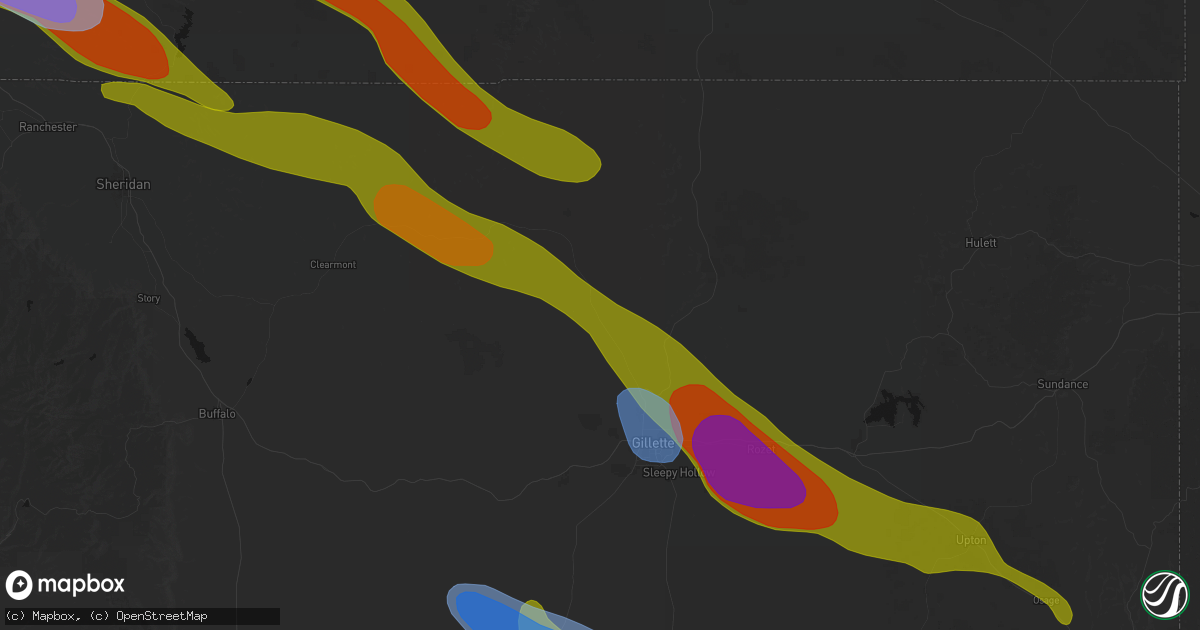
Hail Map in Gillette, WY on June 22, 2026
Get this storm
June 22 map
$229
one time, instant access
Download today. No call, no setup
Keep the $229
Bought the map and want the full workflow? Apply the entire $229 to a subscription within 7 days. None of it is wasted.
Every map, not just this one
This buys you this map. Subscription and you get every map we run, in the markets you choose from a few cities to whole states to nationwide. Plus real-time alerts the moment a storm fires.
Contact data
Name, contact info, occupancy, even credit band for addresses in the footprint. You go from where it hit to who to call.
Become the source they trust
Unlimited branding weather history reports on demand. You already have the documented answer ready for the property owner, and you are the one who showed up with it.
Property data and RoofTrace estimates
Pull up any address you have got, its value and the exact code rules for that jurisdiction, straight from One Click Code. Then RoofTrace estimates the squares, pitch, and roof value, priced the way you price.
Storm reports in Gillette, WY
Gillette, WY
| Date | Description |
|---|---|
| 06/22/20265:09 PM CDT | A local report indicates 67 MPH wind near 17 SSE Wright |
| 06/22/20264:23 PM CDT | Reported along highway 387. Emergency manager reports no damage in wright. |
| 06/22/20264:03 PM CDT | Photos taken along highway 50 relayed from the public by emergency management. Intermittant tornado touchdowns now span 235 pm to 303 pm on this storm. Most photos show |
| 06/22/20263:55 PM CDT | Powder river energy corporation reports structural damage and 13 power poles snapped off due to confirmed tornado. Time estimated. |
| 06/22/20263:48 PM CDT | Reports of several intermittant touchdowns from local emergency management and fire service officials with visual rotation continuing in between. Additional photo recie |
| 06/22/20263:44 PM CDT | A local report indicates 81 MPH wind near 10 WNW Savageton |
| 06/22/20263:35 PM CDT | Photo and video received. |
| 06/21/20268:03 PM CDT | No damage or significant wind reported with the hail. Time estimated based on radar. |
| 06/21/20268:01 PM CDT | A local report indicates 60 MPH wind near 6 N Dwtn Gillette |
| 06/21/20268:01 PM CDT | A local report indicates 1.00 inch wind near 6 N Dwtn Gillette |
| 06/21/20268:01 PM CDT | Measured on a personal weather station. |
| 06/21/20267:58 PM CDT | A local report indicates 66 MPH wind near 5 NNW Dwtn Gillette |
| 06/21/20267:49 PM CDT | At rawhide mine. Hail briefly covered the ground. Time estimated based on radar. |
All States Impacted by Hail Map on June 22, 2026
All Cities Impacted by Hail Map on June 22, 2026
- Bighorn, MT
- Lagrange, WY
- Riverside, NJ
- Beverly, NJ
- Willingboro, NJ
- Riverton, NJ
- Burlington, NJ
- Bordentown, NJ
- Mount Holly, NJ
- Moorestown, NJ
- Palm City, FL
- Port Saint Lucie, FL
- Columbus, NJ
- Chesterfield, NJ
- Wrightstown, NJ
- Florence, NJ
- Allentown, NJ
- Trenton, NJ
- Buffalo, WY
- Palmyra, NJ
- Philadelphia, PA
- Cream Ridge, NJ
- Myakka City, FL
- Parrish, FL
- Newton, GA
- Jobstown, NJ
- Albin, WY
- Clearmont, WY
- Stanley, VA
- Shenandoah, VA
- Moultrie, GA
- Birney, MT
- Fort Stockton, TX
- Shawnee, WY
- Douglas, WY
- Bushnell, NE
- Kimball, NE
- Bowling Green, FL
- Ona, FL
- Lost Springs, WY
- Pine Bluffs, WY
- Harrisburg, NE
- Lusk, WY
- Decker, MT
- Marathon, TX
- Ardmore, AL
- Toney, AL
- Elkmont, AL
- Athens, AL
- Troy, AL
- Harrison, NE
- Gillette, WY
- Otter, MT
- Banks, AL
- Harvest, AL
- Manville, WY
- Huntsville, AL
- Meridianville, AL
- Ochopee, FL
- Manassas, VA
- Clifton, VA
- Fountain, CO
- Colorado Springs, CO
- Hazel Green, AL
- Nashville, GA
- Arcadia, FL
- Labelle, FL
- New Market, AL
- Louisville, AL
- Midway, AL
- Clayton, AL
- Arvada, WY
- Huntland, TN
- Burke, VA
- Fairfax Station, VA
- Fairfax, VA
- Lehigh Acres, FL
- Immokalee, FL
- Venus, FL
- Elora, TN
- Flintville, TN
- Gurley, AL
- Princeton, AL
- Estillfork, AL
- Scottsboro, AL
- Recluse, WY
- Dix, NE
- Padroni, CO
- Peetz, CO
- Wright, WY
- Moore Haven, FL
- Jackson, GA
- Griffin, GA
- Fackler, AL
- Stevenson, AL
- Sherwood, TN
- South Pittsburg, TN
- Hollywood, AL
- Bridgeport, AL
- Flat Rock, AL
- Glenmoore, PA
- Downingtown, PA
- Chester Springs, PA
- Clewiston, FL
- Devils Tower, WY
- Kaycee, WY
- Jay Em, WY
- Ider, AL
- Pisgah, AL
- Trenton, GA
- Rising Fawn, GA
- Jasper, TN
- Bryant, AL
- Guild, TN
- Higdon, AL
- Torrington, WY
- Fort Myers, FL
- Moorcroft, WY
- Pennsauken, NJ
- Centreville, VA
- Honey Brook, PA
- Elverson, PA
- Union Grove, NC
- Hamptonville, NC
- Wildwood, GA
- Crane, TX
- Sundance, WY
- Bridgeport, NJ
- Lodge Grass, MT
- Levittown, PA
- Fairless Hills, PA
- Morrisville, PA
- Langhorne, PA
- Swedesboro, NJ
- Gibbstown, NJ
- Ridley Park, PA
- Crum Lynne, PA
- Harmony, NC
- New Raymer, CO
- Sterling, CO
- Iliff, CO
- Chattanooga, TN
- Ooltewah, TN
- Rossville, GA
- Ringgold, GA
- Flintstone, GA
- Whiteside, TN
- Lookout Mountain, TN
- Lookout Mountain, GA
- Fort Oglethorpe, GA
- Chickamauga, GA
- Whitwell, TN
- Bristol, PA
- Mickleton, NJ
- Mullica Hill, NJ
- Clarksboro, NJ
- Winston Salem, NC
- Danbury, NC
- Boone, CO
- Lead, SD
- Deadwood, SD
- Sturgis, SD
- Wyola, MT
- McDonald, TN
- Cohutta, GA
- Harrison, TN
- Apison, TN
- Cleveland, TN
- Queenstown, MD
- Lake Wales, FL
- Sheridan, WY
- Nemo, SD
- Crandall, GA
- Dalton, GA
- Old Fort, TN
- Piedmont, SD
- Shady Side, MD
- Stevensville, MD
- Churchton, MD
- Easton, MD
- Claiborne, MD
- Wye Mills, MD
- Grasonville, MD
- Fleming, CO
- McCamey, TX
- Haines City, FL
- Lance Creek, WY
- Merino, CO
- Pemberton, NJ
- Browns Mills, NJ
- Midkiff, TX
- Midland, TX
- Saint Michaels, MD
- Atwood, CO
- Queen Anne, MD
- Cordova, MD
- Mcdaniel, MD
- Odessa, TX
- Frostproof, FL
- Williamstown, NJ
- Hammonton, NJ
- Sicklerville, NJ
- Glenburn, ND
- Deering, ND
- Reliance, TN
- Benton, TN
- Ocoee, TN
- Charleston, TN
- Cisco, GA
- Copperhill, TN
- Fowler, CO
- Akron, CO
- Otis, CO
- Mitchell, NE
- Kenansville, FL
- River Ranch, FL
- Black Hawk, SD
- Hillsboro, MD
- Denton, MD
- Wittman, MD
- Morrill, NE
- Ridgely, MD
- Scottsbluff, NE
- Rapid City, SD
- Snyder, CO
- Gering, NE
- Minatare, NE
- Bayard, NE
- Mcgrew, NE
- Melbeta, NE
- Olney Springs, CO
- Manzanola, CO
- Rocky Ford, CO
- Ordway, CO
- Kim, CO
- Box Elder, SD
- La Junta, CO
- Dalton, NE
- Bridgeport, NE
- Potter, NE
- Yuma, CO
- Broadwater, NE
- Gurley, NE
- Cope, CO
- Joes, CO
- Anton, CO
- Trinidad, CO
- Rozet, WY
- Upton, WY
- Williamsburg, VA
- Las Animas, CO
- Hayes, VA
- Gloucester, VA
- Lodgepole, NE
- Sidney, NE
- Newcastle, WY
- Seibert, CO
- Vona, CO
- Flagler, CO
- Yorktown, VA
- Newport News, VA
- Chunky, MS
- Enterprise, MS
- Kirk, CO
- Stratton, CO
- Seaford, VA
- Osage, WY
- Homer, LA
- Bethune, CO
- Stonewall, MS
- Custer, SD
- Hill City, SD
- Quitman, MS
- Downsville, LA
- Strong, AR
- Spearsville, LA
- Edgemont, SD
- Bastrop, LA
- Farmerville, LA
- Calhoun, LA
- Pringle, SD
- Burlington, CO
- Bonita, LA
- West Monroe, LA
- Fairburn, SD
- Buffalo Gap, SD
- Hot Springs, SD
- Crossett, AR
- Cheyenne Wells, CO
- Buffalo, SD
- Oral, SD
- Pine Ridge, SD
- Oglala, SD
- Manderson, SD
- Wounded Knee, SD
- Pattonville, TX
- Blossom, TX
- Deport, TX
- Batesland, SD
- Gordon, NE
- Rushville, NE
- El Dorado, AR
- Annona, TX
- Avery, TX
- Mayersville, MS
- Whitney, NE
- Rolling Fork, MS
- Yazoo City, MS
- Holly Bluff, MS
- Ruston, LA
- Louise, MS
- Fouke, AR
- Mangum, OK
- Clarksville, TX
- Allen, SD
- Lewisville, AR
- Ravenna, TX
- Choudrant, LA
- Magnolia, AR
- Ivanhoe, TX
- Hendrix, OK
- Bonham, TX
- Martin, SD
- Emerson, AR
- Detroit, TX
- Bernice, LA
- Wellington, TX
- Maud, TX
- Duke, OK
- Dubach, LA
- Eros, LA
- Arcadia, LA
- Simsboro, LA
- Garland City, AR
- Bogata, TX
- Childress, TX
- Bradley, AR
- Hope, AR
- Eldorado, OK
- Chatham, LA
- Chadron, NE
- Butler, AL
- Sweet Water, AL
- Haynesville, LA
- Stamps, AR
- Arapahoe, CO
- Plain Dealing, LA
- Doddridge, AR
- Buckner, AR
- Rodessa, LA
- Waldo, AR
- Okaton, SD
- White River, SD
- Weskan, KS
- Murdo, SD
- Douglassville, TX
- Ida, LA
- Benton, LA
- Atlanta, TX
- Sharon Springs, KS
- Tribune, KS
- Plains, KS
- Meade, KS
- Ideal, SD
- Bivins, TX
- Crawford, NE
- Leoti, KS
- Marsland, NE
- Minden, LA
- Doyline, LA
- Princeton, LA
- Haughton, LA
- Winner, SD
- Fowler, KS
- Marietta, TX
- Marienthal, KS
- Hay Springs, NE
- Burke, SD
- Laverne, OK
- Elm Grove, LA
- Balko, OK
- Deerfield, KS
- Follett, TX
- Alliance, NE
- Lakin, KS
- Paris, TX
- Gate, OK
- Forgan, OK
- Holcomb, KS
- Ellsworth, NE
- Garden City, KS
- New Boston, TX
- Hooks, TX
- Texarkana, TX
- Shattuck, OK
- Benkelman, NE
- Bingham, NE
- Lakeside, NE
- Wauneta, NE
- De Kalb, TX
- Enders, NE
- Imperial, NE
- Max, NE
- Sublette, KS
- Stratton, NE
- Hugo, OK
- Ashdown, AR
- Boswell, OK
- Ashby, NE
- Oshkosh, NE
- Ulysses, KS
- Gage, OK
- Satanta, KS
- Idabel, OK
- Hyannis, NE
- Palisade, NE
- Arnett, OK
- Oakley, KS
- Simms, TX
- Elmore, AL
- Deatsville, AL
- Wetumpka, AL
- Millbrook, AL
- Montgomery, AL
- Hollytree, AL
- Hillsboro, AL
- Tanner, AL
- Madison, AL
- Decatur, AL
- Wakefield, VA
- Stony Creek, VA
- Rawlings, VA
- Crewe, VA
- Smithfield, VA
- Petersburg, VA
- Ivor, VA
- Carson, VA
- McKenney, VA
- Blackstone, VA
- Kenbridge, VA
- Dinwiddie, VA
- Windsor, VA
- Victoria, VA
- Warfield, VA
- Alberta, VA
- Dundas, VA
- Dewitt, VA
- Waverly, VA
- Disputanta, VA


