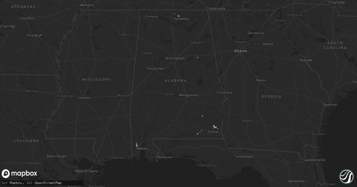
Hail Map in Alabama on June 22, 2025
Get this storm
June 22 map
$229
one time, instant access
Download today. No call, no setup
Keep the $229
Bought the map and want the full workflow? Apply the entire $229 to a subscription within 7 days. None of it is wasted.
Every map, not just this one
This buys you this map. Subscription and you get every map we run, in the markets you choose from a few cities to whole states to nationwide. Plus real-time alerts the moment a storm fires.
Contact data
Name, contact info, occupancy, even credit band for addresses in the footprint. You go from where it hit to who to call.
Become the source they trust
Unlimited branding weather history reports on demand. You already have the documented answer ready for the property owner, and you are the one who showed up with it.
Property data and RoofTrace estimates
Pull up any address you have got, its value and the exact code rules for that jurisdiction, straight from One Click Code. Then RoofTrace estimates the squares, pitch, and roof value, priced the way you price.
Storm reports in Alabama
Alabama
| Date | Description |
|---|---|
| 06/22/20255:54 PM CDT | A tree was knocked down and blocking the roadway at 1224 antioch road. Time estimated by radar. |
| 06/22/20255:36 PM CDT | Multiple trees down and power lines down in the 3200 area on county road 316. |
| 06/22/20255:13 PM CDT | Downed large tree limbs caused damage to a house on jeff road. Time estimated from radar. |
| 06/22/20254:58 PM CDT | Tree down blocking a couple lanes of traffic at moores mill road and highway 72. |
| 06/22/20254:56 PM CDT | Multiple trees down near county road 316 in trinity. Report and photos from social media. Time estimated from radar. |
| 06/22/20254:47 PM CDT | Large trees downed and uprooted near looney road in athens. Report and photos from social media. |
| 06/22/20254:43 PM CDT | A tree was knocked down blocking the roadway at the intersection of cr 358 and cr 547. Time estimated by radar. |
| 06/22/20253:47 PM CDT | Dale county dispatch reports a tree down on county road 61 near county road 512. |
| 06/22/20253:10 PM CDT | Geneva county dispatch reports a tree down on county road 65 near 5 points. |
| 06/22/20252:06 PM CDT | Tree down along cr 115. Time estimated by radar. |
All States Impacted by Hail Map on June 22, 2025
Cities Impacted by Hail Map on June 22, 2025
- Wilmot, SD
- Woodworth, ND
- Cooperstown, ND
- Bison, SD
- Finley, ND
- Sykeston, ND
- Beardsley, MN
- Peever, SD
- Carrington, ND
- Lodgepole, SD
- Graceville, MN
- Dumont, MN
- Browns Valley, MN
- Hannaford, ND
- Wheaton, MN
- Kensal, ND
- Nashua, MN
- Susquehanna, PA
- Thompson, PA
- Union Dale, PA
- Glenfield, ND
- Sharon, ND
- Lemmon, SD
- Mchenry, ND
- Elbow Lake, MN
- Grace City, ND
- Fergus Falls, MN
- Wendell, MN
- Campbell, MN
- Lakota, ND
- Aneta, ND
- Binford, ND
- Sutton, ND
- Vestal, NY
- Binghamton, NY
- Brackney, PA
- Brocket, ND
- Lawton, ND
- Northwood, ND
- Friendsville, PA
- Hettinger, ND
- Adams, ND
- Jessie, ND
- Selfridge, ND
- New Leipzig, ND
- Fairdale, ND
- Elgin, ND
- Montrose, PA
- Minto, ND
- Brundidge, AL
- Center, ND
- Towner, ND
- Washburn, ND
- Wilton, ND
- Karlsruhe, ND
- Wolford, ND
- Bisbee, ND
- Rugby, ND
- Corona, NM
- York, ND
- Columbia, AL
- Headland, AL
- Chancellor, AL
- Anamoose, ND
- Drake, ND
- Enterprise, AL
- Coffee Springs, AL
- Denhoff, ND
- Mcclusky, ND
- Ebro, FL
- Rocklake, ND
- Carriere, MS
- Newville, AL
- Calvin, ND
- Hannah, ND
- Munich, ND
- Midland City, AL
- College Station, TX
- Leeds, ND
- Maddock, ND
- Langdon, ND
- Santa Rosa, NM
- Dothan, AL
- Poplarville, MS
- Wewahitchka, FL
- Egeland, ND
- Wales, ND
- Oberon, ND
- Roswell, NM
- Cheyenne, WY
- Meriden, WY
- Purdum, NE
- Munford, AL
- Franklinton, LA
- Yoder, WY
- Hawk Springs, WY
- Lyman, NE
- Torrington, WY
- Stapleton, NE
- Dunning, NE
- Rotonda West, FL
- Bristol, FL
- Athens, AL
- Toney, AL
- Albin, WY
- Harvest, AL
- Arnold, NE
- Mitchell, NE
- Morrill, NE
- Harrisburg, NE
- Pine Bluffs, WY
- Cuervo, NM
- Newkirk, NM
- Devils Lake, ND
- Huntsville, AL
- Brewster, NE
- Gering, NE
- Logan, NM
- Tucumcari, NM
- Tallahassee, FL
- Taylor, NE
- Ainsworth, NE
- Conchas Dam, NM
- Bassett, NE
- Burwell, NE
- Bayard, NE
- Semmes, AL
- Mobile, AL
- Nara Visa, NM
- Bridgeport, NE
- Minatare, NE
- Mosquero, NM
- Eight Mile, AL
- Mcgrew, NE
- Angora, NE
- Broadwater, NE
- Atkinson, NE
- Stuart, NE
- San Jon, NM
- Chunchula, AL
- Channing, TX
- Amelia, NE
- Lisco, NE
- Adrian, TX
- Melrose, NM
- Clovis, NM
- Emmet, NE
- Chambers, NE
- Oneill, NE
- Inman, NE
- Springview, NE
- Grygla, MN
- Ellsworth, NE
- Oshkosh, NE
- Gatzke, MN
- Lakeside, NE
- Vega, TX
- Broadview, NM
- Bard, NM
- Hereford, TX
- Hartley, TX
- Dalhart, TX
- Winner, SD
- Bingham, NE
- Verdigre, NE
- Page, NE
- Anselmo, NE
- Colome, SD
- Dallas, SD
- Niobrara, NE
- Lynch, NE
- Ewing, NE
- Burke, SD
- Springfield, SD
- Dumas, TX
- Wildorado, TX
- Masterson, TX
- Amarillo, TX
- Stratford, TX
- Cactus, TX
- Sunray, TX
- Platte, SD
- Tabor, SD
- Kimball, SD
- Tatum, NM
- Valentine, NE
- Goodwell, OK
- Stinnett, TX
- Borger, TX
- Fritch, TX
- Panhandle, TX
- Spearman, TX
- Gruver, TX
- Morse, TX
- Canyon, TX
- Wagner, SD
- Scottsbluff, NE
- White Lake, SD
- Wood Lake, NE
- Avon, SD
- Bushnell, NE
- Loman, MN
- Tyndall, SD
- Scotland, SD
- Briggsdale, CO
- Grover, CO
- Johnstown, NE
- Lesterville, SD
- Roggen, CO
- Kersey, CO
- Kimball, NE
- Dexter, NM
- Orchard, CO
- Gregory, SD
- Long Pine, NE
- Brady, NE
- Weldona, CO
- Maxwell, NE
- Fort Morgan, CO
- Dix, NE
- Newport, NE
- Kabetogama, MN
- Clinton, MN
- Watertown, SD
- Ortonville, MN
- International Falls, MN
- Ranier, MN
- Goodwin, SD
- Jasper, MN
- Garretson, SD
- Labolt, SD
- Revillo, SD
- Milbank, SD
- Hardwick, MN
- Big Stone City, SD
- Bellingham, MN
- Odessa, MN
- Edgerton, MN
- Ord, NE
- Ericson, NE
- Elyria, NE
- Chandler, MN
- Montevideo, MN
- Benson, MN
- Cyrus, MN
- Starbuck, MN
- Watson, MN
- Clarissa, MN
- Bartlett, NE
- Staples, MN
- Browerville, MN
- Motley, MN
- Pillager, MN
- Milan, MN
- Nisswa, MN
- Brainerd, MN
- Pequot Lakes, MN
- North Loup, NE
- Pierz, MN
- Fort Ripley, MN
- Merrifield, MN
- Baxter, MN
- Crosby, MN
- Aitkin, MN
- Ironton, MN
- Deerwood, MN
- Crosslake, MN
- Onamia, MN
- Hillman, MN
- Palisade, MN
- Emily, MN
- Mcgregor, MN
- Isle, MN
- McGrath, MN
- Cromwell, MN
- Tamarack, MN
- Kettle River, MN
- Wright, MN
- Brookston, MN
- Floodwood, MN
- Sawyer, MN
- Jacobson, MN
- Meadowlands, MN
- Barnum, MN
- Cloquet, MN
- Alborn, MN
- Saginaw, MN
- Canyon, MN
- Carlton, MN
- Cotton, MN
- Forbes, MN
- Duluth, MN
- Two Harbors, MN
- Silver Bay, MN
- Donalsonville, GA
- Alvarado, MN
- Oslo, MN
- Argyle, MN
- Stephen, MN
- Grafton, ND
- Drayton, ND
- Warren, MN
- Donaldson, MN
- Kennedy, MN
- Karlstad, MN
- Halma, MN
- Grady, NM
- Boise City, OK
- Keyes, OK
- Texhoma, OK


