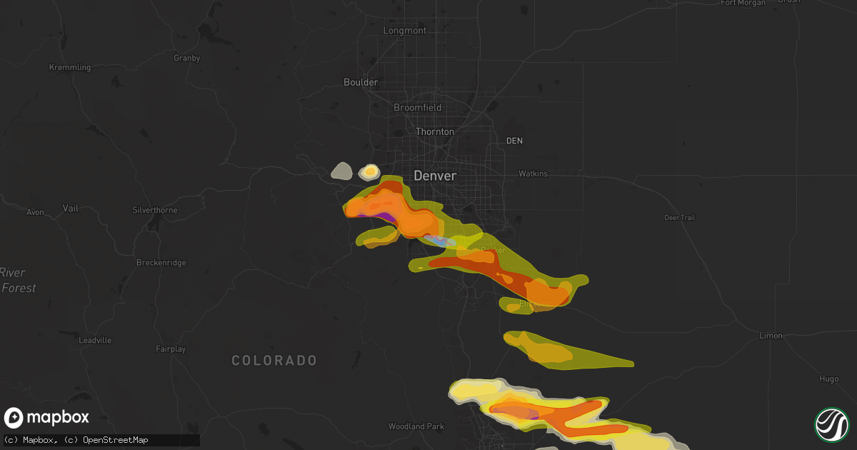
Hail Map in Littleton, CO on June 22, 2023
Get this storm
June 22 map
$229
one time, instant access
Download today. No call, no setup
Keep the $229
Bought the map and want the full workflow? Apply the entire $229 to a subscription within 7 days. None of it is wasted.
Every map, not just this one
This buys you this map. Subscription and you get every map we run, in the markets you choose from a few cities to whole states to nationwide. Plus real-time alerts the moment a storm fires.
Contact data
Name, contact info, occupancy, even credit band for addresses in the footprint. You go from where it hit to who to call.
Become the source they trust
Unlimited branding weather history reports on demand. You already have the documented answer ready for the property owner, and you are the one who showed up with it.
Property data and RoofTrace estimates
Pull up any address you have got, its value and the exact code rules for that jurisdiction, straight from One Click Code. Then RoofTrace estimates the squares, pitch, and roof value, priced the way you price.
Storm reports in Littleton, CO
Littleton, CO
| Date | Description |
|---|---|
| 06/22/20234:55 PM CDT | A local report indicates 1.00 inch wind near Highlands Ranch |
| 06/22/20234:52 PM CDT | Mesonet station cw2323 highlands ranch. |
| 06/22/20234:44 PM CDT | Several uprooted trees and broken tree limbs near the end of the tornadic circulation. |
| 06/22/20234:33 PM CDT | Report from mping: ping pong ball |
| 06/22/20234:33 PM CDT | Report from mping: quarter |
| 06/22/20234:30 PM CDT | A local report indicates 63 MPH wind near 2 S Littleton |
| 06/22/20234:25 PM CDT | Corrects previous tornado report from 2 wnw highlands ranch. Report via twitter video. |
| 06/22/20234:25 PM CDT | Report from mping: golf ball |
| 06/22/20234:23 PM CDT | A local report indicates 1.00 inch wind near 1 NNW Littleton |
| 06/22/20234:22 PM CDT | Report via twitter video. |
| 06/22/20234:20 PM CDT | Up to 2 inches in size. Damage to roof and window screens also reported. Time estimated by radar. |
| 06/22/20234:16 PM CDT | Report from mping: quarter |
| 06/22/20234:14 PM CDT | Report from mping: quarter |
| 06/22/20234:12 PM CDT | Report from mping: half dollar |
| 06/22/20234:12 PM CDT | A local report indicates 1.00 inch wind near 1 NNW Columbine |
| 06/22/20234:08 PM CDT | Report from mping: quarter |
| 06/22/20234:05 PM CDT | A local report indicates 1.75 inch wind near 3 NW Columbine |
| 06/22/20234:04 PM CDT | Report from mping: quarter |
All States Impacted by Hail Map on June 22, 2023
All Cities Impacted by Hail Map on June 22, 2023
- Holly, CO
- Granada, CO
- Satanta, KS
- Kismet, KS
- Liberal, KS
- Guymon, OK
- Hooker, OK
- Coyle, OK
- Hennessey, OK
- Sallisaw, OK
- Mooreland, OK
- Morris, OK
- Shattuck, OK
- Balko, OK
- Crescent, OK
- Perkins, OK
- Gans, OK
- Muskogee, OK
- Depew, OK
- Ames, OK
- Woodward, OK
- Webbers Falls, OK
- Bristow, OK
- Fargo, OK
- Fairview, OK
- Vian, OK
- Fort Supply, OK
- Chester, OK
- Beggs, OK
- Cushing, OK
- Oktaha, OK
- Warner, OK
- Arkoma, OK
- Stroud, OK
- Okeene, OK
- Isabella, OK
- Agra, OK
- Roland, OK
- Mulhall, OK
- Marshall, OK
- Tryon, OK
- Boynton, OK
- Okmulgee, OK
- Beaver, OK
- Muldrow, OK
- Fort Smith, AR
- Laverne, OK
- Goodwell, OK
- Kendall, KS
- Forgan, OK
- Lakin, KS
- Ulysses, KS
- Myakka City, FL
- Immokalee, FL
- Turpin, OK
- Micanopy, FL
- Manter, KS
- Hardesty, OK
- Plains, KS
- Sublette, KS
- Moscow, KS
- Arcadia, FL
- Ocala, FL
- Dunnellon, FL
- Wauchula, FL
- Zolfo Springs, FL
- Perryton, TX
- Booker, TX
- Higgins, TX
- Canadian, TX
- Evergreen, CO
- Kittredge, CO
- Golden, CO
- Weston, CO
- Trinidad, CO
- Trinchera, CO
- Morrison, CO
- Idledale, CO
- Indian Hills, CO
- Denver, CO
- Littleton, CO
- Raton, NM
- Englewood, CO
- Briscoe, TX
- Sweetwater, OK
- Reydon, OK
- Mclean, TX
- Clarendon, TX
- Cheyenne, OK
- Sedalia, CO
- Louviers, CO
- Lone Tree, CO
- Castle Rock, CO
- Parker, CO
- Sayre, OK
- Elk City, OK
- Aurora, CO
- Franktown, CO
- Quail, TX
- Wellington, TX
- Chugwater, WY
- Cheyenne, WY
- Elizabeth, CO
- Foss, OK
- Canute, OK
- Butler, OK
- Springer, NM
- Maxwell, NM
- Seymour, TX
- Holliday, TX
- Dill City, OK
- Cordell, OK
- Cimarron, NM
- Kiowa, CO
- Elbert, CO
- Bessie, OK
- Corn, OK
- Clinton, OK
- Hawk Springs, WY
- Childress, TX
- Colony, OK
- Weatherford, OK
- Hydro, OK
- Dodson, TX
- Peyton, CO
- Quanah, TX
- Central City, CO
- Black Hawk, CO
- Idaho Springs, CO
- Orange, TX
- Okeechobee, FL
- Vivian, SD
- Presho, SD
- Boulder, CO
- Gibson, LA
- Baudette, MN
- Sinclair, WY
- Custer, SD
- Hill City, SD
- Wamsutter, WY
- Colome, SD
- Ideal, SD
- Babson Park, FL
- Lake Wales, FL
- Hamill, SD
- Gregory, SD
- Venus, FL
- Chamberlain, SD
- Moultrie, GA
- Norman Park, GA
- Dallas, SD
- Lebanon, SD
- Seneca, SD
- Faulkton, SD
- Winner, SD
- Sulphur, LA
- Bell City, LA
- Iowa, LA
- Lake Charles, LA
- Westlake, LA
- Lorida, FL
- Daphne, AL
- Fort Pierce, FL
- Vero Beach, FL
- Bosler, WY
- Morgan City, LA
- Pierre Part, LA
- Gruver, TX
- Miami, TX
- Rawlins, WY
- Centennial, WY
- Laramie, WY
- Rock River, WY
- Groveland, FL
- Mount Dora, FL
- Leesburg, FL
- Center Hill, FL
- Webster, FL
- Astatula, FL
- Clermont, FL
- Howey In The Hills, FL
- Wheatland, WY
- Sunray, TX
- Onaka, SD
- Daytona Beach, FL
- Jay Em, WY
- Port Orange, FL
- Frostproof, FL
- Altoona, FL
- Summerfield, FL
- Pierson, FL
- Astor, FL
- Lakeland, FL
- Lake Placid, FL
- Moore Haven, FL
- Vidor, TX
- Berwick, LA
- Theriot, LA
- Patterson, LA
- Moss Point, MS
- Ochopee, FL
- Braithwaite, LA
- Port Sulphur, LA
- Milbank, SD
- Port Neches, TX
- Port Arthur, TX
- Grand Chenier, LA
- Long Pine, NE
- Tolstoy, SD
- Boncarbo, CO
- Hanna, WY
- Kennebec, SD
- Dade City, FL
- Buras, LA
- Raceland, LA
- Spearman, TX
- Georgetown, FL
- Crescent City, FL
- New Smyrna Beach, FL
- Calhan, CO
- Ramah, CO
- Trementina, NM
- Crowell, TX
- Lookeba, OK
- Binger, OK
- Hinton, OK
- Carnegie, OK
- Gracemont, OK
- Anadarko, OK
- Minco, OK
- Pocasset, OK
- Monument, CO
- Palmer Lake, CO
- Larkspur, CO
- Colorado Springs, CO
- Solano, NM
- Mosquero, NM
- Gladstone, NM
- Conchas Dam, NM
- Grenville, NM
- Roy, NM
- Tuttle, OK
- Clayton, NM
- Munday, TX
- Goree, TX
- Weinert, TX
- Matheson, CO
- Conifer, CO
- Logan, NM
- Yoder, CO
- Rush, CO
- Limon, CO
- Garita, NM
- Las Vegas, NM
- Burns, WY
- Pine Bluffs, WY
- Hugo, CO
- Strasburg, CO
- Yoder, WY
- Lizella, GA
- Byron, GA
- Macon, GA
- Bingham, NE
- Augusta, GA
- Lagrange, WY
- Simla, CO
- Harrison, NE
- Call, TX
- Kirbyville, TX
- Buna, TX
- Morrill, NE
- Mitchell, NE
- Lyman, NE
- Welsh, LA
- Dothan, AL
- Newton, AL
- Hammon, OK
- Rockham, SD
- Ashton, SD
- Northville, SD
- Miami, NM
- Des Moines, NM
- Graceville, FL
- Geneva, AL
- Saraland, AL
- Mobile, AL
- Chipley, FL
- Gueydan, LA
- Morse, LA
- Weirsdale, FL
- Douglas, WY
- Alliance, NE
- Wagon Mound, NM
- Memphis, TX
- Bennett, CO
- Manville, WY
- Jackson, SC
- Beech Island, SC
- Cokeville, WY
- Scottsbluff, NE
- Rock Springs, WY
- Sandersville, GA
- Lake Arthur, LA
- Tennille, GA
- Vancleave, MS
- Slocomb, AL
- Hartford, AL
- Bonifay, FL
- Bunnell, FL
- Roanoke, LA
- Shamrock, TX
- Liberty, TX
- Eight Mile, AL
- Perry, FL
- Mayo, FL
- Day, FL
- Oshkosh, NE
- Lakeside, NE
- Cuervo, NM
- Amistad, NM
- San Jon, NM
- Adrian, TX
- Bard, NM
- Grey Eagle, MN
- Swanville, MN
- Burtrum, MN
- Ocate, NM
- Lisco, NE
- Pukwana, SD
- Ellsworth, NE
- Bayard, NE
- Nunn, CO
- Pierce, CO
- Pine, CO
- Dalhart, TX
- Hartley, TX
- Mountain Park, OK
- Channing, TX
- Mills, NM
- Nara Visa, NM
- Ocean Springs, MS
- Dumas, TX
- Snyder, OK


