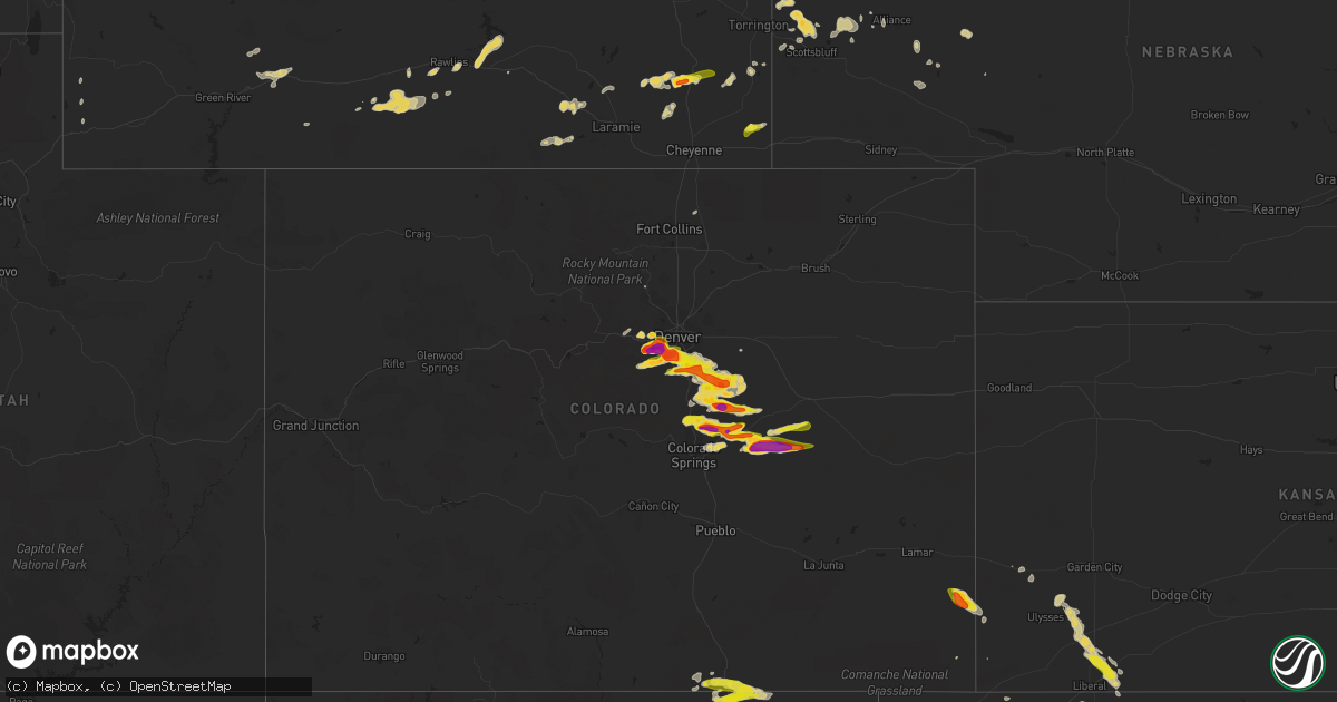
Hail Map on June 22, 2023
Get this storm
June 22 map
$229
one time, instant access
Download today. No call, no setup
Keep the $229
Bought the map and want the full workflow? Apply the entire $229 to a subscription within 7 days. None of it is wasted.
Every map, not just this one
This buys you this map. Subscription and you get every map we run, in the markets you choose from a few cities to whole states to nationwide. Plus real-time alerts the moment a storm fires.
Contact data
Name, contact info, occupancy, even credit band for addresses in the footprint. You go from where it hit to who to call.
Become the source they trust
Unlimited branding weather history reports on demand. You already have the documented answer ready for the property owner, and you are the one who showed up with it.
Property data and RoofTrace estimates
Pull up any address you have got, its value and the exact code rules for that jurisdiction, straight from One Click Code. Then RoofTrace estimates the squares, pitch, and roof value, priced the way you price.
States Impacted by Hail Map on June 22, 2023
Storm reports
Alabama
| Date | Description |
|---|---|
| 06/22/20235:06 PM CDT | Social media reports provided by bm of viewers receiving half-dollar size hail. Time using radar. |
| 06/22/20235:04 PM CDT | Nws employee reports a couple of trees down on us90. |
Texas
| Date | Description |
|---|---|
| 06/22/20236:43 PM CDT | From kolj. |
| 06/22/20233:51 PM CDT | County barn damaged... Roof damage to homes sustained... Unspecified window damage. Possible tornado to be determined. |
| 06/22/20233:45 PM CDT | Large branches broken off of mature... Healthy trees. Peach tree broken off at base and blown 50 yards away. Possible tornado to be determined. |
| 06/22/20233:23 PM CDT | A local report indicates 58 MPH wind near 10 E Miami |
| 06/22/202312:46 AM CDT | A local report indicates 66 MPH wind near 3 SW Dalhart |
| 06/21/20238:39 PM CDT | A local report indicates 1.00 inch wind near Munday |
| 06/21/20238:36 PM CDT | A local report indicates 2.75 inch wind near Rhineland |
| 06/21/20237:57 PM CDT | A local report indicates 1.00 inch wind near Crowell |
| 06/21/20237:57 PM CDT | A local report indicates 1.00 inch wind near Truscott |
| 06/21/20237:25 PM CDT | A local report indicates 2.50 inch wind near Crowell |
| 06/21/20237:00 PM CDT | Time estimated via radar. |
Georgia
| Date | Description |
|---|---|
| 06/22/20234:12 PM CDT | Tree down on florida short route road. |
| 06/22/20232:48 PM CDT | Tree down on highway 37 near rl sears road. Time estimated by radar. |
| 06/22/20232:48 PM CDT | Power lines down along baldy road. |
| 06/22/20232:48 PM CDT | Power lines down along baldy road. |
| 06/22/20232:47 PM CDT | Large oak tree down across highway 37 east of david newton road. Road blocked. Other trees down also noted down east of this location. |
| 06/21/202310:10 PM CDT | Large tree down on captain gay road. |
South Carolina
| Date | Description |
|---|---|
| 06/22/20233:03 AM CDT | Tree reported down in the 3500 block of forks road. The tree was blocking the roadway. Time estimated from radar. |
| 06/21/20238:55 PM CDT | Aiken dispatch reported a tree and power lines down at old dibble rd and banks mill rd. Time estimated. |
| 06/21/20238:23 PM CDT | Aiken dispatch reported trees down along pine log rd and williston rd in beech island. Time estimated. |
Oklahoma
| Date | Description |
|---|---|
| 06/22/20236:16 PM CDT | A local report indicates 74 MPH wind near 4 NNE Corn |
| 06/22/20235:12 PM CDT | 3-in tree limbs broken. |
| 06/22/20235:10 PM CDT | Large free-standing communications tower collapsed due to thunderstorm wind. Time estimated via radar. |
| 06/22/20234:40 PM CDT | A local report indicates 60 MPH wind near 5 ENE Dempsey |
| 06/22/20234:40 PM CDT | A local report indicates 60 MPH wind near 5 NE Dempsey |
North Carolina
| Date | Description |
|---|---|
| 06/22/20231:11 PM CDT | Edgecombe-martin electric coop reports nearly 80 customers without power around martin county. Time estimated based on radar data. |
| 06/22/202312:40 PM CDT | Trees down. Time estimated from radar. |
| 06/22/202312:40 PM CDT | Trees down... Transformer on fire... Stoplight not working. Time estimated from radar. |
| 06/22/202312:30 PM CDT | Delayed report. Pitt county 911 reported trees and power lines down in the calico area along highway 43 and highway 102. Time estimated based on radar. |
| 06/22/202312:17 PM CDT | Tree down... Blocking the road. Time estimated from radar. |
| 06/22/202312:02 PM CDT | Furniture fair on plaza blvd commercial building with hole in roof structural damage to a couple of buildings. Roughly maybe 1...000 or 1500 yards 2 ft trunks trees dow |
| 06/22/202312:00 PM CDT | Lenoir county em reported powerlines down and possible damage to the salvation army building in kinston... Nc. Time estimated from radar. |
| 06/22/202311:41 AM CDT | Delayed report. Onslow county reported trees and power lines down in the richlands area. Time estimated based on radar. |
| 06/22/202311:35 AM CDT | Roof shed blown off... Trees and powerline fallen. Time estimated from radar. |
| 06/22/202311:23 AM CDT | Delayed report. Duplin county 911 call center reported numerous trees and power lines down across the southern part of the county... Especially from chinquapin to beula |
New Mexico
| Date | Description |
|---|---|
| 06/22/20236:56 PM CDT | A local report indicates 1.75 inch wind near 8 W Abbott |
| 06/22/20236:28 PM CDT | A local report indicates 1.75 inch wind near 2 SE Springer |
| 06/22/20236:24 PM CDT | A local report indicates 1.50 inch wind near Springer |
| 06/22/20236:18 PM CDT | A local report indicates 2.00 inch wind near 1 N Springer |
| 06/22/20236:06 PM CDT | A local report indicates 1.00 inch wind near 2 NNE Sugarite Canyon S |
| 06/22/20235:31 PM CDT | A local report indicates 1.00 inch wind near 6 WNW Sugarite Canyon S |
| 06/22/20234:40 PM CDT | Mostly penny-sized hailstones... But a few quarter-sized were observed. |
| 06/21/202310:45 PM CDT | All hail... No rain. |
| 06/21/20239:35 PM CDT | Kent terry reported lots of lightning and gusty winds. Hail lasted from approximately 8:23 to 8:43 pm mdt. |
| 06/21/20239:05 PM CDT | A local report indicates 2.50 inch wind near 7 ENE Mosquero |
| 06/21/20238:45 PM CDT | A local report indicates 1.75 inch wind near 6 ENE Mosquero |
| 06/21/20237:58 PM CDT | Fell from 648 to 658 pm. Still hailing at the time of the report. |
| 06/21/20237:55 PM CDT | A local report indicates 1.50 inch wind near 2 NNE Yates |
| 06/21/20237:54 PM CDT | A local report indicates 1.25 inch wind near 3 SSE Roy |
| 06/21/20237:45 PM CDT | Mostly dime size hail... But some up to half dollars. |
| 06/21/20237:30 PM CDT | A local report indicates 1.00 inch wind near 8 ENE Solano |
| 06/21/20237:24 PM CDT | A local report indicates 2.00 inch wind near Abbott |
| 06/21/20237:20 PM CDT | Damage to flower gardens. |
| 06/21/20237:04 PM CDT | A local report indicates 1.25 inch wind near 1 W Abbott |
Colorado
| Date | Description |
|---|---|
| 06/22/20236:13 PM CDT | A local report indicates 2.00 inch wind near Elbert |
| 06/22/20236:08 PM CDT | Report from mping: half dollar |
| 06/22/20236:06 PM CDT | Report from mping: quarter |
| 06/22/20235:37 PM CDT | Report from mping: golf ball |
| 06/22/20235:35 PM CDT | A local report indicates 1.00 inch wind near 8 SE Castlewood Canyon |
| 06/22/20235:16 PM CDT | A local report indicates 1.00 inch wind near 2 E Franktown |
| 06/22/20235:15 PM CDT | Report from mping: half dollar |
| 06/22/20235:06 PM CDT | Report from mping: quarter |
| 06/22/20235:05 PM CDT | A local report indicates 1.00 inch wind near 4 ESE Foxfield |
| 06/22/20235:00 PM CDT | A local report indicates 1.00 inch wind near 1 WSW Castle Pines |
| 06/22/20234:57 PM CDT | Time estimated from radar. |
| 06/22/20234:56 PM CDT | Report from mping: quarter |
| 06/22/20234:55 PM CDT | A local report indicates 1.00 inch wind near Highlands Ranch |
| 06/22/20234:52 PM CDT | Mesonet station cw2323 highlands ranch. |
| 06/22/20234:44 PM CDT | Several uprooted trees and broken tree limbs near the end of the tornadic circulation. |
| 06/22/20234:38 PM CDT | Corrects previous hail report from 1 wsw castle pines. |
| 06/22/20234:33 PM CDT | Report from mping: quarter |
| 06/22/20234:33 PM CDT | Report from mping: ping pong ball |
| 06/22/20234:30 PM CDT | A local report indicates 63 MPH wind near 2 S Littleton |
| 06/22/20234:25 PM CDT | Report from mping: golf ball |
| 06/22/20234:25 PM CDT | A local report indicates 1.75 inch wind near 3 WSW Aurora |
| 06/22/20234:25 PM CDT | Corrects previous tornado report from 2 wnw highlands ranch. Report via twitter video. |
| 06/22/20234:23 PM CDT | A local report indicates 1.00 inch wind near 1 NNW Littleton |
| 06/22/20234:22 PM CDT | Report via twitter video. |
| 06/22/20234:20 PM CDT | Up to 2 inches in size. Damage to roof and window screens also reported. Time estimated by radar. |
| 06/22/20234:16 PM CDT | Report from mping: quarter |
| 06/22/20234:14 PM CDT | Report from mping: quarter |
| 06/22/20234:12 PM CDT | A local report indicates 1.00 inch wind near 1 NNW Columbine |
| 06/22/20234:12 PM CDT | Report from mping: half dollar |
| 06/22/20234:08 PM CDT | Report from mping: quarter |
| 06/22/20234:05 PM CDT | A local report indicates 1.75 inch wind near 3 NW Columbine |
| 06/22/20234:04 PM CDT | Report from mping: quarter |
| 06/22/20234:01 PM CDT | Report from mping: half dollar |
| 06/22/20233:59 PM CDT | Report from mping: quarter |
| 06/22/20233:51 PM CDT | A local report indicates 1.75 inch wind near 2 SE Morrison |
| 06/22/20233:50 PM CDT | Vehicle damage also reported. Time estimated by radar. |
| 06/22/20233:49 PM CDT | A local report indicates 2.00 inch wind near Morrison |
| 06/22/20233:44 PM CDT | Report from mping: quarter |
| 06/22/20233:39 PM CDT | Estimated hail size based on twitter image and spotter report. |
| 06/22/20233:38 PM CDT | A local report indicates 1.25 inch wind near Morrison |
| 06/22/20233:31 PM CDT | Corrects time of previous hail report from 2 nnw indian hills. Estimated hail size based on twitter image and spotter report. |
| 06/22/20233:25 PM CDT | Report from mping: quarter |
| 06/22/20233:19 PM CDT | A local report indicates 1.00 inch wind near 1 NNE Evergreen |
| 06/22/20233:17 PM CDT | A local report indicates 1.75 inch wind near 1 E Evergreen |
| 06/21/202310:30 PM CDT | A local report indicates 1.00 inch wind near 4 WNW Rush |
| 06/21/20239:58 PM CDT | A local report indicates 2.00 inch wind near 2 N Yoder |
| 06/21/20239:30 PM CDT | Accumulation of 1.5 inches of hail on the ground. |
| 06/21/20239:08 PM CDT | Brief cone tornado touched down for 2 minutes. |
| 06/21/20238:55 PM CDT | A local report indicates 1.00 inch wind near 3 N Falcon |
| 06/21/20238:43 PM CDT | Report from mping: quarter |
| 06/21/20238:14 PM CDT | A local report indicates 1.75 inch wind near 5 WNW Calhan |
| 06/21/20237:54 PM CDT | A local report indicates 1.00 inch wind near 6 ENE Black Forest |
| 06/21/20237:44 PM CDT | A local report indicates 1.50 inch wind near 2 ENE Black Forest |
| 06/21/20237:37 PM CDT | A local report indicates 1.50 inch wind near 4 WNW Black Forest |
| 06/21/20237:33 PM CDT | A local report indicates 2.00 inch wind near 3 NW Black Forest |
| 06/21/20237:30 PM CDT | A local report indicates 1.00 inch wind near 4 NNE Black Forest |
| 06/21/20237:28 PM CDT | A local report indicates 1.00 inch wind near 3 NW Black Forest |
| 06/21/20237:18 PM CDT | A local report indicates 1.00 inch wind near 5 E Monument |
| 06/21/20237:12 PM CDT | A local report indicates 1.25 inch wind near 1 S Monument |
| 06/21/20237:10 PM CDT | Report from mping: quarter |
Florida
| Date | Description |
|---|---|
| 06/22/20236:00 PM CDT | Trees down in the graceville area. |
| 06/22/20233:33 PM CDT | The asos at cape canaveral space force station |
| 06/22/20233:17 PM CDT | The asos at vero beach regional airport |
| 06/22/20232:06 PM CDT | The asos at orlando executive airport |
| 06/22/20232:00 PM CDT | Twitter report of trampolines flipped over by winds and damage to a shed roof in the s section of palm coast. Time estimated from radar. |
| 06/22/20231:55 PM CDT | Emergency manager relayed report of trees down on us 1 near cr 304. |
| 06/22/20231:14 AM CDT | 911 call center reported a power line was knocked down along beach road in perry. |
| 06/21/202310:26 PM CDT | Tree down on a power line in calhoun county. Location approximated. |
| 06/21/20239:27 PM CDT | Report of a power line down in south walton. Location approximated based on outage map. |
| 06/21/20238:58 PM CDT | Power line down along county road 12. |
| 06/21/20238:25 PM CDT | Trees down in the marianna area. |
| 06/21/20237:54 PM CDT | Mai asos measured 55 knot gust. |
| 06/21/20237:07 PM CDT | Trees down in the campbellton area. |
South Dakota
| Date | Description |
|---|---|
| 06/22/20235:36 PM CDT | Mesonet station 284 jct sd28/sd37 |
| 06/22/20235:31 PM CDT | Mesonet station 284 jct sd28/sd37 |
| 06/22/20235:31 PM CDT | Mesonet station 284 jc |
| 06/22/20235:29 PM CDT | Mesonet station 175 mellette |
Wyoming
| Date | Description |
|---|---|
| 06/22/20235:32 PM CDT | A local report indicates a tornado near 8 SSW Chugwater |
Louisiana
| Date | Description |
|---|---|
| 06/22/20235:06 PM CDT | Mostly nickel... Some larger. Whiteout conditions and winds estimated at least 50 mph. |
Cities Impacted by Hail Map on June 22, 2023
- Holly, CO
- Granada, CO
- Satanta, KS
- Kismet, KS
- Liberal, KS
- Guymon, OK
- Hooker, OK
- Coyle, OK
- Hennessey, OK
- Sallisaw, OK
- Mooreland, OK
- Morris, OK
- Shattuck, OK
- Balko, OK
- Crescent, OK
- Perkins, OK
- Gans, OK
- Muskogee, OK
- Depew, OK
- Ames, OK
- Woodward, OK
- Webbers Falls, OK
- Bristow, OK
- Fargo, OK
- Fairview, OK
- Vian, OK
- Fort Supply, OK
- Chester, OK
- Beggs, OK
- Cushing, OK
- Oktaha, OK
- Warner, OK
- Arkoma, OK
- Stroud, OK
- Okeene, OK
- Isabella, OK
- Agra, OK
- Roland, OK
- Mulhall, OK
- Marshall, OK
- Tryon, OK
- Boynton, OK
- Okmulgee, OK
- Beaver, OK
- Muldrow, OK
- Fort Smith, AR
- Laverne, OK
- Goodwell, OK
- Kendall, KS
- Forgan, OK
- Lakin, KS
- Ulysses, KS
- Myakka City, FL
- Immokalee, FL
- Turpin, OK
- Micanopy, FL
- Manter, KS
- Hardesty, OK
- Plains, KS
- Sublette, KS
- Moscow, KS
- Arcadia, FL
- Ocala, FL
- Dunnellon, FL
- Wauchula, FL
- Zolfo Springs, FL
- Perryton, TX
- Booker, TX
- Higgins, TX
- Canadian, TX
- Evergreen, CO
- Kittredge, CO
- Golden, CO
- Weston, CO
- Trinidad, CO
- Trinchera, CO
- Morrison, CO
- Idledale, CO
- Indian Hills, CO
- Denver, CO
- Littleton, CO
- Raton, NM
- Englewood, CO
- Briscoe, TX
- Sweetwater, OK
- Reydon, OK
- Mclean, TX
- Clarendon, TX
- Cheyenne, OK
- Sedalia, CO
- Louviers, CO
- Lone Tree, CO
- Castle Rock, CO
- Parker, CO
- Sayre, OK
- Elk City, OK
- Aurora, CO
- Franktown, CO
- Quail, TX
- Wellington, TX
- Chugwater, WY
- Cheyenne, WY
- Elizabeth, CO
- Foss, OK
- Canute, OK
- Butler, OK
- Springer, NM
- Maxwell, NM
- Seymour, TX
- Holliday, TX
- Dill City, OK
- Cordell, OK
- Cimarron, NM
- Kiowa, CO
- Elbert, CO
- Bessie, OK
- Corn, OK
- Clinton, OK
- Hawk Springs, WY
- Childress, TX
- Colony, OK
- Weatherford, OK
- Hydro, OK
- Dodson, TX
- Peyton, CO
- Quanah, TX
- Central City, CO
- Black Hawk, CO
- Idaho Springs, CO
- Orange, TX
- Okeechobee, FL
- Vivian, SD
- Presho, SD
- Boulder, CO
- Gibson, LA
- Baudette, MN
- Sinclair, WY
- Custer, SD
- Hill City, SD
- Wamsutter, WY
- Colome, SD
- Ideal, SD
- Babson Park, FL
- Lake Wales, FL
- Hamill, SD
- Gregory, SD
- Venus, FL
- Chamberlain, SD
- Moultrie, GA
- Norman Park, GA
- Dallas, SD
- Lebanon, SD
- Seneca, SD
- Faulkton, SD
- Winner, SD
- Sulphur, LA
- Bell City, LA
- Iowa, LA
- Lake Charles, LA
- Westlake, LA
- Lorida, FL
- Daphne, AL
- Fort Pierce, FL
- Vero Beach, FL
- Bosler, WY
- Morgan City, LA
- Pierre Part, LA
- Gruver, TX
- Miami, TX
- Rawlins, WY
- Centennial, WY
- Laramie, WY
- Rock River, WY
- Groveland, FL
- Mount Dora, FL
- Leesburg, FL
- Center Hill, FL
- Webster, FL
- Astatula, FL
- Clermont, FL
- Howey In The Hills, FL
- Wheatland, WY
- Sunray, TX
- Onaka, SD
- Daytona Beach, FL
- Jay Em, WY
- Port Orange, FL
- Frostproof, FL
- Altoona, FL
- Summerfield, FL
- Pierson, FL
- Astor, FL
- Lakeland, FL
- Lake Placid, FL
- Moore Haven, FL
- Vidor, TX
- Berwick, LA
- Theriot, LA
- Patterson, LA
- Moss Point, MS
- Ochopee, FL
- Braithwaite, LA
- Port Sulphur, LA
- Milbank, SD
- Port Neches, TX
- Port Arthur, TX
- Grand Chenier, LA
- Long Pine, NE
- Tolstoy, SD
- Boncarbo, CO
- Hanna, WY
- Kennebec, SD
- Dade City, FL
- Buras, LA
- Raceland, LA
- Spearman, TX
- Georgetown, FL
- Crescent City, FL
- New Smyrna Beach, FL
- Calhan, CO
- Ramah, CO
- Trementina, NM
- Crowell, TX
- Lookeba, OK
- Binger, OK
- Hinton, OK
- Carnegie, OK
- Gracemont, OK
- Anadarko, OK
- Minco, OK
- Pocasset, OK
- Monument, CO
- Palmer Lake, CO
- Larkspur, CO
- Colorado Springs, CO
- Solano, NM
- Mosquero, NM
- Gladstone, NM
- Conchas Dam, NM
- Grenville, NM
- Roy, NM
- Tuttle, OK
- Clayton, NM
- Munday, TX
- Goree, TX
- Weinert, TX
- Matheson, CO
- Conifer, CO
- Logan, NM
- Yoder, CO
- Rush, CO
- Limon, CO
- Garita, NM
- Las Vegas, NM
- Burns, WY
- Pine Bluffs, WY
- Hugo, CO
- Strasburg, CO
- Yoder, WY
- Lizella, GA
- Byron, GA
- Macon, GA
- Bingham, NE
- Augusta, GA
- Lagrange, WY
- Simla, CO
- Harrison, NE
- Call, TX
- Kirbyville, TX
- Buna, TX
- Morrill, NE
- Mitchell, NE
- Lyman, NE
- Welsh, LA
- Dothan, AL
- Newton, AL
- Hammon, OK
- Rockham, SD
- Ashton, SD
- Northville, SD
- Miami, NM
- Des Moines, NM
- Graceville, FL
- Geneva, AL
- Saraland, AL
- Mobile, AL
- Chipley, FL
- Gueydan, LA
- Morse, LA
- Weirsdale, FL
- Douglas, WY
- Alliance, NE
- Wagon Mound, NM
- Memphis, TX
- Bennett, CO
- Manville, WY
- Jackson, SC
- Beech Island, SC
- Cokeville, WY
- Scottsbluff, NE
- Rock Springs, WY
- Sandersville, GA
- Lake Arthur, LA
- Tennille, GA
- Vancleave, MS
- Slocomb, AL
- Hartford, AL
- Bonifay, FL
- Bunnell, FL
- Roanoke, LA
- Shamrock, TX
- Liberty, TX
- Eight Mile, AL
- Perry, FL
- Mayo, FL
- Day, FL
- Oshkosh, NE
- Lakeside, NE
- Cuervo, NM
- Amistad, NM
- San Jon, NM
- Adrian, TX
- Bard, NM
- Grey Eagle, MN
- Swanville, MN
- Burtrum, MN
- Ocate, NM
- Lisco, NE
- Pukwana, SD
- Ellsworth, NE
- Bayard, NE
- Nunn, CO
- Pierce, CO
- Pine, CO
- Dalhart, TX
- Hartley, TX
- Mountain Park, OK
- Channing, TX
- Mills, NM
- Nara Visa, NM
- Ocean Springs, MS
- Dumas, TX
- Snyder, OK