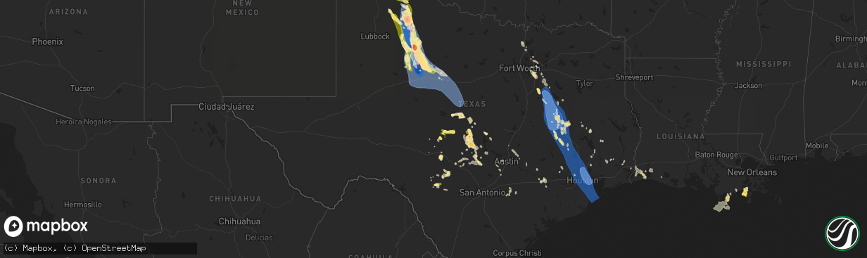
Hail Map in Texas on June 21, 2023
The weather event in Texas on June 21, 2023 includes Hail, Wind, and Tornado maps. 14 states and 520 cities were impacted and suffered possible damage. The total estimated number of properties impacted is 17,463.
Want more than just the map?
Turn this storm into a full workflow.
- Owner + property data so you know who to knock
- OnDemand branded weather history reports to win the "did we even have hail?" argument
- RoofTrace estimate so reps stop guessing numbers at the door
Bought this map? Upgrade within 7 days and we'll credit the $230. (10-15 min setup call)
Hail
Wind
Tornado
17,463
Estimated number of impacted properties by a 1.00" hail or larger12,571
Estimated number of impacted properties by a 1.75" hail or larger4,366
Estimated number of impacted properties by a 2.50" hail or largerStorm reports in Texas
Texas
| Date | Description |
|---|---|
| 06/21/20236:49 PM CDT | Small tree limbs broken. |
| 06/21/20236:48 PM CDT | Billboards blown down and multiple structures with roof damage in buffalo. |
| 06/21/20236:48 PM CDT | Roofs torn off hotels in buffalo. |
| 06/21/20236:45 PM CDT | Reports of quarter to larger than golf ball sized hail in stinnett. 6:45-6:50 pm time estimated based on radar. |
| 06/21/20236:40 PM CDT | Multiple collapsed electric transmission line metal truss towers near and between state highway 164 and ih-45. |
| 06/21/20236:39 PM CDT | 3 ft diameter tree blown on a house in buffalo. |
| 06/21/20236:26 PM CDT | Small tree branches broken. Hail of unknown size also occurred. |
| 06/21/20236:14 PM CDT | Roof blown off of preschool. |
| 06/21/20236:13 PM CDT | 2 inch hail in claude. Report received via social media. |
| 06/21/20236:10 PM CDT | Multiple repots of numerous large trees down on and near i-45 between buffalo and fairfield. |
| 06/21/20236:06 PM CDT | Baseball sized hail reported 4 miles south of claude along highway 207. |
| 06/21/20236:05 PM CDT | Multiple trees blown onto several houses in teague. |
| 06/21/20236:00 PM CDT | Report of wind damage 1 nw of fredericksburg via mping. |
| 06/21/20235:58 PM CDT | Sporadic ping pong sized hail 3 mi n of report location about 8 minutes ago. |
| 06/21/20235:58 PM CDT | Corrects previous report: sporadic ping pong sized hail 3 mi n of report location about 8 minutes ago. |
| 06/21/20235:55 PM CDT | Measured at gillespie county airport. |
| 06/21/20235:50 PM CDT | Broadcast media reports several instances of downed trees & tree branches between acorn and kay st in west fredericksburg. Time estimated from radar. |
| 06/21/20235:46 PM CDT | Half dollar sized hail reported by trained spotter. |
| 06/21/20235:35 PM CDT | Pea to golf ball sized hail falling at time of report. |
| 06/21/20235:32 PM CDT | Chaser report of ping pong ball sized hail north of conway... Tx. |
| 06/21/20235:30 PM CDT | A local report indicates 1.00 inch wind near Brady |
| 06/21/20235:23 PM CDT | A local report indicates 82 MPH wind near Corsicana |
| 06/21/20234:45 PM CDT | Report from mping: quarter |
| 06/21/20234:11 PM CDT | Kjct asos measured a 54 kt gust at 2111z. |
| 06/21/20233:55 PM CDT | Em reported multiple limbs... Trees... And utility poles down up to 4 miles south of downtown on hwy 83. Time estimated on radar. |
| 06/21/20233:53 PM CDT | Picture sent of dime to quarter sized hail in town. |
| 06/21/20233:48 PM CDT | Quarter sized hail. |
| 06/21/202312:52 AM CDT | Hamby fd responding to power poles and lines down near intersection of hwy 351 and fm 1082. |
| 06/21/202312:34 AM CDT | Continued severe winds lasting about 20 minutes from last lsr at dyess afb. |
| 06/21/202312:25 AM CDT | Kabi asos reported 64 kt gust. |
| 06/21/202312:22 AM CDT | Facebook picture of power pole down in south abilene. Time estimated based off radar. |
| 06/21/202312:19 AM CDT | Kdys asos at dyess afb reported gust to 58 mph. |
| 06/21/202312:18 AM CDT | Report from mping: 3-inch tree limbs broken; power poles broken. |
| 06/21/202312:15 AM CDT | Facebook picture of an outdoor storage shed heavily damaged. Time estimated based off radar. |
| 06/21/202312:15 AM CDT | Facebook picture of carport destroyed and blown into a neighbors yard. Time estimated based off radar. |
| 06/21/202312:15 AM CDT | Facebook picture of large portions of a tin roof peeled off in merkel. Time estimated based off radar. |
| 06/21/202312:10 AM CDT | Facebook post of a portion of a homes roof peeled away. Time estimated based off of radar. |
| 06/21/202312:10 AM CDT | Facebook photo of broken large tree limb that broke window of a home. Time estimated based off of radar. |
| 06/21/202312:05 AM CDT | Facebook post showing a photo of snapped power pole on county road 320 north of abilene. Time estimated based off radar. |
| 06/21/202312:00 AM CDT | Facebook post mentioning damage or destruction to the roof of a school in hawley. |
| 06/21/202312:00 AM CDT | Facebook picture of a portion of a tin roof peeled off. Time estimated based on radar. |
| 06/21/202312:00 AM CDT | Facebook post showing photo of metal stands blown onto a baseball field. Time estimated based off radar. |
| 06/20/202311:57 PM CDT | Tractor trailers blown over near mm 244 in sweetwater on i-20. |
| 06/20/202311:50 PM CDT | 64 kt gust at ksww asos. |
| 06/20/202311:48 PM CDT | Law enforcement reports power lines down on south side of roscoe. Intersection of fm 608 and i-20. |
| 06/20/202311:45 PM CDT | Part of roof blown off house and took down power lines in downtown sweetwater. |
| 06/20/202311:44 PM CDT | Metal roof blown off. Time estimated from radar. |
| 06/20/202311:44 PM CDT | Facebook post of uprooted medium sized tree in sweetwater. Time estimated based off radar. |
| 06/20/202311:43 PM CDT | 66 mph gust at ksww avenger field airport asos. |
| 06/20/202311:42 PM CDT | Report from mping: trees uprooted or snapped; roof blown off. |
| 06/20/202311:41 PM CDT | West texas mesonet 11 sw of sweetwater reported 74 mph gusts. |
| 06/20/202311:38 PM CDT | Report from mping: 1-inch tree limbs broken; shingles blown off. |
| 06/20/202311:06 PM CDT | Snyder 3e mesonet measured wind gust of 60 mph. |
| 06/20/202311:03 PM CDT | West texas mesonet 5w of rotan measured sustained winds at 83 and gusts to 95 mph. |
| 06/20/202311:02 PM CDT | Facebook pictures of roof and wall damage to an outbuilding... Severe roof damage to a house... Fence blown over... And tree limbs knocked down... Near fm 1812 in mccau |
| 06/20/202310:55 PM CDT | Facebook post showing photo of a destroyed garage and adjacent garage wall in roby. Time estimated based off of radar. |
| 06/20/202310:55 PM CDT | Facebook post of a portion of a roof peeled off. Time estimated based off radar. |
| 06/20/202310:42 PM CDT | Partial collapse of hardware store and exterior damage in the center of rotan. |
| 06/20/202310:10 PM CDT | A local report indicates 4.00 inch wind near Jayton |
| 06/20/202310:07 PM CDT | A local report indicates 109 MPH wind near 1 SSE Jayton |
| 06/20/202310:07 PM CDT | Sustained rfd winds as high as 86 mph. Severe winds from 957 pm to 1018 pm. Measured by the west texas mesonet. |
| 06/20/202310:00 PM CDT | Roofs removed from homes... Trees uprooted and downed power lines reported. Time estimated. |
| 06/20/202310:00 PM CDT | A local report indicates 100 MPH wind near 1 SSE Jayton |
| 06/20/20239:57 PM CDT | Tree down in street. |
| 06/20/20239:38 PM CDT | A local report indicates 59 MPH wind near 6 NW White River Lake |
| 06/20/20239:35 PM CDT | Several large pine trees downed onto homes and numerous fences downed. Measured wind gust of 82 mph. |
| 06/20/20239:34 PM CDT | Wind gust was measured at klvj. |
| 06/20/20239:34 PM CDT | A local report indicates 67 MPH wind near 10 WSW Guthrie |
| 06/20/20239:32 PM CDT | A local report indicates 84 MPH wind near 1 W Spur |
| 06/20/20239:20 PM CDT | A local report indicates a tornado near 8 E Dickens |
| 06/20/20239:15 PM CDT | Mesonet. |
| 06/20/20239:15 PM CDT | A local report indicates 65 MPH wind near 4 NNW Mcadoo |
| 06/20/20239:06 PM CDT | Kiah recorded a wind gust of 97 mph. |
| 06/20/20239:03 PM CDT | Numerous trees down... Some on homes... Woodcreek subdivision. |
| 06/20/20238:53 PM CDT | A local report indicates 80 MPH wind near 3 NNE Roaring Springs |
| 06/20/20238:53 PM CDT | West texas mesonet report. |
| 06/20/20238:53 PM CDT | West texas mesonet report |
| 06/20/20238:50 PM CDT | Large pine trees down. |
| 06/20/20238:42 PM CDT | Antennas brought down. |
| 06/20/20238:41 PM CDT | Wind gust was measured at kdwh. |
| 06/20/20238:41 PM CDT | Report of some aircraft flipped over at dw hooks airport. |
| 06/20/20238:35 PM CDT | Trees and fences down. |
| 06/20/20238:35 PM CDT | Multiple reports of trees down... Some on top of homes. A few large pine trees down. Pictures of a damage to a carport. |
| 06/20/20238:33 PM CDT | A local report indicates a tornado near 3 E Afton |
| 06/20/20238:33 PM CDT | Rain wrapped tornado reported by off-duty nws employee. |
| 06/20/20238:33 PM CDT | Rain wrapped tornado reported by off-duty nws employee |
| 06/20/20238:26 PM CDT | Trees down clark rd near jackson rd. |
| 06/20/20238:22 PM CDT | West texas mesonet report. |
| 06/20/20238:22 PM CDT | West texas mesonet report |
| 06/20/20238:15 PM CDT | Baseball size hail reported in matador. |
| 06/20/20238:15 PM CDT | Baseball size hail reported in matador |
| 06/20/20238:13 PM CDT | Multiple trees down near dobbin near intersection of sh 105 and fm 1486. |
| 06/20/20238:13 PM CDT | Matador cooperative observer report |
| 06/20/20238:11 PM CDT | *** 4 fatal... 9 inj *** significant damage on the west side of matador. Several buildings heavily damaged or destroyed. |
| 06/20/20238:11 PM CDT | Damage reported in the city of matador. |
| 06/20/20237:52 PM CDT | A local report indicates 64 MPH wind near 2 WSW Turkey |
| 06/20/20237:52 PM CDT | West texas mesonet report |
| 06/20/20237:45 PM CDT | 2 power poles broken and roof damage... With tin sheets blown off a part of a house. |
| 06/20/20237:44 PM CDT | Trees down... Morgan road. |
| 06/20/20237:40 PM CDT | Trees down... Birdwell rd. |
| 06/20/20237:38 PM CDT | Report of broken tree limbs 2 miles east of jonestown. Report relayed via mping. |
| 06/20/20237:38 PM CDT | Report from mping: quarter |
| 06/20/20237:33 PM CDT | Trees down... Hopewell road. |
| 06/20/20237:25 PM CDT | Wind gust was measured at k5pnv. |
| 06/20/20237:20 PM CDT | Broken window glass at tractor supply store. |
| 06/20/20237:20 PM CDT | Report of trees down in the madisonville area. |
| 06/20/20237:00 PM CDT | Parked 18-wheeler with box trailer flipped and utility pole bent. |
All States Impacted by Hail Map on June 21, 2023
Cities Impacted by Hail Map on June 21, 2023
- Casper, WY
- Natrona, WY
- Harrison, NE
- Torrington, WY
- Van Tassell, WY
- Glendo, WY
- Douglas, WY
- Garrett, WY
- Jay Em, WY
- Saint Francis, SD
- Rosebud, SD
- Kingman, KS
- Arlington, KS
- Murdock, KS
- Pretty Prairie, KS
- Cheney, KS
- Garden Plain, KS
- Goddard, KS
- Haven, KS
- Andale, KS
- Colwich, KS
- Mount Hope, KS
- Medford, OK
- Anthony, KS
- Holdrege, NE
- Loomis, NE
- Caldwell, KS
- Lamont, OK
- Deer Creek, OK
- Vernon, FL
- Tallahassee, FL
- Perry, OK
- Goltry, OK
- Tonkawa, OK
- Spivey, KS
- Attica, KS
- Billings, OK
- Helena, OK
- Partridge, KS
- Alva, OK
- Cherokee, OK
- Burlington, OK
- Wilmore, KS
- Lake Park, GA
- Meno, OK
- Waldron, KS
- Jet, OK
- Phillipsburg, KS
- Bluff City, KS
- Freeport, KS
- Orleans, NE
- Turon, KS
- Alma, NE
- Manchester, OK
- Hutchinson, KS
- Sidney, NE
- Iliff, CO
- Peetz, CO
- Padroni, CO
- Sterling, CO
- Akron, CO
- Otis, CO
- Junction, TX
- Rock River, WY
- Yuma, CO
- Colorado Springs, CO
- Monument, CO
- Usaf Academy, CO
- Menard, TX
- Pine Bluffs, WY
- Carpenter, WY
- Bushnell, NE
- Bosler, WY
- Grover, CO
- Eden, TX
- Brady, TX
- Gering, NE
- Melvin, TX
- Ennis, TX
- Italy, TX
- Barry, TX
- Blooming Grove, TX
- San Saba, TX
- Cherokee, TX
- Peyton, CO
- Brush, CO
- Wheatland, WY
- Calhan, CO
- Mitchell, NE
- Morrill, NE
- Panhandle, TX
- Groom, TX
- Gruver, TX
- Morse, TX
- Stinnett, TX
- Stoneham, CO
- Snyder, CO
- Claude, TX
- Clarendon, TX
- Golden Meadow, LA
- Galliano, LA
- Cut Off, LA
- Camp Wood, TX
- Uvalde, TX
- Leakey, TX
- Rio Frio, TX
- Yoder, CO
- Lusk, WY
- Hanna, WY
- Harrisburg, NE
- Kimball, NE
- Newcastle, WY
- Upton, WY
- The Colony, TX
- Carrollton, TX
- Dallas, TX
- Sanger, TX
- Merino, CO
- Estero, FL
- Labelle, FL
- Immokalee, FL
- Fort Myers, FL
- Moncks Corner, SC
- Bonneau, SC
- Fairhope, AL
- Gurley, NE
- Lancaster, TX
- Barksdale, TX
- Duncanville, TX
- Cedar Hill, TX
- Waxahachie, TX
- Red Oak, TX
- Desoto, TX
- Summerville, SC
- Moore Haven, FL
- Roosevelt, TX
- Sonora, TX
- Addison, TX
- Palmer, TX
- Ferris, TX
- Dalton, NE
- Grand Prairie, TX
- Dix, NE
- Montegut, LA
- Chauvin, LA
- Kit Carson, CO
- Valley View, TX
- Denton, TX
- Fort McKavett, TX
- Coppell, TX
- Osteen, FL
- Springfield, GA
- Rocksprings, TX
- Donie, TX
- Groesbeck, TX
- Teague, TX
- Fairfield, TX
- Mexia, TX
- Wortham, TX
- Thornton, TX
- Marquez, TX
- Jewett, TX
- Woodrow, CO
- Oakwood, TX
- Franklin, TX
- Buffalo, TX
- Kosse, TX
- Normangee, TX
- Centerville, TX
- Richland, TX
- Dawson, TX
- Purdon, TX
- Streetman, TX
- Corsicana, TX
- Rice, TX
- Powell, TX
- Cheyenne, WY
- Boulder, CO
- Borger, TX
- Golden, CO
- Concan, TX
- Eldorado Springs, CO
- Leona, TX
- Midway, TX
- Madisonville, TX
- North Zulch, TX
- Bryan, TX
- Hearne, TX
- Bedias, TX
- Goodwell, OK
- Guymon, OK
- Atwood, CO
- Flagler, CO
- Cope, CO
- Quitaque, TX
- Lakeview, TX
- Fort Morgan, CO
- Silverton, TX
- Matador, TX
- Turkey, TX
- Las Animas, CO
- Hudson, CO
- Keenesburg, CO
- Hugo, CO
- Karval, CO
- Iola, TX
- Anderson, TX
- Huntsville, TX
- Richards, TX
- Crockett, TX
- Denver, CO
- Skellytown, TX
- Brighton, CO
- Thornton, CO
- Henderson, CO
- Texhoma, OK
- Stratford, TX
- Broomfield, CO
- Lafayette, CO
- Idaho Springs, CO
- Evergreen, CO
- Yoder, WY
- Anton, CO
- Fort Collins, CO
- Roaring Springs, TX
- Afton, TX
- Texhoma, TX
- Magnolia, TX
- Plantersville, TX
- Waller, TX
- Navasota, TX
- Hockley, TX
- Montgomery, TX
- Spring, TX
- Cypress, TX
- Pinehurst, TX
- Willis, TX
- Conroe, TX
- Tomball, TX
- Fort Lupton, CO
- Longmont, CO
- Wellington, CO
- Walsh, CO
- Sugar City, CO
- Rush, CO
- Ordway, CO
- Ault, CO
- Flomot, TX
- Mcadoo, TX
- Dickens, TX
- Pierce, CO
- Deer Trail, CO
- Humble, TX
- Houston, TX
- Bellaire, TX
- Pasadena, TX
- Galena Park, TX
- Chugwater, WY
- New Waverly, TX
- Kingwood, TX
- Porter, TX
- La Porte, TX
- Crosby, TX
- Baytown, TX
- Channelview, TX
- Highlands, TX
- Deer Park, TX
- New Caney, TX
- Selfridge, ND
- Keldron, SD
- Morristown, SD
- Watauga, SD
- McIntosh, SD
- Byers, CO
- South Houston, TX
- Genoa, CO
- Rosharon, TX
- Missouri City, TX
- Friendswood, TX
- Manvel, TX
- Fresno, TX
- Alvin, TX
- Pearland, TX
- Webster, TX
- Stafford, TX
- Seabrook, TX
- Kemah, TX
- League City, TX
- McLaughlin, SD
- Floydada, TX
- Lockney, TX
- Dickinson, TX
- Hitchcock, TX
- La Marque, TX
- Bacliff, TX
- Texas City, TX
- Santa Fe, TX
- Galveston, TX
- Spur, TX
- Girard, TX
- Paducah, TX
- Snyder, TX
- Aurora, CO
- Jayton, TX
- Aspermont, TX
- Liverpool, TX
- Agate, CO
- Kittredge, CO
- Morrison, CO
- Indian Hills, CO
- Idledale, CO
- Rotan, TX
- Olney Springs, CO
- Crosbyton, TX
- Fountain, CO
- Kiowa, CO
- Elbert, CO
- Ramah, CO
- Commerce City, CO
- McCaulley, TX
- Roby, TX
- Hamlin, TX
- Hermleigh, TX
- Franktown, CO
- Larkspur, CO
- Simla, CO
- Elizabeth, CO
- Sylvester, TX
- Anson, TX
- Sweetwater, TX
- Pueblo, CO
- Merkel, TX
- Hawley, TX
- Trent, TX
- Lodgepole, NE
- Wasta, SD
- Houma, LA
- Dulac, LA
- Coupland, TX
- Taylor, TX
- Elgin, TX
- Hutto, TX
- Round Mountain, TX
- Buda, TX
- Kyle, TX
- Wimberley, TX
- Fredericksburg, TX
- Moorcroft, WY
- Sundance, WY
- Chappell, NE
- Hunt, TX
- Vanderpool, TX
- Rockwood, TX
- Batson, TX
- New Raymer, CO
- Lemmon, SD
- Cleveland, TX
- Brule, NE
- Johnson City, TX
- Blanco, TX
- Stonewall, TX
- Hye, TX
- Hempstead, TX
- Chatfield, TX
- Llano, TX
- Campo, CO
- Faith, SD
- Rochelle, TX
- Brookesmith, TX
- Santa Anna, TX
- Haswell, CO
- Kerrville, TX
- Valley Spring, TX
- Mobile, AL
- Lampasas, TX
- Nixon, TX
- Gonzales, TX
- Cost, TX
- Gillette, WY
- Doss, TX
- Richfield, KS
- Chadron, NE
- Groveton, TX
- Roscoe, TX
- Kingsland, TX
- Mason, TX
- Bellvue, CO
- Okeechobee, FL
- Lorida, FL
- Sebring, FL
- Loxahatchee, FL
- Hawk Springs, WY
- Theriot, LA
- Lindon, CO
- Platteville, CO
- Edgemont, SD
- Harper, TX
- Mountain Home, TX
- Georgetown, TX
- Willow City, TX
- Lead, SD
- Seibert, CO
- Pontotoc, TX
- Castell, TX
- Art, TX
- Marble Falls, TX
- Horseshoe Bay, TX
- Driftwood, TX
- Burnet, TX
- Lohn, TX
- Gouldbusk, TX
- Austin, TX
- Dupree, SD
- Evansville, WY
- Utopia, TX
- Sabinal, TX
- Maxwell, TX
- San Marcos, TX
- Mullin, TX
- Richland Springs, TX
- Goldthwaite, TX
- Prairie View, TX
- Vinton, LA
- Cameron, LA
- Hackberry, LA
- Huffman, TX
- Vero Beach, FL
- Tennessee Colony, TX
- Cherry Creek, SD
- Palmer Lake, CO
- Lake Charles, LA
- Livingston, TX
- Loraine, TX
- Abilene, TX
- Maryneal, TX
- Colorado City, TX
- Tye, TX
- Nolan, TX
- Blackwell, TX
- Tuscola, TX
- Ovalo, TX
- Wingate, TX
- Buffalo Gap, TX
- Dyess Afb, TX
- Albany, TX
- Clyde, TX
- Baird, TX
- Cross Plains, TX
- Dickinson, ND
- Belfield, ND
- South Heart, ND
- Taylor, ND
- Gladstone, ND
- Boone, CO
- Goldsboro, TX
- Lawn, TX
- Burkett, TX
- Coleman, TX
- Bangs, TX
- Brownwood, TX
- Richardton, ND
- Hebron, ND
- Beulah, ND
- Avondale, CO
- Fowler, CO
- Manzanola, CO
- Arlington, CO
- La Junta, CO
- Columbus, TX
- Parker, CO
- Castle Rock, CO
- Eaton, CO
- Conifer, CO
- Watkins, CO
- Vidor, TX
- Strasburg, CO
- Bennett, CO
- Bell City, LA
- Glidden, TX
- Weimar, TX
- Alleyton, TX
- Medora, ND
- Boise City, OK
- Laramie, WY
- Burlington, CO
- Stratton, CO
- Bethune, CO
- Saratoga, TX
- Kountze, TX
- Sour Lake, TX
- Hull, TX
- Smithville, TX
- Paige, TX
- Littleton, CO
- Drake, CO
- Black Hawk, CO
- Grand Chenier, LA
- Creole, LA
- Vona, CO
- Garwood, TX
- Round Top, TX
- Bridge City, TX
- Orange, TX
- Mead, CO
- Walker, SD
- Kanorado, KS
- Shepherd, TX
- Matheson, CO
- Limon, CO
- McClave, CO
- Hasty, CO
- Lamar, CO
- Ribera, NM
- Mott, ND
- Hettinger, ND
- Eads, CO
- Englewood, CO
- Wiley, CO
- Smiley, TX
- Granada, CO


