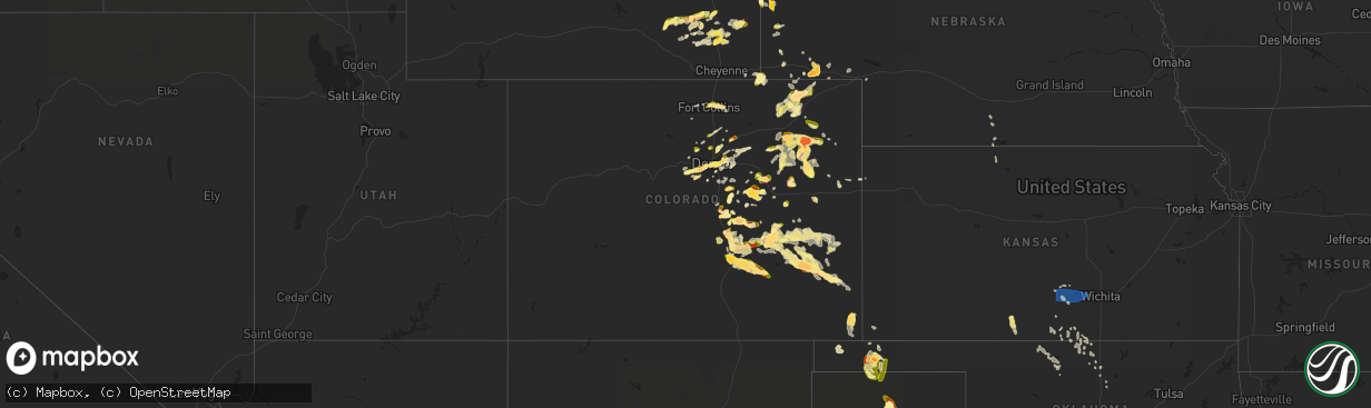
Hail Map in Colorado on June 21, 2023
The weather event in Colorado on June 21, 2023 includes Hail, Wind, and Tornado maps. 14 states and 520 cities were impacted and suffered possible damage. The total estimated number of properties impacted is 309,729.
Want more than just the map?
Turn this storm into a full workflow.
- Owner + property data so you know who to knock
- OnDemand branded weather history reports to win the "did we even have hail?" argument
- RoofTrace estimate so reps stop guessing numbers at the door
Bought this map? Upgrade within 7 days and we'll credit the $230. (10-15 min setup call)
Hail
Wind
Tornado
309,729
Estimated number of impacted properties by a 1.00" hail or larger86,684
Estimated number of impacted properties by a 1.75" hail or larger315
Estimated number of impacted properties by a 2.50" hail or largerStorm reports in Colorado
Colorado
| Date | Description |
|---|---|
| 06/21/20236:47 PM CDT | A local report indicates a tornado near 8 E Woodrow |
| 06/21/20236:45 PM CDT | A local report indicates 1.00 inch wind near 7 SE Flagler |
| 06/21/20236:38 PM CDT | A local report indicates a tornado near 4 E Willard |
| 06/21/20236:25 PM CDT | A local report indicates 1.60 inch wind near 5 SW Black Forest |
| 06/21/20236:00 PM CDT | A local report indicates 2.50 inch wind near 3 S Peyton |
| 06/21/20235:59 PM CDT | A local report indicates 1.00 inch wind near 4 SE Stoneham |
| 06/21/20235:51 PM CDT | A local report indicates 1.25 inch wind near 2 N Peterson AFB |
| 06/21/20235:50 PM CDT | A local report indicates 1.00 inch wind near 3 ENE Air Force Academy |
| 06/21/20235:33 PM CDT | A local report indicates 1.25 inch wind near 6 SSW Black Forest |
| 06/21/20235:30 PM CDT | A local report indicates 1.25 inch wind near 6 SSE Air Force Academy |
| 06/21/20235:28 PM CDT | Strongly rotating just a few miles to our north... Almost on the ground. |
| 06/21/20235:26 PM CDT | Spotter was 7 miles north of elba with a tornado 1-mile south of their area. |
| 06/21/20235:25 PM CDT | A local report indicates 1.25 inch wind near 5 SSE Air Force Academy |
| 06/21/20234:47 PM CDT | A local report indicates 1.50 inch wind near 5 SSW Black Forest |
| 06/21/20234:46 PM CDT | Thin rope. |
| 06/21/20234:46 PM CDT | Corrects previous tornado report from 2 e pawnee pass. Thin rope. |
| 06/21/20234:45 PM CDT | A local report indicates 1.75 inch wind near 10 N Colorado Springs |
| 06/21/20234:43 PM CDT | A local report indicates 1.00 inch wind near 5 SW Black Forest |
| 06/21/20234:42 PM CDT | A local report indicates 2.75 inch wind near 8 SSW Platner |
| 06/21/20234:39 PM CDT | A local report indicates 2.00 inch wind near 3 WSW Black Forest |
| 06/21/20234:33 PM CDT | A local report indicates 1.00 inch wind near 5 SW Black Forest |
| 06/21/20234:32 PM CDT | A local report indicates 1.25 inch wind near 1 E Logan Corners |
| 06/21/20234:32 PM CDT | A local report indicates 1.00 inch wind near 5 SSW Black Forest |
| 06/21/20234:25 PM CDT | A local report indicates 1.00 inch wind near 2 NNE Monument |
| 06/21/20234:20 PM CDT | Report from mping: quarter . |
| 06/21/20234:20 PM CDT | Report from mping: quarter |
| 06/21/20234:14 PM CDT | A local report indicates 1.50 inch wind near 4 W Black Forest |
| 06/21/20234:12 PM CDT | A local report indicates 1.00 inch wind near 3 E Air Force Academy |
| 06/21/20234:09 PM CDT | A local report indicates 1.00 inch wind near 3 ESE Air Force Academy |
| 06/21/20234:03 PM CDT | A local report indicates 2.00 inch wind near 1 S North Sterling Rese |
| 06/21/20234:03 PM CDT | Report from mping: quarter |
| 06/21/20234:02 PM CDT | A local report indicates 1.00 inch wind near 3 WSW Black Forest |
| 06/21/20234:00 PM CDT | Ping pong hail i-25 and briargate. |
| 06/21/20233:59 PM CDT | A local report indicates 2.00 inch wind near 1 S Sterling |
| 06/21/20233:49 PM CDT | Report from mping: quarter |
| 06/21/20233:08 PM CDT | A local report indicates 1.75 inch wind near 2 E North Sterling Rese |
| 06/21/20232:44 PM CDT | Corrects previous landspout report from 5 ssw padroni. Brief landspout lasted two minutes. |
| 06/21/20233:30 AM CDT | Personal weather station recorded a gust of 64 mph. |
| 06/21/20232:39 AM CDT | A local report indicates 1.00 inch wind near 2 WNW Blende |
| 06/21/20232:20 AM CDT | A local report indicates 1.00 inch wind near 9 SW Avondale |
| 06/21/20232:03 AM CDT | At nws pueblo. |
| 06/21/20231:53 AM CDT | A local report indicates 1.75 inch wind near 3 W Blende |
| 06/21/20231:00 AM CDT | Mostly smaller accumulating hail... But a few up to ping pong ball size estimated. |
| 06/21/202312:55 AM CDT | Falling along state highway 86. Location estimated. |
| 06/21/202312:38 AM CDT | Report via social media. Time estimated by radar. |
| 06/20/202311:35 PM CDT | Possible cone tornado. |
| 06/20/202311:02 PM CDT | Report from mping: ping pong ball |
| 06/20/202310:56 PM CDT | Report from mping: quarter |
| 06/20/202310:50 PM CDT | Delayed report. Time estimated by radar. |
| 06/20/202310:48 PM CDT | Dime to quarter size hail. |
| 06/20/202310:44 PM CDT | Report from mping: quarter |
| 06/20/202310:43 PM CDT | Second storm. Falling at the time of report again. |
| 06/20/202310:42 PM CDT | Report and photo via social media. Time and location estimated. |
| 06/20/202310:42 PM CDT | Report via social media. Time estimated by radar. |
| 06/20/202310:39 PM CDT | A local report indicates 1.25 inch wind near 3 NNE Fountain |
| 06/20/202310:38 PM CDT | Report via social media. Time estimated by radar. |
| 06/20/202310:35 PM CDT | Report via social media. |
| 06/20/202310:35 PM CDT | Report via social media. |
| 06/20/202310:34 PM CDT | Report via social media. Time estimated by radar. |
| 06/20/202310:26 PM CDT | *** 90 inj *** numerous reports of ping pong to 2 inch diameter hail in red rocks park. At least several dozen injuries treated on scene... With 7 hospitalizations. Inj |
| 06/20/202310:25 PM CDT | A local report indicates 1.00 inch wind near 3 NE Peterson AFB |
| 06/20/202310:16 PM CDT | Report via social media. Time estimated by radar. |
| 06/20/202310:08 PM CDT | Report via social media. Time estimated by radar. |
| 06/20/202310:07 PM CDT | Report from mping: half dollar |
| 06/20/202310:03 PM CDT | Via ham radio morning report. |
| 06/20/202310:02 PM CDT | Falling at time of report. |
| 06/20/202310:00 PM CDT | Reported by a cocorahs observer. Time estimated. |
| 06/20/20239:53 PM CDT | A local report indicates 1.25 inch wind near 4 E Denver |
| 06/20/20239:49 PM CDT | Report via social media. Time and location estimated. |
| 06/20/20239:48 PM CDT | Raws site tt561 dfpc portable 2. Time estimated by radar. |
| 06/20/20239:47 PM CDT | Report via social media. |
| 06/20/20239:46 PM CDT | Report and photo via social media. |
| 06/20/20239:42 PM CDT | Report and photo via social media. |
| 06/20/20239:37 PM CDT | Report via social media. Time estimated. |
| 06/20/20239:17 PM CDT | Report via spotternetwork. |
| 06/20/20239:14 PM CDT | Report via spotternetwork. |
| 06/20/20239:12 PM CDT | Asos station kako akron. Outflow winds from thunderstorms east of akron. |
| 06/20/20239:11 PM CDT | Report from mping: 3-inch tree limbs broken; power poles broken. |
| 06/20/20239:03 PM CDT | Report from mping: 1-inch tree limbs broken; shingles blown off. |
| 06/20/20239:02 PM CDT | Report from mping: 1-inch tree limbs broken; shingles blown off. |
| 06/20/20238:41 PM CDT | Report from mping: quarter |
| 06/20/20238:41 PM CDT | Report from mping: quarter |
| 06/20/20238:40 PM CDT | Time estimated from radar. |
| 06/20/20238:40 PM CDT | A local report indicates 2.00 inch wind near Walsh |
| 06/20/20238:36 PM CDT | Report via twitter. Time and location estimated. |
| 06/20/20238:35 PM CDT | A local report indicates 1.75 inch wind near Walsh |
| 06/20/20238:30 PM CDT | Report via cocorahs observer. Up to 1 inch hail... With average hail diameter near nickel size. Damaged shingles. |
| 06/20/20238:08 PM CDT | Largest hail stone found so far. Time estimated from radar. |
| 06/20/20238:04 PM CDT | A local report indicates 1.75 inch wind near 1 N Las Animas |
| 06/20/20237:57 PM CDT | A local report indicates 1.00 inch wind near 3 W Fort Lyon |
| 06/20/20237:54 PM CDT | Report from mping: quarter |
| 06/20/20237:53 PM CDT | A local report indicates 1.50 inch wind near 2 SW Fort Lyon |
| 06/20/20237:40 PM CDT | Estimated golf ball sized hail for approximately 30 minutes between 6:30 and 7:00 pm. |
| 06/20/20237:36 PM CDT | Report from mping: quarter |
| 06/20/20237:11 PM CDT | A local report indicates 1.00 inch wind near 3 SSE Boulder |
| 06/20/20237:08 PM CDT | A local report indicates 2.75 inch wind near 4 N Fort Lyon |
All States Impacted by Hail Map on June 21, 2023
Cities Impacted by Hail Map on June 21, 2023
- Casper, WY
- Natrona, WY
- Harrison, NE
- Torrington, WY
- Van Tassell, WY
- Glendo, WY
- Douglas, WY
- Garrett, WY
- Jay Em, WY
- Saint Francis, SD
- Rosebud, SD
- Kingman, KS
- Arlington, KS
- Murdock, KS
- Pretty Prairie, KS
- Cheney, KS
- Garden Plain, KS
- Goddard, KS
- Haven, KS
- Andale, KS
- Colwich, KS
- Mount Hope, KS
- Medford, OK
- Anthony, KS
- Holdrege, NE
- Loomis, NE
- Caldwell, KS
- Lamont, OK
- Deer Creek, OK
- Vernon, FL
- Tallahassee, FL
- Perry, OK
- Goltry, OK
- Tonkawa, OK
- Spivey, KS
- Attica, KS
- Billings, OK
- Helena, OK
- Partridge, KS
- Alva, OK
- Cherokee, OK
- Burlington, OK
- Wilmore, KS
- Lake Park, GA
- Meno, OK
- Waldron, KS
- Jet, OK
- Phillipsburg, KS
- Bluff City, KS
- Freeport, KS
- Orleans, NE
- Turon, KS
- Alma, NE
- Manchester, OK
- Hutchinson, KS
- Sidney, NE
- Iliff, CO
- Peetz, CO
- Padroni, CO
- Sterling, CO
- Akron, CO
- Otis, CO
- Junction, TX
- Rock River, WY
- Yuma, CO
- Colorado Springs, CO
- Monument, CO
- Usaf Academy, CO
- Menard, TX
- Pine Bluffs, WY
- Carpenter, WY
- Bushnell, NE
- Bosler, WY
- Grover, CO
- Eden, TX
- Brady, TX
- Gering, NE
- Melvin, TX
- Ennis, TX
- Italy, TX
- Barry, TX
- Blooming Grove, TX
- San Saba, TX
- Cherokee, TX
- Peyton, CO
- Brush, CO
- Wheatland, WY
- Calhan, CO
- Mitchell, NE
- Morrill, NE
- Panhandle, TX
- Groom, TX
- Gruver, TX
- Morse, TX
- Stinnett, TX
- Stoneham, CO
- Snyder, CO
- Claude, TX
- Clarendon, TX
- Golden Meadow, LA
- Galliano, LA
- Cut Off, LA
- Camp Wood, TX
- Uvalde, TX
- Leakey, TX
- Rio Frio, TX
- Yoder, CO
- Lusk, WY
- Hanna, WY
- Harrisburg, NE
- Kimball, NE
- Newcastle, WY
- Upton, WY
- The Colony, TX
- Carrollton, TX
- Dallas, TX
- Sanger, TX
- Merino, CO
- Estero, FL
- Labelle, FL
- Immokalee, FL
- Fort Myers, FL
- Moncks Corner, SC
- Bonneau, SC
- Fairhope, AL
- Gurley, NE
- Lancaster, TX
- Barksdale, TX
- Duncanville, TX
- Cedar Hill, TX
- Waxahachie, TX
- Red Oak, TX
- Desoto, TX
- Summerville, SC
- Moore Haven, FL
- Roosevelt, TX
- Sonora, TX
- Addison, TX
- Palmer, TX
- Ferris, TX
- Dalton, NE
- Grand Prairie, TX
- Dix, NE
- Montegut, LA
- Chauvin, LA
- Kit Carson, CO
- Valley View, TX
- Denton, TX
- Fort McKavett, TX
- Coppell, TX
- Osteen, FL
- Springfield, GA
- Rocksprings, TX
- Donie, TX
- Groesbeck, TX
- Teague, TX
- Fairfield, TX
- Mexia, TX
- Wortham, TX
- Thornton, TX
- Marquez, TX
- Jewett, TX
- Woodrow, CO
- Oakwood, TX
- Franklin, TX
- Buffalo, TX
- Kosse, TX
- Normangee, TX
- Centerville, TX
- Richland, TX
- Dawson, TX
- Purdon, TX
- Streetman, TX
- Corsicana, TX
- Rice, TX
- Powell, TX
- Cheyenne, WY
- Boulder, CO
- Borger, TX
- Golden, CO
- Concan, TX
- Eldorado Springs, CO
- Leona, TX
- Midway, TX
- Madisonville, TX
- North Zulch, TX
- Bryan, TX
- Hearne, TX
- Bedias, TX
- Goodwell, OK
- Guymon, OK
- Atwood, CO
- Flagler, CO
- Cope, CO
- Quitaque, TX
- Lakeview, TX
- Fort Morgan, CO
- Silverton, TX
- Matador, TX
- Turkey, TX
- Las Animas, CO
- Hudson, CO
- Keenesburg, CO
- Hugo, CO
- Karval, CO
- Iola, TX
- Anderson, TX
- Huntsville, TX
- Richards, TX
- Crockett, TX
- Denver, CO
- Skellytown, TX
- Brighton, CO
- Thornton, CO
- Henderson, CO
- Texhoma, OK
- Stratford, TX
- Broomfield, CO
- Lafayette, CO
- Idaho Springs, CO
- Evergreen, CO
- Yoder, WY
- Anton, CO
- Fort Collins, CO
- Roaring Springs, TX
- Afton, TX
- Texhoma, TX
- Magnolia, TX
- Plantersville, TX
- Waller, TX
- Navasota, TX
- Hockley, TX
- Montgomery, TX
- Spring, TX
- Cypress, TX
- Pinehurst, TX
- Willis, TX
- Conroe, TX
- Tomball, TX
- Fort Lupton, CO
- Longmont, CO
- Wellington, CO
- Walsh, CO
- Sugar City, CO
- Rush, CO
- Ordway, CO
- Ault, CO
- Flomot, TX
- Mcadoo, TX
- Dickens, TX
- Pierce, CO
- Deer Trail, CO
- Humble, TX
- Houston, TX
- Bellaire, TX
- Pasadena, TX
- Galena Park, TX
- Chugwater, WY
- New Waverly, TX
- Kingwood, TX
- Porter, TX
- La Porte, TX
- Crosby, TX
- Baytown, TX
- Channelview, TX
- Highlands, TX
- Deer Park, TX
- New Caney, TX
- Selfridge, ND
- Keldron, SD
- Morristown, SD
- Watauga, SD
- McIntosh, SD
- Byers, CO
- South Houston, TX
- Genoa, CO
- Rosharon, TX
- Missouri City, TX
- Friendswood, TX
- Manvel, TX
- Fresno, TX
- Alvin, TX
- Pearland, TX
- Webster, TX
- Stafford, TX
- Seabrook, TX
- Kemah, TX
- League City, TX
- McLaughlin, SD
- Floydada, TX
- Lockney, TX
- Dickinson, TX
- Hitchcock, TX
- La Marque, TX
- Bacliff, TX
- Texas City, TX
- Santa Fe, TX
- Galveston, TX
- Spur, TX
- Girard, TX
- Paducah, TX
- Snyder, TX
- Aurora, CO
- Jayton, TX
- Aspermont, TX
- Liverpool, TX
- Agate, CO
- Kittredge, CO
- Morrison, CO
- Indian Hills, CO
- Idledale, CO
- Rotan, TX
- Olney Springs, CO
- Crosbyton, TX
- Fountain, CO
- Kiowa, CO
- Elbert, CO
- Ramah, CO
- Commerce City, CO
- McCaulley, TX
- Roby, TX
- Hamlin, TX
- Hermleigh, TX
- Franktown, CO
- Larkspur, CO
- Simla, CO
- Elizabeth, CO
- Sylvester, TX
- Anson, TX
- Sweetwater, TX
- Pueblo, CO
- Merkel, TX
- Hawley, TX
- Trent, TX
- Lodgepole, NE
- Wasta, SD
- Houma, LA
- Dulac, LA
- Coupland, TX
- Taylor, TX
- Elgin, TX
- Hutto, TX
- Round Mountain, TX
- Buda, TX
- Kyle, TX
- Wimberley, TX
- Fredericksburg, TX
- Moorcroft, WY
- Sundance, WY
- Chappell, NE
- Hunt, TX
- Vanderpool, TX
- Rockwood, TX
- Batson, TX
- New Raymer, CO
- Lemmon, SD
- Cleveland, TX
- Brule, NE
- Johnson City, TX
- Blanco, TX
- Stonewall, TX
- Hye, TX
- Hempstead, TX
- Chatfield, TX
- Llano, TX
- Campo, CO
- Faith, SD
- Rochelle, TX
- Brookesmith, TX
- Santa Anna, TX
- Haswell, CO
- Kerrville, TX
- Valley Spring, TX
- Mobile, AL
- Lampasas, TX
- Nixon, TX
- Gonzales, TX
- Cost, TX
- Gillette, WY
- Doss, TX
- Richfield, KS
- Chadron, NE
- Groveton, TX
- Roscoe, TX
- Kingsland, TX
- Mason, TX
- Bellvue, CO
- Okeechobee, FL
- Lorida, FL
- Sebring, FL
- Loxahatchee, FL
- Hawk Springs, WY
- Theriot, LA
- Lindon, CO
- Platteville, CO
- Edgemont, SD
- Harper, TX
- Mountain Home, TX
- Georgetown, TX
- Willow City, TX
- Lead, SD
- Seibert, CO
- Pontotoc, TX
- Castell, TX
- Art, TX
- Marble Falls, TX
- Horseshoe Bay, TX
- Driftwood, TX
- Burnet, TX
- Lohn, TX
- Gouldbusk, TX
- Austin, TX
- Dupree, SD
- Evansville, WY
- Utopia, TX
- Sabinal, TX
- Maxwell, TX
- San Marcos, TX
- Mullin, TX
- Richland Springs, TX
- Goldthwaite, TX
- Prairie View, TX
- Vinton, LA
- Cameron, LA
- Hackberry, LA
- Huffman, TX
- Vero Beach, FL
- Tennessee Colony, TX
- Cherry Creek, SD
- Palmer Lake, CO
- Lake Charles, LA
- Livingston, TX
- Loraine, TX
- Abilene, TX
- Maryneal, TX
- Colorado City, TX
- Tye, TX
- Nolan, TX
- Blackwell, TX
- Tuscola, TX
- Ovalo, TX
- Wingate, TX
- Buffalo Gap, TX
- Dyess Afb, TX
- Albany, TX
- Clyde, TX
- Baird, TX
- Cross Plains, TX
- Dickinson, ND
- Belfield, ND
- South Heart, ND
- Taylor, ND
- Gladstone, ND
- Boone, CO
- Goldsboro, TX
- Lawn, TX
- Burkett, TX
- Coleman, TX
- Bangs, TX
- Brownwood, TX
- Richardton, ND
- Hebron, ND
- Beulah, ND
- Avondale, CO
- Fowler, CO
- Manzanola, CO
- Arlington, CO
- La Junta, CO
- Columbus, TX
- Parker, CO
- Castle Rock, CO
- Eaton, CO
- Conifer, CO
- Watkins, CO
- Vidor, TX
- Strasburg, CO
- Bennett, CO
- Bell City, LA
- Glidden, TX
- Weimar, TX
- Alleyton, TX
- Medora, ND
- Boise City, OK
- Laramie, WY
- Burlington, CO
- Stratton, CO
- Bethune, CO
- Saratoga, TX
- Kountze, TX
- Sour Lake, TX
- Hull, TX
- Smithville, TX
- Paige, TX
- Littleton, CO
- Drake, CO
- Black Hawk, CO
- Grand Chenier, LA
- Creole, LA
- Vona, CO
- Garwood, TX
- Round Top, TX
- Bridge City, TX
- Orange, TX
- Mead, CO
- Walker, SD
- Kanorado, KS
- Shepherd, TX
- Matheson, CO
- Limon, CO
- McClave, CO
- Hasty, CO
- Lamar, CO
- Ribera, NM
- Mott, ND
- Hettinger, ND
- Eads, CO
- Englewood, CO
- Wiley, CO
- Smiley, TX
- Granada, CO


