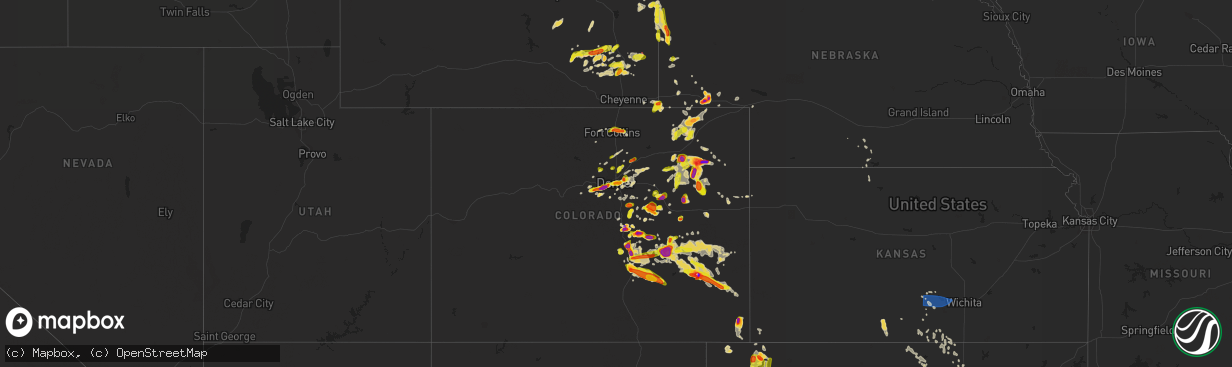
Hail Map on June 21, 2023
The weather event on June 21, 2023 includes Hail, Wind, and Tornado maps. 14 states and 520 cities were impacted and suffered possible damage. The total estimated number of properties impacted is 334,624.
Want more than just the map?
Turn this storm into a full workflow.
- Owner + property data so you know who to knock
- OnDemand branded weather history reports to win the "did we even have hail?" argument
- RoofTrace estimate so reps stop guessing numbers at the door
Bought this map? Upgrade within 7 days and we'll credit the $230. (10-15 min setup call)
Hail
Wind
Tornado
334,624
Estimated number of impacted properties by a 1.00" hail or larger101,781
Estimated number of impacted properties by a 1.75" hail or larger4,681
Estimated number of impacted properties by a 2.50" hail or largerStates Impacted by Hail Map on June 21, 2023
Storm reports
Texas
| Date | Description |
|---|---|
| 06/21/20236:49 PM CDT | Small tree limbs broken. |
| 06/21/20236:48 PM CDT | Billboards blown down and multiple structures with roof damage in buffalo. |
| 06/21/20236:48 PM CDT | Roofs torn off hotels in buffalo. |
| 06/21/20236:45 PM CDT | Reports of quarter to larger than golf ball sized hail in stinnett. 6:45-6:50 pm time estimated based on radar. |
| 06/21/20236:40 PM CDT | Multiple collapsed electric transmission line metal truss towers near and between state highway 164 and ih-45. |
| 06/21/20236:39 PM CDT | 3 ft diameter tree blown on a house in buffalo. |
| 06/21/20236:26 PM CDT | Small tree branches broken. Hail of unknown size also occurred. |
| 06/21/20236:14 PM CDT | Roof blown off of preschool. |
| 06/21/20236:13 PM CDT | 2 inch hail in claude. Report received via social media. |
| 06/21/20236:10 PM CDT | Multiple repots of numerous large trees down on and near i-45 between buffalo and fairfield. |
| 06/21/20236:06 PM CDT | Baseball sized hail reported 4 miles south of claude along highway 207. |
| 06/21/20236:05 PM CDT | Multiple trees blown onto several houses in teague. |
| 06/21/20236:00 PM CDT | Report of wind damage 1 nw of fredericksburg via mping. |
| 06/21/20235:58 PM CDT | Sporadic ping pong sized hail 3 mi n of report location about 8 minutes ago. |
| 06/21/20235:58 PM CDT | Corrects previous report: sporadic ping pong sized hail 3 mi n of report location about 8 minutes ago. |
| 06/21/20235:55 PM CDT | Measured at gillespie county airport. |
| 06/21/20235:50 PM CDT | Broadcast media reports several instances of downed trees & tree branches between acorn and kay st in west fredericksburg. Time estimated from radar. |
| 06/21/20235:46 PM CDT | Half dollar sized hail reported by trained spotter. |
| 06/21/20235:35 PM CDT | Pea to golf ball sized hail falling at time of report. |
| 06/21/20235:32 PM CDT | Chaser report of ping pong ball sized hail north of conway... Tx. |
| 06/21/20235:30 PM CDT | A local report indicates 1.00 inch wind near Brady |
| 06/21/20235:23 PM CDT | A local report indicates 82 MPH wind near Corsicana |
| 06/21/20234:45 PM CDT | Report from mping: quarter |
| 06/21/20234:11 PM CDT | Kjct asos measured a 54 kt gust at 2111z. |
| 06/21/20233:55 PM CDT | Em reported multiple limbs... Trees... And utility poles down up to 4 miles south of downtown on hwy 83. Time estimated on radar. |
| 06/21/20233:53 PM CDT | Picture sent of dime to quarter sized hail in town. |
| 06/21/20233:48 PM CDT | Quarter sized hail. |
| 06/21/202312:52 AM CDT | Hamby fd responding to power poles and lines down near intersection of hwy 351 and fm 1082. |
| 06/21/202312:34 AM CDT | Continued severe winds lasting about 20 minutes from last lsr at dyess afb. |
| 06/21/202312:25 AM CDT | Kabi asos reported 64 kt gust. |
| 06/21/202312:22 AM CDT | Facebook picture of power pole down in south abilene. Time estimated based off radar. |
| 06/21/202312:19 AM CDT | Kdys asos at dyess afb reported gust to 58 mph. |
| 06/21/202312:18 AM CDT | Report from mping: 3-inch tree limbs broken; power poles broken. |
| 06/21/202312:15 AM CDT | Facebook picture of an outdoor storage shed heavily damaged. Time estimated based off radar. |
| 06/21/202312:15 AM CDT | Facebook picture of large portions of a tin roof peeled off in merkel. Time estimated based off radar. |
| 06/21/202312:15 AM CDT | Facebook picture of carport destroyed and blown into a neighbors yard. Time estimated based off radar. |
| 06/21/202312:10 AM CDT | Facebook photo of broken large tree limb that broke window of a home. Time estimated based off of radar. |
| 06/21/202312:10 AM CDT | Facebook post of a portion of a homes roof peeled away. Time estimated based off of radar. |
| 06/21/202312:05 AM CDT | Facebook post showing a photo of snapped power pole on county road 320 north of abilene. Time estimated based off radar. |
| 06/21/202312:00 AM CDT | Facebook picture of a portion of a tin roof peeled off. Time estimated based on radar. |
| 06/21/202312:00 AM CDT | Facebook post showing photo of metal stands blown onto a baseball field. Time estimated based off radar. |
| 06/21/202312:00 AM CDT | Facebook post mentioning damage or destruction to the roof of a school in hawley. |
| 06/20/202311:57 PM CDT | Tractor trailers blown over near mm 244 in sweetwater on i-20. |
| 06/20/202311:50 PM CDT | 64 kt gust at ksww asos. |
| 06/20/202311:48 PM CDT | Law enforcement reports power lines down on south side of roscoe. Intersection of fm 608 and i-20. |
| 06/20/202311:45 PM CDT | Part of roof blown off house and took down power lines in downtown sweetwater. |
| 06/20/202311:44 PM CDT | Metal roof blown off. Time estimated from radar. |
| 06/20/202311:44 PM CDT | Facebook post of uprooted medium sized tree in sweetwater. Time estimated based off radar. |
| 06/20/202311:43 PM CDT | 66 mph gust at ksww avenger field airport asos. |
| 06/20/202311:42 PM CDT | Report from mping: trees uprooted or snapped; roof blown off. |
| 06/20/202311:41 PM CDT | West texas mesonet 11 sw of sweetwater reported 74 mph gusts. |
| 06/20/202311:38 PM CDT | Report from mping: 1-inch tree limbs broken; shingles blown off. |
| 06/20/202311:06 PM CDT | Snyder 3e mesonet measured wind gust of 60 mph. |
| 06/20/202311:03 PM CDT | West texas mesonet 5w of rotan measured sustained winds at 83 and gusts to 95 mph. |
| 06/20/202311:02 PM CDT | Facebook pictures of roof and wall damage to an outbuilding... Severe roof damage to a house... Fence blown over... And tree limbs knocked down... Near fm 1812 in mccau |
| 06/20/202310:55 PM CDT | Facebook post of a portion of a roof peeled off. Time estimated based off radar. |
| 06/20/202310:55 PM CDT | Facebook post showing photo of a destroyed garage and adjacent garage wall in roby. Time estimated based off of radar. |
| 06/20/202310:42 PM CDT | Partial collapse of hardware store and exterior damage in the center of rotan. |
| 06/20/202310:10 PM CDT | A local report indicates 4.00 inch wind near Jayton |
| 06/20/202310:07 PM CDT | Sustained rfd winds as high as 86 mph. Severe winds from 957 pm to 1018 pm. Measured by the west texas mesonet. |
| 06/20/202310:07 PM CDT | A local report indicates 109 MPH wind near 1 SSE Jayton |
| 06/20/202310:00 PM CDT | Roofs removed from homes... Trees uprooted and downed power lines reported. Time estimated. |
| 06/20/202310:00 PM CDT | A local report indicates 100 MPH wind near 1 SSE Jayton |
| 06/20/20239:57 PM CDT | Tree down in street. |
| 06/20/20239:38 PM CDT | A local report indicates 59 MPH wind near 6 NW White River Lake |
| 06/20/20239:35 PM CDT | Several large pine trees downed onto homes and numerous fences downed. Measured wind gust of 82 mph. |
| 06/20/20239:34 PM CDT | Wind gust was measured at klvj. |
| 06/20/20239:34 PM CDT | A local report indicates 67 MPH wind near 10 WSW Guthrie |
| 06/20/20239:32 PM CDT | A local report indicates 84 MPH wind near 1 W Spur |
| 06/20/20239:20 PM CDT | A local report indicates a tornado near 8 E Dickens |
| 06/20/20239:15 PM CDT | Mesonet. |
| 06/20/20239:15 PM CDT | A local report indicates 65 MPH wind near 4 NNW Mcadoo |
| 06/20/20239:06 PM CDT | Kiah recorded a wind gust of 97 mph. |
| 06/20/20239:03 PM CDT | Numerous trees down... Some on homes... Woodcreek subdivision. |
| 06/20/20238:53 PM CDT | West texas mesonet report. |
| 06/20/20238:53 PM CDT | A local report indicates 80 MPH wind near 3 NNE Roaring Springs |
| 06/20/20238:53 PM CDT | West texas mesonet report |
| 06/20/20238:50 PM CDT | Large pine trees down. |
| 06/20/20238:42 PM CDT | Antennas brought down. |
| 06/20/20238:41 PM CDT | Wind gust was measured at kdwh. |
| 06/20/20238:41 PM CDT | Report of some aircraft flipped over at dw hooks airport. |
| 06/20/20238:35 PM CDT | Multiple reports of trees down... Some on top of homes. A few large pine trees down. Pictures of a damage to a carport. |
| 06/20/20238:35 PM CDT | Trees and fences down. |
| 06/20/20238:33 PM CDT | Rain wrapped tornado reported by off-duty nws employee |
| 06/20/20238:33 PM CDT | Rain wrapped tornado reported by off-duty nws employee. |
| 06/20/20238:33 PM CDT | A local report indicates a tornado near 3 E Afton |
| 06/20/20238:26 PM CDT | Trees down clark rd near jackson rd. |
| 06/20/20238:22 PM CDT | West texas mesonet report |
| 06/20/20238:22 PM CDT | West texas mesonet report. |
| 06/20/20238:15 PM CDT | Baseball size hail reported in matador. |
| 06/20/20238:15 PM CDT | Baseball size hail reported in matador |
| 06/20/20238:13 PM CDT | Multiple trees down near dobbin near intersection of sh 105 and fm 1486. |
| 06/20/20238:13 PM CDT | Matador cooperative observer report |
| 06/20/20238:11 PM CDT | *** 4 fatal... 9 inj *** significant damage on the west side of matador. Several buildings heavily damaged or destroyed. |
| 06/20/20238:11 PM CDT | Damage reported in the city of matador. |
| 06/20/20237:52 PM CDT | A local report indicates 64 MPH wind near 2 WSW Turkey |
| 06/20/20237:52 PM CDT | West texas mesonet report |
| 06/20/20237:45 PM CDT | 2 power poles broken and roof damage... With tin sheets blown off a part of a house. |
| 06/20/20237:44 PM CDT | Trees down... Morgan road. |
| 06/20/20237:40 PM CDT | Trees down... Birdwell rd. |
| 06/20/20237:38 PM CDT | Report of broken tree limbs 2 miles east of jonestown. Report relayed via mping. |
| 06/20/20237:38 PM CDT | Report from mping: quarter |
| 06/20/20237:33 PM CDT | Trees down... Hopewell road. |
| 06/20/20237:25 PM CDT | Wind gust was measured at k5pnv. |
| 06/20/20237:20 PM CDT | Broken window glass at tractor supply store. |
| 06/20/20237:20 PM CDT | Report of trees down in the madisonville area. |
| 06/20/20237:00 PM CDT | Parked 18-wheeler with box trailer flipped and utility pole bent. |
Oklahoma
| Date | Description |
|---|---|
| 06/21/20236:40 PM CDT | Quarter sized hail estimated at noble activity center in goodwell fro |
| 06/21/20236:40 PM CDT | Quarter sized hail estimated at noble activity center in goodwell from 6:40 pm to 6:45 pm. |
| 06/20/20239:10 PM CDT | Quarter sized hail reported along highway 287. |
| 06/20/20237:40 PM CDT | Quarter sized hail reported at the intersection of highway 95 and road cc. |
| 06/20/20237:17 PM CDT | Golf ball sized hail still falling at time of report. |
Kansas
| Date | Description |
|---|---|
| 06/21/20237:30 AM CDT | A local report indicates 70 MPH wind near 5 SSW Mt Vernon |
Nebraska
| Date | Description |
|---|---|
| 06/21/20236:16 PM CDT | A local report indicates 1.00 inch wind near 18 S Harrison |
| 06/21/20236:16 PM CDT | A local report indicates 1.00 inch wind near 18 S Harrison |
| 06/21/20235:15 PM CDT | A local report indicates 1.50 inch wind near 8 N Mitchell |
| 06/21/20234:35 PM CDT | Public reports 1 inch hail in gering... Ne. |
| 06/21/20232:46 PM CDT | A local report indicates 1.75 inch wind near 2 SSE Sidney |
| 06/21/20232:45 PM CDT | Public reports 2.25 inch hail in lorenzo... Ne per picture from social media. Damage to vehicles from hail also reported. |
| 06/21/20232:20 PM CDT | Emergency manager reports brief tornado near intersection of cr 107 and road 10 with picture evidence of ground circulation. No damage reported thus far. |
| 06/21/20232:12 PM CDT | Public reported 2 inch hail just east of sidney... Ne per twitter picture with ruler. |
| 06/21/20232:07 PM CDT | 59 mph wind gusts measured at sidney asos airport. |
South Carolina
| Date | Description |
|---|---|
| 06/21/20232:41 PM CDT | Spotter reported 2 trees down on his property on furman rd. He also reported dime size hail and measured 2.1 inches of rain in a 30 min period. |
Wyoming
| Date | Description |
|---|---|
| 06/21/20236:44 PM CDT | Separate round of 1 inch hail falling from a new storm. |
| 06/21/20236:40 PM CDT | I-25 covered in smaller hail with largest stones up to 1.5. |
| 06/21/20236:32 PM CDT | A local report indicates 1.50 inch wind near 21 SW Wheatland |
| 06/21/20236:30 PM CDT | Niobrara emergency manager relayed report from spotter of quarter sized hail and heavy rainfall. Spotter measured 3 inches of rain from thunderstorm. No flash flooding |
| 06/21/20236:20 PM CDT | Occasional 1 inch hail falling currently. |
| 06/20/20238:44 PM CDT | Trained spotter reported stovepipe tornado touchdown 3 sw yoder at 744pm. Quickly became rain-wrapped and drifted northwest. |
| 06/20/20238:44 PM CDT | Trained spotter reported stovepipe tornado touchdown 3 sw yoder at 744pm. Quickly became rain-wrapped and drifted northwest. |
| 06/20/20237:10 PM CDT | Report relayed from niobrara county emergency manager. Spotter reported hail drifts of penny to quarter sized hail northeast of rawhide butte in niobrara county. |
Colorado
| Date | Description |
|---|---|
| 06/21/20236:47 PM CDT | A local report indicates a tornado near 8 E Woodrow |
| 06/21/20236:45 PM CDT | A local report indicates 1.00 inch wind near 7 SE Flagler |
| 06/21/20236:38 PM CDT | A local report indicates a tornado near 4 E Willard |
| 06/21/20236:25 PM CDT | A local report indicates 1.60 inch wind near 5 SW Black Forest |
| 06/21/20236:00 PM CDT | A local report indicates 2.50 inch wind near 3 S Peyton |
| 06/21/20235:59 PM CDT | A local report indicates 1.00 inch wind near 4 SE Stoneham |
| 06/21/20235:51 PM CDT | A local report indicates 1.25 inch wind near 2 N Peterson AFB |
| 06/21/20235:50 PM CDT | A local report indicates 1.00 inch wind near 3 ENE Air Force Academy |
| 06/21/20235:33 PM CDT | A local report indicates 1.25 inch wind near 6 SSW Black Forest |
| 06/21/20235:30 PM CDT | A local report indicates 1.25 inch wind near 6 SSE Air Force Academy |
| 06/21/20235:28 PM CDT | Strongly rotating just a few miles to our north... Almost on the ground. |
| 06/21/20235:26 PM CDT | Spotter was 7 miles north of elba with a tornado 1-mile south of their area. |
| 06/21/20235:25 PM CDT | A local report indicates 1.25 inch wind near 5 SSE Air Force Academy |
| 06/21/20234:47 PM CDT | A local report indicates 1.50 inch wind near 5 SSW Black Forest |
| 06/21/20234:46 PM CDT | Thin rope. |
| 06/21/20234:46 PM CDT | Corrects previous tornado report from 2 e pawnee pass. Thin rope. |
| 06/21/20234:45 PM CDT | A local report indicates 1.75 inch wind near 10 N Colorado Springs |
| 06/21/20234:43 PM CDT | A local report indicates 1.00 inch wind near 5 SW Black Forest |
| 06/21/20234:42 PM CDT | A local report indicates 2.75 inch wind near 8 SSW Platner |
| 06/21/20234:39 PM CDT | A local report indicates 2.00 inch wind near 3 WSW Black Forest |
| 06/21/20234:33 PM CDT | A local report indicates 1.00 inch wind near 5 SW Black Forest |
| 06/21/20234:32 PM CDT | A local report indicates 1.25 inch wind near 1 E Logan Corners |
| 06/21/20234:32 PM CDT | A local report indicates 1.00 inch wind near 5 SSW Black Forest |
| 06/21/20234:25 PM CDT | A local report indicates 1.00 inch wind near 2 NNE Monument |
| 06/21/20234:20 PM CDT | Report from mping: quarter . |
| 06/21/20234:20 PM CDT | Report from mping: quarter |
| 06/21/20234:14 PM CDT | A local report indicates 1.50 inch wind near 4 W Black Forest |
| 06/21/20234:12 PM CDT | A local report indicates 1.00 inch wind near 3 E Air Force Academy |
| 06/21/20234:09 PM CDT | A local report indicates 1.00 inch wind near 3 ESE Air Force Academy |
| 06/21/20234:03 PM CDT | A local report indicates 2.00 inch wind near 1 S North Sterling Rese |
| 06/21/20234:03 PM CDT | Report from mping: quarter |
| 06/21/20234:02 PM CDT | A local report indicates 1.00 inch wind near 3 WSW Black Forest |
| 06/21/20234:00 PM CDT | Ping pong hail i-25 and briargate. |
| 06/21/20233:59 PM CDT | A local report indicates 2.00 inch wind near 1 S Sterling |
| 06/21/20233:49 PM CDT | Report from mping: quarter |
| 06/21/20233:08 PM CDT | A local report indicates 1.75 inch wind near 2 E North Sterling Rese |
| 06/21/20232:44 PM CDT | Corrects previous landspout report from 5 ssw padroni. Brief landspout lasted two minutes. |
| 06/21/20233:30 AM CDT | Personal weather station recorded a gust of 64 mph. |
| 06/21/20232:39 AM CDT | A local report indicates 1.00 inch wind near 2 WNW Blende |
| 06/21/20232:20 AM CDT | A local report indicates 1.00 inch wind near 9 SW Avondale |
| 06/21/20232:03 AM CDT | At nws pueblo. |
| 06/21/20231:53 AM CDT | A local report indicates 1.75 inch wind near 3 W Blende |
| 06/21/20231:00 AM CDT | Mostly smaller accumulating hail... But a few up to ping pong ball size estimated. |
| 06/21/202312:55 AM CDT | Falling along state highway 86. Location estimated. |
| 06/21/202312:38 AM CDT | Report via social media. Time estimated by radar. |
| 06/20/202311:35 PM CDT | Possible cone tornado. |
| 06/20/202311:02 PM CDT | Report from mping: ping pong ball |
| 06/20/202310:56 PM CDT | Report from mping: quarter |
| 06/20/202310:50 PM CDT | Delayed report. Time estimated by radar. |
| 06/20/202310:48 PM CDT | Dime to quarter size hail. |
| 06/20/202310:44 PM CDT | Report from mping: quarter |
| 06/20/202310:43 PM CDT | Second storm. Falling at the time of report again. |
| 06/20/202310:42 PM CDT | Report and photo via social media. Time and location estimated. |
| 06/20/202310:42 PM CDT | Report via social media. Time estimated by radar. |
| 06/20/202310:39 PM CDT | A local report indicates 1.25 inch wind near 3 NNE Fountain |
| 06/20/202310:38 PM CDT | Report via social media. Time estimated by radar. |
| 06/20/202310:35 PM CDT | Report via social media. |
| 06/20/202310:35 PM CDT | Report via social media. |
| 06/20/202310:34 PM CDT | Report via social media. Time estimated by radar. |
| 06/20/202310:26 PM CDT | *** 90 inj *** numerous reports of ping pong to 2 inch diameter hail in red rocks park. At least several dozen injuries treated on scene... With 7 hospitalizations. Inj |
| 06/20/202310:25 PM CDT | A local report indicates 1.00 inch wind near 3 NE Peterson AFB |
| 06/20/202310:16 PM CDT | Report via social media. Time estimated by radar. |
| 06/20/202310:08 PM CDT | Report via social media. Time estimated by radar. |
| 06/20/202310:07 PM CDT | Report from mping: half dollar |
| 06/20/202310:03 PM CDT | Via ham radio morning report. |
| 06/20/202310:02 PM CDT | Falling at time of report. |
| 06/20/202310:00 PM CDT | Reported by a cocorahs observer. Time estimated. |
| 06/20/20239:53 PM CDT | A local report indicates 1.25 inch wind near 4 E Denver |
| 06/20/20239:49 PM CDT | Report via social media. Time and location estimated. |
| 06/20/20239:48 PM CDT | Raws site tt561 dfpc portable 2. Time estimated by radar. |
| 06/20/20239:47 PM CDT | Report via social media. |
| 06/20/20239:46 PM CDT | Report and photo via social media. |
| 06/20/20239:42 PM CDT | Report and photo via social media. |
| 06/20/20239:37 PM CDT | Report via social media. Time estimated. |
| 06/20/20239:17 PM CDT | Report via spotternetwork. |
| 06/20/20239:14 PM CDT | Report via spotternetwork. |
| 06/20/20239:12 PM CDT | Asos station kako akron. Outflow winds from thunderstorms east of akron. |
| 06/20/20239:11 PM CDT | Report from mping: 3-inch tree limbs broken; power poles broken. |
| 06/20/20239:03 PM CDT | Report from mping: 1-inch tree limbs broken; shingles blown off. |
| 06/20/20239:02 PM CDT | Report from mping: 1-inch tree limbs broken; shingles blown off. |
| 06/20/20238:41 PM CDT | Report from mping: quarter |
| 06/20/20238:41 PM CDT | Report from mping: quarter |
| 06/20/20238:40 PM CDT | Time estimated from radar. |
| 06/20/20238:40 PM CDT | A local report indicates 2.00 inch wind near Walsh |
| 06/20/20238:36 PM CDT | Report via twitter. Time and location estimated. |
| 06/20/20238:35 PM CDT | A local report indicates 1.75 inch wind near Walsh |
| 06/20/20238:30 PM CDT | Report via cocorahs observer. Up to 1 inch hail... With average hail diameter near nickel size. Damaged shingles. |
| 06/20/20238:08 PM CDT | Largest hail stone found so far. Time estimated from radar. |
| 06/20/20238:04 PM CDT | A local report indicates 1.75 inch wind near 1 N Las Animas |
| 06/20/20237:57 PM CDT | A local report indicates 1.00 inch wind near 3 W Fort Lyon |
| 06/20/20237:54 PM CDT | Report from mping: quarter |
| 06/20/20237:53 PM CDT | A local report indicates 1.50 inch wind near 2 SW Fort Lyon |
| 06/20/20237:40 PM CDT | Estimated golf ball sized hail for approximately 30 minutes between 6:30 and 7:00 pm. |
| 06/20/20237:36 PM CDT | Report from mping: quarter |
| 06/20/20237:11 PM CDT | A local report indicates 1.00 inch wind near 3 SSE Boulder |
| 06/20/20237:08 PM CDT | A local report indicates 2.75 inch wind near 4 N Fort Lyon |
Louisiana
| Date | Description |
|---|---|
| 06/21/20236:11 PM CDT | More hail around galliano. Quarter to half dollar size. |
| 06/21/20235:58 PM CDT | Picture of quarter size hail sent to the office from the emergency manager. |
| 06/21/20235:56 PM CDT | Golf ball size hail reported in galliano. |
| 06/21/20235:56 PM CDT | Corrects previous hail report from 1 n galliano. More hail around galliano. Quarter to half dollar size. |
Georgia
| Date | Description |
|---|---|
| 06/21/20239:25 AM CDT | Delayed report: two trees down on highway 135n between mile markers 12 and 13... Near valentine rd. Time estimated by radar. |
North Dakota
| Date | Description |
|---|---|
| 06/21/20234:00 AM CDT | Personal weather station. |
| 06/21/20232:27 AM CDT | Ndawn station: turtle lake... Nd. |
| 06/21/20231:05 AM CDT | Emergency manager and utility company report 15 power poles down north of richardton. Em noted some are snapped in half while others were downed at the base. Em also no |
| 06/21/202312:50 AM CDT | Gladstone i94 exit nddot sensor. Exact time estimated from radar. |
| 06/21/202312:48 AM CDT | Relayed through broadcast media of a few rv campers overturned in gladstone. Time estimated based on radar. |
| 06/21/202312:29 AM CDT | Asos station kdik dickinson airport. Began at 1229 cdt and lasted until 1234 cdt. |
| 06/21/202312:01 AM CDT | Utility company reports on social media 30 power poles down along highway 85 south of belfield. Time estimated based on radar. |
| 06/20/20239:30 PM CDT | Unknown hail size. Heavy rain. |
| 06/20/20239:15 PM CDT | Pea size hail and heavy rain. Ongoing at the time of the call. |
Florida
| Date | Description |
|---|---|
| 06/21/202312:30 PM CDT | Em relayed report received by citrus county sheriff and confirmed by fire rescue of roof partially blown off of a home along sasser street in homosassa. No injuries or |
| 06/21/202311:20 AM CDT | Tree reported down on a phone line on sabre ave near county rd 242. Time estimated by radar. |
| 06/21/202311:15 AM CDT | 911 dispatch reports several trees down in the three rivers neighborhood near fort white. Time estimated by radar. |
| 06/21/202311:05 AM CDT | Delayed report of tree down on 94th street... Time estimated from radar. |
| 06/21/202311:05 AM CDT | Delayed report from emergency manager of large trees down and roof damage. Time estimated from radar. |
| 06/21/20239:14 AM CDT | Tree down on chaires cross road and hill n barnes lane. |
| 06/21/20238:11 AM CDT | Large tree down blocking meridian road at sinclair road. |
| 06/21/20238:03 AM CDT | Large tree down blocking meridian road at waverly road. |
| 06/21/20236:30 AM CDT | Corrects time of previous tstm wnd dmg report from 1 ne adams beach. Em says there are tree-down reports in taylor county... But no specific locations yet. |
| 06/21/20234:05 AM CDT | Em says there are tree-down reports in taylor county... But no specifi |
| 06/21/20234:05 AM CDT | Em says there are tree-down reports in taylor county... But no specific locations yet. |
| 06/20/202310:30 PM CDT | The franklin eoc weatherstem gusted to 67 mph. |
South Dakota
| Date | Description |
|---|---|
| 06/20/20238:48 PM CDT | A local report indicates 70 MPH wind near 6 S Morristown |
| 06/20/20238:19 PM CDT | Preliminary location based on witness descriptions. No damage has been reported at this time. |
Cities Impacted by Hail Map on June 21, 2023
- Casper, WY
- Natrona, WY
- Harrison, NE
- Torrington, WY
- Van Tassell, WY
- Glendo, WY
- Douglas, WY
- Garrett, WY
- Jay Em, WY
- Saint Francis, SD
- Rosebud, SD
- Kingman, KS
- Arlington, KS
- Murdock, KS
- Pretty Prairie, KS
- Cheney, KS
- Garden Plain, KS
- Goddard, KS
- Haven, KS
- Andale, KS
- Colwich, KS
- Mount Hope, KS
- Medford, OK
- Anthony, KS
- Holdrege, NE
- Loomis, NE
- Caldwell, KS
- Lamont, OK
- Deer Creek, OK
- Vernon, FL
- Tallahassee, FL
- Perry, OK
- Goltry, OK
- Tonkawa, OK
- Spivey, KS
- Attica, KS
- Billings, OK
- Helena, OK
- Partridge, KS
- Alva, OK
- Cherokee, OK
- Burlington, OK
- Wilmore, KS
- Lake Park, GA
- Meno, OK
- Waldron, KS
- Jet, OK
- Phillipsburg, KS
- Bluff City, KS
- Freeport, KS
- Orleans, NE
- Turon, KS
- Alma, NE
- Manchester, OK
- Hutchinson, KS
- Sidney, NE
- Iliff, CO
- Peetz, CO
- Padroni, CO
- Sterling, CO
- Akron, CO
- Otis, CO
- Junction, TX
- Rock River, WY
- Yuma, CO
- Colorado Springs, CO
- Monument, CO
- Usaf Academy, CO
- Menard, TX
- Pine Bluffs, WY
- Carpenter, WY
- Bushnell, NE
- Bosler, WY
- Grover, CO
- Eden, TX
- Brady, TX
- Gering, NE
- Melvin, TX
- Ennis, TX
- Italy, TX
- Barry, TX
- Blooming Grove, TX
- San Saba, TX
- Cherokee, TX
- Peyton, CO
- Brush, CO
- Wheatland, WY
- Calhan, CO
- Mitchell, NE
- Morrill, NE
- Panhandle, TX
- Groom, TX
- Gruver, TX
- Morse, TX
- Stinnett, TX
- Stoneham, CO
- Snyder, CO
- Claude, TX
- Clarendon, TX
- Golden Meadow, LA
- Galliano, LA
- Cut Off, LA
- Camp Wood, TX
- Uvalde, TX
- Leakey, TX
- Rio Frio, TX
- Yoder, CO
- Lusk, WY
- Hanna, WY
- Harrisburg, NE
- Kimball, NE
- Newcastle, WY
- Upton, WY
- The Colony, TX
- Carrollton, TX
- Dallas, TX
- Sanger, TX
- Merino, CO
- Estero, FL
- Labelle, FL
- Immokalee, FL
- Fort Myers, FL
- Moncks Corner, SC
- Bonneau, SC
- Fairhope, AL
- Gurley, NE
- Lancaster, TX
- Barksdale, TX
- Duncanville, TX
- Cedar Hill, TX
- Waxahachie, TX
- Red Oak, TX
- Desoto, TX
- Summerville, SC
- Moore Haven, FL
- Roosevelt, TX
- Sonora, TX
- Addison, TX
- Palmer, TX
- Ferris, TX
- Dalton, NE
- Grand Prairie, TX
- Dix, NE
- Montegut, LA
- Chauvin, LA
- Kit Carson, CO
- Valley View, TX
- Denton, TX
- Fort McKavett, TX
- Coppell, TX
- Osteen, FL
- Springfield, GA
- Rocksprings, TX
- Donie, TX
- Groesbeck, TX
- Teague, TX
- Fairfield, TX
- Mexia, TX
- Wortham, TX
- Thornton, TX
- Marquez, TX
- Jewett, TX
- Woodrow, CO
- Oakwood, TX
- Franklin, TX
- Buffalo, TX
- Kosse, TX
- Normangee, TX
- Centerville, TX
- Richland, TX
- Dawson, TX
- Purdon, TX
- Streetman, TX
- Corsicana, TX
- Rice, TX
- Powell, TX
- Cheyenne, WY
- Boulder, CO
- Borger, TX
- Golden, CO
- Concan, TX
- Eldorado Springs, CO
- Leona, TX
- Midway, TX
- Madisonville, TX
- North Zulch, TX
- Bryan, TX
- Hearne, TX
- Bedias, TX
- Goodwell, OK
- Guymon, OK
- Atwood, CO
- Flagler, CO
- Cope, CO
- Quitaque, TX
- Lakeview, TX
- Fort Morgan, CO
- Silverton, TX
- Matador, TX
- Turkey, TX
- Las Animas, CO
- Hudson, CO
- Keenesburg, CO
- Hugo, CO
- Karval, CO
- Iola, TX
- Anderson, TX
- Huntsville, TX
- Richards, TX
- Crockett, TX
- Denver, CO
- Skellytown, TX
- Brighton, CO
- Thornton, CO
- Henderson, CO
- Texhoma, OK
- Stratford, TX
- Broomfield, CO
- Lafayette, CO
- Idaho Springs, CO
- Evergreen, CO
- Yoder, WY
- Anton, CO
- Fort Collins, CO
- Roaring Springs, TX
- Afton, TX
- Texhoma, TX
- Magnolia, TX
- Plantersville, TX
- Waller, TX
- Navasota, TX
- Hockley, TX
- Montgomery, TX
- Spring, TX
- Cypress, TX
- Pinehurst, TX
- Willis, TX
- Conroe, TX
- Tomball, TX
- Fort Lupton, CO
- Longmont, CO
- Wellington, CO
- Walsh, CO
- Sugar City, CO
- Rush, CO
- Ordway, CO
- Ault, CO
- Flomot, TX
- Mcadoo, TX
- Dickens, TX
- Pierce, CO
- Deer Trail, CO
- Humble, TX
- Houston, TX
- Bellaire, TX
- Pasadena, TX
- Galena Park, TX
- Chugwater, WY
- New Waverly, TX
- Kingwood, TX
- Porter, TX
- La Porte, TX
- Crosby, TX
- Baytown, TX
- Channelview, TX
- Highlands, TX
- Deer Park, TX
- New Caney, TX
- Selfridge, ND
- Keldron, SD
- Morristown, SD
- Watauga, SD
- McIntosh, SD
- Byers, CO
- South Houston, TX
- Genoa, CO
- Rosharon, TX
- Missouri City, TX
- Friendswood, TX
- Manvel, TX
- Fresno, TX
- Alvin, TX
- Pearland, TX
- Webster, TX
- Stafford, TX
- Seabrook, TX
- Kemah, TX
- League City, TX
- McLaughlin, SD
- Floydada, TX
- Lockney, TX
- Dickinson, TX
- Hitchcock, TX
- La Marque, TX
- Bacliff, TX
- Texas City, TX
- Santa Fe, TX
- Galveston, TX
- Spur, TX
- Girard, TX
- Paducah, TX
- Snyder, TX
- Aurora, CO
- Jayton, TX
- Aspermont, TX
- Liverpool, TX
- Agate, CO
- Kittredge, CO
- Morrison, CO
- Indian Hills, CO
- Idledale, CO
- Rotan, TX
- Olney Springs, CO
- Crosbyton, TX
- Fountain, CO
- Kiowa, CO
- Elbert, CO
- Ramah, CO
- Commerce City, CO
- McCaulley, TX
- Roby, TX
- Hamlin, TX
- Hermleigh, TX
- Franktown, CO
- Larkspur, CO
- Simla, CO
- Elizabeth, CO
- Sylvester, TX
- Anson, TX
- Sweetwater, TX
- Pueblo, CO
- Merkel, TX
- Hawley, TX
- Trent, TX
- Lodgepole, NE
- Wasta, SD
- Houma, LA
- Dulac, LA
- Coupland, TX
- Taylor, TX
- Elgin, TX
- Hutto, TX
- Round Mountain, TX
- Buda, TX
- Kyle, TX
- Wimberley, TX
- Fredericksburg, TX
- Moorcroft, WY
- Sundance, WY
- Chappell, NE
- Hunt, TX
- Vanderpool, TX
- Rockwood, TX
- Batson, TX
- New Raymer, CO
- Lemmon, SD
- Cleveland, TX
- Brule, NE
- Johnson City, TX
- Blanco, TX
- Stonewall, TX
- Hye, TX
- Hempstead, TX
- Chatfield, TX
- Llano, TX
- Campo, CO
- Faith, SD
- Rochelle, TX
- Brookesmith, TX
- Santa Anna, TX
- Haswell, CO
- Kerrville, TX
- Valley Spring, TX
- Mobile, AL
- Lampasas, TX
- Nixon, TX
- Gonzales, TX
- Cost, TX
- Gillette, WY
- Doss, TX
- Richfield, KS
- Chadron, NE
- Groveton, TX
- Roscoe, TX
- Kingsland, TX
- Mason, TX
- Bellvue, CO
- Okeechobee, FL
- Lorida, FL
- Sebring, FL
- Loxahatchee, FL
- Hawk Springs, WY
- Theriot, LA
- Lindon, CO
- Platteville, CO
- Edgemont, SD
- Harper, TX
- Mountain Home, TX
- Georgetown, TX
- Willow City, TX
- Lead, SD
- Seibert, CO
- Pontotoc, TX
- Castell, TX
- Art, TX
- Marble Falls, TX
- Horseshoe Bay, TX
- Driftwood, TX
- Burnet, TX
- Lohn, TX
- Gouldbusk, TX
- Austin, TX
- Dupree, SD
- Evansville, WY
- Utopia, TX
- Sabinal, TX
- Maxwell, TX
- San Marcos, TX
- Mullin, TX
- Richland Springs, TX
- Goldthwaite, TX
- Prairie View, TX
- Vinton, LA
- Cameron, LA
- Hackberry, LA
- Huffman, TX
- Vero Beach, FL
- Tennessee Colony, TX
- Cherry Creek, SD
- Palmer Lake, CO
- Lake Charles, LA
- Livingston, TX
- Loraine, TX
- Abilene, TX
- Maryneal, TX
- Colorado City, TX
- Tye, TX
- Nolan, TX
- Blackwell, TX
- Tuscola, TX
- Ovalo, TX
- Wingate, TX
- Buffalo Gap, TX
- Dyess Afb, TX
- Albany, TX
- Clyde, TX
- Baird, TX
- Cross Plains, TX
- Dickinson, ND
- Belfield, ND
- South Heart, ND
- Taylor, ND
- Gladstone, ND
- Boone, CO
- Goldsboro, TX
- Lawn, TX
- Burkett, TX
- Coleman, TX
- Bangs, TX
- Brownwood, TX
- Richardton, ND
- Hebron, ND
- Beulah, ND
- Avondale, CO
- Fowler, CO
- Manzanola, CO
- Arlington, CO
- La Junta, CO
- Columbus, TX
- Parker, CO
- Castle Rock, CO
- Eaton, CO
- Conifer, CO
- Watkins, CO
- Vidor, TX
- Strasburg, CO
- Bennett, CO
- Bell City, LA
- Glidden, TX
- Weimar, TX
- Alleyton, TX
- Medora, ND
- Boise City, OK
- Laramie, WY
- Burlington, CO
- Stratton, CO
- Bethune, CO
- Saratoga, TX
- Kountze, TX
- Sour Lake, TX
- Hull, TX
- Smithville, TX
- Paige, TX
- Littleton, CO
- Drake, CO
- Black Hawk, CO
- Grand Chenier, LA
- Creole, LA
- Vona, CO
- Garwood, TX
- Round Top, TX
- Bridge City, TX
- Orange, TX
- Mead, CO
- Walker, SD
- Kanorado, KS
- Shepherd, TX
- Matheson, CO
- Limon, CO
- McClave, CO
- Hasty, CO
- Lamar, CO
- Ribera, NM
- Mott, ND
- Hettinger, ND
- Eads, CO
- Englewood, CO
- Wiley, CO
- Smiley, TX
- Granada, CO