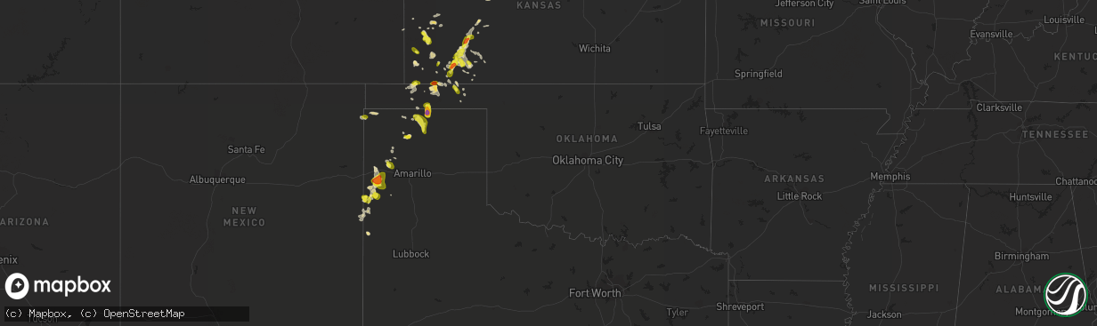
Hail Map in Oklahoma on June 21, 2017
The weather event in Oklahoma on June 21, 2017 includes Hail map. 16 states and 393 cities were impacted and suffered possible damage. The total estimated number of properties impacted is 194.
Want more than just the map?
Turn this storm into a full workflow.
- Owner + property data so you know who to knock
- OnDemand branded weather history reports to win the "did we even have hail?" argument
- RoofTrace estimate so reps stop guessing numbers at the door
Bought this map? Upgrade within 7 days and we'll credit the $230. (10-15 min setup call)
Hail
194
Estimated number of impacted properties by a 1.00" hail or larger26
Estimated number of impacted properties by a 1.75" hail or larger0
Estimated number of impacted properties by a 2.50" hail or largerStorm reports in Oklahoma
Oklahoma
| Date | Description |
|---|---|
| 06/20/20178:55 PM CDT | A local report indicates 62 MPH wind near 8 W SLAPOUT |
| 06/20/20178:50 PM CDT | A local report indicates 69 MPH wind near 8 W SLAPOUT |
| 06/20/20178:40 PM CDT | A local report indicates 63 MPH wind near 1 SSW BEAVER |
| 06/20/20178:38 PM CDT | A local report indicates 58 MPH wind near BALKO |
| 06/20/20178:35 PM CDT | A local report indicates 70 MPH wind near 1 SSW BEAVER |
| 06/20/20178:30 PM CDT | A local report indicates 71 MPH wind near 1 SSW BEAVER |
| 06/20/20177:53 PM CDT | A local report indicates 60 MPH wind near 1 E HOOKER |
| 06/20/20177:33 PM CDT | A local report indicates 1.75 inch wind near 9 NNW HOOKER |
All States Impacted by Hail Map on June 21, 2017
Cities Impacted by Hail Map on June 21, 2017
- Cass Lake, MN
- Laporte, MN
- Ruthven, IA
- Dickens, IA
- Hereford, TX
- Adrian, TX
- Kendall, KS
- Lakin, KS
- Oxford, NE
- De Smet, SD
- Marshall, MN
- Tracy, MN
- Lu Verne, IA
- Kanawha, IA
- Annapolis, IL
- Clayton, NM
- Texline, TX
- Dumas, TX
- Sunray, TX
- Granada, MN
- Winnebago, MN
- Blue Earth, MN
- Hendricks, MN
- Astoria, SD
- Sebeka, MN
- Menahga, MN
- Ulysses, KS
- Alma, NE
- Republican City, NE
- Ingalls, KS
- Copeland, KS
- Pierre, SD
- Fort Pierre, SD
- Sumner, IA
- Tripoli, IA
- Holbrook, NE
- Edison, NE
- Elwood, NE
- Cambridge, NE
- Bertrand, NE
- Arapahoe, NE
- Guymon, OK
- Gruver, TX
- Callaway, NE
- Gothenburg, NE
- Latimer, IA
- Estelline, SD
- Arco, MN
- Hayti, SD
- Clear Lake, SD
- Minneota, MN
- Castlewood, SD
- Brandt, SD
- Toronto, SD
- Ghent, MN
- White, SD
- Lynd, MN
- Ivanhoe, MN
- Walnut Grove, MN
- Hewitt, MN
- Stamford, NE
- Long Island, KS
- Beaver City, NE
- Vega, TX
- Cimarron, KS
- Jetmore, KS
- Liberal, KS
- Burwell, NE
- Elyria, NE
- Blunt, SD
- Deerfield, KS
- Sublette, KS
- Utica, KS
- Ceylon, MN
- Fairmont, MN
- Friona, TX
- Emmetsburg, IA
- Bagley, MN
- Brooks, MN
- Mcintosh, MN
- Oklee, MN
- Greenville, IA
- Webb, IA
- Sioux Rapids, IA
- Winsted, CT
- Riverton, CT
- Barkhamsted, CT
- Walsh, CO
- Tyrone, OK
- Renwick, IA
- Corwith, IA
- Bode, IA
- Livermore, IA
- Frankfort, SD
- Hitchcock, SD
- Redfield, SD
- Tulare, SD
- Tescott, KS
- Salina, KS
- Gaylord, KS
- Mahnomen, MN
- Cloudcroft, NM
- Spirit Lake, IA
- Lakefield, MN
- Jackson, MN
- Concordia, KS
- Hayes, SD
- Milford, IA
- Lake Park, IA
- Miltonvale, KS
- Delphos, KS
- Clear Lake, IA
- Fertile, MN
- Mentor, MN
- Eldora, IA
- Hawkeye, IA
- Nora Springs, IA
- Mason City, IA
- Broken Bow, NE
- Lakota, IA
- Ocheyedan, IA
- Syracuse, KS
- Holly, CO
- Red Cloud, NE
- Breckenridge, MN
- Fergus Falls, MN
- Dalton, MN
- Doland, SD
- Carpenter, SD
- Willow Lake, SD
- Sabin, MN
- Glyndon, MN
- Lake Park, MN
- Hawley, MN
- Hampton, IA
- Chapin, IA
- Aredale, IA
- Sheffield, IA
- Dougherty, IA
- Seneca, SD
- Faulkton, SD
- Goodwell, OK
- Tuckerton, NJ
- Whittemore, IA
- Welcome, MN
- Athol, KS
- Smith Center, KS
- Kensington, KS
- Elida, NM
- Pep, NM
- Turpin, OK
- Buffalo Center, IA
- Burt, IA
- Swea City, IA
- Bancroft, IA
- Fenton, IA
- Lone Rock, IA
- Ledyard, IA
- Armstrong, IA
- Ringsted, IA
- Titonka, IA
- Sherman, ME
- Sherburn, MN
- Gully, MN
- Plains, KS
- Thornton, IA
- Meservey, IA
- Texico, NM
- Farwell, TX
- Alpena, SD
- Artesian, SD
- Letcher, SD
- Woonsocket, SD
- Wessington Springs, SD
- Fedora, SD
- Montezuma, KS
- Sudan, TX
- Fowler, KS
- Bovina, TX
- Midland, SD
- Gonvick, MN
- Hortonville, WI
- Ensign, KS
- Ransom, KS
- Hugoton, KS
- Hooker, OK
- Riverton, NE
- Dalhart, TX
- Waverly, IA
- Nashua, IA
- New Hampton, IA
- Marble Rock, IA
- Fredericksburg, IA
- Clarksville, IA
- Charles City, IA
- Plainfield, IA
- Ionia, IA
- Greene, IA
- Rockwell, IA
- Merrill, IA
- Le Mars, IA
- Gann Valley, SD
- Naytahwaush, MN
- Denver, IA
- Cedar Falls, IA
- Waterloo, IA
- Readlyn, IA
- Fayette, IA
- Oelwein, IA
- Maynard, IA
- Trail, MN
- Henning, MN
- Ottertail, MN
- Deer Creek, MN
- Woden, IA
- Forest City, IA
- Britt, IA
- Clyde, KS
- Meade, KS
- Cedar, KS
- Eustis, NE
- Cozad, NE
- Leoti, KS
- Bladen, NE
- Campbell, NE
- Blue Hill, NE
- Gettysburg, SD
- Hoven, SD
- Inavale, NE
- Elmore, MN
- Hazel, SD
- Watertown, SD
- Cuervo, NM
- Henry, SD
- Clark, SD
- Russell, MN
- Garden City, SD
- Mosquero, NM
- Dolliver, IA
- Estherville, IA
- Dunnell, MN
- Hinton, IA
- Clarion, IA
- Belmond, IA
- Channing, TX
- Stratford, TX
- Aurora, KS
- Crookston, MN
- Beltrami, MN
- Erskine, MN
- Clearbrook, MN
- Plummer, MN
- Phillipsburg, KS
- Erwin, SD
- Mount Pleasant, MI
- Shepherd, MI
- Texhoma, OK
- Staples, MN
- Shell Rock, IA
- Hays, KS
- Bloomington, NE
- Minneola, KS
- Bemidji, MN
- Johnson, KS
- Fairbank, IA
- Lake Crystal, MN
- Nelson, MN
- Wiley, CO
- Lamar, CO
- Ayrshire, IA
- Agra, KS
- Ogallah, KS
- Huron, SD
- Shevlin, MN
- Hartley, IA
- Grundy Center, IA
- Harrold, SD
- Grenville, NM
- Moorhead, MN
- Hitterdal, MN
- Sibley, IA
- Harris, IA
- Janesville, IA
- Kismet, KS
- Carlos, MN
- Alexandria, MN
- Onida, SD
- Satanta, KS
- Highmore, SD
- Audubon, MN
- Ottosen, IA
- Bradgate, IA
- Rutland, IA
- Union Center, SD
- Wadena, IA
- Rothsay, MN
- Richfield, KS
- Forgan, OK
- Swaledale, IA
- Remsen, IA
- Kingsley, IA
- Pierson, IA
- Marcus, IA
- Richville, MN
- New York Mills, MN
- Roy, NM
- Cherry Creek, SD
- Beaver, OK
- Fertile, IA
- Thompson, IA
- Leland, IA
- Dupree, SD
- Randalia, IA
- Arlington, IA
- Westgate, IA
- West Union, IA
- Elgin, IA
- Rockham, SD
- Moscow, KS
- Allison, IA
- Randolph, NE
- Clovis, NM
- Dixon, NE
- Spearman, TX
- Franklin, NE
- Howard, SD
- Ree Heights, SD
- Moville, IA
- Klemme, IA
- Laurel, NE
- Sedan, NM
- Tolstoy, SD
- Onaka, SD
- Iroquois, SD
- Madelia, MN
- Coulter, IA
- Alexander, IA
- Rowan, IA
- Dows, IA
- Brady, NE
- Dumont, IA
- Aplington, IA
- Balko, OK
- Rockford, IA
- Portales, NM
- Melvin, IA
- Orleans, NE
- Elizabeth, MN
- Monticello, NM
- Lawton, IA
- Parkersburg, IA
- Coleridge, NE
- Hartington, NE
- Dunkerton, IA
- Midland, MI
- Saint Louis, MI
- Ackley, IA
- Geneva, IA
- Bertha, MN
- Tucumcari, NM
- Alpha, MN
- Garner, IA
- Grainfield, KS
- Holcomb, KS
- Verndale, MN
- Brownsville, MN
- Lengby, MN
- Thief River Falls, MN
- Lebanon, KS
- Saunderstown, RI
- Exeter, RI
- Holdrege, NE
- Battle Lake, MN
- West Creek, NJ
- Beach Haven, NJ
- Callaway, MN
- Detroit Lakes, MN
- Foxhome, MN
- Twin Valley, MN
- Waubun, MN
- Canton, CT
- West Simsbury, CT
- West Granby, CT
- Simsbury, CT
- Colebrook, CT
- Broadview, NM
- Morse, TX
- Lower Brule, SD
- Milroy, MN
- Revere, MN
- Lucan, MN
- Miller, SD
- Rolla, KS


