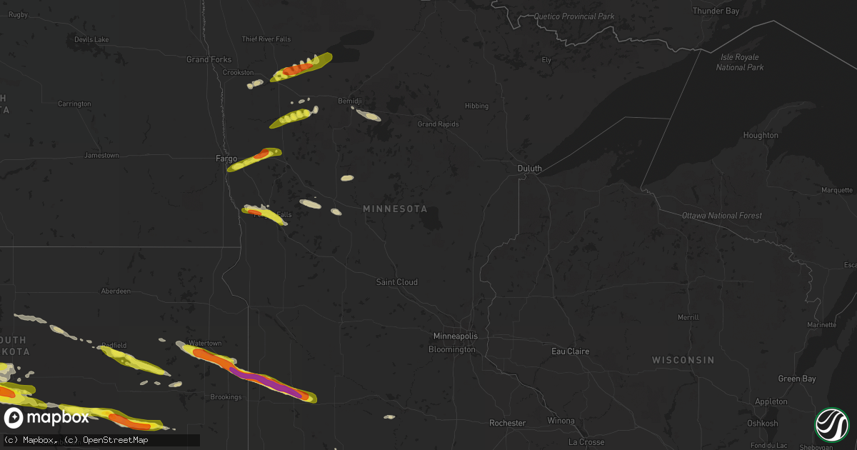
Hail Map in Minnesota on June 21, 2017
Get this storm
June 21 map
$229
one time, instant access
Download today. No call, no setup
Keep the $229
Bought the map and want the full workflow? Apply the entire $229 to a subscription within 7 days. None of it is wasted.
Every map, not just this one
This buys you this map. Subscription and you get every map we run, in the markets you choose from a few cities to whole states to nationwide. Plus real-time alerts the moment a storm fires.
Contact data
Name, contact info, occupancy, even credit band for addresses in the footprint. You go from where it hit to who to call.
Become the source they trust
Unlimited branding weather history reports on demand. You already have the documented answer ready for the property owner, and you are the one who showed up with it.
Property data and RoofTrace estimates
Pull up any address you have got, its value and the exact code rules for that jurisdiction, straight from One Click Code. Then RoofTrace estimates the squares, pitch, and roof value, priced the way you price.
Storm reports in Minnesota
Minnesota
| Date | Description |
|---|---|
| 06/21/20176:54 PM CDT | Peak wind measured at the fergus falls airport. |
| 06/21/20176:54 PM CDT | Peak wind measured at the fergus falls airport. |
| 06/21/20176:50 PM CDT | Vehicle blown off the road. |
| 06/21/20176:40 PM CDT | A few large 3 to 5 inch diameter branches down along with a number of dime to nickel sized hail. |
| 06/21/20176:39 PM CDT | Multiple witnesses to tornado touchdown. Tornado was rain wrapped at the time of touchdown. |
| 06/21/20176:39 PM CDT | The tornado touchdown was viewed and photographed though it was enshrouded in either dust or rain at times. This tornado appeared to track intermittently for about 1.5 |
| 06/21/20176:35 PM CDT | Nickel to quarter sized hail. Report posted via social media. |
| 06/21/20176:24 PM CDT | Video and photographic evidence show that this tornado touched down and tracked to the east southeast over open fields for a half mile of less...and ended by around 625 |
| 06/21/20176:22 PM CDT | A local report indicates 1.00 inch wind near 4 NNW LAKE PARK |
| 06/21/20176:15 PM CDT | Lots of dime to quarter sized hail. |
| 06/21/20174:56 AM CDT | A local report indicates 1.00 inch wind near 8 NNW TRACY |
| 06/21/20174:52 AM CDT | Broke windows. |
| 06/21/20174:52 AM CDT | A local report indicates 2.00 inch wind near 8 SSE MARSHALL |
| 06/21/20174:42 AM CDT | Tree damage as well. |
| 06/21/20174:35 AM CDT | A local report indicates 1.75 inch wind near 1 ENE LYND |
| 06/21/20174:10 AM CDT | A local report indicates 1.75 inch wind near 2 NNW IVANHOE |
| 06/21/20173:57 AM CDT | A local report indicates 1.75 inch wind near HENDRICKS |
| 06/21/201712:05 AM CDT | A local report indicates 1.25 inch wind near WELCOME |
| 06/20/20177:27 PM CDT | A local report indicates 1.25 inch wind near 3 N MAHKONCE |
| 06/20/20177:08 PM CDT | A couple of trees were split and broken down across power lines resulting in local power outages. Time estimated based on radar and nearby wind observations. |
| 06/20/20177:05 PM CDT | Dime to quarter sized hail fell across southern dane prairie township. Some smaller tree branches broken down. |
| 06/20/20177:04 PM CDT | A large evergreen tree was snapped about halfway down. Report posted via social media. Power outages occurred across the area. |
| 06/20/20177:01 PM CDT | Peak winds measured at the prairie wetlands learning center. |
All States Impacted by Hail Map on June 21, 2017
Cities Impacted by Hail Map on June 21, 2017
- Cass Lake, MN
- Laporte, MN
- Ruthven, IA
- Dickens, IA
- Hereford, TX
- Adrian, TX
- Kendall, KS
- Lakin, KS
- Oxford, NE
- De Smet, SD
- Marshall, MN
- Tracy, MN
- Lu Verne, IA
- Kanawha, IA
- Annapolis, IL
- Clayton, NM
- Texline, TX
- Dumas, TX
- Sunray, TX
- Granada, MN
- Winnebago, MN
- Blue Earth, MN
- Hendricks, MN
- Astoria, SD
- Sebeka, MN
- Menahga, MN
- Ulysses, KS
- Alma, NE
- Republican City, NE
- Ingalls, KS
- Copeland, KS
- Pierre, SD
- Fort Pierre, SD
- Sumner, IA
- Tripoli, IA
- Holbrook, NE
- Edison, NE
- Elwood, NE
- Cambridge, NE
- Bertrand, NE
- Arapahoe, NE
- Guymon, OK
- Gruver, TX
- Callaway, NE
- Gothenburg, NE
- Latimer, IA
- Estelline, SD
- Arco, MN
- Hayti, SD
- Clear Lake, SD
- Minneota, MN
- Castlewood, SD
- Brandt, SD
- Toronto, SD
- Ghent, MN
- White, SD
- Lynd, MN
- Ivanhoe, MN
- Walnut Grove, MN
- Hewitt, MN
- Stamford, NE
- Long Island, KS
- Beaver City, NE
- Vega, TX
- Cimarron, KS
- Jetmore, KS
- Liberal, KS
- Burwell, NE
- Elyria, NE
- Blunt, SD
- Deerfield, KS
- Sublette, KS
- Utica, KS
- Ceylon, MN
- Fairmont, MN
- Friona, TX
- Emmetsburg, IA
- Bagley, MN
- Brooks, MN
- Mcintosh, MN
- Oklee, MN
- Greenville, IA
- Webb, IA
- Sioux Rapids, IA
- Winsted, CT
- Riverton, CT
- Barkhamsted, CT
- Walsh, CO
- Tyrone, OK
- Renwick, IA
- Corwith, IA
- Bode, IA
- Livermore, IA
- Frankfort, SD
- Hitchcock, SD
- Redfield, SD
- Tulare, SD
- Tescott, KS
- Salina, KS
- Gaylord, KS
- Mahnomen, MN
- Cloudcroft, NM
- Spirit Lake, IA
- Lakefield, MN
- Jackson, MN
- Concordia, KS
- Hayes, SD
- Milford, IA
- Lake Park, IA
- Miltonvale, KS
- Delphos, KS
- Clear Lake, IA
- Fertile, MN
- Mentor, MN
- Eldora, IA
- Hawkeye, IA
- Nora Springs, IA
- Mason City, IA
- Broken Bow, NE
- Lakota, IA
- Ocheyedan, IA
- Syracuse, KS
- Holly, CO
- Red Cloud, NE
- Breckenridge, MN
- Fergus Falls, MN
- Dalton, MN
- Doland, SD
- Carpenter, SD
- Willow Lake, SD
- Sabin, MN
- Glyndon, MN
- Lake Park, MN
- Hawley, MN
- Hampton, IA
- Chapin, IA
- Aredale, IA
- Sheffield, IA
- Dougherty, IA
- Seneca, SD
- Faulkton, SD
- Goodwell, OK
- Tuckerton, NJ
- Whittemore, IA
- Welcome, MN
- Athol, KS
- Smith Center, KS
- Kensington, KS
- Elida, NM
- Pep, NM
- Turpin, OK
- Buffalo Center, IA
- Burt, IA
- Swea City, IA
- Bancroft, IA
- Fenton, IA
- Lone Rock, IA
- Ledyard, IA
- Armstrong, IA
- Ringsted, IA
- Titonka, IA
- Sherman, ME
- Sherburn, MN
- Gully, MN
- Plains, KS
- Thornton, IA
- Meservey, IA
- Texico, NM
- Farwell, TX
- Alpena, SD
- Artesian, SD
- Letcher, SD
- Woonsocket, SD
- Wessington Springs, SD
- Fedora, SD
- Montezuma, KS
- Sudan, TX
- Fowler, KS
- Bovina, TX
- Midland, SD
- Gonvick, MN
- Hortonville, WI
- Ensign, KS
- Ransom, KS
- Hugoton, KS
- Hooker, OK
- Riverton, NE
- Dalhart, TX
- Waverly, IA
- Nashua, IA
- New Hampton, IA
- Marble Rock, IA
- Fredericksburg, IA
- Clarksville, IA
- Charles City, IA
- Plainfield, IA
- Ionia, IA
- Greene, IA
- Rockwell, IA
- Merrill, IA
- Le Mars, IA
- Gann Valley, SD
- Naytahwaush, MN
- Denver, IA
- Cedar Falls, IA
- Waterloo, IA
- Readlyn, IA
- Fayette, IA
- Oelwein, IA
- Maynard, IA
- Trail, MN
- Henning, MN
- Ottertail, MN
- Deer Creek, MN
- Woden, IA
- Forest City, IA
- Britt, IA
- Clyde, KS
- Meade, KS
- Cedar, KS
- Eustis, NE
- Cozad, NE
- Leoti, KS
- Bladen, NE
- Campbell, NE
- Blue Hill, NE
- Gettysburg, SD
- Hoven, SD
- Inavale, NE
- Elmore, MN
- Hazel, SD
- Watertown, SD
- Cuervo, NM
- Henry, SD
- Clark, SD
- Russell, MN
- Garden City, SD
- Mosquero, NM
- Dolliver, IA
- Estherville, IA
- Dunnell, MN
- Hinton, IA
- Clarion, IA
- Belmond, IA
- Channing, TX
- Stratford, TX
- Aurora, KS
- Crookston, MN
- Beltrami, MN
- Erskine, MN
- Clearbrook, MN
- Plummer, MN
- Phillipsburg, KS
- Erwin, SD
- Mount Pleasant, MI
- Shepherd, MI
- Texhoma, OK
- Staples, MN
- Shell Rock, IA
- Hays, KS
- Bloomington, NE
- Minneola, KS
- Bemidji, MN
- Johnson, KS
- Fairbank, IA
- Lake Crystal, MN
- Nelson, MN
- Wiley, CO
- Lamar, CO
- Ayrshire, IA
- Agra, KS
- Ogallah, KS
- Huron, SD
- Shevlin, MN
- Hartley, IA
- Grundy Center, IA
- Harrold, SD
- Grenville, NM
- Moorhead, MN
- Hitterdal, MN
- Sibley, IA
- Harris, IA
- Janesville, IA
- Kismet, KS
- Carlos, MN
- Alexandria, MN
- Onida, SD
- Satanta, KS
- Highmore, SD
- Audubon, MN
- Ottosen, IA
- Bradgate, IA
- Rutland, IA
- Union Center, SD
- Wadena, IA
- Rothsay, MN
- Richfield, KS
- Forgan, OK
- Swaledale, IA
- Remsen, IA
- Kingsley, IA
- Pierson, IA
- Marcus, IA
- Richville, MN
- New York Mills, MN
- Roy, NM
- Cherry Creek, SD
- Beaver, OK
- Fertile, IA
- Thompson, IA
- Leland, IA
- Dupree, SD
- Randalia, IA
- Arlington, IA
- Westgate, IA
- West Union, IA
- Elgin, IA
- Rockham, SD
- Moscow, KS
- Allison, IA
- Randolph, NE
- Clovis, NM
- Dixon, NE
- Spearman, TX
- Franklin, NE
- Howard, SD
- Ree Heights, SD
- Moville, IA
- Klemme, IA
- Laurel, NE
- Sedan, NM
- Tolstoy, SD
- Onaka, SD
- Iroquois, SD
- Madelia, MN
- Coulter, IA
- Alexander, IA
- Rowan, IA
- Dows, IA
- Brady, NE
- Dumont, IA
- Aplington, IA
- Balko, OK
- Rockford, IA
- Portales, NM
- Melvin, IA
- Orleans, NE
- Elizabeth, MN
- Monticello, NM
- Lawton, IA
- Parkersburg, IA
- Coleridge, NE
- Hartington, NE
- Dunkerton, IA
- Midland, MI
- Saint Louis, MI
- Ackley, IA
- Geneva, IA
- Bertha, MN
- Tucumcari, NM
- Alpha, MN
- Garner, IA
- Grainfield, KS
- Holcomb, KS
- Verndale, MN
- Brownsville, MN
- Lengby, MN
- Thief River Falls, MN
- Lebanon, KS
- Saunderstown, RI
- Exeter, RI
- Holdrege, NE
- Battle Lake, MN
- West Creek, NJ
- Beach Haven, NJ
- Callaway, MN
- Detroit Lakes, MN
- Foxhome, MN
- Twin Valley, MN
- Waubun, MN
- Canton, CT
- West Simsbury, CT
- West Granby, CT
- Simsbury, CT
- Colebrook, CT
- Broadview, NM
- Morse, TX
- Lower Brule, SD
- Milroy, MN
- Revere, MN
- Lucan, MN
- Miller, SD
- Rolla, KS


