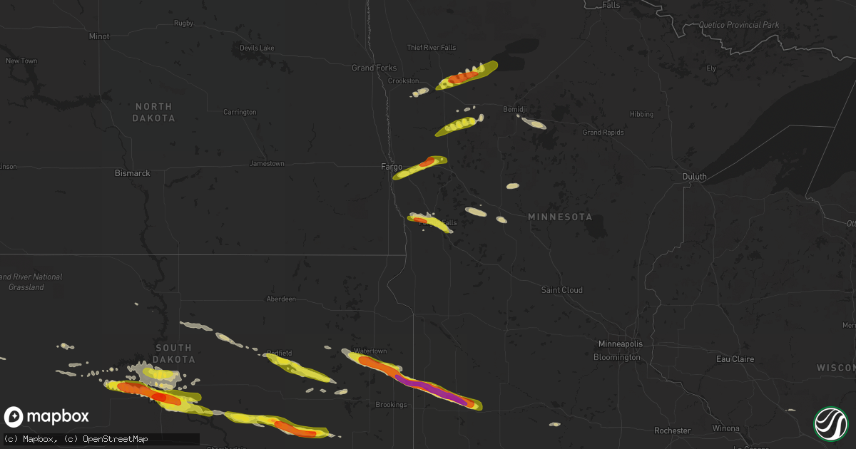
Hail Map on June 21, 2017
Get this storm
June 21 map
$229
one time, instant access
Download today. No call, no setup
Keep the $229
Bought the map and want the full workflow? Apply the entire $229 to a subscription within 7 days. None of it is wasted.
Every map, not just this one
This buys you this map. Subscription and you get every map we run, in the markets you choose from a few cities to whole states to nationwide. Plus real-time alerts the moment a storm fires.
Contact data
Name, contact info, occupancy, even credit band for addresses in the footprint. You go from where it hit to who to call.
Become the source they trust
Unlimited branding weather history reports on demand. You already have the documented answer ready for the property owner, and you are the one who showed up with it.
Property data and RoofTrace estimates
Pull up any address you have got, its value and the exact code rules for that jurisdiction, straight from One Click Code. Then RoofTrace estimates the squares, pitch, and roof value, priced the way you price.
States Impacted by Hail Map on June 21, 2017
Storm reports
Mississippi
| Date | Description |
|---|---|
| 06/21/20178:38 AM CDT | Two tornadoes spotted near woolmarket rd |
| 06/21/20178:30 AM CDT | Two tornadoes spotted near woolmarket rd. Tree... Powerline... And fence damage in the vicinity of beauvoir rd... Rich ave... And popps ferry rd |
Oklahoma
| Date | Description |
|---|---|
| 06/20/20178:55 PM CDT | A local report indicates 62 MPH wind near 8 W SLAPOUT |
| 06/20/20178:50 PM CDT | A local report indicates 69 MPH wind near 8 W SLAPOUT |
| 06/20/20178:40 PM CDT | A local report indicates 63 MPH wind near 1 SSW BEAVER |
| 06/20/20178:38 PM CDT | A local report indicates 58 MPH wind near BALKO |
| 06/20/20178:35 PM CDT | A local report indicates 70 MPH wind near 1 SSW BEAVER |
| 06/20/20178:30 PM CDT | A local report indicates 71 MPH wind near 1 SSW BEAVER |
| 06/20/20177:53 PM CDT | A local report indicates 60 MPH wind near 1 E HOOKER |
| 06/20/20177:33 PM CDT | A local report indicates 1.75 inch wind near 9 NNW HOOKER |
New Jersey
| Date | Description |
|---|---|
| 06/21/20175:05 PM CDT | Some trees down. Time estimated from radar. |
| 06/21/20174:54 PM CDT | Tree fell on a car... Time estimated |
| 06/21/20174:33 PM CDT | Large trees down on house and a car... Time estimated |
| 06/21/20174:28 PM CDT | Tress and powerlines down... Time estimated |
| 06/21/20174:27 PM CDT | Trees and powerlines down... Time estimated |
| 06/21/20174:20 PM CDT | Top half blown off large magnolia tree. Time estimated from radar. |
| 06/21/20174:15 PM CDT | Large tree limbs down and fence damage |
| 06/21/20174:12 PM CDT | Large tree down and blocking on isacc budd rd... Time estimated |
| 06/21/20174:09 PM CDT | Several tress down... Time estimated |
| 06/21/20174:08 PM CDT | Mount holly twp... Several trees down... Time estimated |
| 06/21/20174:07 PM CDT | Tress down... One on a tracker trailer... Time estimated |
| 06/21/20174:05 PM CDT | Several large trees down... Time estimated |
| 06/21/20174:02 PM CDT | Trees down on mount laurel rd... Time estimated |
| 06/21/20174:00 PM CDT | Trees and wires down... Time estimated |
| 06/21/20173:59 PM CDT | Several trees down... Time estimated |
| 06/21/20173:56 PM CDT | Large branch down... Time estimated |
| 06/21/20173:54 PM CDT | Large tree limb snapped... Time estimated |
| 06/21/20173:53 PM CDT | Tree down... Time estimated |
| 06/21/20173:50 PM CDT | Large branch down on some wires... Time estimated |
Nevada
| Date | Description |
|---|---|
| 06/20/20177:15 PM CDT | Minden awos station reported a thunderstorm gust of 59 mph. |
South Dakota
| Date | Description |
|---|---|
| 06/21/20175:35 AM CDT | A local report indicates 1.25 inch wind near ARTESIAN |
| 06/21/20175:30 AM CDT | A local report indicates 1.75 inch wind near 3 WSW ARTESIAN |
| 06/21/20175:19 AM CDT | A local report indicates 1.00 inch wind near 2 NNE PIERRE |
| 06/21/20175:00 AM CDT | Strong winds estimated around 40 mph as well... But no noticeable damage. |
| 06/21/20174:52 AM CDT | A local report indicates 1.75 inch wind near WESSINGTON SPRINGS |
| 06/21/20174:35 AM CDT | Estimated winds of at least 60 mph. Hay bales blown over. Time based on radar. |
| 06/21/20173:51 AM CDT | Destroyed crops and damaged homes in astoria. |
| 06/21/20173:48 AM CDT | Layed-over corn and hail drifts. |
| 06/21/20173:40 AM CDT | No damage noticeable. Time based on radar. |
| 06/21/20173:20 AM CDT | A local report indicates 1.00 inch wind near CASTLEWOOD |
| 06/21/20173:10 AM CDT | Multiple trees downed blocking intersection of highways 81 and 22 at kones corner. Correction to previous report for location. |
| 06/21/20173:10 AM CDT | Multiple trees downed blocking intersection of highways 81 and 22 at kones corner. |
| 06/21/20173:09 AM CDT | 16 to 20 power poles down. Power outages as well. |
| 06/21/20173:08 AM CDT | A local report indicates 1.75 inch wind near 3 NE PIERRE |
Minnesota
| Date | Description |
|---|---|
| 06/21/20176:54 PM CDT | Peak wind measured at the fergus falls airport. |
| 06/21/20176:54 PM CDT | Peak wind measured at the fergus falls airport. |
| 06/21/20176:50 PM CDT | Vehicle blown off the road. |
| 06/21/20176:40 PM CDT | A few large 3 to 5 inch diameter branches down along with a number of dime to nickel sized hail. |
| 06/21/20176:39 PM CDT | The tornado touchdown was viewed and photographed though it was enshrouded in either dust or rain at times. This tornado appeared to track intermittently for about 1.5 |
| 06/21/20176:39 PM CDT | Multiple witnesses to tornado touchdown. Tornado was rain wrapped at the time of touchdown. |
| 06/21/20176:35 PM CDT | Nickel to quarter sized hail. Report posted via social media. |
| 06/21/20176:24 PM CDT | Video and photographic evidence show that this tornado touched down and tracked to the east southeast over open fields for a half mile of less...and ended by around 625 |
| 06/21/20176:22 PM CDT | A local report indicates 1.00 inch wind near 4 NNW LAKE PARK |
| 06/21/20176:15 PM CDT | Lots of dime to quarter sized hail. |
| 06/21/20174:56 AM CDT | A local report indicates 1.00 inch wind near 8 NNW TRACY |
| 06/21/20174:52 AM CDT | Broke windows. |
| 06/21/20174:52 AM CDT | A local report indicates 2.00 inch wind near 8 SSE MARSHALL |
| 06/21/20174:42 AM CDT | Tree damage as well. |
| 06/21/20174:35 AM CDT | A local report indicates 1.75 inch wind near 1 ENE LYND |
| 06/21/20174:10 AM CDT | A local report indicates 1.75 inch wind near 2 NNW IVANHOE |
| 06/21/20173:57 AM CDT | A local report indicates 1.75 inch wind near HENDRICKS |
| 06/21/201712:05 AM CDT | A local report indicates 1.25 inch wind near WELCOME |
| 06/20/20177:27 PM CDT | A local report indicates 1.25 inch wind near 3 N MAHKONCE |
| 06/20/20177:08 PM CDT | A couple of trees were split and broken down across power lines resulting in local power outages. Time estimated based on radar and nearby wind observations. |
| 06/20/20177:05 PM CDT | Dime to quarter sized hail fell across southern dane prairie township. Some smaller tree branches broken down. |
| 06/20/20177:04 PM CDT | A large evergreen tree was snapped about halfway down. Report posted via social media. Power outages occurred across the area. |
| 06/20/20177:01 PM CDT | Peak winds measured at the prairie wetlands learning center. |
Colorado
| Date | Description |
|---|---|
| 06/21/20176:30 PM CDT | A tree branch about 2.50 to 3.00 inches in diameter broke off and fell in the wilson ranch park area as a result of downburst winds. |
| 06/21/20176:30 PM CDT | Several tree branches 2.5 to 3 inches in diameter broke off and fell to the ground as a result of downburst winds. |
| 06/21/20175:29 PM CDT | Mesonet station co104... 2 s woody creek. |
| 06/20/20177:12 PM CDT | 55 gallon drum full of fuel was blown over and into a parked vehicle. |
Pennsylvania
| Date | Description |
|---|---|
| 06/21/20173:58 PM CDT | Large tree down... Time estimated |
| 06/21/20173:46 PM CDT | A local report indicates 65 MPH wind near FISHTOWN |
| 06/21/20173:45 PM CDT | Trees down... Time estimated |
| 06/21/20173:42 PM CDT | Large tree limbs down |
| 06/21/20173:35 PM CDT | Numerous large trees down... Time estimated |
| 06/21/20173:33 PM CDT | Time estimated |
| 06/21/20173:32 PM CDT | Several winds and trees blown down |
| 06/21/20173:26 PM CDT | Large branches down... Time estimated |
| 06/21/20173:14 PM CDT | Several trees and wires blown down. |
| 06/21/20173:14 PM CDT | Two large limbs down... Time estimated |
| 06/21/20173:12 PM CDT | Tress and wires down... Time estimated |
| 06/21/20173:03 PM CDT | Several trees and wires down |
| 06/21/20173:00 PM CDT | Tress and powerlines down with damage to some homes... Winds 70+mph... Time estimated |
Utah
| Date | Description |
|---|---|
| 06/21/20173:26 PM CDT | Mesonet station kpru1... Kings point - 26 wsw hiawatha. |
Kansas
| Date | Description |
|---|---|
| 06/21/20176:50 PM CDT | A local report indicates 60 MPH wind near 8 NNE COPELAND |
| 06/21/20176:45 PM CDT | A local report indicates 1.00 inch wind near 2 SW INGALLS |
| 06/21/20176:45 PM CDT | A local report indicates 60 MPH wind near 5 S INGALLS |
| 06/21/20176:35 PM CDT | Reported at gck. |
| 06/21/20176:30 PM CDT | A local report indicates 60 MPH wind near 10 WSW KALVESTA |
| 06/21/20176:15 PM CDT | A local report indicates 60 MPH wind near 5 SW ULYSSES |
| 06/21/20175:45 PM CDT | A local report indicates 61 MPH wind near 4 SSE LAKIN |
| 06/21/20175:32 PM CDT | A local report indicates 60 MPH wind near 1 E KENDALL |
| 06/20/20177:38 PM CDT | A local report indicates 60 MPH wind near KISMET |
| 06/20/20177:35 PM CDT | A local report indicates 60 MPH wind near 3 S PLAINS CITY |
| 06/20/20177:15 PM CDT | Awos station hqg... Hugoton. |
| 06/20/20177:15 PM CDT | A local report indicates 65 MPH wind near ENSIGN |
| 06/20/20177:00 PM CDT | Emergency manager reported several telephone poles blown down at 8 road and cc road. |
Alabama
| Date | Description |
|---|---|
| 06/21/20175:27 PM CDT | Trees down across dawes lane near three notch rd |
| 06/21/20175:12 PM CDT | Reports of trees down across highway 188 near dauphin island parkway. |
| 06/21/20172:55 PM CDT | Trees and powerlines down. Some minor damage to homes on state hwy 59. |
| 06/21/20171:10 AM CDT | Power outage due to trees. Also public estimated wind gusts of 55-60 mph in the area |
| 06/20/20177:10 PM CDT | Law enforcement and public reported a tornado north of onycha moving north |
Nebraska
| Date | Description |
|---|---|
| 06/20/20179:42 PM CDT | Hail ongoing and continued for a few more minutes. |
| 06/20/20178:38 PM CDT | Quarter sized hail with est wind gusts to 60 mph. |
| 06/20/20178:30 PM CDT | Mostly peas and dimes with a few quarters mixed in. |
| 06/20/20178:21 PM CDT | A local report indicates 1.00 inch wind near 4 WSW BROKEN BOW |
Florida
| Date | Description |
|---|---|
| 06/21/20176:41 PM CDT | Trees down... Powerlines down...and cosmetic damage to homes near aquamarine ave and emerald ave. |
| 06/21/20176:39 PM CDT | Trees down... Powerlines down...and cosmetic damage to homes near north kirk st and west brainerd st. |
Texas
| Date | Description |
|---|---|
| 06/21/20176:58 PM CDT | A local report indicates 58 MPH wind near 7 ENE VALLEY DE ORO |
| 06/21/20176:16 PM CDT | A local report indicates 59 MPH wind near 1 WSW BOYS RANCH |
| 06/21/20174:00 PM CDT | A local report indicates 1.00 inch wind near TEXLINE |
| 06/20/201710:35 PM CDT | Late report....thunderstorm wind gust 60-70 mph. Gust consitently high between 1030-1100pm. |
| 06/20/201710:08 PM CDT | A local report indicates 63 MPH wind near MORSE |
| 06/20/20179:55 PM CDT | Late report....thunderstorm wind gust 60-70 mph. Gust consitently high between 945-1000pm |
| 06/20/20179:32 PM CDT | Late report...thunderstorm wind gusts between 65 to 70 mph was reported. |
| 06/20/20179:13 PM CDT | A local report indicates 65 MPH wind near 17 S TEXHOMA |
| 06/20/20178:55 PM CDT | A local report indicates 59 MPH wind near 3 ENE PERRYTON |
| 06/20/20178:26 PM CDT | Late report...thunderstorm wind gusts between 60 to 70 mph reported by trained spotter. |
| 06/20/20178:20 PM CDT | Severe wind gusts from 820-830 pm. Sustained winds in excess of 50 mph 825 and 830 pm obs. |
| 06/20/20177:10 PM CDT | Late report...half dollar sized hail reported. |
| 06/20/20177:05 PM CDT | Late report...half dollar sized hail reported. |
Iowa
| Date | Description |
|---|---|
| 06/20/201710:50 PM CDT | A local report indicates 1.00 inch wind near 4 ENE SIBLEY |
Connecticut
| Date | Description |
|---|---|
| 06/21/20173:02 PM CDT | Trained spotter |
Cities Impacted by Hail Map on June 21, 2017
- Cass Lake, MN
- Laporte, MN
- Ruthven, IA
- Dickens, IA
- Hereford, TX
- Adrian, TX
- Kendall, KS
- Lakin, KS
- Oxford, NE
- De Smet, SD
- Marshall, MN
- Tracy, MN
- Lu Verne, IA
- Kanawha, IA
- Annapolis, IL
- Clayton, NM
- Texline, TX
- Dumas, TX
- Sunray, TX
- Granada, MN
- Winnebago, MN
- Blue Earth, MN
- Hendricks, MN
- Astoria, SD
- Sebeka, MN
- Menahga, MN
- Ulysses, KS
- Alma, NE
- Republican City, NE
- Ingalls, KS
- Copeland, KS
- Pierre, SD
- Fort Pierre, SD
- Sumner, IA
- Tripoli, IA
- Holbrook, NE
- Edison, NE
- Elwood, NE
- Cambridge, NE
- Bertrand, NE
- Arapahoe, NE
- Guymon, OK
- Gruver, TX
- Callaway, NE
- Gothenburg, NE
- Latimer, IA
- Estelline, SD
- Arco, MN
- Hayti, SD
- Clear Lake, SD
- Minneota, MN
- Castlewood, SD
- Brandt, SD
- Toronto, SD
- Ghent, MN
- White, SD
- Lynd, MN
- Ivanhoe, MN
- Walnut Grove, MN
- Hewitt, MN
- Stamford, NE
- Long Island, KS
- Beaver City, NE
- Vega, TX
- Cimarron, KS
- Jetmore, KS
- Liberal, KS
- Burwell, NE
- Elyria, NE
- Blunt, SD
- Deerfield, KS
- Sublette, KS
- Utica, KS
- Ceylon, MN
- Fairmont, MN
- Friona, TX
- Emmetsburg, IA
- Bagley, MN
- Brooks, MN
- Mcintosh, MN
- Oklee, MN
- Greenville, IA
- Webb, IA
- Sioux Rapids, IA
- Winsted, CT
- Riverton, CT
- Barkhamsted, CT
- Walsh, CO
- Tyrone, OK
- Renwick, IA
- Corwith, IA
- Bode, IA
- Livermore, IA
- Frankfort, SD
- Hitchcock, SD
- Redfield, SD
- Tulare, SD
- Tescott, KS
- Salina, KS
- Gaylord, KS
- Mahnomen, MN
- Cloudcroft, NM
- Spirit Lake, IA
- Lakefield, MN
- Jackson, MN
- Concordia, KS
- Hayes, SD
- Milford, IA
- Lake Park, IA
- Miltonvale, KS
- Delphos, KS
- Clear Lake, IA
- Fertile, MN
- Mentor, MN
- Eldora, IA
- Hawkeye, IA
- Nora Springs, IA
- Mason City, IA
- Broken Bow, NE
- Lakota, IA
- Ocheyedan, IA
- Syracuse, KS
- Holly, CO
- Red Cloud, NE
- Breckenridge, MN
- Fergus Falls, MN
- Dalton, MN
- Doland, SD
- Carpenter, SD
- Willow Lake, SD
- Sabin, MN
- Glyndon, MN
- Lake Park, MN
- Hawley, MN
- Hampton, IA
- Chapin, IA
- Aredale, IA
- Sheffield, IA
- Dougherty, IA
- Seneca, SD
- Faulkton, SD
- Goodwell, OK
- Tuckerton, NJ
- Whittemore, IA
- Welcome, MN
- Athol, KS
- Smith Center, KS
- Kensington, KS
- Elida, NM
- Pep, NM
- Turpin, OK
- Buffalo Center, IA
- Burt, IA
- Swea City, IA
- Bancroft, IA
- Fenton, IA
- Lone Rock, IA
- Ledyard, IA
- Armstrong, IA
- Ringsted, IA
- Titonka, IA
- Sherman, ME
- Sherburn, MN
- Gully, MN
- Plains, KS
- Thornton, IA
- Meservey, IA
- Texico, NM
- Farwell, TX
- Alpena, SD
- Artesian, SD
- Letcher, SD
- Woonsocket, SD
- Wessington Springs, SD
- Fedora, SD
- Montezuma, KS
- Sudan, TX
- Fowler, KS
- Bovina, TX
- Midland, SD
- Gonvick, MN
- Hortonville, WI
- Ensign, KS
- Ransom, KS
- Hugoton, KS
- Hooker, OK
- Riverton, NE
- Dalhart, TX
- Waverly, IA
- Nashua, IA
- New Hampton, IA
- Marble Rock, IA
- Fredericksburg, IA
- Clarksville, IA
- Charles City, IA
- Plainfield, IA
- Ionia, IA
- Greene, IA
- Rockwell, IA
- Merrill, IA
- Le Mars, IA
- Gann Valley, SD
- Naytahwaush, MN
- Denver, IA
- Cedar Falls, IA
- Waterloo, IA
- Readlyn, IA
- Fayette, IA
- Oelwein, IA
- Maynard, IA
- Trail, MN
- Henning, MN
- Ottertail, MN
- Deer Creek, MN
- Woden, IA
- Forest City, IA
- Britt, IA
- Clyde, KS
- Meade, KS
- Cedar, KS
- Eustis, NE
- Cozad, NE
- Leoti, KS
- Bladen, NE
- Campbell, NE
- Blue Hill, NE
- Gettysburg, SD
- Hoven, SD
- Inavale, NE
- Elmore, MN
- Hazel, SD
- Watertown, SD
- Cuervo, NM
- Henry, SD
- Clark, SD
- Russell, MN
- Garden City, SD
- Mosquero, NM
- Dolliver, IA
- Estherville, IA
- Dunnell, MN
- Hinton, IA
- Clarion, IA
- Belmond, IA
- Channing, TX
- Stratford, TX
- Aurora, KS
- Crookston, MN
- Beltrami, MN
- Erskine, MN
- Clearbrook, MN
- Plummer, MN
- Phillipsburg, KS
- Erwin, SD
- Mount Pleasant, MI
- Shepherd, MI
- Texhoma, OK
- Staples, MN
- Shell Rock, IA
- Hays, KS
- Bloomington, NE
- Minneola, KS
- Bemidji, MN
- Johnson, KS
- Fairbank, IA
- Lake Crystal, MN
- Nelson, MN
- Wiley, CO
- Lamar, CO
- Ayrshire, IA
- Agra, KS
- Ogallah, KS
- Huron, SD
- Shevlin, MN
- Hartley, IA
- Grundy Center, IA
- Harrold, SD
- Grenville, NM
- Moorhead, MN
- Hitterdal, MN
- Sibley, IA
- Harris, IA
- Janesville, IA
- Kismet, KS
- Carlos, MN
- Alexandria, MN
- Onida, SD
- Satanta, KS
- Highmore, SD
- Audubon, MN
- Ottosen, IA
- Bradgate, IA
- Rutland, IA
- Union Center, SD
- Wadena, IA
- Rothsay, MN
- Richfield, KS
- Forgan, OK
- Swaledale, IA
- Remsen, IA
- Kingsley, IA
- Pierson, IA
- Marcus, IA
- Richville, MN
- New York Mills, MN
- Roy, NM
- Cherry Creek, SD
- Beaver, OK
- Fertile, IA
- Thompson, IA
- Leland, IA
- Dupree, SD
- Randalia, IA
- Arlington, IA
- Westgate, IA
- West Union, IA
- Elgin, IA
- Rockham, SD
- Moscow, KS
- Allison, IA
- Randolph, NE
- Clovis, NM
- Dixon, NE
- Spearman, TX
- Franklin, NE
- Howard, SD
- Ree Heights, SD
- Moville, IA
- Klemme, IA
- Laurel, NE
- Sedan, NM
- Tolstoy, SD
- Onaka, SD
- Iroquois, SD
- Madelia, MN
- Coulter, IA
- Alexander, IA
- Rowan, IA
- Dows, IA
- Brady, NE
- Dumont, IA
- Aplington, IA
- Balko, OK
- Rockford, IA
- Portales, NM
- Melvin, IA
- Orleans, NE
- Elizabeth, MN
- Monticello, NM
- Lawton, IA
- Parkersburg, IA
- Coleridge, NE
- Hartington, NE
- Dunkerton, IA
- Midland, MI
- Saint Louis, MI
- Ackley, IA
- Geneva, IA
- Bertha, MN
- Tucumcari, NM
- Alpha, MN
- Garner, IA
- Grainfield, KS
- Holcomb, KS
- Verndale, MN
- Brownsville, MN
- Lengby, MN
- Thief River Falls, MN
- Lebanon, KS
- Saunderstown, RI
- Exeter, RI
- Holdrege, NE
- Battle Lake, MN
- West Creek, NJ
- Beach Haven, NJ
- Callaway, MN
- Detroit Lakes, MN
- Foxhome, MN
- Twin Valley, MN
- Waubun, MN
- Canton, CT
- West Simsbury, CT
- West Granby, CT
- Simsbury, CT
- Colebrook, CT
- Broadview, NM
- Morse, TX
- Lower Brule, SD
- Milroy, MN
- Revere, MN
- Lucan, MN
- Miller, SD
- Rolla, KS