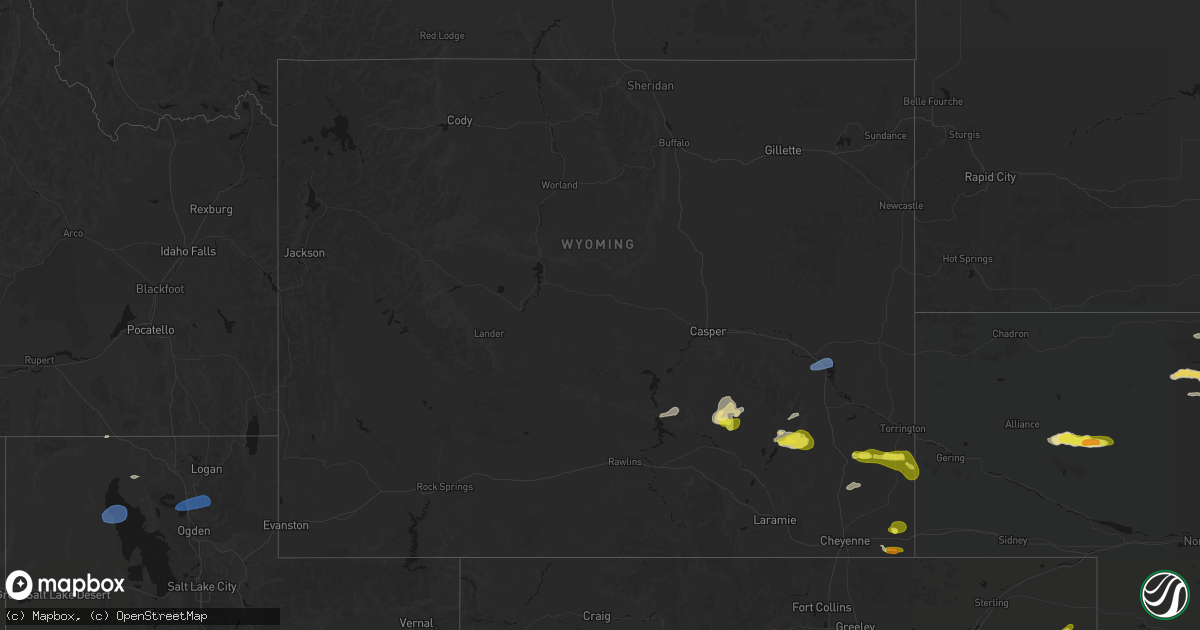
Hail Map in Wyoming on June 20, 2026
Get this storm
June 20 map
$229
one time, instant access
Download today. No call, no setup
Keep the $229
Bought the map and want the full workflow? Apply the entire $229 to a subscription within 7 days. None of it is wasted.
Every map, not just this one
This buys you this map. Subscription and you get every map we run, in the markets you choose from a few cities to whole states to nationwide. Plus real-time alerts the moment a storm fires.
Contact data
Name, contact info, occupancy, even credit band for addresses in the footprint. You go from where it hit to who to call.
Become the source they trust
Unlimited branding weather history reports on demand. You already have the documented answer ready for the property owner, and you are the one who showed up with it.
Property data and RoofTrace estimates
Pull up any address you have got, its value and the exact code rules for that jurisdiction, straight from One Click Code. Then RoofTrace estimates the squares, pitch, and roof value, priced the way you price.
Storm reports in Wyoming
Wyoming
| Date | Description |
|---|---|
| 06/20/20266:46 PM CDT | Mesonet station wy14 1.5 e sinclair |
| 06/20/20266:35 PM CDT | Asos station krwl 1 ene rawlins. |
| 06/20/20266:32 PM CDT | Mesonet station wy14 1.5 e sinclair |
| 06/20/20266:31 PM CDT | Measured on a personal weather station. |
| 06/20/20266:27 PM CDT | A local report indicates 66 MPH wind near 14 SSW Dwtn Gillette |
| 06/20/20266:22 PM CDT | Mesonet station wy14 1.5 e sinclair |
| 06/20/20266:20 PM CDT | Mesonet station pc572 platte. |
| 06/20/20266:16 PM CDT | Mesonet station wy56 i25 us26 us87 - platte converse. |
| 06/20/20266:14 PM CDT | Unofficial public personal weather station measured a 81 mph wind gust. |
| 06/20/20266:10 PM CDT | Unofficial public personal weather station measured 66 mph gust. |
| 06/20/20266:06 PM CDT | Mesonet station wy56 i25 us26 us87 - platte converse. |
| 06/20/20266:05 PM CDT | Quarter sized hail reported to have covered the ground and lasted three minutes. |
| 06/20/20266:02 PM CDT | Additional peak wind gust measured on personal weather station. |
| 06/20/20266:00 PM CDT | Purdy east pc sensor. Sustained 37 mph wind with 59 mph gust. |
| 06/20/20265:59 PM CDT | Asos station kdgw douglas airport - dgw. |
| 06/20/20265:50 PM CDT | Unofficial public personal weather station measured a 63 mph wind gust. |
| 06/20/20265:48 PM CDT | Additional wind gust measured on personal weather station. |
| 06/20/20265:48 PM CDT | Mesonet station dw7426 douglas. |
| 06/20/20265:43 PM CDT | A local report indicates 61 MPH wind near 17 SSE Wright |
| 06/20/20265:39 PM CDT | Unofficial public personal weather station gusted to 64 mph. |
| 06/20/20265:38 PM CDT | Mesonet station dw7426 douglas. |
| 06/20/20265:32 PM CDT | Public weather sensor measured gust. |
| 06/20/20265:25 PM CDT | Public weather sensor measured gust. |
| 06/20/20265:16 PM CDT | Mesonet station wy61 i-25 hat six |
| 06/20/20265:13 PM CDT | Private weather station owned by the university of wyoming gusted 68mph at 4:13pm. |
| 06/20/20265:06 PM CDT | Mesonet station ktmh i-25 twenty mile hill |
| 06/20/20265:00 PM CDT | Tisdale mountain pc sensor with 33 mph sustained and 58 mph wind gusts. |
| 06/20/20265:00 PM CDT | 64mph gust occurred at the muddy creek station just outside of converse county. It is highly likely that a similar gust was occurring in converse county... But no stati |
| 06/20/20264:56 PM CDT | Mesonet station krec wy28 red canyon |
| 06/20/20264:56 PM CDT | Mesonet station ktmh i-25 twenty mile hill |
| 06/20/20264:50 PM CDT | Mesonet station pc576 horse ranch creek |
| 06/20/20264:50 PM CDT | Mesonet station pc377 scenic dr |
| 06/20/20264:41 PM CDT | Asos station kcpr casper airport |
| 06/20/20264:40 PM CDT | Mesonet station pc457 hidden dome |
| 06/20/20264:22 PM CDT | Mesonet station wy45 us20 natrona |
| 06/20/20264:21 PM CDT | Asos station klnd lander airport |
| 06/20/20264:17 PM CDT | Mesonet station psdw4 pistol draw. |
| 06/20/20263:50 PM CDT | Mesonet station pc633 poston ranch rd |
| 06/20/20263:35 PM CDT | Awos station ktbx boysen peak |
| 06/20/20263:35 PM CDT | Awos station khsg hot springs airport |
| 06/20/20263:29 PM CDT | Asos station krwl 1 ene rawlins. |
| 06/20/20263:20 PM CDT | Mesonet station pc631 stagner |
| 06/20/20263:14 PM CDT | Asos station kriw riverton airport |
| 06/20/20263:00 PM CDT | Mesonet station sppbt surprise pinnacle |
| 06/20/20263:00 PM CDT | Mesonet station fw3816 pavillion |
| 06/20/20261:53 PM CDT | Asos station krks rock springs airport |
| 06/20/20261:20 PM CDT | Mesonet station pc258 half moon lake |
| 06/20/202612:51 PM CDT | Multiple reports... Pictures... And videos of a tall |
| 06/19/20268:54 PM CDT | Asos station krks rock springs airport |
| 06/19/20268:42 PM CDT | Mesonet station wy10 i-80 baxter rd |
| 06/19/20268:26 PM CDT | Mesonet station wy42 us191 farson |
| 06/19/20268:23 PM CDT | Mesonet station ur623 rock springs 6 wsw |
| 06/19/20268:16 PM CDT | Spotter network report of ping-ping ball sized hail 11 miles south-southeast of burns or 6 miles north-northeast of hereford... Colorado. |
| 06/19/20268:09 PM CDT | Report from mping: quarter |
| 06/19/20268:06 PM CDT | Mesonet station kshc wy372 shute creek |
| 06/19/20268:00 PM CDT | Power lines down from damaging wind. Time estimated from radar. |
| 06/19/20268:00 PM CDT | Mesonet station pc258 half moon lake |
| 06/19/20267:55 PM CDT | Small cinder block structure destroyed. Time estimated from radar. |
| 06/19/20267:55 PM CDT | Awos station kpna pinedale airport |
| 06/19/20267:53 PM CDT | Asos station kbpi big piney airport |
| 06/19/20267:51 PM CDT | Measured on a personal weather station. |
| 06/19/20267:45 PM CDT | Several trees uprooted. One large tree snapped mid-tree. Time estimated from radar. |
| 06/19/20267:40 PM CDT | Mesonet station pc452 cottonwood merna |
| 06/19/20267:16 PM CDT | Mesonet station wy30 us30 nugget canyon |
| 06/19/20267:15 PM CDT | Mesonet station mcobt mount coffin |
| 06/19/20267:12 PM CDT | Mesonet station wy16 10.5 sw hanna |
| 06/19/20267:10 PM CDT | Mesonet station pc233 elmo. |
| 06/19/20267:10 PM CDT | Mesonet station pc256 nugget canyon |
| 06/19/20267:09 PM CDT | Mesonet station up098 sage junction 3 e |
All States Impacted by Hail Map on June 20, 2026
Cities Impacted by Hail Map on June 20, 2026
- Loomis, NE
- Bertrand, NE
- Holdrege, NE
- Wilcox, NE
- Dunning, NE
- Broken Bow, NE
- Oconto, NE
- Mason City, NE
- Miller, NE
- Sumner, NE
- Anselmo, NE
- Pleasanton, NE
- Amherst, NE
- Elm Creek, NE
- Merna, NE
- Riverdale, NE
- Kearney, NE
- Callaway, NE
- Ansley, NE
- Gibbon, NE
- Shelton, NE
- Kenesaw, NE
- Wood River, NE
- Juniata, NE
- Hazard, NE
- Litchfield, NE
- Roseland, NE
- Hastings, NE
- Ayr, NE
- Glenvil, NE
- Halsey, NE
- Fairfield, NE
- Arnold, NE
- Ravenna, NE
- Stapleton, NE
- Valentine, NE
- Clay Center, NE
- Deweese, NE
- Mauk, GA
- Butler, GA
- Junction City, GA
- Edgar, NE
- Birmingham, AL
- Leeds, AL
- Brewster, NE
- Davenport, NE
- Doniphan, NE
- Thedford, NE
- Orlando, FL
- Trumbull, NE
- Venus, FL
- Elsmere, NE
- Sterrett, AL
- Vandiver, AL
- Harvard, NE
- Inland, NE
- Johnstown, NE
- Ong, NE
- Ainsworth, NE
- Saronville, NE
- Shickley, NE
- Sutton, NE
- Carleton, NE
- Marshallville, GA
- Bruning, NE
- Belvidere, NE
- Long Pine, NE
- Alexandria, NE
- Lake Placid, FL
- Montezuma, GA
- Boyers, PA
- Harrisville, PA
- Slippery Rock, PA
- Kilgore, NE
- Sebring, FL
- Crookston, NE
- Fairbury, NE
- Grand Island, NE
- Byromville, GA
- Unadilla, GA
- Lorida, FL
- Benkelman, NE
- Fort Pierce, FL
- Palisade, NE
- Wauneta, NE
- Stratton, NE
- Yuma, CO
- Purdum, NE
- Alma, GA
- Deer Trail, CO
- Eckley, CO
- Pineview, GA
- Pinehurst, GA
- Hawkinsville, GA
- Douglas, GA
- Woodrow, CO
- Wray, CO
- Max, NE
- Nicholls, GA
- Jesup, GA
- Snowville, UT
- Palm City, FL
- Hortense, GA
- Trenton, NE
- Lindon, CO
- Atwood, KS
- Hanna, WY
- Otis, CO
- Stuart, FL
- Ludell, KS
- Cheyenne, WY
- Kim, CO
- Taylor, NE
- Herndon, KS
- Lake City, FL
- Geneva, NE
- Strang, NE
- Jupiter, FL
- West Palm Beach, FL
- Haigler, NE
- Lumpkin, GA
- Laurel Hill, FL
- Sterling, MI
- Norris, SD
- Palm Beach Gardens, FL
- Genoa, CO
- Ohiowa, NE
- Culbertson, NE
- Medicine Bow, WY
- Winner, SD
- Lagrange, WY
- Burwell, NE
- Tobias, NE
- Standish, MI
- Arriba, CO
- Omer, MI
- Bennett, CO
- Holyoke, CO
- Loxahatchee, FL
- Wellington, FL
- Grouse Creek, UT
- Lamar, CO
- Sargent, NE
- Pompano Beach, FL
- Daykin, NE
- Malad City, ID
- Parks, NE
- Saint Francis, KS
- Las Animas, CO
- Plymouth, NE
- Jansen, NE
- Elyria, NE
- Preston, ID
- Lewiston, UT
- Comstock, NE
- McDonald, KS
- Diller, NE
- Western, NE
- Ochopee, FL
- Pritchett, CO
- Oberlin, KS
- Beatrice, NE
- Ord, NE
- Odell, NE
- Springfield, CO
- Blue Springs, NE
- Wymore, NE
- Bird City, KS
- Garrett, WY
- Arcadia, NE
- Colby, KS
- Edson, KS
- Loup City, NE
- Tremonton, UT
- Levant, KS
- Selden, KS
- Bosler, WY
- Scotia, NE
- North Loup, NE
- Glendo, WY
- Fort Morgan, CO
- Brewster, KS
- Lowell, OH
- Wheatland, WY
- Beverly, OH
- Harrold, SD
- Guernsey, WY
- Fort Pierre, SD
- Jay Em, WY
- Okaton, SD
- Belvidere, SD
- Kyle, SD
- Interior, SD
- Onida, SD
- Whitney, NE
- Oelrichs, SD
- Torrington, WY
- Hartville, WY
- Pine Ridge, SD
- Kadoka, SD
- Pierre, SD
- Crawford, NE
- Fort Laramie, WY
- Midland, SD
- Wanblee, SD
- Harrison, NE
- Blunt, SD
- Chadron, NE
- Willard, UT
- Brigham City, UT
- Eden, UT
- Logan, UT
- Mantua, UT
- Huntsville, UT
- Ashton, NE
- Greeley, NE
- Rexford, KS
- Coal Run, OH
- Waterford, OH
- Gem, KS
- Hoxie, KS
- Rockville, NE
- Elba, NE
- Farwell, NE
- Saint Paul, NE
- Boelus, NE
- Wolbach, NE
- Oakley, KS
- Burlington, CO
- Goodland, KS
- Liberty, NE
- Burchard, NE
- Wallace, KS
- Winona, KS
- Dannebrog, NE
- Cairo, NE
- Palmer, NE
- Kit Carson, CO
- Stratton, CO
- Bethune, CO
- Cheyenne Wells, CO
- Monument, KS
- Lakeside, NE
- Ellsworth, NE
- Saint Libory, NE
- Kanorado, KS
- Arapahoe, CO
- Oshkosh, NE
- Baileyville, KS
- Axtell, KS
- Two Buttes, CO
- Walsh, CO
- Granada, CO
- Alda, NE
- Yoder, WY
- Bingham, NE
- Grinnell, KS
- Weskan, KS
- Chugwater, WY
- Hawk Springs, WY
- Ashby, NE
- Burns, WY
- Pine Bluffs, WY
- Lenora, KS
- Grainfield, KS
- Park, KS
- Gove, KS
- Sharon Springs, KS
- Lyman, NE
- Harrisburg, NE
- Carpenter, WY
- Giltner, NE
- Blue Hill, NE
- Quinter, KS
- Collyer, KS
- Scott City, KS
- Leoti, KS
- Lawrence, NE
- Grover, CO
- Wakeeney, KS
- Nelson, NE
- New Raymer, CO
- Dighton, KS
- Healy, KS
- Indianola, NE
- McCook, NE
- Oak, NE
- Marienthal, KS
- Utica, KS
- Otter, MT
- Ogallah, KS
- Arnold, KS
- Brownell, KS
- Garden City, KS
- Ness City, KS
- Deerfield, KS
- Ransom, KS
- Beeler, KS
- Holcomb, KS
- Cimarron, KS
- Ellis, KS
- Bayard, NE
- Bridgeport, NE
- Deshler, NE
- Ruskin, NE
- Hebron, NE
- Byron, NE
- Hardy, NE
- Broadwater, NE
- Lisco, NE
- Jetmore, KS
- Munden, KS
- Belleville, KS
- Agenda, KS
- Narka, KS
- Republic, KS
- Hubbell, NE
- Chester, NE
- Cuba, KS
- Hanston, KS
- Bazine, KS
- Alexander, KS
- Hays, KS
- McCracken, KS
- Seneca, KS
- Oneida, KS
- Bern, KS
- Sabetha, KS
- Burdett, KS
- Nekoma, KS
- Sterling, CO
- Stoneham, CO
- Merino, CO
- Haddam, KS
- Clifton, KS
- Clyde, KS
- Morrowville, KS
- Kinsley, KS
- Wright, KS
- Offerle, KS
- Dodge City, KS
- Pierceville, KS
- Ingalls, KS
- Spearville, KS
- La Crosse, KS
- Lewis, KS
- Schoenchen, KS
- Garfield, KS
- Liebenthal, KS
- Rozel, KS
- Larned, KS
- Rush Center, KS
- Pfeifer, KS
- Bison, KS
- Otis, KS
- Victoria, KS
- Fairview, KS
- Morrill, KS
- Hiawatha, KS
- Powhattan, KS
- Tryon, NE
- Belpre, KS
- Ensign, KS
- Great Bend, KS
- Olmitz, KS
- Albert, KS
- Hoisington, KS
- Macksville, KS
- Pawnee Rock, KS
- Russell, KS
- Gorham, KS
- Walker, KS
- Cody, NE
- Bucklin, KS
- Byers, KS
- St John, KS
- Ford, KS
- Haviland, KS
- Greensburg, KS
- Stafford, KS
- Iuka, KS
- Hudson, KS
- Ellinwood, KS
- Bunker Hill, KS
- Claflin, KS
- Dorrance, KS
- Lucerne, CO
- Greeley, CO
- Robinson, KS
- Lewellen, NE
- Gill, CO
- Kersey, CO
- Minneola, KS
- Pratt, KS
- Eaton, CO
- Highland, KS
- Lemoyne, NE
- Turon, KS
- Mullinville, KS
- Coats, KS
- Cunningham, KS
- Plevna, KS
- Chase, KS
- Sylvia, KS
- Raymond, KS
- Holyrood, KS
- Ellsworth, KS
- Wilson, KS
- Bushton, KS
- Sterling, KS
- Lorraine, KS
- Alden, KS
- Lyons, KS
- Abbyville, KS
- Arlington, KS
- Geneseo, KS
- Sun City, KS
- Roggen, CO
- Sawyer, KS
- Jennings, KS
- Dresden, KS
- Isabel, KS
- Protection, KS
- Medicine Lodge, KS
- Kingman, KS
- Murdock, KS
- Cheney, KS
- Coldwater, KS
- Wilmore, KS
- Nashville, KS
- Hutchinson, KS
- Nickerson, KS
- Partridge, KS
- Pretty Prairie, KS
- Inman, KS
- Marquette, KS
- South Hutchinson, KS
- Little River, KS
- Fowler, KS
- Zenda, KS
- Spivey, KS
- Lake City, KS
- Harper, KS
- Attica, KS
- Sharon, KS
- Andale, KS
- Argonia, KS
- Halstead, KS
- Conway Springs, KS
- Goddard, KS
- Buhler, KS
- Haven, KS
- Wichita, KS
- Mcpherson, KS
- Windom, KS
- Valley Center, KS
- Sedgwick, KS
- Maize, KS
- Colwich, KS
- Norwich, KS
- Bentley, KS
- Clearwater, KS
- Garden Plain, KS
- Mount Hope, KS
- Danville, KS
- Burrton, KS
- Milton, KS
- Viola, KS
- Moundridge, KS
- Caldwell, KS
- Mayfield, KS
- Haysville, KS
- Freeport, KS
- Milan, KS
- Mulvane, KS
- Rose Hill, KS
- Wellington, KS
- Augusta, KS
- Towanda, KS
- Greenwich, KS
- Belle Plaine, KS
- Newton, KS
- Peck, KS
- Douglass, KS
- Derby, KS
- Hesston, KS
- Andover, KS
- Mcconnell Afb, KS
- Benton, KS
- Kechi, KS
- Hillsboro, KS
- Whitewater, KS
- Potwin, KS
- Walton, KS
- North Newton, KS
- Elbing, KS
- Peabody, KS
- Canton, KS
- Goessel, KS
- El Dorado, KS
- Galva, KS
- Lehigh, KS
- Winfield, KS
- Oxford, KS
- Udall, KS
- Rock, KS
- Atlanta, KS
- Leon, KS
- Latham, KS
- Rosalia, KS
- Burns, KS
- Florence, KS
- Marion, KS
- Cassoday, KS
- Burden, KS
- Anthony, KS
- Bluff City, KS
- South Haven, KS
- Dexter, KS
- Cambridge, KS
- Geuda Springs, KS


