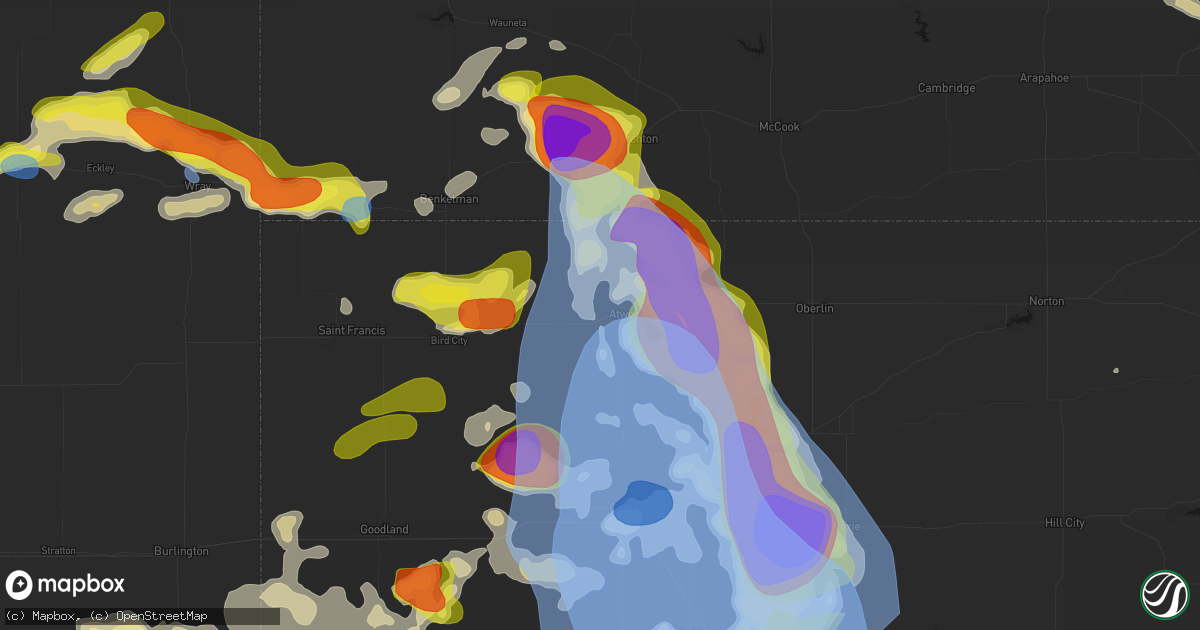
Hail Map in Atwood, KS on June 20, 2026
Get this storm
June 20 map
$229
one time, instant access
Download today. No call, no setup
Keep the $229
Bought the map and want the full workflow? Apply the entire $229 to a subscription within 7 days. None of it is wasted.
Every map, not just this one
This buys you this map. Subscription and you get every map we run, in the markets you choose from a few cities to whole states to nationwide. Plus real-time alerts the moment a storm fires.
Contact data
Name, contact info, occupancy, even credit band for addresses in the footprint. You go from where it hit to who to call.
Become the source they trust
Unlimited branding weather history reports on demand. You already have the documented answer ready for the property owner, and you are the one who showed up with it.
Property data and RoofTrace estimates
Pull up any address you have got, its value and the exact code rules for that jurisdiction, straight from One Click Code. Then RoofTrace estimates the squares, pitch, and roof value, priced the way you price.
Storm reports in Atwood, KS
Atwood, KS
| Date | Description |
|---|---|
| 06/20/20266:22 PM CDT | From mping: active tornado on the ground to the south of achilles... Kansas it just hit my car and got thrown over 10 yards off the road and theres lots of debris and d |
| 06/20/20265:43 PM CDT | Public report via phone with various hail sizes with golf balls as the biggest. |
| 06/20/20265:38 PM CDT | Chaser saw brief tornado east of highway 25. Lifted during report. |
| 06/20/20265:32 PM CDT | Tornado briefly spotted by storm chaser. Location estimated by radar. |
| 06/20/20265:29 PM CDT | Nssl measured 89 mph wind gust 3 miles south of atwood. |
| 06/20/20265:19 PM CDT | Tds observed on radar. |
| 06/20/20265:10 PM CDT | Social media report of a photo of a tornado via x. |
| 06/20/20265:07 PM CDT | Multiple reports from chasers of a tornado crossing highway 36 near atwood. |
| 06/20/20265:06 PM CDT | Multiple chaser reports and video on livestream of power poles being knocked down. |
| 06/20/20264:17 PM CDT | Report from mping: ping pong ball |
All States Impacted by Hail Map on June 20, 2026
All Cities Impacted by Hail Map on June 20, 2026
- Loomis, NE
- Bertrand, NE
- Holdrege, NE
- Wilcox, NE
- Dunning, NE
- Broken Bow, NE
- Oconto, NE
- Mason City, NE
- Miller, NE
- Sumner, NE
- Anselmo, NE
- Pleasanton, NE
- Amherst, NE
- Elm Creek, NE
- Merna, NE
- Riverdale, NE
- Kearney, NE
- Callaway, NE
- Ansley, NE
- Gibbon, NE
- Shelton, NE
- Kenesaw, NE
- Wood River, NE
- Juniata, NE
- Hazard, NE
- Litchfield, NE
- Roseland, NE
- Hastings, NE
- Ayr, NE
- Glenvil, NE
- Halsey, NE
- Fairfield, NE
- Arnold, NE
- Ravenna, NE
- Stapleton, NE
- Valentine, NE
- Clay Center, NE
- Deweese, NE
- Mauk, GA
- Butler, GA
- Junction City, GA
- Edgar, NE
- Birmingham, AL
- Leeds, AL
- Brewster, NE
- Davenport, NE
- Doniphan, NE
- Thedford, NE
- Orlando, FL
- Trumbull, NE
- Venus, FL
- Elsmere, NE
- Sterrett, AL
- Vandiver, AL
- Harvard, NE
- Inland, NE
- Johnstown, NE
- Ong, NE
- Ainsworth, NE
- Saronville, NE
- Shickley, NE
- Sutton, NE
- Carleton, NE
- Marshallville, GA
- Bruning, NE
- Belvidere, NE
- Long Pine, NE
- Alexandria, NE
- Lake Placid, FL
- Montezuma, GA
- Boyers, PA
- Harrisville, PA
- Slippery Rock, PA
- Kilgore, NE
- Sebring, FL
- Crookston, NE
- Fairbury, NE
- Grand Island, NE
- Byromville, GA
- Unadilla, GA
- Lorida, FL
- Benkelman, NE
- Fort Pierce, FL
- Palisade, NE
- Wauneta, NE
- Stratton, NE
- Yuma, CO
- Purdum, NE
- Alma, GA
- Deer Trail, CO
- Eckley, CO
- Pineview, GA
- Pinehurst, GA
- Hawkinsville, GA
- Douglas, GA
- Woodrow, CO
- Wray, CO
- Max, NE
- Nicholls, GA
- Jesup, GA
- Snowville, UT
- Palm City, FL
- Hortense, GA
- Trenton, NE
- Lindon, CO
- Atwood, KS
- Hanna, WY
- Otis, CO
- Stuart, FL
- Ludell, KS
- Cheyenne, WY
- Kim, CO
- Taylor, NE
- Herndon, KS
- Lake City, FL
- Geneva, NE
- Strang, NE
- Jupiter, FL
- West Palm Beach, FL
- Haigler, NE
- Lumpkin, GA
- Laurel Hill, FL
- Sterling, MI
- Norris, SD
- Palm Beach Gardens, FL
- Genoa, CO
- Ohiowa, NE
- Culbertson, NE
- Medicine Bow, WY
- Winner, SD
- Lagrange, WY
- Burwell, NE
- Tobias, NE
- Standish, MI
- Arriba, CO
- Omer, MI
- Bennett, CO
- Holyoke, CO
- Loxahatchee, FL
- Wellington, FL
- Grouse Creek, UT
- Lamar, CO
- Sargent, NE
- Pompano Beach, FL
- Daykin, NE
- Malad City, ID
- Parks, NE
- Saint Francis, KS
- Las Animas, CO
- Plymouth, NE
- Jansen, NE
- Elyria, NE
- Preston, ID
- Lewiston, UT
- Comstock, NE
- McDonald, KS
- Diller, NE
- Western, NE
- Ochopee, FL
- Pritchett, CO
- Oberlin, KS
- Beatrice, NE
- Ord, NE
- Odell, NE
- Springfield, CO
- Blue Springs, NE
- Wymore, NE
- Bird City, KS
- Garrett, WY
- Arcadia, NE
- Colby, KS
- Edson, KS
- Loup City, NE
- Tremonton, UT
- Levant, KS
- Selden, KS
- Bosler, WY
- Scotia, NE
- North Loup, NE
- Glendo, WY
- Fort Morgan, CO
- Brewster, KS
- Lowell, OH
- Wheatland, WY
- Beverly, OH
- Harrold, SD
- Guernsey, WY
- Fort Pierre, SD
- Jay Em, WY
- Okaton, SD
- Belvidere, SD
- Kyle, SD
- Interior, SD
- Onida, SD
- Whitney, NE
- Oelrichs, SD
- Torrington, WY
- Hartville, WY
- Pine Ridge, SD
- Kadoka, SD
- Pierre, SD
- Crawford, NE
- Fort Laramie, WY
- Midland, SD
- Wanblee, SD
- Harrison, NE
- Blunt, SD
- Chadron, NE
- Willard, UT
- Brigham City, UT
- Eden, UT
- Logan, UT
- Mantua, UT
- Huntsville, UT
- Ashton, NE
- Greeley, NE
- Rexford, KS
- Coal Run, OH
- Waterford, OH
- Gem, KS
- Hoxie, KS
- Rockville, NE
- Elba, NE
- Farwell, NE
- Saint Paul, NE
- Boelus, NE
- Wolbach, NE
- Oakley, KS
- Burlington, CO
- Goodland, KS
- Liberty, NE
- Burchard, NE
- Wallace, KS
- Winona, KS
- Dannebrog, NE
- Cairo, NE
- Palmer, NE
- Kit Carson, CO
- Stratton, CO
- Bethune, CO
- Cheyenne Wells, CO
- Monument, KS
- Lakeside, NE
- Ellsworth, NE
- Saint Libory, NE
- Kanorado, KS
- Arapahoe, CO
- Oshkosh, NE
- Baileyville, KS
- Axtell, KS
- Two Buttes, CO
- Walsh, CO
- Granada, CO
- Alda, NE
- Yoder, WY
- Bingham, NE
- Grinnell, KS
- Weskan, KS
- Chugwater, WY
- Hawk Springs, WY
- Ashby, NE
- Burns, WY
- Pine Bluffs, WY
- Lenora, KS
- Grainfield, KS
- Park, KS
- Gove, KS
- Sharon Springs, KS
- Lyman, NE
- Harrisburg, NE
- Carpenter, WY
- Giltner, NE
- Blue Hill, NE
- Quinter, KS
- Collyer, KS
- Scott City, KS
- Leoti, KS
- Lawrence, NE
- Grover, CO
- Wakeeney, KS
- Nelson, NE
- New Raymer, CO
- Dighton, KS
- Healy, KS
- Indianola, NE
- McCook, NE
- Oak, NE
- Marienthal, KS
- Utica, KS
- Otter, MT
- Ogallah, KS
- Arnold, KS
- Brownell, KS
- Garden City, KS
- Ness City, KS
- Deerfield, KS
- Ransom, KS
- Beeler, KS
- Holcomb, KS
- Cimarron, KS
- Ellis, KS
- Bayard, NE
- Bridgeport, NE
- Deshler, NE
- Ruskin, NE
- Hebron, NE
- Byron, NE
- Hardy, NE
- Broadwater, NE
- Lisco, NE
- Jetmore, KS
- Munden, KS
- Belleville, KS
- Agenda, KS
- Narka, KS
- Republic, KS
- Hubbell, NE
- Chester, NE
- Cuba, KS
- Hanston, KS
- Bazine, KS
- Alexander, KS
- Hays, KS
- McCracken, KS
- Seneca, KS
- Oneida, KS
- Bern, KS
- Sabetha, KS
- Burdett, KS
- Nekoma, KS
- Sterling, CO
- Stoneham, CO
- Merino, CO
- Haddam, KS
- Clifton, KS
- Clyde, KS
- Morrowville, KS
- Kinsley, KS
- Wright, KS
- Offerle, KS
- Dodge City, KS
- Pierceville, KS
- Ingalls, KS
- Spearville, KS
- La Crosse, KS
- Lewis, KS
- Schoenchen, KS
- Garfield, KS
- Liebenthal, KS
- Rozel, KS
- Larned, KS
- Rush Center, KS
- Pfeifer, KS
- Bison, KS
- Otis, KS
- Victoria, KS
- Fairview, KS
- Morrill, KS
- Hiawatha, KS
- Powhattan, KS
- Tryon, NE
- Belpre, KS
- Ensign, KS
- Great Bend, KS
- Olmitz, KS
- Albert, KS
- Hoisington, KS
- Macksville, KS
- Pawnee Rock, KS
- Russell, KS
- Gorham, KS
- Walker, KS
- Cody, NE
- Bucklin, KS
- Byers, KS
- St John, KS
- Ford, KS
- Haviland, KS
- Greensburg, KS
- Stafford, KS
- Iuka, KS
- Hudson, KS
- Ellinwood, KS
- Bunker Hill, KS
- Claflin, KS
- Dorrance, KS
- Lucerne, CO
- Greeley, CO
- Robinson, KS
- Lewellen, NE
- Gill, CO
- Kersey, CO
- Minneola, KS
- Pratt, KS
- Eaton, CO
- Highland, KS
- Lemoyne, NE
- Turon, KS
- Mullinville, KS
- Coats, KS
- Cunningham, KS
- Plevna, KS
- Chase, KS
- Sylvia, KS
- Raymond, KS
- Holyrood, KS
- Ellsworth, KS
- Wilson, KS
- Bushton, KS
- Sterling, KS
- Lorraine, KS
- Alden, KS
- Lyons, KS
- Abbyville, KS
- Arlington, KS
- Geneseo, KS
- Sun City, KS
- Roggen, CO
- Sawyer, KS
- Jennings, KS
- Dresden, KS
- Isabel, KS
- Protection, KS
- Medicine Lodge, KS
- Kingman, KS
- Murdock, KS
- Cheney, KS
- Coldwater, KS
- Wilmore, KS
- Nashville, KS
- Hutchinson, KS
- Nickerson, KS
- Partridge, KS
- Pretty Prairie, KS
- Inman, KS
- Marquette, KS
- South Hutchinson, KS
- Little River, KS
- Fowler, KS
- Zenda, KS
- Spivey, KS
- Lake City, KS
- Harper, KS
- Attica, KS
- Sharon, KS
- Andale, KS
- Argonia, KS
- Halstead, KS
- Conway Springs, KS
- Goddard, KS
- Buhler, KS
- Haven, KS
- Wichita, KS
- Mcpherson, KS
- Windom, KS
- Valley Center, KS
- Sedgwick, KS
- Maize, KS
- Colwich, KS
- Norwich, KS
- Bentley, KS
- Clearwater, KS
- Garden Plain, KS
- Mount Hope, KS
- Danville, KS
- Burrton, KS
- Milton, KS
- Viola, KS
- Moundridge, KS
- Caldwell, KS
- Mayfield, KS
- Haysville, KS
- Freeport, KS
- Milan, KS
- Mulvane, KS
- Rose Hill, KS
- Wellington, KS
- Augusta, KS
- Towanda, KS
- Greenwich, KS
- Belle Plaine, KS
- Newton, KS
- Peck, KS
- Douglass, KS
- Derby, KS
- Hesston, KS
- Andover, KS
- Mcconnell Afb, KS
- Benton, KS
- Kechi, KS
- Hillsboro, KS
- Whitewater, KS
- Potwin, KS
- Walton, KS
- North Newton, KS
- Elbing, KS
- Peabody, KS
- Canton, KS
- Goessel, KS
- El Dorado, KS
- Galva, KS
- Lehigh, KS
- Winfield, KS
- Oxford, KS
- Udall, KS
- Rock, KS
- Atlanta, KS
- Leon, KS
- Latham, KS
- Rosalia, KS
- Burns, KS
- Florence, KS
- Marion, KS
- Cassoday, KS
- Burden, KS
- Anthony, KS
- Bluff City, KS
- South Haven, KS
- Dexter, KS
- Cambridge, KS
- Geuda Springs, KS


