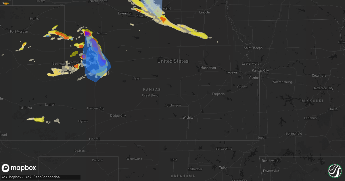
Hail Map in Kansas on June 20, 2026
Get this storm
June 20 map
$229
one time, instant access
Download today. No call, no setup
Keep the $229
Bought the map and want the full workflow? Apply the entire $229 to a subscription within 7 days. None of it is wasted.
Every map, not just this one
This buys you this map. Subscription and you get every map we run, in the markets you choose from a few cities to whole states to nationwide. Plus real-time alerts the moment a storm fires.
Contact data
Name, contact info, occupancy, even credit band for addresses in the footprint. You go from where it hit to who to call.
Become the source they trust
Unlimited branding weather history reports on demand. You already have the documented answer ready for the property owner, and you are the one who showed up with it.
Property data and RoofTrace estimates
Pull up any address you have got, its value and the exact code rules for that jurisdiction, straight from One Click Code. Then RoofTrace estimates the squares, pitch, and roof value, priced the way you price.
Storm reports in Kansas
Kansas
| Date | Description |
|---|---|
| 06/20/20266:55 PM CDT | Delayed report of up to 8 inch live tree branches blown down in oakley. Roll-over accidents also occurred in the area... Including a tractor-trailer roll-over at mm75 o |
| 06/20/20266:52 PM CDT | Social media |
| 06/20/20266:50 PM CDT | Mesonet station fw6347 colby 2e. |
| 06/20/20266:49 PM CDT | Spotter network report of overturned semis. |
| 06/20/20266:47 PM CDT | Mesonet station up840 9.0 w winona |
| 06/20/20266:46 PM CDT | Mesonet station fw8773 colby. |
| 06/20/20266:46 PM CDT | From mping: brief tornado touched the ground for at least a minute then lifted just west of selden kansas and north of rexford kansas. |
| 06/20/20266:45 PM CDT | Davis; rietcheck farms. |
| 06/20/20266:45 PM CDT | Spotter network of multiple trees down across roadways. |
| 06/20/20266:45 PM CDT | Report from mping: tennis ball |
| 06/20/20266:45 PM CDT | Report from mping: tennis ball |
| 06/20/20266:41 PM CDT | Awn; ambient_d9d4ce285316fd14bdfc93c7339dde25. |
| 06/20/20266:40 PM CDT | Multiple spotter network reports of trees down in colby. |
| 06/20/20266:35 PM CDT | Nssl measurement of 91 mph wind gust. |
| 06/20/20266:34 PM CDT | Weather station kkscolby59 measured 100 mph wind gusts from 6:34 to 6:44 pm cdt. Multiple trees are down. |
| 06/20/20266:31 PM CDT | Weather underground; wwtp vantagepro - kkscolby59. |
| 06/20/20266:30 PM CDT | Weatherlink site 5.8 n seguin reports 65 mph. |
| 06/20/20266:22 PM CDT | From mping: active tornado on the ground to the south of achilles... Kansas it just hit my car and got thrown over 10 yards off the road and theres lots of debris and d |
| 06/20/20266:16 PM CDT | Spotter network report. |
| 06/20/20266:16 PM CDT | Measured 60 mph winds in the inflow. |
| 06/20/20266:04 PM CDT | Storm chaser measured 60 mph wind gust. |
| 06/20/20266:00 PM CDT | Ambient station in rexford measured 58 mph gust. |
| 06/20/20265:53 PM CDT | Measured 61 mph gust from spotter network. |
| 06/20/20265:50 PM CDT | Awn; ambient_44b7143c575b2968cdf184967408ca28. |
| 06/20/20265:47 PM CDT | Awn; ambient_feec3c7ca876bd69b672d9909c4622a2. |
| 06/20/20265:43 PM CDT | Public report via phone with various hail sizes with golf balls as the biggest. |
| 06/20/20265:38 PM CDT | Chaser saw brief tornado east of highway 25. Lifted during report. |
| 06/20/20265:32 PM CDT | Tornado briefly spotted by storm chaser. Location estimated by radar. |
| 06/20/20265:29 PM CDT | Nssl measured 89 mph wind gust 3 miles south of atwood. |
| 06/20/20265:19 PM CDT | Awn; ambient_44b7143c575b2968cdf184967408ca28. |
| 06/20/20265:19 PM CDT | Tds observed on radar. |
| 06/20/20265:10 PM CDT | Social media report of a photo of a tornado via x. |
| 06/20/20265:07 PM CDT | Multiple reports from chasers of a tornado crossing highway 36 near atwood. |
| 06/20/20265:06 PM CDT | Multiple chaser reports and video on livestream of power poles being knocked down. |
| 06/20/20264:50 PM CDT | Trained spotter reports golf ball sized hail. |
| 06/20/20264:17 PM CDT | Report from mping: ping pong ball |
| 06/20/202611:48 AM CDT | Delayed report from social media of a semi flipped on i-70 near russell. Time estimated from radar. |
| 06/20/20261:21 AM CDT | A local report indicates 58 MPH wind near 1 SSW Derby |
| 06/20/20261:18 AM CDT | Radar confirmed tornado. |
| 06/20/20261:14 AM CDT | A local report indicates 68 MPH wind near 1 NNW Moundridge |
| 06/20/20261:13 AM CDT | 70 mph winds along with a few tree branches down. |
| 06/20/20261:11 AM CDT | Social media pictures show damage to a roof of a home east of kechi. Precise location unknown and time estimated from radar. |
| 06/20/20261:10 AM CDT | Public reported that their secured grill was blown into their dining room window shattering the window. |
| 06/20/202612:58 AM CDT | Public reported a large wooden swing set and fence damaged as well as some tree limbs of unknown size down. Delayed report... Time estimated from radar. |
| 06/20/202612:58 AM CDT | Delayed report. Observed several large... Healthy tree limbs |
| 06/20/202612:58 AM CDT | Est gusts 65 to 70 mph. |
| 06/20/202612:46 AM CDT | A local report indicates 65 MPH wind near 2 NNW Andale |
| 06/20/202612:40 AM CDT | Delayed report. Quarter-size hail with picture via social media. |
| 06/20/202612:36 AM CDT | Est. 50 to 60 mph winds. Report from social media. Time estimated from radar. |
| 06/20/202612:20 AM CDT | A local report indicates 60 MPH wind near 1 NW Kingman |
| 06/20/202612:19 AM CDT | A local report indicates 61 MPH wind near 3.8 SSE Ellinwood |
| 06/19/202611:55 PM CDT | Report received through social media. |
| 06/19/202611:44 PM CDT | Awos station kgbd great bend municipal airpt. |
| 06/19/202611:39 PM CDT | Report was from upr weather station. |
| 06/19/202611:32 PM CDT | Report was from an awn weather station. |
| 06/19/202611:32 PM CDT | Report was from a personal weather station. |
| 06/19/202611:30 PM CDT | A local report indicates 1.00 inch wind near 1 N Dodge City |
| 06/19/202611:28 PM CDT | Wind gust report was from an awn weather station. |
| 06/19/202611:28 PM CDT | Report was from a personal weather station. |
| 06/19/202611:24 PM CDT | Report received through social media with pictures. |
| 06/19/202611:23 PM CDT | Report was from a personal weather station. |
| 06/19/202611:17 PM CDT | Report was from a awn weather station. |
| 06/19/202611:17 PM CDT | Report was from a personal weather station. |
| 06/19/202611:15 PM CDT | Report was from klqr awos. |
| 06/19/202611:07 PM CDT | Asos station krsl russell municipal airport. |
| 06/19/202611:05 PM CDT | Delayed report -- semi truck blown over on us hwy 156 east of great bend. Time estimated from radar. From great bend post digital news article. |
| 06/19/202611:05 PM CDT | Mesonet station knuk1 kinsley 6s. |
| 06/19/202611:05 PM CDT | Delayed report... Time estimated from radar and surrounding reports. About six 12-15 inch diameter trees uprooted across town... And several 6-8 inch diameter tree limb |
| 06/19/202611:00 PM CDT | A local report indicates 1.00 inch wind near 1 SE Ingalls |
| 06/19/202611:00 PM CDT | Asos station krsl russell municipal airport. |
| 06/19/202610:52 PM CDT | Asos station kddc dodge city regional airport. |
| 06/19/202610:48 PM CDT | Corrects previous tstm wnd dmg report from 2 ssw russell. Delayed report from social media of a semi flipped on i-70 near russell. Time estimated from radar. |
| 06/19/202610:39 PM CDT | Delayed report. Social media report with pictures of shed roof damage and large healthy tree with multiple large branches snapped near this location. |
| 06/19/202610:38 PM CDT | Report was from a awn weather station. |
| 06/19/202610:38 PM CDT | Wind gust report was from a awn weather station. |
| 06/19/202610:35 PM CDT | Awos station khys hays regional airport awos site. |
| 06/19/202610:33 PM CDT | Mesonet station up853 walker |
| 06/19/202610:29 PM CDT | Hail was measured approximately 20 minutes after it fell. Time of event based on radar data. |
| 06/19/202610:26 PM CDT | Asos station kgck garden city. |
| 06/19/202610:25 PM CDT | Report was from a personal davis weatherlink station. |
| 06/19/202610:22 PM CDT | Wind gust report from a personal weather station. |
| 06/19/202610:21 PM CDT | Wind gust report was from a awn weather station. |
| 06/19/202610:19 PM CDT | The wind gust was measured by a hand held anemometer. A road sign was blown over at this location. |
| 06/19/202610:15 PM CDT | Wind gust report was from the personal davis weatherlink. |
| 06/19/202610:11 PM CDT | The gust was measured with a hand held anemometer. |
| 06/19/202610:10 PM CDT | The spotter estimated 60 to 70 mph wind gusts on the east side of jetmore. |
| 06/19/20269:46 PM CDT | Wind gust report was from a personal weather station. |
| 06/19/20269:45 PM CDT | Wind gust report was from a personal weather station. |
| 06/19/20269:28 PM CDT | A local report indicates 1.75 inch wind near Dighton |
| 06/19/20269:25 PM CDT | Mesonet station ks010 us-50 @ k-156 bridge garden city. |
| 06/19/20269:25 PM CDT | Wind gust report was from a personal davis weatherlink station. |
| 06/19/20269:15 PM CDT | Awos station ktqk scott city. |
| 06/19/20269:15 PM CDT | Report was received from a personal davis weatherlink station. |
| 06/19/20269:09 PM CDT | A local report indicates 59 MPH wind near 4 SSE Plainville |
| 06/19/20269:03 PM CDT | Weather underground; lm weather - kksmarie11. |
| 06/19/20269:00 PM CDT | Wind gusts of 70 to 75 mph were reported. |
| 06/19/20268:57 PM CDT | Report was from a awn weather station. |
| 06/19/20268:55 PM CDT | Awos station koel 2 ese oakley. |
| 06/19/20268:41 PM CDT | Davis; cobalt cattle: leoti. |
| 06/19/20268:31 PM CDT | A local report indicates 58 MPH wind near 4 NNE Webster State Par |
| 06/19/20268:30 PM CDT | Weatherlink site 10 n selkirk measured 59 mph gust. |
| 06/19/20268:25 PM CDT | Weatherlink site 12.9 n selkirk measured 61 mph gust. |
| 06/19/20268:25 PM CDT | Weather underground; aero b ranch - kkswalla4. |
| 06/19/20268:14 PM CDT | Mesonet station up840 9.0 w winona |
| 06/19/20268:01 PM CDT | Nickel to quarter size hail in town. |
| 06/19/20268:00 PM CDT | Mesonet station up846 2.0 e quinter |
| 06/19/20268:00 PM CDT | Weatherlink site in quinter reports 60 mph gust. |
| 06/19/20267:54 PM CDT | Weatherlink site 6.4 nnw gove measured 66 mph gust. |
| 06/19/20267:48 PM CDT | Asos station kgld goodland. |
| 06/19/20267:44 PM CDT | Mping: personal weather station kkscolby59 is currently mesuring 70 mph still. |
| 06/19/20267:42 PM CDT | Spotter network report of quarter sized hail. |
| 06/19/20267:34 PM CDT | Mesonet station up830 3.3 e grinnell |
| 06/19/20267:33 PM CDT | Social media report of estimated 70-80 mph winds. |
| 06/19/20267:33 PM CDT | Asos station kgld goodland. |
| 06/19/20267:29 PM CDT | Mesonet station up830 3.3 e grinnell |
| 06/19/20267:29 PM CDT | Mesonet station up840 9.0 w winona |
| 06/19/20267:28 PM CDT | Awn; section 17 mcallaster. |
| 06/19/20267:24 PM CDT | Up840. |
| 06/19/20267:22 PM CDT | Trained spotter estimates 70-80 mph gust. |
| 06/19/20267:22 PM CDT | Trained spotter estimates 2 inch hailstones. |
| 06/19/20267:09 PM CDT | Spotter network report of 65-70 mph inflow winds. |
| 06/19/20267:04 PM CDT | Report via text line. |
| 06/19/20267:03 PM CDT | Social media report: video of a tornado touching down. |
| 06/19/20267:03 PM CDT | Healthy tree had side branch split off at base. |
| 06/19/20267:02 PM CDT | Awn; summers646. |
| 06/19/20267:00 PM CDT | Report from mping: baseball |
All States Impacted by Hail Map on June 20, 2026
Cities Impacted by Hail Map on June 20, 2026
- Loomis, NE
- Bertrand, NE
- Holdrege, NE
- Wilcox, NE
- Dunning, NE
- Broken Bow, NE
- Oconto, NE
- Mason City, NE
- Miller, NE
- Sumner, NE
- Anselmo, NE
- Pleasanton, NE
- Amherst, NE
- Elm Creek, NE
- Merna, NE
- Riverdale, NE
- Kearney, NE
- Callaway, NE
- Ansley, NE
- Gibbon, NE
- Shelton, NE
- Kenesaw, NE
- Wood River, NE
- Juniata, NE
- Hazard, NE
- Litchfield, NE
- Roseland, NE
- Hastings, NE
- Ayr, NE
- Glenvil, NE
- Halsey, NE
- Fairfield, NE
- Arnold, NE
- Ravenna, NE
- Stapleton, NE
- Valentine, NE
- Clay Center, NE
- Deweese, NE
- Mauk, GA
- Butler, GA
- Junction City, GA
- Edgar, NE
- Birmingham, AL
- Leeds, AL
- Brewster, NE
- Davenport, NE
- Doniphan, NE
- Thedford, NE
- Orlando, FL
- Trumbull, NE
- Venus, FL
- Elsmere, NE
- Sterrett, AL
- Vandiver, AL
- Harvard, NE
- Inland, NE
- Johnstown, NE
- Ong, NE
- Ainsworth, NE
- Saronville, NE
- Shickley, NE
- Sutton, NE
- Carleton, NE
- Marshallville, GA
- Bruning, NE
- Belvidere, NE
- Long Pine, NE
- Alexandria, NE
- Lake Placid, FL
- Montezuma, GA
- Boyers, PA
- Harrisville, PA
- Slippery Rock, PA
- Kilgore, NE
- Sebring, FL
- Crookston, NE
- Fairbury, NE
- Grand Island, NE
- Byromville, GA
- Unadilla, GA
- Lorida, FL
- Benkelman, NE
- Fort Pierce, FL
- Palisade, NE
- Wauneta, NE
- Stratton, NE
- Yuma, CO
- Purdum, NE
- Alma, GA
- Deer Trail, CO
- Eckley, CO
- Pineview, GA
- Pinehurst, GA
- Hawkinsville, GA
- Douglas, GA
- Woodrow, CO
- Wray, CO
- Max, NE
- Nicholls, GA
- Jesup, GA
- Snowville, UT
- Palm City, FL
- Hortense, GA
- Trenton, NE
- Lindon, CO
- Atwood, KS
- Hanna, WY
- Otis, CO
- Stuart, FL
- Ludell, KS
- Cheyenne, WY
- Kim, CO
- Taylor, NE
- Herndon, KS
- Lake City, FL
- Geneva, NE
- Strang, NE
- Jupiter, FL
- West Palm Beach, FL
- Haigler, NE
- Lumpkin, GA
- Laurel Hill, FL
- Sterling, MI
- Norris, SD
- Palm Beach Gardens, FL
- Genoa, CO
- Ohiowa, NE
- Culbertson, NE
- Medicine Bow, WY
- Winner, SD
- Lagrange, WY
- Burwell, NE
- Tobias, NE
- Standish, MI
- Arriba, CO
- Omer, MI
- Bennett, CO
- Holyoke, CO
- Loxahatchee, FL
- Wellington, FL
- Grouse Creek, UT
- Lamar, CO
- Sargent, NE
- Pompano Beach, FL
- Daykin, NE
- Malad City, ID
- Parks, NE
- Saint Francis, KS
- Las Animas, CO
- Plymouth, NE
- Jansen, NE
- Elyria, NE
- Preston, ID
- Lewiston, UT
- Comstock, NE
- McDonald, KS
- Diller, NE
- Western, NE
- Ochopee, FL
- Pritchett, CO
- Oberlin, KS
- Beatrice, NE
- Ord, NE
- Odell, NE
- Springfield, CO
- Blue Springs, NE
- Wymore, NE
- Bird City, KS
- Garrett, WY
- Arcadia, NE
- Colby, KS
- Edson, KS
- Loup City, NE
- Tremonton, UT
- Levant, KS
- Selden, KS
- Bosler, WY
- Scotia, NE
- North Loup, NE
- Glendo, WY
- Fort Morgan, CO
- Brewster, KS
- Lowell, OH
- Wheatland, WY
- Beverly, OH
- Harrold, SD
- Guernsey, WY
- Fort Pierre, SD
- Jay Em, WY
- Okaton, SD
- Belvidere, SD
- Kyle, SD
- Interior, SD
- Onida, SD
- Whitney, NE
- Oelrichs, SD
- Torrington, WY
- Hartville, WY
- Pine Ridge, SD
- Kadoka, SD
- Pierre, SD
- Crawford, NE
- Fort Laramie, WY
- Midland, SD
- Wanblee, SD
- Harrison, NE
- Blunt, SD
- Chadron, NE
- Willard, UT
- Brigham City, UT
- Eden, UT
- Logan, UT
- Mantua, UT
- Huntsville, UT
- Ashton, NE
- Greeley, NE
- Rexford, KS
- Coal Run, OH
- Waterford, OH
- Gem, KS
- Hoxie, KS
- Rockville, NE
- Elba, NE
- Farwell, NE
- Saint Paul, NE
- Boelus, NE
- Wolbach, NE
- Oakley, KS
- Burlington, CO
- Goodland, KS
- Liberty, NE
- Burchard, NE
- Wallace, KS
- Winona, KS
- Dannebrog, NE
- Cairo, NE
- Palmer, NE
- Kit Carson, CO
- Stratton, CO
- Bethune, CO
- Cheyenne Wells, CO
- Monument, KS
- Lakeside, NE
- Ellsworth, NE
- Saint Libory, NE
- Kanorado, KS
- Arapahoe, CO
- Oshkosh, NE
- Baileyville, KS
- Axtell, KS
- Two Buttes, CO
- Walsh, CO
- Granada, CO
- Alda, NE
- Yoder, WY
- Bingham, NE
- Grinnell, KS
- Weskan, KS
- Chugwater, WY
- Hawk Springs, WY
- Ashby, NE
- Burns, WY
- Pine Bluffs, WY
- Lenora, KS
- Grainfield, KS
- Park, KS
- Gove, KS
- Sharon Springs, KS
- Lyman, NE
- Harrisburg, NE
- Carpenter, WY
- Giltner, NE
- Blue Hill, NE
- Quinter, KS
- Collyer, KS
- Scott City, KS
- Leoti, KS
- Lawrence, NE
- Grover, CO
- Wakeeney, KS
- Nelson, NE
- New Raymer, CO
- Dighton, KS
- Healy, KS
- Indianola, NE
- McCook, NE
- Oak, NE
- Marienthal, KS
- Utica, KS
- Otter, MT
- Ogallah, KS
- Arnold, KS
- Brownell, KS
- Garden City, KS
- Ness City, KS
- Deerfield, KS
- Ransom, KS
- Beeler, KS
- Holcomb, KS
- Cimarron, KS
- Ellis, KS
- Bayard, NE
- Bridgeport, NE
- Deshler, NE
- Ruskin, NE
- Hebron, NE
- Byron, NE
- Hardy, NE
- Broadwater, NE
- Lisco, NE
- Jetmore, KS
- Munden, KS
- Belleville, KS
- Agenda, KS
- Narka, KS
- Republic, KS
- Hubbell, NE
- Chester, NE
- Cuba, KS
- Hanston, KS
- Bazine, KS
- Alexander, KS
- Hays, KS
- McCracken, KS
- Seneca, KS
- Oneida, KS
- Bern, KS
- Sabetha, KS
- Burdett, KS
- Nekoma, KS
- Sterling, CO
- Stoneham, CO
- Merino, CO
- Haddam, KS
- Clifton, KS
- Clyde, KS
- Morrowville, KS
- Kinsley, KS
- Wright, KS
- Offerle, KS
- Dodge City, KS
- Pierceville, KS
- Ingalls, KS
- Spearville, KS
- La Crosse, KS
- Lewis, KS
- Schoenchen, KS
- Garfield, KS
- Liebenthal, KS
- Rozel, KS
- Larned, KS
- Rush Center, KS
- Pfeifer, KS
- Bison, KS
- Otis, KS
- Victoria, KS
- Fairview, KS
- Morrill, KS
- Hiawatha, KS
- Powhattan, KS
- Tryon, NE
- Belpre, KS
- Ensign, KS
- Great Bend, KS
- Olmitz, KS
- Albert, KS
- Hoisington, KS
- Macksville, KS
- Pawnee Rock, KS
- Russell, KS
- Gorham, KS
- Walker, KS
- Cody, NE
- Bucklin, KS
- Byers, KS
- St John, KS
- Ford, KS
- Haviland, KS
- Greensburg, KS
- Stafford, KS
- Iuka, KS
- Hudson, KS
- Ellinwood, KS
- Bunker Hill, KS
- Claflin, KS
- Dorrance, KS
- Lucerne, CO
- Greeley, CO
- Robinson, KS
- Lewellen, NE
- Gill, CO
- Kersey, CO
- Minneola, KS
- Pratt, KS
- Eaton, CO
- Highland, KS
- Lemoyne, NE
- Turon, KS
- Mullinville, KS
- Coats, KS
- Cunningham, KS
- Plevna, KS
- Chase, KS
- Sylvia, KS
- Raymond, KS
- Holyrood, KS
- Ellsworth, KS
- Wilson, KS
- Bushton, KS
- Sterling, KS
- Lorraine, KS
- Alden, KS
- Lyons, KS
- Abbyville, KS
- Arlington, KS
- Geneseo, KS
- Sun City, KS
- Roggen, CO
- Sawyer, KS
- Jennings, KS
- Dresden, KS
- Isabel, KS
- Protection, KS
- Medicine Lodge, KS
- Kingman, KS
- Murdock, KS
- Cheney, KS
- Coldwater, KS
- Wilmore, KS
- Nashville, KS
- Hutchinson, KS
- Nickerson, KS
- Partridge, KS
- Pretty Prairie, KS
- Inman, KS
- Marquette, KS
- South Hutchinson, KS
- Little River, KS
- Fowler, KS
- Zenda, KS
- Spivey, KS
- Lake City, KS
- Harper, KS
- Attica, KS
- Sharon, KS
- Andale, KS
- Argonia, KS
- Halstead, KS
- Conway Springs, KS
- Goddard, KS
- Buhler, KS
- Haven, KS
- Wichita, KS
- Mcpherson, KS
- Windom, KS
- Valley Center, KS
- Sedgwick, KS
- Maize, KS
- Colwich, KS
- Norwich, KS
- Bentley, KS
- Clearwater, KS
- Garden Plain, KS
- Mount Hope, KS
- Danville, KS
- Burrton, KS
- Milton, KS
- Viola, KS
- Moundridge, KS
- Caldwell, KS
- Mayfield, KS
- Haysville, KS
- Freeport, KS
- Milan, KS
- Mulvane, KS
- Rose Hill, KS
- Wellington, KS
- Augusta, KS
- Towanda, KS
- Greenwich, KS
- Belle Plaine, KS
- Newton, KS
- Peck, KS
- Douglass, KS
- Derby, KS
- Hesston, KS
- Andover, KS
- Mcconnell Afb, KS
- Benton, KS
- Kechi, KS
- Hillsboro, KS
- Whitewater, KS
- Potwin, KS
- Walton, KS
- North Newton, KS
- Elbing, KS
- Peabody, KS
- Canton, KS
- Goessel, KS
- El Dorado, KS
- Galva, KS
- Lehigh, KS
- Winfield, KS
- Oxford, KS
- Udall, KS
- Rock, KS
- Atlanta, KS
- Leon, KS
- Latham, KS
- Rosalia, KS
- Burns, KS
- Florence, KS
- Marion, KS
- Cassoday, KS
- Burden, KS
- Anthony, KS
- Bluff City, KS
- South Haven, KS
- Dexter, KS
- Cambridge, KS
- Geuda Springs, KS


