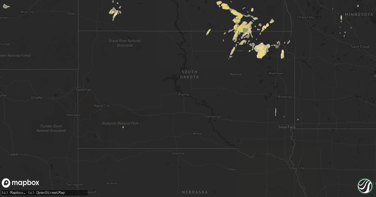
Hail Map in South Dakota on June 19, 2013
Get this storm
June 19 map
$229
one time, instant access
Download today. No call, no setup
Keep the $229
Bought the map and want the full workflow? Apply the entire $229 to a subscription within 7 days. None of it is wasted.
Every map, not just this one
This buys you this map. Subscription and you get every map we run, in the markets you choose from a few cities to whole states to nationwide. Plus real-time alerts the moment a storm fires.
Contact data
Name, contact info, occupancy, even credit band for addresses in the footprint. You go from where it hit to who to call.
Become the source they trust
Unlimited branding weather history reports on demand. You already have the documented answer ready for the property owner, and you are the one who showed up with it.
Property data and RoofTrace estimates
Pull up any address you have got, its value and the exact code rules for that jurisdiction, straight from One Click Code. Then RoofTrace estimates the squares, pitch, and roof value, priced the way you price.
Storm reports in South Dakota
South Dakota
| Date | Description |
|---|---|
| 06/19/20136:50 AM CDT | Mostly pea sized hail with a few stones to the size of quarters. 1.0 inch of rainfall. |
| 06/19/20136:30 AM CDT | Twitter report of ping-pong ball sized hail in bristol |
| 06/19/20136:15 AM CDT | A local report indicates 1.00 inch wind near 6 ENE PIERPONT |
| 06/19/201312:40 AM CDT | Long duration hail event with hail at least to the size of quarters. Hail drifts still evident this morning. Wind driven hail produced major crop damage. |
| 06/19/201312:39 AM CDT | A local report indicates 59 MPH wind near RAPID CITY AIRPORT |
| 06/19/201312:00 AM CDT | Public report of quarter sized hail and winds of 50 to 60 mph. Major crop damage to bean fields and damage to siding on house from wind driven hail. |
| 06/18/201310:09 PM CDT | Nickel to quarter size hail |
All States Impacted by Hail Map on June 19, 2013
Cities Impacted by Hail Map on June 19, 2013
- Breckenridge, TX
- Albany, TX
- Leary, GA
- Savage, MT
- Jayton, TX
- Aspermont, TX
- Hecla, SD
- Levelland, TX
- Wilmot, SD
- Berlin, ND
- Edgeley, ND
- Tatum, NM
- Augusta, MT
- Columbus, MT
- Richey, MT
- Marvin, SD
- Twin Brooks, SD
- Big Timber, MT
- New England, ND
- Crossroads, NM
- Pep, NM
- Rogers, NM
- Milnesand, NM
- Elida, NM
- Pierpont, SD
- Webster, SD
- Langford, SD
- Grenville, SD
- Eden, SD
- Roslyn, SD
- Bristol, SD
- Andover, SD
- Britton, SD
- Watford City, ND
- New Town, ND
- Roundup, MT
- Kingsland, GA
- Saint Marys, GA
- Fernandina Beach, FL
- Yulee, FL
- Moscow, TN
- Avoca, TX
- Rule, TX
- Stamford, TX
- Oakes, ND
- Kulm, ND
- Stirum, ND
- Westport, SD
- Verona, ND
- Fort Ransom, ND
- Columbia, SD
- Cogswell, ND
- Frederick, SD
- Ellendale, ND
- Barnard, SD
- Jud, ND
- Lamoure, ND
- Houghton, SD
- Fullerton, ND
- Kevin, MT
- Browerville, MN
- Regent, ND
- Conchas Dam, NM
- Tucumcari, NM
- Throckmorton, TX
- Sidney, MT
- Havana, ND
- Cayuga, ND
- Forman, ND
- Rutland, ND
- Williston, ND
- Big Sandy, MT
- Childress, TX
- Folsom, NM
- Great Falls, MT
- Crawford, NE
- Raynesford, MT
- Chester, MT
- Sierra Blanca, TX
- Judith Gap, MT
- Buffalo, MT
- Rapelje, MT
- Neihart, MT
- Monarch, MT
- Belt, MT
- Broadview, MT
- Beaufort, SC
- Geraldine, MT
- Mineral Wells, TX
- Fort Benton, MT
- Ipswich, SD
- Aberdeen, SD
- Alma, GA
- Rosebud, MT
- Caddo, TX
- Ormond Beach, FL
- Berthold, ND
- Zahl, ND
- Grenora, ND
- Richmond Hill, GA
- Crowell, TX
- Lidgerwood, ND
- Milnor, ND
- Wyndmere, ND
- Hobson, MT
- Corona, SD
- Silverton, TX
- Groom, TX
- Panhandle, TX
- Claude, TX
- White Sulphur Springs, MT
- Ringling, MT
- Loma, MT
- Fairfield, MT
- Cascade, MT
- Wolf Creek, MT
- Groton, SD
- Paducah, TX
- Ranger, TX
- Cleveland, ND
- Cisco, TX
- Geyser, MT
- Highwood, MT
- Seagraves, TX
- Wibaux, MT
- Leola, SD
- Lavina, MT
- Mandaree, ND
- Pequot Lakes, MN
- Nisswa, MN
- Cohagen, MT
- Sundown, TX
- Parshall, ND
- Henrietta, TX
- Baconton, GA
- Albany, GA
- Roswell, NM
- Balmorhea, TX
- Lake Wales, FL
- Valier, MT
- Hazlehurst, GA
- Forsyth, MT
- Whitlash, MT
- Ryder, ND
- Plaza, ND
- Makoti, ND
- Palermo, ND
- Stanley, ND
- Pecos, TX
- Muleshoe, TX
- Winifred, MT
- Weinert, TX
- Seymour, TX
- Munday, TX
- Benjamin, TX
- Chinook, MT
- Dublin, TX
- Portales, NM
- Epping, ND
- Arnegard, ND
- Alexander, ND
- Girard, TX
- Brusett, MT
- Circle, MT
- Noonan, ND
- Dayton, TX
- Roy, MT
- Groveland, FL
- Lamesa, TX
- Welch, TX
- Choteau, MT
- Musselshell, MT
- Anson, TX
- Powers Lake, ND
- Moran, TX
- Colton, SD
- Madison, SD
- Carbon, TX
- Clarendon, TX
- Garrison, ND
- Ray, ND
- Whiteface, TX
- Mansfield, SD
- Little Falls, MN
- Fellsmere, FL
- Killdeer, ND
- Lambert, MT
- Bloomfield, MT
- Jamestown, ND
- Montpelier, ND
- Eureka, SD
- San Jon, NM
- Old Glory, TX
- Memphis, TX
- Lakeview, TX
- Hedley, TX
- Gackle, ND
- Townsend, MT
- McCaulley, TX
- Hamlin, TX
- Hart, TX
- Ennis, TX
- Palmer, TX
- Toston, MT
- Swanville, MN
- Burtrum, MN
- Jordan, MT
- Tioga, ND
- Tell, TX
- Molt, MT
- Ledger, MT
- Ingomar, MT
- Wadena, MN
- Perry, FL
- Greenville, FL
- Moccasin, MT
- Staples, MN
- Jacksonville, FL
- Mims, FL
- Dell Rapids, SD
- Savannah, GA
- Rebecca, GA
- Esmond, ND
- Hawley, TX
- Live Oak, FL
- White Oak, GA
- Claremont, SD
- Forbes, ND
- Strawn, TX
- Barry, TX
- Winnett, MT
- Beulah, ND
- Hazen, ND
- Melville, MT
- Lockney, TX
- Quitaque, TX
- Odonnell, TX
- Tallahassee, FL
- Houston, TX
- Raton, NM
- Golden Valley, ND
- Roseglen, ND
- Harrison, NE
- Keene, ND
- Tolar, TX
- Long Prairie, MN
- Morgan, GA
- Ringling, OK
- Sisseton, SD
- Mayo, FL
- Day, FL
- Lignite, ND
- Matador, TX
- Turkey, TX
- Flomot, TX
- Quitman, GA
- Rising Star, TX
- Slaton, TX
- Folkston, GA
- Glendive, MT
- Lloyd, MT
- Fort Sumner, NM
- Carter, MT
- Medina, ND
- Okatie, SC
- Arcadia, FL
- Waycross, GA
- Guyton, GA
- Brady, MT
- Springlake, TX
- Earth, TX
- Sudan, TX
- Loving, NM
- Carlsbad, NM
- Ashley, ND
- Galata, MT
- Sweet Grass, MT
- Floweree, MT
- Sheyenne, ND
- Woodbine, GA
- Palo Pinto, TX
- Wayside, TX
- Woodson, TX
- Haskell, TX
- Alamo, ND
- Loxahatchee, FL
- Chadron, NE
- Knox City, TX
- Grey Eagle, MN
- Labelle, FL
- Daytona Beach, FL
- Fortuna, ND
- Sand Springs, MT
- Morton, TX
- Browning, MT
- Doerun, GA
- Hobbs, NM
- Joliet, MT
- Fargo, GA
- Absarokee, MT
- Peever, SD
- Chico, TX
- Bowie, TX
- Stanton, ND
- Van Horn, TX
- Browns Valley, MN
- Beardsley, MN
- Mandan, ND
- Okeechobee, FL
- Bridgeport, TX
- Amidon, ND
- Reeder, ND
- Winston, MT
- Dunn Center, ND
- Stockett, MT
- Monticello, FL
- Streeter, ND
- Kyle, SD
- Pine Ridge, SD
- Bowbells, ND
- Gwinner, ND
- Lincoln, MT
- Hardwick, MN
- Luverne, MN
- Waynesville, GA
- Grassy Butte, ND
- Litchville, ND
- Hardeeville, SC
- Edison, GA
- Saint Cloud, FL
- Lueders, TX
- Abilene, TX
- Cordova, TN
- Ryegate, MT
- Wildrose, ND
- Ypsilanti, ND
- Malta, MT
- Bowdon, ND
- Nicholls, GA
- Dimmitt, TX
- Ashburn, GA
- Rushville, NE
- Max, ND
- Douglas, ND
- Heart Butte, MT
- Center, ND
- Palm Bay, FL
- Logan, NM
- Bard, NM
- Brownfield, TX
- Ackerly, TX


