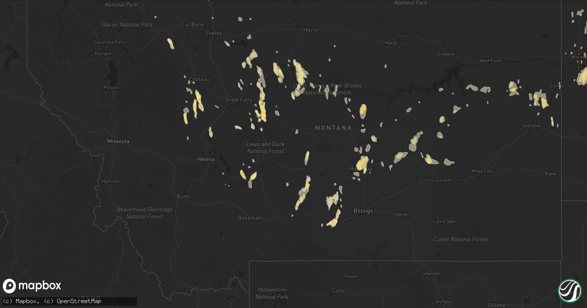
Hail Map in Montana on June 19, 2013
Get this storm
June 19 map
$229
one time, instant access
Download today. No call, no setup
Keep the $229
Bought the map and want the full workflow? Apply the entire $229 to a subscription within 7 days. None of it is wasted.
Every map, not just this one
This buys you this map. Subscription and you get every map we run, in the markets you choose from a few cities to whole states to nationwide. Plus real-time alerts the moment a storm fires.
Contact data
Name, contact info, occupancy, even credit band for addresses in the footprint. You go from where it hit to who to call.
Become the source they trust
Unlimited branding weather history reports on demand. You already have the documented answer ready for the property owner, and you are the one who showed up with it.
Property data and RoofTrace estimates
Pull up any address you have got, its value and the exact code rules for that jurisdiction, straight from One Click Code. Then RoofTrace estimates the squares, pitch, and roof value, priced the way you price.
Storm reports in Montana
Montana
| Date | Description |
|---|---|
| 06/19/20136:51 PM CDT | A local report indicates 59 MPH wind near LIVINGSTON |
| 06/19/20136:15 PM CDT | Second hand report of significant hail damage to a truck on hwy 87. Proximity report would suggest 1.75 inch hail. |
| 06/19/20135:59 PM CDT | Golf-ball sized hail measured. Hail duration 7 minutes. |
| 06/19/20135:25 PM CDT | Dime to quarter sized hail |
| 06/19/20135:15 PM CDT | A local report indicates 1.25 inch wind near 7 E COLUMBUS |
| 06/19/20135:14 PM CDT | A local report indicates 1.00 inch wind near ESE BIG TIMBER |
| 06/19/20135:10 PM CDT | A local report indicates 1.75 inch wind near 4 E COLUMBUS |
| 06/19/20135:00 PM CDT | Pea to quarter sized hail...shredded leaves. |
| 06/19/20134:27 AM CDT | A local report indicates 86 MPH wind near 10 WSW WESTBY |
| 06/19/20132:00 AM CDT | Cow creek dot site on mt 13 at mile post 20 |
| 06/19/20131:40 AM CDT | 6 to 8 inch diameter tree branch was broken off a large tree in the town of circle. |
| 06/19/201312:45 AM CDT | A couple of large trees blown over. Large limbs broken off other trees. |
| 06/19/201312:45 AM CDT | A local report indicates 61 MPH wind near 2 WSW THOENY |
| 06/19/201312:30 AM CDT | A local report indicates 70 MPH wind near 2 NNW GLASGOW |
| 06/19/201312:15 AM CDT | A roof was blown off of a shed and thrown about 75 yards into a field northeast of the shed location. The shed was open faced towards the south...and side walls are sti |
| 06/18/201311:18 PM CDT | 62 mph thunderstorm wind gust reported at fort belknap raws site at 1018 pm mdt. |
| 06/18/201311:08 PM CDT | A local report indicates 59 MPH wind near 7 SE DEVILS CRK REC ARE |
| 06/18/201311:00 PM CDT | 66 mph wind gust measured between 9 and 10 pm. |
| 06/18/201310:30 PM CDT | A local report indicates 66 MPH wind near 11 ENE ZORTMAN |
| 06/18/201310:30 PM CDT | A local report indicates 59 MPH wind near 23 N HAVRE |
| 06/18/201310:27 PM CDT | 59 mph thunderstorm wind gust reported at havre city county airport asos at 927 pm mdt. |
| 06/18/201310:15 PM CDT | A local report indicates 58 MPH wind near 15 S ZORTMAN |
| 06/18/201310:10 PM CDT | Numerous power poles snapped off. |
| 06/18/201310:10 PM CDT | Two 5000 gallon oilfield tanks were pushed uphill from their storage area and located 1 mile away. |
| 06/18/20139:55 PM CDT | Estimated wind gusts to 60 mph. |
| 06/18/20139:42 PM CDT | 60 mph thunderstorm wind gust reported at havre city county airport asos at 842 pm mdt. |
| 06/18/20139:37 PM CDT | Spotter estimates winds of 60 mph. |
| 06/18/20139:20 PM CDT | Nickel to quarter sized hail...estimated 70 to 80 mph winds. Possible microburst. Flash flooding on property. |
| 06/18/20139:20 PM CDT | 62 mph thunderstorm wind gust reported at lewistown municipal airport asos at 820 pm mdt. |
| 06/18/20139:20 PM CDT | A local report indicates 60 MPH wind near 7 NE BOX ELDER |
| 06/18/20139:16 PM CDT | A local report indicates 1.00 inch wind near ROUNDUP |
| 06/18/20139:15 PM CDT | Quarter to half dollar sized hail with 50 mph winds |
| 06/18/20139:15 PM CDT | A local report indicates 62 MPH wind near 1 NNW ROUNDUP |
| 06/18/20139:10 PM CDT | Quarter sized hail found on ground amid a covering of smaller hail. Estimated 60 mph winds. Mm 29 on hwy 223. |
| 06/18/20139:00 PM CDT | Large tree branches down |
| 06/18/20139:00 PM CDT | Pea to quarter sized hail |
| 06/18/20139:00 PM CDT | Pea to quarter sized hail with estimated wind gusts of 50 mph. |
| 06/18/20139:00 PM CDT | Dime to quarter sized hail |
| 06/18/20138:58 PM CDT | Three inch tree branch broken by estimated 45 mph west wind. |
| 06/18/20138:54 PM CDT | Asos measured 81 mph thunderstorm wind gust. Lewistown sheriff reports numerous trees down. |
| 06/18/20138:31 PM CDT | Judith gap dot |
| 06/18/20138:09 PM CDT | A local report indicates 1.00 inch wind near SW RAPELJE |
| 06/18/20138:00 PM CDT | Estimated 60 mph wind gust with heavy rain. No hail. |
| 06/18/20137:00 PM CDT | A local report indicates 58 MPH wind near GREAT FALLS |
All States Impacted by Hail Map on June 19, 2013
Cities Impacted by Hail Map on June 19, 2013
- Breckenridge, TX
- Albany, TX
- Leary, GA
- Savage, MT
- Jayton, TX
- Aspermont, TX
- Hecla, SD
- Levelland, TX
- Wilmot, SD
- Berlin, ND
- Edgeley, ND
- Tatum, NM
- Augusta, MT
- Columbus, MT
- Richey, MT
- Marvin, SD
- Twin Brooks, SD
- Big Timber, MT
- New England, ND
- Crossroads, NM
- Pep, NM
- Rogers, NM
- Milnesand, NM
- Elida, NM
- Pierpont, SD
- Webster, SD
- Langford, SD
- Grenville, SD
- Eden, SD
- Roslyn, SD
- Bristol, SD
- Andover, SD
- Britton, SD
- Watford City, ND
- New Town, ND
- Roundup, MT
- Kingsland, GA
- Saint Marys, GA
- Fernandina Beach, FL
- Yulee, FL
- Moscow, TN
- Avoca, TX
- Rule, TX
- Stamford, TX
- Oakes, ND
- Kulm, ND
- Stirum, ND
- Westport, SD
- Verona, ND
- Fort Ransom, ND
- Columbia, SD
- Cogswell, ND
- Frederick, SD
- Ellendale, ND
- Barnard, SD
- Jud, ND
- Lamoure, ND
- Houghton, SD
- Fullerton, ND
- Kevin, MT
- Browerville, MN
- Regent, ND
- Conchas Dam, NM
- Tucumcari, NM
- Throckmorton, TX
- Sidney, MT
- Havana, ND
- Cayuga, ND
- Forman, ND
- Rutland, ND
- Williston, ND
- Big Sandy, MT
- Childress, TX
- Folsom, NM
- Great Falls, MT
- Crawford, NE
- Raynesford, MT
- Chester, MT
- Sierra Blanca, TX
- Judith Gap, MT
- Buffalo, MT
- Rapelje, MT
- Neihart, MT
- Monarch, MT
- Belt, MT
- Broadview, MT
- Beaufort, SC
- Geraldine, MT
- Mineral Wells, TX
- Fort Benton, MT
- Ipswich, SD
- Aberdeen, SD
- Alma, GA
- Rosebud, MT
- Caddo, TX
- Ormond Beach, FL
- Berthold, ND
- Zahl, ND
- Grenora, ND
- Richmond Hill, GA
- Crowell, TX
- Lidgerwood, ND
- Milnor, ND
- Wyndmere, ND
- Hobson, MT
- Corona, SD
- Silverton, TX
- Groom, TX
- Panhandle, TX
- Claude, TX
- White Sulphur Springs, MT
- Ringling, MT
- Loma, MT
- Fairfield, MT
- Cascade, MT
- Wolf Creek, MT
- Groton, SD
- Paducah, TX
- Ranger, TX
- Cleveland, ND
- Cisco, TX
- Geyser, MT
- Highwood, MT
- Seagraves, TX
- Wibaux, MT
- Leola, SD
- Lavina, MT
- Mandaree, ND
- Pequot Lakes, MN
- Nisswa, MN
- Cohagen, MT
- Sundown, TX
- Parshall, ND
- Henrietta, TX
- Baconton, GA
- Albany, GA
- Roswell, NM
- Balmorhea, TX
- Lake Wales, FL
- Valier, MT
- Hazlehurst, GA
- Forsyth, MT
- Whitlash, MT
- Ryder, ND
- Plaza, ND
- Makoti, ND
- Palermo, ND
- Stanley, ND
- Pecos, TX
- Muleshoe, TX
- Winifred, MT
- Weinert, TX
- Seymour, TX
- Munday, TX
- Benjamin, TX
- Chinook, MT
- Dublin, TX
- Portales, NM
- Epping, ND
- Arnegard, ND
- Alexander, ND
- Girard, TX
- Brusett, MT
- Circle, MT
- Noonan, ND
- Dayton, TX
- Roy, MT
- Groveland, FL
- Lamesa, TX
- Welch, TX
- Choteau, MT
- Musselshell, MT
- Anson, TX
- Powers Lake, ND
- Moran, TX
- Colton, SD
- Madison, SD
- Carbon, TX
- Clarendon, TX
- Garrison, ND
- Ray, ND
- Whiteface, TX
- Mansfield, SD
- Little Falls, MN
- Fellsmere, FL
- Killdeer, ND
- Lambert, MT
- Bloomfield, MT
- Jamestown, ND
- Montpelier, ND
- Eureka, SD
- San Jon, NM
- Old Glory, TX
- Memphis, TX
- Lakeview, TX
- Hedley, TX
- Gackle, ND
- Townsend, MT
- McCaulley, TX
- Hamlin, TX
- Hart, TX
- Ennis, TX
- Palmer, TX
- Toston, MT
- Swanville, MN
- Burtrum, MN
- Jordan, MT
- Tioga, ND
- Tell, TX
- Molt, MT
- Ledger, MT
- Ingomar, MT
- Wadena, MN
- Perry, FL
- Greenville, FL
- Moccasin, MT
- Staples, MN
- Jacksonville, FL
- Mims, FL
- Dell Rapids, SD
- Savannah, GA
- Rebecca, GA
- Esmond, ND
- Hawley, TX
- Live Oak, FL
- White Oak, GA
- Claremont, SD
- Forbes, ND
- Strawn, TX
- Barry, TX
- Winnett, MT
- Beulah, ND
- Hazen, ND
- Melville, MT
- Lockney, TX
- Quitaque, TX
- Odonnell, TX
- Tallahassee, FL
- Houston, TX
- Raton, NM
- Golden Valley, ND
- Roseglen, ND
- Harrison, NE
- Keene, ND
- Tolar, TX
- Long Prairie, MN
- Morgan, GA
- Ringling, OK
- Sisseton, SD
- Mayo, FL
- Day, FL
- Lignite, ND
- Matador, TX
- Turkey, TX
- Flomot, TX
- Quitman, GA
- Rising Star, TX
- Slaton, TX
- Folkston, GA
- Glendive, MT
- Lloyd, MT
- Fort Sumner, NM
- Carter, MT
- Medina, ND
- Okatie, SC
- Arcadia, FL
- Waycross, GA
- Guyton, GA
- Brady, MT
- Springlake, TX
- Earth, TX
- Sudan, TX
- Loving, NM
- Carlsbad, NM
- Ashley, ND
- Galata, MT
- Sweet Grass, MT
- Floweree, MT
- Sheyenne, ND
- Woodbine, GA
- Palo Pinto, TX
- Wayside, TX
- Woodson, TX
- Haskell, TX
- Alamo, ND
- Loxahatchee, FL
- Chadron, NE
- Knox City, TX
- Grey Eagle, MN
- Labelle, FL
- Daytona Beach, FL
- Fortuna, ND
- Sand Springs, MT
- Morton, TX
- Browning, MT
- Doerun, GA
- Hobbs, NM
- Joliet, MT
- Fargo, GA
- Absarokee, MT
- Peever, SD
- Chico, TX
- Bowie, TX
- Stanton, ND
- Van Horn, TX
- Browns Valley, MN
- Beardsley, MN
- Mandan, ND
- Okeechobee, FL
- Bridgeport, TX
- Amidon, ND
- Reeder, ND
- Winston, MT
- Dunn Center, ND
- Stockett, MT
- Monticello, FL
- Streeter, ND
- Kyle, SD
- Pine Ridge, SD
- Bowbells, ND
- Gwinner, ND
- Lincoln, MT
- Hardwick, MN
- Luverne, MN
- Waynesville, GA
- Grassy Butte, ND
- Litchville, ND
- Hardeeville, SC
- Edison, GA
- Saint Cloud, FL
- Lueders, TX
- Abilene, TX
- Cordova, TN
- Ryegate, MT
- Wildrose, ND
- Ypsilanti, ND
- Malta, MT
- Bowdon, ND
- Nicholls, GA
- Dimmitt, TX
- Ashburn, GA
- Rushville, NE
- Max, ND
- Douglas, ND
- Heart Butte, MT
- Center, ND
- Palm Bay, FL
- Logan, NM
- Bard, NM
- Brownfield, TX
- Ackerly, TX


