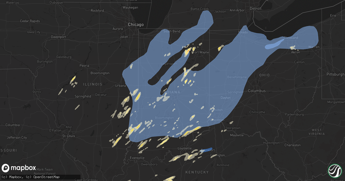
Hail Map in Indiana on June 18, 2025
Get this storm
June 18 map
$229
one time, instant access
Download today. No call, no setup
Keep the $229
Bought the map and want the full workflow? Apply the entire $229 to a subscription within 7 days. None of it is wasted.
Every map, not just this one
This buys you this map. Subscription and you get every map we run, in the markets you choose from a few cities to whole states to nationwide. Plus real-time alerts the moment a storm fires.
Contact data
Name, contact info, occupancy, even credit band for addresses in the footprint. You go from where it hit to who to call.
Become the source they trust
Unlimited branding weather history reports on demand. You already have the documented answer ready for the property owner, and you are the one who showed up with it.
Property data and RoofTrace estimates
Pull up any address you have got, its value and the exact code rules for that jurisdiction, straight from One Click Code. Then RoofTrace estimates the squares, pitch, and roof value, priced the way you price.
Storm reports in Indiana
Indiana
| Date | Description |
|---|---|
| 06/18/20256:07 PM CDT | Several trees blown down on the north side of rising sun. A power pole supporting tornado sirens was also blown over. |
| 06/18/20255:29 PM CDT | Multiple power lines down- time est from radar. |
| 06/18/20255:20 PM CDT | A local report indicates 68 MPH wind near Brookville |
| 06/18/20255:20 PM CDT | Several healthy trees were downed either by being split or being uprooted. |
| 06/18/20255:17 PM CDT | Tree down across state route 1. |
| 06/18/20255:15 PM CDT | Several trees down near i-74 between mile |
| 06/18/20255:15 PM CDT | Several trees and tree limbs down. Time estimated by radar. |
| 06/18/20255:15 PM CDT | Several trees down near i-74 between mile markers 149 and 153. Time estimated by radar. |
| 06/18/20255:14 PM CDT | Downed power poles and lines. |
| 06/18/20254:56 PM CDT | Large tree uprooted. |
| 06/18/20254:55 PM CDT | Corrects event type of previous non-tstm wnd gst report from 1 n portland. Awos station kpld 1 n portland. |
| 06/18/20254:55 PM CDT | Awos station kpld 1 n portland. |
| 06/18/20254:52 PM CDT | Twelve-inch diameter pine tree split in half. |
| 06/18/20254:50 PM CDT | Tree down on utility lines and hanging into road. |
| 06/18/20254:47 PM CDT | Four-inch live tree limbs were blown down into the street by thunderstorm winds at 8th street just east of port street. |
| 06/18/20254:47 PM CDT | Large pine tree down. |
| 06/18/20254:46 PM CDT | Twenty-inch diameter live tree was blown down by thunderstorm winds. |
| 06/18/20254:44 PM CDT | A local report indicates 60 MPH wind near 4 N Glenwood |
| 06/18/20254:43 PM CDT | Part of a roof blown off of a commercial building and many power lines down. |
| 06/18/20254:42 PM CDT | Time estimated from radar. Wind damage occurred to a front yard tree and a garage. |
| 06/18/20254:36 PM CDT | Time estimated from radar. A tree was split about 10 feet up that may have been previously compromised. |
| 06/18/20254:31 PM CDT | Rat least 1 tree uprooted onto a power line on s dill st near washington st at least 3 trees had limbs broken off across from white river blvd between w jackson st and |
| 06/18/20254:30 PM CDT | Time is estimated from radar. Winds hit a mobile home park in muncie... Uprooting a tree halfway up that fell on a mobile home. No injuries. |
| 06/18/20254:30 PM CDT | Time is estimated from radar. A tree or large tree branch was blown down on 6th street near emerson elementary school. Relayed by wymt-tv. |
| 06/18/20254:30 PM CDT | Large tree down in jonesboro. |
| 06/18/20254:30 PM CDT | Tree into a house at market and ivy in rushville. No injuries. Multiple trees and power lines down across the county. |
| 06/18/20254:30 PM CDT | Time estimated from radar. Large tree branch was blown down by thunderstorm winds. |
| 06/18/20254:30 PM CDT | Time estimated from radar. Live 14-inch diameter tree was blown down by thunderstorm winds onto a house that did not sustain damage. |
| 06/18/20254:29 PM CDT | Two 18-inch diameter live trees sheared off approximately 50 feet up and fell on a house. |
| 06/18/20254:29 PM CDT | Downed power lines and tree branches 3 to 3.5 inches in diameter along with various debris was caused by thunderstorm winds. |
| 06/18/20254:29 PM CDT | A local report indicates 73 MPH wind near 2 SW Royerton |
| 06/18/20254:28 PM CDT | Tree and utility lines were blown down by thunderstorm winds. Relayed by ema. |
| 06/18/20254:27 PM CDT | Large billboard blow over. Measured gust to just over 60 mph. |
| 06/18/20254:25 PM CDT | Report from mping: half dollar |
| 06/18/20254:24 PM CDT | Report from mping: ping pong ball |
| 06/18/20254:24 PM CDT | Time estimated from radar. Multiple trees and wires down across the county with a few roads blocked. Report of one tree on the roof of a house in columbus with no injur |
| 06/18/20254:21 PM CDT | Large tree down... Fence blown over. Time estimated by radar. Report via twitter. |
| 06/18/20254:20 PM CDT | Report from mping: ping pong ball |
| 06/18/20254:19 PM CDT | Near cr 50 w and cr 800 n...6 live trees were blown down. |
| 06/18/20254:18 PM CDT | Large tree branches down blocking roadway. |
| 06/18/20254:18 PM CDT | Time estimated from radar. Tree into a residence 200 blk w broadway... No injuries. Multiple small limbs down and a few larger limbs... Traffic is not affected. |
| 06/18/20254:18 PM CDT | Time estimated from radar. Tree into a residen down in stow. |
| 06/18/20254:17 PM CDT | Multiple tree branches down. |
| 06/18/20254:16 PM CDT | Report from mping: quarter |
| 06/18/20254:16 PM CDT | Near abe martin road in brown county state park...tree blown down on car with people trapped. |
| 06/18/20254:15 PM CDT | 3 to 5 inch diamater tree branches down. |
| 06/18/20254:15 PM CDT | Tree down on power lines. |
| 06/18/20254:14 PM CDT | Tree down across state rd 3. |
| 06/18/20254:12 PM CDT | A local report indicates 62 MPH wind near 1 NW Spurgeons Corner |
| 06/18/20254:12 PM CDT | Large limbs snapped. |
| 06/18/20254:12 PM CDT | Time estimated from radar. Several trees and branches down in town. Two streets blocked. |
| 06/18/20254:10 PM CDT | Six-inch tree limb blocking sr 234 at 400 west. Time approximated from radar. |
| 06/18/20254:08 PM CDT | Large tree down at the intersection of s 300 w and w 400 s. Time estimated via radar. |
| 06/18/20254:06 PM CDT | Sixteen-inch diameter healthy live tree limbs broken and partially blocking roadway. |
| 06/18/20254:06 PM CDT | Multiple trees down on sr 135 from thunderstorm winds. |
| 06/18/20254:06 PM CDT | Multiple tree limbs down of one to two inches thick. Pea to dime size hail. |
| 06/18/20254:06 PM CDT | Four inches of water across road. |
| 06/18/20254:05 PM CDT | Trees and power lines down across area with power outages. |
| 06/18/20254:02 PM CDT | Power lines down. |
| 06/18/20254:02 PM CDT | Numerous large oak trees down. |
| 06/18/20254:01 PM CDT | A local report indicates 60 MPH wind near Marion |
| 06/18/20254:00 PM CDT | Twelve 12 tree down blocking southbound sr67. Time is approximate. |
| 06/18/20254:00 PM CDT | Delayed report...time unknown...6-8-inch diameter live tree down across the road from thunderstorm winds. |
| 06/18/20254:00 PM CDT | Time estimated from radar. Considerable tree limbs and tree debris in camp kikthawenund. No damage or injuries. |
| 06/18/20253:55 PM CDT | Seven-inch tree limb was blown down by thunderstorm winds at 25th street and post road. |
| 06/18/20253:55 PM CDT | Several 2-3 live tree limbs across power lines from thunderstorm winds. |
| 06/18/20253:55 PM CDT | 2 trees down in the roadway. |
| 06/18/20253:55 PM CDT | Several 2-3 live tree limbs across power lines. |
| 06/18/20253:55 PM CDT | Large tree branch down. Report via twitter. |
| 06/18/20253:54 PM CDT | Power lines down. |
| 06/18/20253:54 PM CDT | Accompanied by 0.70-inch of rain in 10 minutes. |
| 06/18/20253:54 PM CDT | Time estimated from radar. A tree was down onto utility lines with 3 to 5-inch diameter branches broken off across state road 135 due to thunderstorm winds. |
| 06/18/20253:54 PM CDT | Tree down on twin oaks drive in middlebury. Time estimated via radar. |
| 06/18/20253:53 PM CDT | Tree fallen onto two vehicles in cumberland. Ce 200 blk w broadway... No injuries. Multiple small limbs down and a few larger limbs... Traffi |
| 06/18/20253:53 PM CDT | A local report indicates 67 MPH wind near Warren Park |
| 06/18/20253:53 PM CDT | Tree fallen onto two vehicles in cumberland. |
| 06/18/20253:52 PM CDT | Quarter size hail near west county road 525 south and county road 550 south. |
| 06/18/20253:51 PM CDT | Six-inch diameter tree limb down was blown down at arlington avenue and thompson road in marion county. |
| 06/18/20253:50 PM CDT | Photos of quarter size hail in south whitley. Tim estimated via radar. |
| 06/18/20253:50 PM CDT | Tree and power line down on whiteland rd at 75w. Relayed via twitter. Time estimated from radar. |
| 06/18/20253:50 PM CDT | Several 3 to 5 inch diameter limbs from healthy catalpa tree down. Report via twitter. Time estimated from radar. |
| 06/18/20253:50 PM CDT | Barn roof damaged. Pieces of sheet metal torn off. |
| 06/18/20253:49 PM CDT | Ping pong to golf ball size hail in south whitley. Time estimated via radar. |
| 06/18/20253:49 PM CDT | Near mooresville. |
| 06/18/20253:49 PM CDT | Near browns crossing. |
| 06/18/20253:48 PM CDT | Time estimated from radar. A large tree limb split off about about 2 feet up from the tree base on a tree with a health issue but otherwise full of foliage. It caused m |
| 06/18/20253:45 PM CDT | Large tree and power lines down across ritter at pleasant run... Estunated 65 to 70 mph gusts. |
| 06/18/20253:45 PM CDT | Large tree uprooted on house near fall creek and castleton. Reported via twitter. Time estimated via radar. |
| 06/18/20253:43 PM CDT | Eight-inch diameter live tree down near carr road and us 40 from thunderstorm winds. |
| 06/18/20253:43 PM CDT | Public report - quarter |
| 06/18/20253:42 PM CDT | Time is estimated from radar. A large tree limb was blown down by thunderstorm winds onto southbound lanes of keystone avenue between 106th street and 116th street. |
| 06/18/20253:42 PM CDT | Trained spotter estimates 2 minutes of 60 mph gusts in goshen. |
| 06/18/20253:42 PM CDT | Large tree down on sr 15 near the goshen public library. Time estimated via radar. |
| 06/18/20253:42 PM CDT | Large tree down on cr 113 near cr 26 and cr 28 in dunlap. Time estimated via radar. |
| 06/18/20253:42 PM CDT | Time has been estimated from radar. Trees and tree limbs were blown down by thunderstorm winds on alabama street near 14 street. |
| 06/18/20253:40 PM CDT | Two tree tops broken off. Report via twitter. Time estimated from radar. |
| 06/18/20253:40 PM CDT | Trees and utility lines were blown down by thunderstorm winds. Time estimated from radar. |
| 06/18/20253:40 PM CDT | Multiple trees damaged. |
| 06/18/20253:37 PM CDT | Tree blown down by thunderstorm winds. |
| 06/18/20253:32 PM CDT | Tree blocking 1 ln of travel. |
| 06/18/20253:32 PM CDT | A local report indicates 71 MPH wind near 1 SSW Indianapolis Int' |
| 06/18/20253:32 PM CDT | Estimating 70 mph winds. |
| 06/18/20253:31 PM CDT | Powerlines down on cr50 between cr 13 and cr 15. |
| 06/18/20253:30 PM CDT | Multiple reports of trees down across town. Time estimated. |
| 06/18/20253:30 PM CDT | Tree down blocking road in front of brooklyn elementary school. Time is approximate. |
| 06/18/20253:30 PM CDT | Off duty nws employee reports trees down on levi lee rd near leesburg. Time estimated via radar. |
| 06/18/20253:30 PM CDT | A local report indicates 63 MPH wind near 6 ENE Whitestown |
| 06/18/20253:30 PM CDT | 1.5 foot diameter limb down from live walnut tree. Time estimated. |
| 06/18/20253:30 PM CDT | Time estimated from radar. A large maple tree was blown down by thunderstorm winds with an estimated 4.5-foot diameter base. The tree had health issues in the base but |
| 06/18/20253:29 PM CDT | Large tree down at hums elementary school. Time estimated via radar. |
| 06/18/20253:28 PM CDT | 60 to 70 mph gusts estimated. 8.5 inch limbs down. |
| 06/18/20253:28 PM CDT | A local report indicates 62 MPH wind near 1 S Tippecanoe |
| 06/18/20253:26 PM CDT | Video shows a large tree limb fell onto powerlines outside of a home on n 175 e. No injuries reported. |
| 06/18/20253:26 PM CDT | Video shows a large tree limb fell onto powerlines outside of a home on n 175 e. No injuries reported. |
| 06/18/20253:25 PM CDT | Large tree down on east center street in warsaw. Time estimated via radar. |
| 06/18/20253:25 PM CDT | Tree down onto power lines which resulted in a fire. |
| 06/18/20253:25 PM CDT | Power poles down at intersection of omega drive and west division road. |
| 06/18/20253:25 PM CDT | Trees and power lines down. |
| 06/18/20253:25 PM CDT | Multiple trees and limbs down on stafford rd. Time estimated. |
| 06/18/20253:25 PM CDT | Minor roof damage to a home on the north side of warsaw. Shingles removed. Time estimated via radar. |
| 06/18/20253:24 PM CDT | Time estimated from radar. Lots of large limbs down at this point. All pointed in east direction. |
| 06/18/20253:23 PM CDT | Tree down. |
| 06/18/20253:20 PM CDT | Tree down across road. |
| 06/18/20253:20 PM CDT | Estimated 60 mph winds and pea size hail. |
| 06/18/20253:20 PM CDT | Large tree down across road. |
| 06/18/20253:20 PM CDT | Tree down blocking both lanes. |
| 06/18/20253:20 PM CDT | *** 1 inj *** many trees down along williams road ne of shoals. One tree fell on a house injuring 1 person. |
| 06/18/20253:18 PM CDT | Minor damage to siding to a home on the south side of south bend. Time estimated via radar. |
| 06/18/20253:17 PM CDT | Tree down blocking road. |
| 06/18/20253:16 PM CDT | Corrects time for previous tstm wnd dmg report from 1 se kyana. Tree down blocking both lanes. |
| 06/18/20253:15 PM CDT | Asos station ksbn south bend international ap. |
| 06/18/20253:15 PM CDT | Large tree limbs down onto sheds on the south side of south bend. Time estimated via radar. |
| 06/18/20253:14 PM CDT | Trees and power lines down as well. |
| 06/18/20253:11 PM CDT | Measured at wtwo. |
| 06/18/20253:10 PM CDT | Large limb down. |
| 06/18/20253:10 PM CDT | Downed powerlines between tippecanoe and mentone. Time estimated via radar. |
| 06/18/20253:10 PM CDT | Corrects previous tstm wnd gst report from 1 s tippecanoe. Time estimated via radar. |
| 06/18/20253:08 PM CDT | 2 large trees down at broadway st and 1st st in argos. Time estimated via radar. |
| 06/18/20253:06 PM CDT | Tree limb snapped on a maple tree. |
| 06/18/20253:01 PM CDT | A local report indicates 63 MPH wind near 2 S Cloverdale |
| 06/18/20253:01 PM CDT | Trees down on roads and houses. |
| 06/18/20252:58 PM CDT | Several large trees downed. |
| 06/18/20252:58 PM CDT | Thunderstorm winds blew down a 12-inch tree limb on 9th street between indiana and delaware streets in terre haute. |
| 06/18/20252:58 PM CDT | Corrects previous tstm wnd dmg report from 2 wsw jasper. Power poles down at intersection of omega drive and west division road. |
| 06/18/20252:56 PM CDT | Tree or tree limb blown down by thunderstorm winds. |
| 06/18/20252:54 PM CDT | 10 to 15-inch diameter tree limb blown down onto house. |
| 06/18/20252:54 PM CDT | 10 to 15-inch diameter tree limb blown down onto house. |
| 06/18/20252:50 PM CDT | Tree blown down from thunderstorm winds. Report originated from ema per caller. |
| 06/18/20252:50 PM CDT | Multiple trees down. |
| 06/18/20252:50 PM CDT | Big tree down. A couple inches of water on the road... Not flowing. |
| 06/18/20252:49 PM CDT | Numerous trees down northern vigo county...no specific locations mentioned. |
| 06/18/20252:49 PM CDT | Awos station kppo la porte. |
| 06/18/20252:47 PM CDT | Large tree down with lines across roadway. |
| 06/18/20252:46 PM CDT | Tree down across roadway. |
| 06/18/20252:45 PM CDT | Multiple trees down. |
| 06/18/20252:43 PM CDT | Tree damage near i-70 north of center point. Report via twitter. |
| 06/18/20252:42 PM CDT | Indot shared video of a brief possible spin up tornado in a field north of us 30 and sr 39. No damage seen in video. Time estimated via radar. |
| 06/18/20252:40 PM CDT | Several trees down. Large tree fell on garage. |
| 06/18/20252:40 PM CDT | Large branches down. |
| 06/18/20252:40 PM CDT | Trees and power lines down. |
| 06/18/20252:38 PM CDT | Powerlines down near the intersection of us 30 and us 421 near wanatah. Time estimated by radar. |
| 06/18/20252:38 PM CDT | Us 421 is closed between us 30 and cr 1350 south due to numerous downed powerlines and damaged utility poles in the roadway. Time estimated via radar. |
| 06/18/20252:35 PM CDT | Power lines down. Power out in la crosse... Wanatah and union mills. |
| 06/18/20252:35 PM CDT | Small branches broken. Heavy rain and near zero visibility. |
| 06/18/20252:32 PM CDT | Trees and limbs down in the area. Time estimated from radar. |
| 06/18/20252:31 PM CDT | Trees blocking roads across town... Trees on powerlines and report of a tree on a home. Time estimated from radar. |
| 06/18/20252:30 PM CDT | Corrects previous tstm wnd dmg report from 1 s kouts. Trees down on roads and houses. |
| 06/18/20252:30 PM CDT | Multiple trees reported down. With trees blocking roadways near alice/jefferson/s kouts. |
| 06/18/20252:29 PM CDT | A local report indicates 63 MPH wind near 2 N Kouts |
| 06/18/20252:28 PM CDT | Reports of tree damage nearby. |
| 06/18/20252:26 PM CDT | Tree blown down by thunderstorm winds. |
| 06/18/20252:24 PM CDT | Tree down at indiana beach campground. Time estimated via radar. |
| 06/18/20252:24 PM CDT | Numerous power outages reported. |
| 06/18/20252:23 PM CDT | Tree limb down and numerous other downed trees across the area. Time estimated from radar. |
| 06/18/20252:21 PM CDT | Numerous reports of trees down across vincennes. Time estimated. |
| 06/18/20252:20 PM CDT | Large tree branches fell onto car and townhomes. Very large tree uprooted. Power lines down. |
| 06/18/20252:19 PM CDT | 12-14 inch diameter tree down. |
| 06/18/20252:18 PM CDT | A local report indicates 60 MPH wind near 3 N Indiana State Unive |
| 06/18/20252:18 PM CDT | Report shared via social media of large tree branch or tree downed along 500w road near 1050 road southeast of de motte. Time estimated by radar. |
| 06/18/20252:17 PM CDT | 50mph wind gust with several tree limbs down. Sizes around 3 inches in diameter. |
| 06/18/20252:17 PM CDT | Numerous trees and power lines reported down across a large corridor. Ranging from 1300n and 100e to 1300n and 400e... Then south to county road 1200/sr-10. |
| 06/18/20252:15 PM CDT | Downed power lines on 26 west of lafayette. Report on twitter. Time estimated. |
| 06/18/20252:11 PM CDT | Large tree limbs snapped and power poles leaning. Time estimated. |
| 06/18/20252:10 PM CDT | A brief tornado caused damage west and northwest of lafay |
| 06/18/20252:10 PM CDT | A brief tornado caused damage west and northwest of lafayette. It showed signs of skipping along its path...which was accompanied by significant straight line wind dama |
| 06/18/20252:06 PM CDT | Public report shared via social media of downed tree branch on grace street near the iroquois river in rensselaer. Time estimated by radar. |
| 06/18/20252:05 PM CDT | Live branch down over 2 inch diameter. Time estimated from radar. |
| 06/18/20252:02 PM CDT | A brief tornado caused damage west and northwest of lafayette. It showed signs of skipping along its path...which was accompanied by significant straight line wind dama |
| 06/18/20251:55 PM CDT | Tree damage over a few blocks and stop signs blow over on the southern portion of pine village. Twitter report. Time estimated from radar. |
| 06/18/20251:50 PM CDT | Multiple large tree branches and trunks snapped. Times estimated from radar. |
| 06/18/20251:45 PM CDT | Public report received of tree and crop damage near earl park. Time estimated by radar. |
| 06/18/20251:33 PM CDT | A local report indicates 60 MPH wind near 2 E Gessie |
| 06/18/202512:56 PM CDT | Tree down. |
| 06/17/20259:46 PM CDT | Treen in roadway along tunnel mill road. |
| 06/17/20259:42 PM CDT | Tree onto powerlines and a shed. |
| 06/17/20259:38 PM CDT | Tree damage caused a fire. |
| 06/17/20259:36 PM CDT | Trees in roadway and power lines down. |
All States Impacted by Hail Map on June 18, 2025
Cities Impacted by Hail Map on June 18, 2025
- Seminole, OK
- Washington, OK
- Purcell, OK
- Noble, OK
- Lexington, OK
- Wewoka, OK
- Norman, OK
- Wanette, OK
- Meredosia, IL
- Chambersburg, IL
- Arenzville, IL
- Beardstown, IL
- Virginia, IL
- Kilbourne, IL
- Bath, IL
- Havana, IL
- Topeka, IL
- Easton, IL
- Oakford, IL
- Chandlerville, IL
- Petersburg, IL
- Nebo, IL
- Clarksville, MO
- Greenleaf, KS
- Jacksonville, IL
- Winchester, IL
- Chapin, IL
- Barnes, KS
- Palmyra, IL
- Girard, IL
- Modesto, IL
- Virden, IL
- Ashland, IL
- Frankfort, KS
- Sigel, IL
- Auburn, IL
- Neoga, IL
- Tallula, IL
- Montrose, IL
- Charleston, IL
- Westmoreland, KS
- Thomasville, AL
- Trilla, IL
- Mattoon, IL
- Newman, IL
- Jewett, IL
- Hindsboro, IL
- Oakland, IL
- Ashmore, IL
- Toledo, IL
- Fairfield, IL
- Burtonsville, MD
- Silver Spring, MD
- Laurel, MD
- Effingham, IL
- Royal, IL
- Saint Joseph, IL
- Ogden, IL
- Armstrong, IL
- Fithian, IL
- Penfield, IL
- Collison, IL
- Potomac, IL
- Danville, IL
- Cisne, IL
- Annapolis Junction, MD
- Fort George G Meade, MD
- Geff, IL
- Milford, IL
- Cissna Park, IL
- Brocton, IL
- Jessup, MD
- Hanover, MD
- Savage, MD
- Hidalgo, IL
- Greenup, IL
- Hume, IL
- Severn, MD
- Beltsville, MD
- Johnsonville, IL
- Keenes, IL
- Rossville, IL
- Alvin, IL
- Henning, IL
- Hoopeston, IL
- Casey, IL
- Sims, IL
- Tyler, AL
- Paris, IL
- Watseka, IL
- Mount Erie, IL
- Clay City, IL
- Ridge Farm, IL
- Indianola, IL
- Chrisman, IL
- Georgetown, IL
- Westfield, IL
- Sidell, IL
- Metcalf, IL
- Martinsville, IL
- Kansas, IL
- Odenton, MD
- Gambrills, MD
- Glen Burnie, MD
- Gifford, IL
- Rantoul, IL
- Ludlow, IL
- Paxton, IL
- Rankin, IL
- Buckley, IL
- Loda, IL
- Wellington, IL
- Onarga, IL
- Fowler, IN
- Ambia, IN
- Crescent City, IL
- Sheldon, IL
- Homer, IL
- Fairmount, IL
- Catlin, IL
- Muncie, IL
- Oakwood, IL
- Westville, IL
- Tilton, IL
- State Line, IN
- Covington, IN
- West Lebanon, IN
- Williamsport, IN
- Bismarck, IL
- Boswell, IN
- Perrysville, IN
- Cayuga, IN
- Dana, IN
- Hillsdale, IN
- Veedersburg, IN
- Bloomingdale, IN
- Kingman, IN
- Montezuma, IN
- Iroquois, IL
- Stockland, IL
- Kentland, IN
- Earl Park, IN
- Donovan, IL
- Morocco, IN
- Brook, IN
- Oxford, IN
- Pine Village, IN
- Hillsboro, IN
- Marshall, IN
- Attica, IN
- Fair Oaks, IN
- Rensselaer, IN
- Goodland, IN
- Severna Park, MD
- Millersville, MD
- Crownsville, MD
- Clanton, AL
- Graysville, AL
- Stanberry, MO
- Clyde, MO
- Marshall, IL
- Glenn Dale, MD
- Greenbelt, MD
- Lanham, MD
- Autaugaville, AL
- Selma, AL
- Noble, IL
- Sumner, IL
- Parkersburg, IL
- Calhoun, IL
- Claremont, IL
- Mount Ayr, IN
- Wolcott, IN
- Remington, IN
- Templeton, IN
- West Lafayette, IN
- Chalmers, IN
- Otterbein, IN
- Brookston, IN
- New Richmond, IN
- Waveland, IN
- Lafayette, IN
- Westpoint, IN
- Mellott, IN
- Wingate, IN
- Romney, IN
- Newtown, IN
- Rockville, IN
- Linden, IN
- Crawfordsville, IN
- Waynetown, IN
- Alamo, IN
- Russellville, IN
- New Market, IN
- Ladoga, IN
- Farmer City, IL
- Davidsonville, MD
- Gilbertown, AL
- Bridgeport, IL
- Browns, IL
- Mount Carmel, IL
- Clinton, IN
- Olney, IL
- Lawrenceville, IL
- Flat Rock, IL
- Robinson, IL
- West Salem, IL
- Oblong, IL
- Annapolis, MD
- Pasadena, MD
- Arnold, MD
- Le Roy, IL
- Clinton, LA
- Toxey, AL
- Butler, AL
- Fort Branch, IN
- Carlisle, IN
- Palestine, IL
- Mccomb, MS
- Oaktown, IN
- Dennison, IL
- West Union, IL
- West Terre Haute, IN
- Universal, IN
- West York, IL
- Annapolis, IL
- Vermilion, IL
- Fairbanks, IN
- Mecca, IN
- Stoy, IL
- Hutsonville, IL
- Merom, IN
- Terre Haute, IN
- New Goshen, IN
- Saint Francisville, IL
- Sullivan, IN
- Shelburn, IN
- Farmersburg, IN
- Rosedale, IN
- Bridgeton, IN
- Clay City, IN
- Monroe City, IN
- Hazleton, IN
- Pimento, IN
- Westphalia, IN
- Sandborn, IN
- Washington, IN
- Knightsville, IN
- Wheatland, IN
- Roachdale, IN
- Petersburg, IN
- Coalmont, IN
- Ragsdale, IN
- Cory, IN
- Harmony, IN
- Patoka, IN
- Edwardsport, IN
- Bowling Green, IN
- Vincennes, IN
- Dugger, IN
- Lewis, IN
- Brazil, IN
- Allendale, IL
- Jasonville, IN
- Riley, IN
- Hymera, IN
- Worthington, IN
- Freelandville, IN
- Greencastle, IN
- Linton, IN
- Decker, IN
- Bruceville, IN
- Bicknell, IN
- Staunton, IN
- Carbon, IN
- Coal City, IN
- Reelsville, IN
- Centerpoint, IN
- Plainville, IN
- Bainbridge, IN
- Lyons, IN
- Freedom, IN
- Poland, IN
- Elnora, IN
- Switz City, IN
- Wheatfield, IN
- Monon, IN
- Kouts, IN
- La Crosse, IN
- San Pierre, IN
- Francesville, IN
- Wanatah, IN
- Hanna, IN
- Medaryville, IN
- Reynolds, IN
- North Judson, IN
- Demotte, IN
- Valparaiso, IN
- Union Mills, IN
- Battle Ground, IN
- Winamac, IN
- Monticello, IN
- Darlington, IN
- Clarks Hill, IN
- Colfax, IN
- Newberry, IN
- Patricksburg, IN
- Spencer, IN
- Odon, IN
- Frankfort, IN
- Putnamville, IN
- New Ross, IN
- Thorntown, IN
- Montgomery, IN
- Cloverdale, IN
- Fillmore, IN
- Bloomfield, IN
- Delphi, IN
- Yeoman, IN
- Star City, IN
- Idaville, IN
- Royal Center, IN
- Burnettsville, IN
- Buffalo, IN
- Logansport, IN
- Knox, IN
- Monterey, IN
- Kewanna, IN
- Lucerne, IN
- Ora, IN
- La Porte, IN
- Westville, IN
- Hamlet, IN
- Kingsford Heights, IN
- Culver, IN
- Rochester, IN
- Grovertown, IN
- Plymouth, IN
- Argos, IN
- Jamestown, IN
- Francisco, IN
- Princeton, IN
- Oakland City, IN
- La Fayette, GA
- Rock Spring, GA
- North Liberty, IN
- Walkerton, IN
- New Carlisle, IN
- Rolling Prairie, IN
- Mill Creek, IN
- Rossville, IN
- Mulberry, IN
- Advance, IN
- Lizton, IN
- Coatesville, IN
- Lebanon, IN
- North Salem, IN
- Danville, IN
- Loogootee, IN
- Cannelburg, IN
- Quincy, IN
- Gosport, IN
- Scotland, IN
- Manhattan, KS
- Winslow, IN
- Cohutta, GA
- Solsberry, IN
- Kirklin, IN
- Crane, IN
- Martinsville, IN
- Amo, IN
- Pittsboro, IN
- Stilesville, IN
- Wakarusa, IN
- Elkhart, IN
- Notre Dame, IN
- Nappanee, IN
- Tippecanoe, IN
- Lakeville, IN
- South Bend, IN
- Osceola, IN
- Mishawaka, IN
- Bremen, IN
- Bourbon, IN
- Akron, IN
- Mentone, IN
- Claypool, IN
- Burket, IN
- Warsaw, IN
- Etna Green, IN
- Michigantown, IN
- Forest, IN
- Russiaville, IN
- Cutler, IN
- Burlington, IN
- Camden, IN
- Bringhurst, IN
- Kokomo, IN
- Flora, IN
- Walton, IN
- Sharpsville, IN
- Young America, IN
- Bunker Hill, IN
- Galveston, IN
- Evansville, IN
- Elberfeld, IN
- Alma, KS
- Otwell, IN
- Jackson, AL
- Springville, AL
- Odenville, AL
- Clarksville, MD
- Columbia, MD
- Ellicott City, MD
- Grove Hill, AL
- Trussville, AL
- Moody, AL
- Hyattsville, MD
- College Park, MD
- Gibson Island, MD
- Paragon, IN
- Clayton, IN
- Monrovia, IN
- Ellettsville, IN
- Stinesville, IN
- Williams, IN
- Bloomington, IN
- Springville, IN
- Owensburg, IN
- Shoals, IN
- Mitchell, IN
- Mooresville, IN
- Bargersville, IN
- Unionville, IN
- Brooklyn, IN
- Morgantown, IN
- Plainfield, IN
- Trafalgar, IN
- Avon, IN
- Indianapolis, IN
- Brownsburg, IN
- Camby, IN
- West Newton, IN
- Franklin, IN
- Greenwood, IN
- Bedford, IN
- Nashville, IN
- Avoca, IN
- Oolitic, IN
- Heltonville, IN
- Norman, IN
- Silver Lake, IN
- Atwood, IN
- Winona Lake, IN
- Pierceton, IN
- Leesburg, IN
- Ashville, AL
- Birdseye, IN
- Saint Anthony, IN
- Schnellville, IN
- Lynnville, IN
- Rising Fawn, GA
- Frankfort, SD
- Flat Rock, AL
- Trenton, GA
- Ider, AL
- North Little Rock, AR
- Sherwood, AR
- Carmel, IN
- Zionsville, IN
- Whitestown, IN
- Westfield, IN
- Arcadia, IN
- Sheridan, IN
- Beech Grove, IN
- Whiteland, IN
- Cicero, IN
- Fishers, IN
- Noblesville, IN
- Atlanta, IN
- Tipton, IN
- Kempton, IN
- Windfall, IN
- Milford, IN
- Syracuse, IN
- North Webster, IN
- New Paris, IN
- Greentown, IN
- Converse, IN
- Miami, IN
- Amboy, IN
- Peru, IN
- Grissom Arb, IN
- Onward, IN
- Denver, IN
- Wabash, IN
- Roann, IN
- Nineveh, IN
- Columbus, IN
- Orleans, IN
- West Baden Springs, IN
- Seymour, IN
- Brownstown, IN
- Freetown, IN
- Medora, IN
- Cromwell, IN
- Albion, IN
- Ligonier, IN
- Millersburg, IN
- Goshen, IN
- Larwill, IN
- Kimmell, IN
- La Fontaine, IN
- Paoli, IN
- Tunnelton, IN
- Eckerty, IN
- French Lick, IN
- Celestine, IN
- Elwood, IN
- North Manchester, IN
- Odessa, MO
- South Whitley, IN
- Stendal, IN
- Outlook, MT
- Taswell, IN
- English, IN
- Hardinsburg, IN
- Campbellsburg, IN
- Vallonia, IN
- Salem, IN
- Paris Crossing, IN
- Scottsburg, IN
- Austin, IN
- Crothersville, IN
- Commiskey, IN
- Shelbyville, IN
- Needham, IN
- Fairland, IN
- Edinburgh, IN
- Hope, IN
- North Vernon, IN
- Elizabethtown, IN
- Clifford, IN
- Taylorsville, IN
- Jonesville, IN
- Scipio, IN
- Boggstown, IN
- New Palestine, IN
- Greenfield, IN
- Lapel, IN
- Fortville, IN
- Anderson, IN
- Mccordsville, IN
- Flat Rock, IN
- Fountaintown, IN
- Pendleton, IN
- Middlebury, IN
- Howe, IN
- Wawaka, IN
- Topeka, IN
- Shipshewana, IN
- Lagrange, IN
- Summitville, IN
- Fairmount, IN
- Rome City, IN
- Wolcottville, IN
- Kendallville, IN
- Marion, IN
- Dwight, KS
- Junction City, KS
- Newberry, FL
- Urbana, IN
- Laketon, IN
- Liberty Mills, IN
- Servia, IN
- Lagro, IN
- High Springs, FL
- Alachua, FL
- Gordo, AL
- Elrod, AL
- Echola, AL
- Huntington, IN
- Andrews, IN
- Columbia City, IN
- Fort Payne, AL
- Collinsville, AL
- Deputy, IN
- Milroy, IN
- Grammer, IN
- Ingalls, IN
- Wilkinson, IN
- Vernon, IN
- Greensburg, IN
- Waldron, IN
- Maxwell, IN
- Hartsville, IN
- Arlington, IN
- Morristown, IN
- Westport, IN
- Manilla, IN
- Frankton, IN
- Gwynneville, IN
- Saint Paul, IN
- Charlottesville, IN
- Carthage, IN
- South Milford, IN
- Alexandria, IN
- Swayzee, IN
- Jonesboro, IN
- Daleville, IN
- Gaston, IN
- Muncie, IN
- Homer, IN
- Upland, IN
- New Castle, IN
- Yorktown, IN
- Fowlerton, IN
- Shirley, IN
- Matthews, IN
- Rushville, IN
- Middletown, IN
- Knightstown, IN
- Gas City, IN
- Markleville, IN
- Sturgis, MI
- Northport, AL
- Sweetser, IN
- Dubois, IN
- Alta Vista, KS
- Churubusco, IN
- Burr Oak, MI
- Bronson, MI
- Pleasant Lake, IN
- Hudson, IN
- Orland, IN
- Angola, IN
- Westby, MT
- Hartford City, IN
- Berry, AL
- Fayette, AL
- Ferdinand, IN
- Fremont, IN
- Coldwater, MI
- Sherwood, MI
- Union City, MI
- Montgomery, MI
- Lewisville, IN
- Kennard, IN
- Springport, IN
- Spiceland, IN
- Mays, IN
- Glenwood, IN
- Falmouth, IN
- Osgood, IN
- Dupont, IN
- Butlerville, IN
- Holton, IN
- Huntertown, IN
- Laotto, IN
- Decatur, MS
- Hickory, MS
- Russellville, AL
- Council Grove, KS
- Straughn, IN
- Hinckley, OH
- Richfield, OH
- Poneto, IN
- Liberty Center, IN
- Montpelier, IN
- Van Buren, IN
- Warren, IN
- Medina, OH
- Akron, OH
- Eaton, IN
- Athens, MI
- Marshall, MI
- Homer, MI
- Quincy, MI
- Ceresco, MI
- Tekonsha, MI
- Burlington, MI
- Reading, MI
- Mooreland, IN
- Dunkirk, IN
- Losantville, IN
- Albany, IN
- Portland, IN
- Modoc, IN
- Selma, IN
- Winchester, IN
- Hagerstown, IN
- Parker City, IN
- Farmland, IN
- Redkey, IN
- Williamsburg, IN
- Lynn, IN
- Ridgeville, IN
- Connersville, IN
- Sunman, IN
- Fountain City, IN
- Richmond, IN
- Liberty, IN
- Brownsville, IN
- Laurel, IN
- Centerville, IN
- Greens Fork, IN
- West College Corner, IN
- Brookville, IN
- Cambridge City, IN
- Cedar Grove, IN
- Boston, IN
- Economy, IN
- Batesville, IN
- Milton, IN
- Oldenburg, IN
- Metamora, IN
- Bath, IN
- Webster, IN
- Moores Hill, IN
- New Trenton, IN
- Madison, IN
- Aurora, IN
- Guilford, IN
- Dillsboro, IN
- Lexington, IN
- West Harrison, IN
- Versailles, IN
- Milan, IN
- Napoleon, IN
- Pekin, IN
- Garrett, IN
- Allen, KS
- Hitchcock, SD
- Hartselle, AL
- Peninsula, OH
- Grassy Butte, ND
- Bluffton, IN
- Markle, IN
- Bryant, IN
- Berne, IN
- Willshire, OH
- Salamonia, IN
- Monroe, IN
- Fort Recovery, OH
- Rockford, OH
- Van Wert, OH
- Celina, OH
- Geneva, IN
- Ohio City, OH
- Union City, IN
- Coldwater, OH
- Saratoga, IN
- Keystone, IN
- Decatur, IN
- Pennville, IN
- Palestine, OH
- Hollansburg, OH
- Burkettsville, OH
- Greenville, OH
- Maria Stein, OH
- Ansonia, OH
- Versailles, OH
- New Madison, OH
- Eaton, OH
- New Paris, OH
- Rossburg, OH
- Union City, OH
- New Weston, OH
- Saint Henry, OH
- Mendon, OH
- Bismarck, ND
- Menoken, ND
- Orient, SD
- Grenora, ND
- Underwood, IN
- Muscle Shoals, AL
- Town Creek, AL
- Leighton, AL
- Munroe Falls, OH
- Tallmadge, OH
- Stow, OH
- Cuyahoga Falls, OH
- Americus, KS
- Watford City, ND
- Harrison, OH
- Lawrenceburg, IN
- Decatur, AL
- Hazelton, ND
- Courtland, AL
- Killdeer, ND
- Harned, KY
- Irvington, KY
- Webster, KY
- Rogersville, AL
- Lawton, OK
- Elgin, OK
- Marlow, OK
- Montezuma, OH
- Continental, OH
- Fort Jennings, OH
- Grover Hill, OH
- Saint Marys, OH
- Oakwood, OH
- Delphos, OH
- Scott, OH
- Middle Point, OH
- Spencerville, OH
- Venedocia, OH
- Defiance, OH
- Cloverdale, OH
- New Knoxville, OH
- Ottoville, OH
- Chickasaw, OH
- Buckland, OH
- Covington, OH
- Osgood, OH
- Fort Loramie, OH
- Lima, OH
- New Bavaria, OH
- New Bremen, OH
- Piqua, OH
- Wapakoneta, OH
- Anna, OH
- Minster, OH
- Yorkshire, OH
- Houston, OH
- Arcanum, OH
- Botkins, OH
- Bradford, OH
- Gettysburg, OH
- Russia, OH
- Sidney, OH
- Clayton, OH
- Okeana, OH
- Dayton, OH
- Camden, OH
- Pleasant Hill, OH
- Eldorado, OH
- Englewood, OH
- Pitsburg, OH
- Somerville, OH
- Cross Plains, IN
- West Alexandria, OH
- New Lebanon, OH
- Lewisburg, OH
- Laura, OH
- West Milton, OH
- College Corner, OH
- Brookville, OH
- Hamilton, OH
- West Manchester, OH
- Oxford, OH
- Farmersville, OH
- Germantown, OH
- Troy, OH
- Ludlow Falls, OH
- Verona, OH
- Phillipsburg, OH
- Middletown, OH
- Cleves, OH
- Rising Sun, IN
- North Bend, OH
- Petersburg, KY
- Canaan, IN
- Bennington, IN
- Vevay, IN
- Anderson, AL
- Paulding, OH
- Jakin, GA
- Athens, AL
- Hanover, IN
- Guston, KY
- Ekron, KY
- Brandenburg, KY
- Dunn Center, ND
- Williston, ND
- Zahl, ND
- Cecil, OH
- Tanner, AL
- Emporia, KS
- Haleyville, AL
- Bedford, KY
- La Grange, KY
- Westport, KY
- Pendleton, KY
- Laconia, IN
- Carrollton, KY
- Hamler, OH
- Pandora, OH
- Malinta, OH
- Vaughnsville, OH
- Holgate, OH
- Napoleon, OH
- Deshler, OH
- Gomer, OH
- Miller City, OH
- Leipsic, OH
- Ottawa, OH
- McClure, OH
- Uniopolis, OH
- Kalida, OH
- Columbus Grove, OH
- Weston, OH
- Cairo, OH
- Custar, OH
- Forest, OH
- Lakeview, OH
- Lewistown, OH
- Beaverdam, OH
- Alger, OH
- Lafayette, OH
- Waynesfield, OH
- Ada, OH
- Bluffton, OH
- McComb, OH
- Findlay, OH
- New Hampshire, OH
- Arlington, OH
- Dunkirk, OH
- Rawson, OH
- Jenera, OH
- Hoytville, OH
- Benton Ridge, OH
- Jackson Center, OH
- Mount Cory, OH
- North Baltimore, OH
- Harrod, OH
- Maplewood, OH
- Pemberton, OH
- Enon, OH
- New Carlisle, OH
- Springfield, OH
- Fairborn, OH
- Conover, OH
- North Hampton, OH
- Seven Mile, OH
- Belle Center, OH
- West Liberty, OH
- Williamstown, OH
- Kenton, OH
- Rosewood, OH
- Cincinnati, OH
- Fletcher, OH
- Bellefontaine, OH
- Roundhead, OH
- McGuffey, OH
- Dola, OH
- Huntsville, OH
- Hooven, OH
- Fairfield, OH
- Tipp City, OH
- De Graff, OH
- Quincy, OH
- Trenton, OH
- Russells Point, OH
- Urbana, OH
- Vandalia, OH
- Donnelsville, OH
- Port Jefferson, OH
- Miamisburg, OH
- Miamitown, OH
- Saint Paris, OH
- Christiansburg, OH
- Franklin, OH
- Casstown, OH
- Rushsylvania, OH
- Medway, OH
- Burlington, KY
- Hebron, KY
- Monroe, OH
- Springboro, OH
- West Chester, OH
- Addyston, OH
- Neosho Rapids, KS
- Morgantown, KY
- Campbellsburg, KY
- Moffit, ND
- Linton, ND
- Redfield, SD
- Big Sandy, TN
- Huron, TN
- Bruceton, TN
- Hollow Rock, TN
- Huntingdon, TN
- West Point, KY
- Shepherdsville, KY
- Elizabeth, IN
- Muldraugh, KY
- Louisville, KY
- Cygnet, OH
- Bowling Green, OH
- Portage, OH
- Milton Center, OH
- Rudolph, OH
- Van Buren, OH
- Wayne, OH
- Wharton, OH
- Kirby, OH
- Fostoria, OH
- Upper Sandusky, OH
- Jerry City, OH
- Alvada, OH
- Vanlue, OH
- Arcadia, OH
- Carey, OH
- Mount Victory, OH
- Mount Blanchard, OH
- Bloomdale, OH
- Ridgeway, OH
- Harpster, OH
- Raymond, OH
- Marysville, OH
- Mingo, OH
- La Rue, OH
- Richwood, OH
- North Lewisburg, OH
- West Mansfield, OH
- East Liberty, OH
- Zanesfield, OH
- Cable, OH
- Tremont City, OH
- Morral, OH
- Loveland, OH
- Woodstock, OH
- Dayton, KY
- Alpha, OH
- Fort Thomas, KY
- Kings Mills, OH
- Mason, OH
- Morrow, OH
- Yellow Springs, OH
- Maineville, OH
- Erlanger, KY
- Xenia, OH
- Lebanon, OH
- Mechanicsburg, OH
- Covington, KY
- Ft Mitchell, KY
- Florence, KY
- Newport, KY
- Bellevue, KY
- Cedarville, OH
- South Lebanon, OH
- Wilberforce, OH
- Oregonia, OH
- Bellbrook, OH
- Waynesville, OH
- Spring Valley, OH
- Brecksville, OH
- Camden, TN
- Eva, TN
- Epping, ND
- Stewart, TN
- Waverly, TN
- Duncan, OK
- Buena Vista, TN
- Mayfield, KY
- Fisherville, KY
- Westport, TN
- Eldorado, OK
- Frederick, OK
- Jetson, KY
- West Millgrove, OH
- Genoa, OH
- Millbury, OH
- Perrysburg, OH
- Clay Center, OH
- Martin, OH
- Pemberville, OH
- Curtice, OH
- New Riegel, OH
- Bradner, OH
- Woodville, OH
- Risingsun, OH
- Helena, OH
- McCutchenville, OH
- Luckey, OH
- Elmore, OH
- Kansas, OH
- Gibsonburg, OH
- Williston, OH
- Walbridge, OH
- Rossford, OH
- Temperance, MI
- Northwood, OH
- Stony Ridge, OH
- Toledo, OH
- Erie, MI
- Oregon, OH
- Maumee, OH
- Holland, OH
- Monclova, OH
- Waterville, OH
- Haskins, OH
- Grand Rapids, OH
- Dunbridge, OH
- Whitehouse, OH
- Tontogany, OH
- Grelton, OH
- Liberty Center, OH
- La Salle, MI
- Luna Pier, MI
- Harbor View, OH
- Fremont, OH
- Bascom, OH
- Graytown, OH
- Burgoon, OH
- Oak Harbor, OH
- Tiffin, OH
- Lindsey, OH
- Sycamore, OH
- Rocky Ridge, OH
- Bettsville, OH
- Bluffton, GA
- Coleman, GA
- Faxon, OK
- Berthold, ND
- Morris, GA
- Caneyville, KY
- Brownsville, KY
- Leitchfield, KY
- Roundhill, KY
- Hudson, OH
- Elkton, KY
- Trenton, KY
- Shelbyville, KY
- Finchville, KY
- Simpsonville, KY
- Flaxton, ND
- Clarksville, TN
- Guthrie, KY
- Brooks, KY
- Fairdale, KY
- Lewisburg, KY
- Wingo, KY
- Bucyrus, OH
- Old Fort, OH
- New Bloomington, OH
- Bloomville, OH
- Green Springs, OH
- Marion, OH
- Nevada, OH
- South Solon, OH
- Jeffersonville, OH
- Clarksville, OH
- Blanchester, OH
- Martinsville, OH
- South Vienna, OH
- New Vienna, OH
- Goshen, OH
- Camp Dennison, OH
- Port William, OH
- Harveysburg, OH
- Milford Center, OH
- Catawba, OH
- Pleasant Plain, OH
- Midland, OH
- Terrace Park, OH
- Washington Court House, OH
- Milford, OH
- Wilmington, OH
- Sabina, OH
- Miamiville, OH
- South Charleston, OH
- Jamestown, OH
- London, OH
- Galloway, OH
- Delaware, OH
- Radnor, OH
- Hilliard, OH
- Broadway, OH
- Magnetic Springs, OH
- Mount Sterling, OH
- Green Camp, OH
- Irwin, OH
- Ostrander, OH
- Caledonia, OH
- Bloomingburg, OH
- Prospect, OH
- Dublin, OH
- Plain City, OH
- West Jefferson, OH
- Strasburg, ND
- New Town, ND
- Bowbells, ND
- Saint Lawrence, SD
- Tipton, OK
- Geronimo, OK
- Miller, SD
- Cuthbert, GA
- Coxs Creek, KY
- Bee Spring, KY
- Taylorsville, KY
- Waddy, KY
- Bowling Green, KY
- Allensville, KY
- Russellville, KY
- Mount Washington, KY
- Stanley, ND
- Clermont, KY
- Lebanon Junction, KY
- Lacarne, OH
- Port Clinton, OH
- Bellevue, OH
- Vickery, OH
- Republic, OH
- Clyde, OH
- Attica, OH
- Mount Gilead, OH
- Chatfield, OH
- Edison, OH
- Willard, OH
- Shelby, OH
- Galion, OH
- Monroeville, OH
- Castalia, OH
- Powell, OH
- Ashley, OH
- Amlin, OH
- Plymouth, OH
- New Washington, OH
- Cardington, OH
- Sandusky, OH
- Crestline, OH
- Lakeside Marblehead, OH
- Waldo, OH
- Tiro, OH
- Albion, MI
- Litchfield, MI
- Allen, MI
- Camden, MI
- Hanover, MI
- Jonesville, MI
- Hillsdale, MI
- Union, KY
- Melbourne, KY
- Silver Grove, KY
- Latonia, KY
- Batavia, OH
- Independence, KY
- Hickory, KY
- Parsons, TN
- Cumberland Furnace, TN
- Cunningham, TN
- Clarkson, KY
- Dawson, GA
- Donnybrook, ND
- Sweeden, KY
- Lexington, TN
- Elmer, OK
- Olmstead, KY
- Leesburg, GA
- Smithville, GA
- Fredonia, KY
- Altus, OK
- Cumberland City, TN
- Linden, TN
- Quanah, TX
- Auburn, KY
- De Mossville, KY
- Butler, KY
- Williamstown, KY
- Dickson, TN
- McEwen, TN
- Southside, TN
- Princeton, KY
- Leslie, GA
- Eufaula, AL
- Erin, TN
- Hodgen, OK
- Gilmer, TX
- Big Sandy, TX
- De Soto, GA
- Norwich, ND
- Surrey, ND
- Oakfield, GA
- Rockfield, KY
- Mammoth Cave, KY
- Kenmare, ND
- Warwick, GA
- Sylvester, GA
- Frankfort, KY
- Adairville, KY
- Glen Ullin, ND
- Almont, ND
- Midway, KY
- Stamping Ground, KY
- Bagdad, KY
- Heavener, OK
- Granville, ND
- Tolley, ND
- Snyder, OK
- Williamsburg, OH
- Mount Orab, OH
- Sugar Tree, TN
- Cerulean, KY
- Versailles, KY
- Mount Eden, KY
- Cobb, GA
- Norwalk, OH
- Wellington, OH
- North Fairfield, OH
- Wakeman, OH
- Sullivan, OH
- Milan, OH
- Vermilion, OH
- Greenwich, OH
- New London, OH
- Berlin Heights, OH
- Oberlin, OH
- Shiloh, OH
- Kipton, OH
- Nova, OH
- Collins, OH
- Amherst, OH
- Huron, OH
- Mansfield, OH
- Ashland, OH
- Westlake, OH
- North Ridgeville, OH
- Avon, OH
- Elyria, OH
- Lorain, OH
- Sheffield Lake, OH
- Avon Lake, OH
- Lagrange, OH
- Grafton, OH
- Bay Village, OH
- Olmsted Falls, OH
- Brookpark, OH
- Columbia Station, OH
- Rocky River, OH
- Cleveland, OH
- Lakewood, OH
- North Olmsted, OH
- Valley City, OH
- Litchfield, OH
- Berea, OH
- North Royalton, OH
- Broadview Heights, OH
- Brunswick, OH
- Independence, OH
- Strongsville, OH
- Hopkinsville, KY
- Crofton, KY
- Dagmar, MT
- Mountain Park, OK
- Lansford, ND
- Lexington, KY
- Headrick, OK
- Marianna, AR
- Mohall, ND
- Bethel, OH
- Duke, OK
- Goodlettsville, TN
- Greenbrier, TN
- Joelton, TN
- Mena, AR
- Bardstown, KY
- Foster, KY
- Carson, ND
- Bedford, OH
- Northfield, OH
- Twinsburg, OH
- Euclid, OH
- Macedonia, OH
- Beachwood, OH
- Solon, OH
- Maple Heights, OH
- Chagrin Falls, OH
- Eastlake, OH
- Wickliffe, OH
- Newburg, ND
- Bloomfield, KY
- Felicity, OH
- Falmouth, KY
- Hartsville, TN
- Roosevelt, OK
- Forrest City, AR
- Hughes, AR
- Hartford, KY
- Beaver Dam, KY
- Upham, ND
- Flasher, ND
- Gates Mills, OH
- Willoughby, OH
- Chesterland, OH
- Novelty, OH
- Mentor, OH
- Aurora, OH
- Grand River, OH
- Painesville, OH
- Streetsboro, OH
- Newbury, OH
- Ravenna, OH
- Chardon, OH
- Mantua, OH
- Burton, OH
- Kent, OH
- Childress, TX
- Gotebo, OK
- Centerville, TN
- Vine Grove, KY
- Fairdale, ND
- Adams, ND
- Lawton, ND
- Fountain Run, KY
- Mountain View, OK
- Dickinson, ND
- Duck River, TN
- Mott, ND
- McKenzie, TN
- Maxbass, ND
- Perry, OH
- Bristolville, OH
- Windsor, OH
- West Farmington, OH
- Middlefield, OH
- Huntsburg, OH
- Newton Falls, OH
- Windham, OH
- Montville, OH
- Fowler, OH
- Cortland, OH
- Kinsman, OH
- Warren, OH
- North Bloomfield, OH
- Orwell, OH
- Hiram, OH
- Garrettsville, OH
- Rome, OH
- Thompson, OH
- Southington, OH
- Farmdale, OH
- Leavittsburg, OH
- Burghill, OH
- Geneva, OH
- Ashtabula, OH
- Madison, OH
- Austinburg, OH
- Andover, OH
- Rock Creek, OH
- Dorset, OH
- Jefferson, OH
- Williamsfield, OH
- Lankin, ND
- Cordell, OK
- Milton, KY
- Solen, ND
- Dunmor, KY
- Belton, KY
- Pembroke, KY
- Towner, ND
- Petersburg, ND
- Salem, OH
- New Leipzig, ND
- Dahlen, ND
- Heth, AR
- Elgin, ND
- Charlotte, TN
- Proctor, AR
- Rochester, KY
- Shields, ND
- McCrory, AR
- Drayton, ND
- Pembina, ND
- Brickeys, AR
- Warrensburg, MO
- Belcourt, ND
- Lyles, TN
- Primm Springs, TN
- Centerview, MO
- Moro, AR
- Aubrey, AR
- Marvell, AR
- Holly Grove, AR
- Caraway, AR
- Schell City, MO
- Lexa, AR
- Kennedy, MN
- Newport, AR
- Osceola, AR
- Etowah, AR
- Lake City, AR
- Keiser, AR
- Jonesboro, AR
- Black Oak, AR
- Lebanon, TN
- Palermo, ND
- Monette, AR
- Manila, AR
- Bantry, ND
- Chandler, IN
- Hebron, ND
- Fulton, KY
- Scottsville, KY
- Clinton, KY
- Cash, AR
- Weiner, AR
- Water Valley, KY
- Covington, TN
- Henning, TN
- Harrisburg, AR
- Ripley, TN
- Lakota, ND
- Trumann, AR
- Bay, AR
- Boaz, KY
- Brownsville, TN
- Bells, TN
- Smithville, AR
- Dyess, AR
- Strawberry, AR
- Lepanto, AR
- Jackson, TN
- Denmark, TN
- Beech Bluff, TN
- Oakfield, TN
- Luray, TN
- Wilson, AR
- Wildersville, TN
- Darden, TN
- Bono, AR
- Paragould, AR
- Pinson, TN
- Brookland, AR
- Beech Grove, AR
- Brighton, TN
- Walnut Ridge, AR
- Mason, TN
- Stanton, TN
- Burlison, TN
- Humboldt, TN
- Reading, KS
- Joiner, AR
- Tyronza, AR
- Marked Tree, AR
- State University, AR
- Fisher, AR
- Drummonds, TN
- Munford, TN
- Turrell, AR
- Gilmore, AR
- Earle, AR
- Atoka, TN
- Millington, TN
- Marion, AR
- Crawfordsville, AR
- Bassett, AR
- Frenchmans Bayou, AR
- Memphis, TN
- Arlington, TN
- Collierville, TN
- Eads, TN
- West Memphis, AR
- Griffithville, AR
- Des Arc, AR
- Cordova, TN
- Cotton Plant, AR
- Tunica, MS
- Robinsonville, MS
- Walls, MS
- Nesbit, MS
- Hernando, MS
- Southaven, MS
- Olive Branch, MS
- Fraser, MI
- Clinton Township, MI
- Alexander, IL
- Pleasant Plains, IL
- Lafayette, TN
- Hebron, IN
- Pesotum, IL
- Broadlands, IL
- Atwood, IL
- Philo, IL
- Tuscola, IL
- Allerton, IL
- Camargo, IL
- Murdock, IL
- Villa Grove, IL
- Tolono, IL
- Sidney, IL
- Longview, IL
- Ivesdale, IL
- Sadorus, IL
- Bondville, IL
- Savoy, IL
- Urbana, IL
- Champaign, IL
- Thomasboro, IL
- Dewey, IL
- Gilman, IL
- Altamont, IL
- Arcola, IL
- Stewardson, IL
- Humboldt, IL
- Teutopolis, IL
- Shumway, IL
- Arthur, IL
- Redmon, IL
- Watson, IL
- Lerna, IL
- Gays, IL
- Sullivan, IL
- Windsor, IL
- Bethany, IL
- Findlay, IL
- Bement, IL
- Seymour, IL
- Lovington, IL
- Hammond, IL
- Tower Hill, IL
- Strasburg, IL
- Mode, IL
- Beecher City, IL
- Cowden, IL
- Lakewood, IL
- Shelbyville, IL
- Wheeler, IL
- Newton, IL
- Yale, IL
- Dieterich, IL
- Willow Hill, IL
- Fredericktown, OH
- West Salem, OH
- Jeromesville, OH
- Homerville, OH
- Spencer, OH
- Wooster, OH
- Burbank, OH
- Polk, OH
- Loudonville, OH
- Bellville, OH
- Lucas, OH
- Hayesville, OH
- Perrysville, OH
- Butler, OH
- Lakeville, OH
- Shreve, OH
- Orrville, OH
- Chippewa Lake, OH
- Rittman, OH
- Smithville, OH
- Westfield Center, OH
- Creston, OH
- Barberton, OH
- Seville, OH
- Wadsworth, OH
- Lodi, OH
- Marshallville, OH
- Sterling, OH
- Doylestown, OH
- Uniontown, OH
- North Lawrence, OH
- Apple Creek, OH
- Lakemore, OH
- Mogadore, OH
- Rootstown, OH
- Clinton, OH
- Canal Fulton, OH
- Lambertville, MI
- Swanton, OH
- Sylvania, OH
- Ottawa Lake, MI
- Neapolis, OH
- Berkey, OH
- Stockbridge, MI
- Dansville, MI
- Leslie, MI
- Blissfield, MI
- Hudson, MI
- Osseo, MI
- Jasper, MI
- Pittsford, MI
- Clayton, MI
- Adrian, MI
- Sand Creek, MI
- Concord, MI
- Webberville, MI
- Howell, MI
- Fowlerville, MI
- Gregory, MI
- White Pigeon, MI
- Goldsmith, IN
- Convoy, OH
- Wren, OH
- Craigville, IN
- Ossian, IN
- Haviland, OH
- Petroleum, IN
- Monroeville, IN
- Melrose, OH
- Twelve Mile, IN
- Macy, IN
- Divernon, IL
- Glenarm, IL
- Pawnee, IL
- Madisonville, KY
- Centertown, KY
- Central City, KY
- Sacramento, KY
- Bremen, KY
- Island, KY
- Denton, MD
- Ridgely, MD
- Queen Anne, MD
- Centreville, MD


