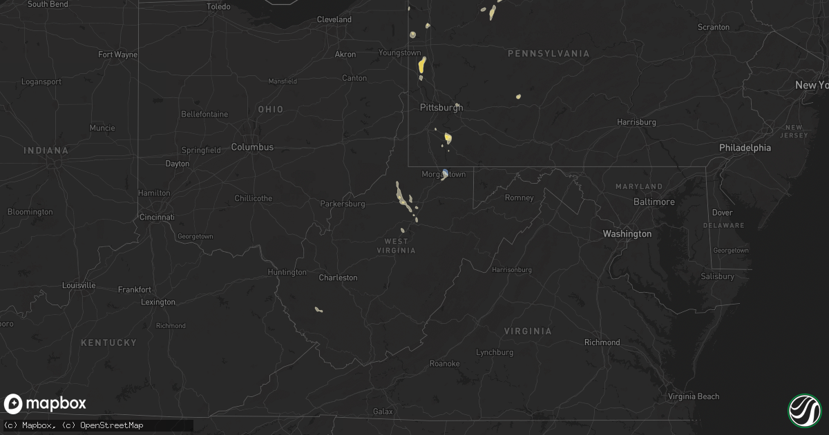
Hail Map in West Virginia on June 18, 2024
Get this storm
June 18 map
$229
one time, instant access
Download today. No call, no setup
Keep the $229
Bought the map and want the full workflow? Apply the entire $229 to a subscription within 7 days. None of it is wasted.
Every map, not just this one
This buys you this map. Subscription and you get every map we run, in the markets you choose from a few cities to whole states to nationwide. Plus real-time alerts the moment a storm fires.
Contact data
Name, contact info, occupancy, even credit band for addresses in the footprint. You go from where it hit to who to call.
Become the source they trust
Unlimited branding weather history reports on demand. You already have the documented answer ready for the property owner, and you are the one who showed up with it.
Property data and RoofTrace estimates
Pull up any address you have got, its value and the exact code rules for that jurisdiction, straight from One Click Code. Then RoofTrace estimates the squares, pitch, and roof value, priced the way you price.
Storm reports in West Virginia
West Virginia
| Date | Description |
|---|---|
| 06/18/20246:54 PM CDT | Tree and lines down on alley addition st. |
| 06/18/20246:22 PM CDT | Tree reported down obstructing rush run road. |
| 06/18/20246:14 PM CDT | Tree reported down obstructing flinderation road. |
| 06/18/20245:56 PM CDT | Tree reported down obstructing lake floyd circle. |
| 06/18/20244:54 PM CDT | Downed trees reported. |
| 06/18/20244:54 PM CDT | Downed trees reported. |
| 06/18/20244:50 PM CDT | Downed trees reported. |
| 06/18/20242:15 PM CDT | Trees down on ohio avenue |
| 06/18/20242:12 PM CDT | Multiple trees down on river road |
| 06/18/20242:12 PM CDT | Trees down at intersection of richwood avenue and fortney street |
| 06/18/20242:03 PM CDT | Wires down on earl l core road near county schools administrative office. |
| 06/18/20242:02 PM CDT | Wires down on eljadid street near kfc. |
| 06/18/20242:02 PM CDT | Wires down on eljadid |
| 06/18/20242:02 PM CDT | Tree on house on eljadid street. Time estimated. |
| 06/18/20241:59 PM CDT | A local report indicates 59 MPH wind near Morgantown Airport |
| 06/18/20241:56 PM CDT | Number of trees down on brookhaven road. |
All States Impacted by Hail Map on June 18, 2024
Cities Impacted by Hail Map on June 18, 2024
- Moorcroft, WY
- Devils Tower, WY
- Hulett, WY
- Sundance, WY
- Alva, WY
- Coleharbor, ND
- Underwood, ND
- Beulah, ND
- Douglas, ND
- Garrison, ND
- Washburn, ND
- Stanton, ND
- New Salem, ND
- Riverdale, ND
- Hazen, ND
- Max, ND
- Center, ND
- Benedict, ND
- Echo, MN
- Sacred Heart, MN
- Granite Falls, MN
- Starbuck, MN
- Benson, MN
- Glenwood, MN
- Lowry, MN
- Scenic, SD
- New Underwood, SD
- Wall, SD
- Wasta, SD
- Quinn, SD
- Hermosa, SD
- Fairburn, SD
- Crane Lake, MN
- Park Rapids, MN
- Laporte, MN
- Bovey, MN
- Grand Rapids, MN
- Wellington, OH
- Side Lake, MN
- Nashwauk, MN
- Cohasset, MN
- Lagrange, OH
- Marble, MN
- Grafton, OH
- Calumet, MN
- Pengilly, MN
- Hibbing, MN
- Hill City, MN
- Perry, OH
- Hubbard, OH
- Carrolltown, PA
- Ebensburg, PA
- Angora, MN
- Chisholm, MN
- Britt, MN
- Elmora, PA
- Nicktown, PA
- Johnstown, PA
- Cook, MN
- Cleveland, OH
- Ponsford, MN
- Heartwell, NE
- Tower, MN
- Madison, OH
- Bloomington, NE
- Geneva, OH
- Lake George, MN
- Chesterland, OH
- Morgantown, WV
- Akeley, MN
- Linesville, PA
- Kenesaw, NE
- Wood River, NE
- Franklin, NE
- Holstein, NE
- Bemidji, MN
- Upland, NE
- Palco, KS
- Ellis, KS
- Painesville, OH
- Wakeeney, KS
- Campbell, NE
- Cass Lake, MN
- Phillips, NE
- Monroeville, PA
- Pittsburgh, PA
- Murrysville, PA
- Plainville, KS
- Juniata, NE
- Chapman, NE
- Marquette, NE
- Central City, NE
- Grand Island, NE
- Jefferson, OH
- Minden, NE
- Riverton, NE
- Ashtabula, OH
- Ogallah, KS
- Kensington, KS
- Agra, KS
- Collyer, KS
- Damar, KS
- Burton, OH
- North Sioux City, SD
- Sioux City, IA
- South Sioux City, NE
- Austinburg, OH
- Stockton, KS
- Bladen, NE
- Smith Center, KS
- Kingsville, OH
- Roseland, NE
- Aurora, NE
- Middlefield, OH
- Hordville, NE
- Clarks, NE
- Athol, KS
- Grindstone, PA
- Kirwin, KS
- New Salem, PA
- Allison, PA
- Smock, PA
- Brownsville, PA
- Dighton, KS
- Polk, NE
- Hastings, NE
- Ayr, NE
- Stockdale, PA
- California, PA
- Allenport, PA
- Fayette City, PA
- Gaylord, KS
- Garden City, KS
- Healy, KS
- Elco, PA
- Roscoe, PA
- Stromsburg, NE
- Hinton, IA
- Coal Center, PA
- Perryopolis, PA
- Dakota City, NE
- Homer, NE
- Newell, PA
- Charleroi, PA
- Glenvil, NE
- Bancroft, NE
- Hampton, NE
- Silver Creek, NE
- Osceola, NE
- Columbus, NE
- Beeler, KS
- Utica, KS
- McClellandtown, PA
- Blue Hill, NE
- East Millsboro, PA
- Merrill, IA
- Cimarron, KS
- Danvers, MN
- Holloway, MN
- Hancock, MN
- Springboro, PA
- Edinboro, PA
- Inland, NE
- Inavale, NE
- Red Cloud, NE
- Shelby, NE
- Fairfield, NE
- Eighty Four, PA
- Willow Lake, SD
- Le Mars, IA
- Kingsley, IA
- Robards, KY
- Henderson, KY
- Hays, KS
- Gorham, KS
- Victoria, KS
- Hazel, SD
- Clarkson, NE
- Schuyler, NE
- Vienna, OH
- Girard, OH
- Vienna, SD
- Bryant, SD
- Clay Center, NE
- Harvard, NE
- Trumbull, NE
- West Point, NE
- Beemer, NE
- Bradshaw, NE
- Clontarf, MN
- Aldrich, MN
- Verndale, MN
- Natoma, KS
- Spottsville, KY
- Evansville, IN
- Reed, KY
- Watertown, SD
- Sutton, NE
- Lake, WV
- Petersburg, NE
- Staples, MN
- Saronville, NE
- Transfer, PA
- Sharpsville, PA
- Clark, PA
- Ingalls, KS
- Keewatin, MN
- Howells, NE
- Dodge, NE
- Sublette, KS
- Satanta, KS
- Benedict, NE
- Woodston, KS
- Brookfield, OH
- Holdrege, NE
- Alexandria, SD
- Prairie View, KS
- Howard, SD
- Emery, SD
- Castlewood, SD
- Arlington, SD
- Ramona, SD
- Niobrara, NE
- Alma, NE
- Bartlett, NE
- Ewing, NE
- Olivet, SD
- Parkston, SD
- Canova, SD
- Lake Preston, SD
- Orchard, NE
- Verdigre, NE
- Hill City, KS
- Avon, SD
- Winfred, SD
- Axtell, NE
- Riverdale, NE
- Tripp, SD
- Spencer, SD
- Ravenna, NE
- Scotia, NE
- Orleans, NE
- Ashton, NE
- Ericson, NE
- Funk, NE
- Lake Norden, SD
- Tyndall, SD
- North Loup, NE
- Kearney, NE
- Badger, SD
- Springfield, SD
- Loup City, NE
- Pleasanton, NE
- Oldham, SD
- Bellwood, NE
- Ness City, KS
- Greenville, PA
- Clarks Mills, PA
- Hadley, PA
- Albion, NE
- Deweese, NE
- Pecks Mill, WV
- Hewett, WV
- Chapmanville, WV
- Rogers, NE
- Hawley, MN
- Guide Rock, NE
- Cairo, NE
- Orlando, WV
- Snyder, NE
- Scribner, NE
- Edgar, NE
- Pierceville, KS
- Bogue, KS
- Dannebrog, NE
- Beaver Falls, PA
- Sheakleyville, PA
- Penokee, KS
- Lyons, NE
- Ransom, KS
- Weston, WV
- Walkersville, WV
- Oakland, NE
- Strandburg, SD
- Stockholm, SD
- Brownell, KS
- Gresham, NE
- Rising City, NE
- Henderson, NE
- Nelson, NE
- Lenora, KS
- Logan, KS
- Milbank, SD
- Twin Brooks, SD
- Geneva, NE
- Jane Lew, WV
- Hooper, NE
- Koppel, PA
- Ellwood City, PA
- New Brighton, PA
- Wampum, PA
- Lost Creek, WV
- Grafton, NE
- Ong, NE
- Shickley, NE
- Craig, NE
- Jetmore, KS
- Almena, KS
- Copeland, KS
- Sauk Centre, MN
- New Castle, PA
- Moscow, KS
- McCracken, KS
- Paradise, KS
- Surprise, NE
- Brooten, MN
- Bazine, KS
- Volant, PA
- Ortonville, MN
- Big Stone City, SD
- Onawa, IA
- Whiting, IA
- David City, NE
- Davenport, NE
- Phillipsburg, KS
- Long Island, KS
- Melrose, MN
- Clarksburg, WV
- Mount Clare, WV
- Strang, NE
- Ulysses, NE
- Long Prairie, MN
- Osakis, MN
- Waldo, KS
- Salem, WV
- Villard, MN
- Anthon, IA
- Oto, IA
- Hornick, IA
- Burtrum, MN
- Swanville, MN
- Hugoton, KS
- Smithland, IA
- Rodney, IA
- Castana, IA
- Correctionville, IA
- Florence, SD
- South Shore, SD
- Osborne, KS
- Luray, KS
- Grey Eagle, MN
- Montezuma, KS
- Republican City, NE
- Marienville, PA
- Barnesville, MN
- Naponee, NE
- Dodge City, KS
- Liberal, KS
- Sisseton, SD
- Danbury, IA
- Youngstown, OH
- Schoenchen, KS
- Walker, KS
- Bunker Hill, KS
- Russell, KS
- Dorrance, KS
- Battle Creek, IA
- Freeport, MN
- East Hickory, PA
- Endeavor, PA
- Sheffield, PA
- Little Falls, MN
- West Union, WV
- Hildreth, NE
- Plains, KS
- Mankato, KS
- Britton, SD
- Alexander, KS
- Ellicottville, NY
- Great Valley, NY
- Wilcox, NE
- Linn Grove, IA
- Formoso, KS
- Tionesta, PA
- Wallace, WV
- Webber, KS
- Kismet, KS
- Nekoma, KS
- La Crosse, KS
- Alta, IA
- Rembrandt, IA
- Center Point, WV
- Sylvan Grove, KS
- Wilson, KS
- Lucas, KS
- Lincoln, KS
- Jewell, KS
- Rush Center, KS
- Courtland, KS
- Beloit, KS
- Ensign, KS
- Jacksonburg, WV
- Reader, WV
- Pine Grove, WV
- Sioux Rapids, IA
- Council Bluffs, IA
- Tiona, PA
- Warren, PA
- Clarendon, PA
- Doniphan, NE
- Underwood, IA
- Bison, KS
- Jamestown, KS
- Norway, KS
- Crescent, IA
- Larned, KS
- Otis, KS
- Scandia, KS
- Belleville, KS
- Hoisington, KS
- Olmitz, KS
- Alda, NE
- Emmetsburg, IA
- Zimmerman, MN
- Mallard, IA
- Wright, KS
- St John, KS
- Pawnee Rock, KS
- Cuba, KS
- Agenda, KS
- Albert, KS
- Fenton, IA
- Cylinder, IA
- Great Bend, KS
- Livermore, IA
- Lu Verne, IA
- Spearville, KS
- Ringsted, IA
- Algona, IA
- Barnum, MN
- Claflin, KS
- Wesley, IA
- Gainesville, NY
- Warsaw, NY
- Offerle, KS
- Fowler, KS
- Meade, KS
- Penn Yan, NY
- Hooker, OK
- Raymond, KS
- Ellinwood, KS
- Holyrood, KS
- Chase, KS
- Bushton, KS
- Brook Park, MN
- Tyrone, OK
- Turpin, OK
- Minneola, KS
- Kinsley, KS
- Guymon, OK
- Geneseo, KS
- Ellsworth, KS
- Lyons, KS
- Marquette, KS
- Little River, KS
- Kanopolis, KS
- Lorraine, KS
- Mcpherson, KS
- Windom, KS
- Falun, KS
- Lindsborg, KS
- Salina, KS
- Brookville, KS
- Assaria, KS
- Macksville, KS
- Ovid, NY
- Lodi, NY
- Forgan, OK
- Niles, OH
- Dunlevy, PA
- Romulus, NY
- Ford, KS
- Hardesty, OK
- Beaver, OK
- Balko, OK
- Gate, OK
- Laverne, OK
- Goodwell, OK
- Rhodes, IA
- Newton, IA
- Haverhill, IA
- Conrad, IA
- Wellsburg, IA
- New Providence, IA
- Eldora, IA
- Clemons, IA
- Ackley, IA
- Union, IA
- State Center, IA
- Melbourne, IA
- Albion, IA
- Marshalltown, IA
- Mingo, IA
- Collins, IA
- Hubbard, IA
- Baxter, IA
- Laurel, IA
- Whitten, IA
- McCallsburg, IA
- Grundy Center, IA
- Steamboat Rock, IA
- Colo, IA
- Zearing, IA
- Saint Anthony, IA
- Maxwell, IA
- Nevada, IA
- Iowa Falls, IA
- Liscomb, IA
- Montour, IA
- Gladbrook, IA
- Toledo, IA
- Aplington, IA
- Ferguson, IA
- Tama, IA
- Le Grand, IA
- Garwin, IA
- Beaman, IA
- Gilman, IA
- Holland, IA
- Austinville, IA
- Hudson, IA
- Reinbeck, IA
- New Hartford, IA
- Buckingham, IA
- Parkersburg, IA
- Dike, IA
- Morrison, IA
- Waterloo, IA
- Lincoln, IA
- Traer, IA
- Shell Rock, IA
- Stout, IA
- Cedar Falls, IA
- La Porte City, IA
- Evansdale, IA
- Clutier, IA
- Dysart, IA
- Texhoma, OK
- Texhoma, TX
- Stratford, TX
- Gruver, TX
- Texline, TX
- Clayton, NM
- Dalhart, TX
- Felt, OK
- Kenton, OK
- Boise City, OK
- Campo, CO
- Dresser, WI
- Saint Croix Falls, WI


