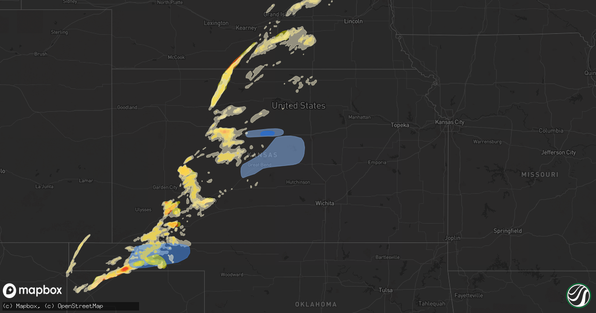
Hail Map in Kansas on June 18, 2024
Get this storm
June 18 map
$229
one time, instant access
Download today. No call, no setup
Keep the $229
Bought the map and want the full workflow? Apply the entire $229 to a subscription within 7 days. None of it is wasted.
Every map, not just this one
This buys you this map. Subscription and you get every map we run, in the markets you choose from a few cities to whole states to nationwide. Plus real-time alerts the moment a storm fires.
Contact data
Name, contact info, occupancy, even credit band for addresses in the footprint. You go from where it hit to who to call.
Become the source they trust
Unlimited branding weather history reports on demand. You already have the documented answer ready for the property owner, and you are the one who showed up with it.
Property data and RoofTrace estimates
Pull up any address you have got, its value and the exact code rules for that jurisdiction, straight from One Click Code. Then RoofTrace estimates the squares, pitch, and roof value, priced the way you price.
Storm reports in Kansas
Kansas
| Date | Description |
|---|---|
| 06/18/20246:47 PM CDT | Corrects time on previous tornado report from 1 ese ensign. A tornado crossed the county line from gray to ford. No damage reported but several sightings of the tornado |
| 06/18/20246:35 PM CDT | A local report indicates 83 MPH wind near Satanta |
| 06/18/20246:33 PM CDT | Delayed report. |
| 06/18/20246:20 PM CDT | A local report indicates 1.00 inch wind near Copeland |
| 06/18/20246:02 PM CDT | A local report indicates 78 MPH wind near 3 NE Bunker Hill |
| 06/18/20245:56 PM CDT | A local report indicates 69 MPH wind near Russell Airport |
| 06/18/20245:48 PM CDT | Relayed report from gld. Time estimated from radar. |
| 06/18/20245:45 PM CDT | A local report indicates 1.00 inch wind near Sublette |
| 06/18/20245:31 PM CDT | Report from mping: quarter |
| 06/18/20245:30 PM CDT | Mping report. |
| 06/18/20245:26 PM CDT | Report from mping: quarter |
| 06/18/20245:20 PM CDT | [landspout] |
| 06/18/20245:18 PM CDT | Mostly nickels with a few quarters. |
| 06/18/20245:10 PM CDT | Hail ranged from dime to half dollar in size. |
| 06/18/20244:47 PM CDT | Lasted 3-4 minutes. |
| 06/18/20244:46 PM CDT | [landspout] |
| 06/18/20244:25 PM CDT | A local report indicates 1.75 inch wind near 1 SW Ellis |
| 06/18/20243:46 PM CDT | Numerous photos and video evidence of a tornado. Report of the tornado persistent for 10 mins. Rating efu due to no damage reported. |
| 06/18/20243:45 PM CDT | A local report indicates 2.00 inch wind near Ellis |
| 06/18/20243:42 PM CDT | A local report indicates 1.50 inch wind near 1 S Riga |
| 06/18/20243:42 PM CDT | A local report indicates 1.75 inch wind near Ellis |
| 06/18/20243:02 PM CDT | [landspout] |
| 06/17/202410:06 PM CDT | Estimated 60mph with 3-4 inch limbs down. |
| 06/17/20248:40 PM CDT | Lots of dust getting kicked up into the air as well. Delayed report. Time estimated by radar. |
| 06/17/20248:35 PM CDT | A local report indicates 70 MPH wind near 2 NE Kanopolis |
| 06/17/20248:30 PM CDT | A local report indicates 1.00 inch wind near Liberal |
| 06/17/20248:25 PM CDT | A local report indicates 1.00 inch wind near Liberal |
| 06/17/20248:10 PM CDT | Strong winds making for difficult driving conditions. Winds estimated around 60 mph. |
| 06/17/20248:09 PM CDT | Estimated 55-60 mph. |
| 06/17/20247:50 PM CDT | A local report indicates 74 MPH wind near 1 S Claflin |
| 06/17/20247:47 PM CDT | A tornado crossed the county line from gray to ford. No damage reported but several sightings of the tornado and photo evidence. Tornado estimated efu. Time is radar es |
| 06/17/20247:35 PM CDT | Estimated 50 to 60 mph wind gusts west of great bend. |
| 06/17/20247:31 PM CDT | A local report indicates 63 MPH wind near 2 E Pawnee Rock |
| 06/17/20247:25 PM CDT | A local report indicates 1.00 inch wind near 2 NW Ft. Dodge |
| 06/17/20247:20 PM CDT | A local report indicates 1.00 inch wind near 1 SE Dodge City |
| 06/17/20247:20 PM CDT | A local report indicates 1.50 inch wind near 2 SSW Dodge City |
| 06/17/20247:00 PM CDT | A local report indicates 1.75 inch wind near 7 WNW Plains City |
All States Impacted by Hail Map on June 18, 2024
Cities Impacted by Hail Map on June 18, 2024
- Moorcroft, WY
- Devils Tower, WY
- Hulett, WY
- Sundance, WY
- Alva, WY
- Coleharbor, ND
- Underwood, ND
- Beulah, ND
- Douglas, ND
- Garrison, ND
- Washburn, ND
- Stanton, ND
- New Salem, ND
- Riverdale, ND
- Hazen, ND
- Max, ND
- Center, ND
- Benedict, ND
- Echo, MN
- Sacred Heart, MN
- Granite Falls, MN
- Starbuck, MN
- Benson, MN
- Glenwood, MN
- Lowry, MN
- Scenic, SD
- New Underwood, SD
- Wall, SD
- Wasta, SD
- Quinn, SD
- Hermosa, SD
- Fairburn, SD
- Crane Lake, MN
- Park Rapids, MN
- Laporte, MN
- Bovey, MN
- Grand Rapids, MN
- Wellington, OH
- Side Lake, MN
- Nashwauk, MN
- Cohasset, MN
- Lagrange, OH
- Marble, MN
- Grafton, OH
- Calumet, MN
- Pengilly, MN
- Hibbing, MN
- Hill City, MN
- Perry, OH
- Hubbard, OH
- Carrolltown, PA
- Ebensburg, PA
- Angora, MN
- Chisholm, MN
- Britt, MN
- Elmora, PA
- Nicktown, PA
- Johnstown, PA
- Cook, MN
- Cleveland, OH
- Ponsford, MN
- Heartwell, NE
- Tower, MN
- Madison, OH
- Bloomington, NE
- Geneva, OH
- Lake George, MN
- Chesterland, OH
- Morgantown, WV
- Akeley, MN
- Linesville, PA
- Kenesaw, NE
- Wood River, NE
- Franklin, NE
- Holstein, NE
- Bemidji, MN
- Upland, NE
- Palco, KS
- Ellis, KS
- Painesville, OH
- Wakeeney, KS
- Campbell, NE
- Cass Lake, MN
- Phillips, NE
- Monroeville, PA
- Pittsburgh, PA
- Murrysville, PA
- Plainville, KS
- Juniata, NE
- Chapman, NE
- Marquette, NE
- Central City, NE
- Grand Island, NE
- Jefferson, OH
- Minden, NE
- Riverton, NE
- Ashtabula, OH
- Ogallah, KS
- Kensington, KS
- Agra, KS
- Collyer, KS
- Damar, KS
- Burton, OH
- North Sioux City, SD
- Sioux City, IA
- South Sioux City, NE
- Austinburg, OH
- Stockton, KS
- Bladen, NE
- Smith Center, KS
- Kingsville, OH
- Roseland, NE
- Aurora, NE
- Middlefield, OH
- Hordville, NE
- Clarks, NE
- Athol, KS
- Grindstone, PA
- Kirwin, KS
- New Salem, PA
- Allison, PA
- Smock, PA
- Brownsville, PA
- Dighton, KS
- Polk, NE
- Hastings, NE
- Ayr, NE
- Stockdale, PA
- California, PA
- Allenport, PA
- Fayette City, PA
- Gaylord, KS
- Garden City, KS
- Healy, KS
- Elco, PA
- Roscoe, PA
- Stromsburg, NE
- Hinton, IA
- Coal Center, PA
- Perryopolis, PA
- Dakota City, NE
- Homer, NE
- Newell, PA
- Charleroi, PA
- Glenvil, NE
- Bancroft, NE
- Hampton, NE
- Silver Creek, NE
- Osceola, NE
- Columbus, NE
- Beeler, KS
- Utica, KS
- McClellandtown, PA
- Blue Hill, NE
- East Millsboro, PA
- Merrill, IA
- Cimarron, KS
- Danvers, MN
- Holloway, MN
- Hancock, MN
- Springboro, PA
- Edinboro, PA
- Inland, NE
- Inavale, NE
- Red Cloud, NE
- Shelby, NE
- Fairfield, NE
- Eighty Four, PA
- Willow Lake, SD
- Le Mars, IA
- Kingsley, IA
- Robards, KY
- Henderson, KY
- Hays, KS
- Gorham, KS
- Victoria, KS
- Hazel, SD
- Clarkson, NE
- Schuyler, NE
- Vienna, OH
- Girard, OH
- Vienna, SD
- Bryant, SD
- Clay Center, NE
- Harvard, NE
- Trumbull, NE
- West Point, NE
- Beemer, NE
- Bradshaw, NE
- Clontarf, MN
- Aldrich, MN
- Verndale, MN
- Natoma, KS
- Spottsville, KY
- Evansville, IN
- Reed, KY
- Watertown, SD
- Sutton, NE
- Lake, WV
- Petersburg, NE
- Staples, MN
- Saronville, NE
- Transfer, PA
- Sharpsville, PA
- Clark, PA
- Ingalls, KS
- Keewatin, MN
- Howells, NE
- Dodge, NE
- Sublette, KS
- Satanta, KS
- Benedict, NE
- Woodston, KS
- Brookfield, OH
- Holdrege, NE
- Alexandria, SD
- Prairie View, KS
- Howard, SD
- Emery, SD
- Castlewood, SD
- Arlington, SD
- Ramona, SD
- Niobrara, NE
- Alma, NE
- Bartlett, NE
- Ewing, NE
- Olivet, SD
- Parkston, SD
- Canova, SD
- Lake Preston, SD
- Orchard, NE
- Verdigre, NE
- Hill City, KS
- Avon, SD
- Winfred, SD
- Axtell, NE
- Riverdale, NE
- Tripp, SD
- Spencer, SD
- Ravenna, NE
- Scotia, NE
- Orleans, NE
- Ashton, NE
- Ericson, NE
- Funk, NE
- Lake Norden, SD
- Tyndall, SD
- North Loup, NE
- Kearney, NE
- Badger, SD
- Springfield, SD
- Loup City, NE
- Pleasanton, NE
- Oldham, SD
- Bellwood, NE
- Ness City, KS
- Greenville, PA
- Clarks Mills, PA
- Hadley, PA
- Albion, NE
- Deweese, NE
- Pecks Mill, WV
- Hewett, WV
- Chapmanville, WV
- Rogers, NE
- Hawley, MN
- Guide Rock, NE
- Cairo, NE
- Orlando, WV
- Snyder, NE
- Scribner, NE
- Edgar, NE
- Pierceville, KS
- Bogue, KS
- Dannebrog, NE
- Beaver Falls, PA
- Sheakleyville, PA
- Penokee, KS
- Lyons, NE
- Ransom, KS
- Weston, WV
- Walkersville, WV
- Oakland, NE
- Strandburg, SD
- Stockholm, SD
- Brownell, KS
- Gresham, NE
- Rising City, NE
- Henderson, NE
- Nelson, NE
- Lenora, KS
- Logan, KS
- Milbank, SD
- Twin Brooks, SD
- Geneva, NE
- Jane Lew, WV
- Hooper, NE
- Koppel, PA
- Ellwood City, PA
- New Brighton, PA
- Wampum, PA
- Lost Creek, WV
- Grafton, NE
- Ong, NE
- Shickley, NE
- Craig, NE
- Jetmore, KS
- Almena, KS
- Copeland, KS
- Sauk Centre, MN
- New Castle, PA
- Moscow, KS
- McCracken, KS
- Paradise, KS
- Surprise, NE
- Brooten, MN
- Bazine, KS
- Volant, PA
- Ortonville, MN
- Big Stone City, SD
- Onawa, IA
- Whiting, IA
- David City, NE
- Davenport, NE
- Phillipsburg, KS
- Long Island, KS
- Melrose, MN
- Clarksburg, WV
- Mount Clare, WV
- Strang, NE
- Ulysses, NE
- Long Prairie, MN
- Osakis, MN
- Waldo, KS
- Salem, WV
- Villard, MN
- Anthon, IA
- Oto, IA
- Hornick, IA
- Burtrum, MN
- Swanville, MN
- Hugoton, KS
- Smithland, IA
- Rodney, IA
- Castana, IA
- Correctionville, IA
- Florence, SD
- South Shore, SD
- Osborne, KS
- Luray, KS
- Grey Eagle, MN
- Montezuma, KS
- Republican City, NE
- Marienville, PA
- Barnesville, MN
- Naponee, NE
- Dodge City, KS
- Liberal, KS
- Sisseton, SD
- Danbury, IA
- Youngstown, OH
- Schoenchen, KS
- Walker, KS
- Bunker Hill, KS
- Russell, KS
- Dorrance, KS
- Battle Creek, IA
- Freeport, MN
- East Hickory, PA
- Endeavor, PA
- Sheffield, PA
- Little Falls, MN
- West Union, WV
- Hildreth, NE
- Plains, KS
- Mankato, KS
- Britton, SD
- Alexander, KS
- Ellicottville, NY
- Great Valley, NY
- Wilcox, NE
- Linn Grove, IA
- Formoso, KS
- Tionesta, PA
- Wallace, WV
- Webber, KS
- Kismet, KS
- Nekoma, KS
- La Crosse, KS
- Alta, IA
- Rembrandt, IA
- Center Point, WV
- Sylvan Grove, KS
- Wilson, KS
- Lucas, KS
- Lincoln, KS
- Jewell, KS
- Rush Center, KS
- Courtland, KS
- Beloit, KS
- Ensign, KS
- Jacksonburg, WV
- Reader, WV
- Pine Grove, WV
- Sioux Rapids, IA
- Council Bluffs, IA
- Tiona, PA
- Warren, PA
- Clarendon, PA
- Doniphan, NE
- Underwood, IA
- Bison, KS
- Jamestown, KS
- Norway, KS
- Crescent, IA
- Larned, KS
- Otis, KS
- Scandia, KS
- Belleville, KS
- Hoisington, KS
- Olmitz, KS
- Alda, NE
- Emmetsburg, IA
- Zimmerman, MN
- Mallard, IA
- Wright, KS
- St John, KS
- Pawnee Rock, KS
- Cuba, KS
- Agenda, KS
- Albert, KS
- Fenton, IA
- Cylinder, IA
- Great Bend, KS
- Livermore, IA
- Lu Verne, IA
- Spearville, KS
- Ringsted, IA
- Algona, IA
- Barnum, MN
- Claflin, KS
- Wesley, IA
- Gainesville, NY
- Warsaw, NY
- Offerle, KS
- Fowler, KS
- Meade, KS
- Penn Yan, NY
- Hooker, OK
- Raymond, KS
- Ellinwood, KS
- Holyrood, KS
- Chase, KS
- Bushton, KS
- Brook Park, MN
- Tyrone, OK
- Turpin, OK
- Minneola, KS
- Kinsley, KS
- Guymon, OK
- Geneseo, KS
- Ellsworth, KS
- Lyons, KS
- Marquette, KS
- Little River, KS
- Kanopolis, KS
- Lorraine, KS
- Mcpherson, KS
- Windom, KS
- Falun, KS
- Lindsborg, KS
- Salina, KS
- Brookville, KS
- Assaria, KS
- Macksville, KS
- Ovid, NY
- Lodi, NY
- Forgan, OK
- Niles, OH
- Dunlevy, PA
- Romulus, NY
- Ford, KS
- Hardesty, OK
- Beaver, OK
- Balko, OK
- Gate, OK
- Laverne, OK
- Goodwell, OK
- Rhodes, IA
- Newton, IA
- Haverhill, IA
- Conrad, IA
- Wellsburg, IA
- New Providence, IA
- Eldora, IA
- Clemons, IA
- Ackley, IA
- Union, IA
- State Center, IA
- Melbourne, IA
- Albion, IA
- Marshalltown, IA
- Mingo, IA
- Collins, IA
- Hubbard, IA
- Baxter, IA
- Laurel, IA
- Whitten, IA
- McCallsburg, IA
- Grundy Center, IA
- Steamboat Rock, IA
- Colo, IA
- Zearing, IA
- Saint Anthony, IA
- Maxwell, IA
- Nevada, IA
- Iowa Falls, IA
- Liscomb, IA
- Montour, IA
- Gladbrook, IA
- Toledo, IA
- Aplington, IA
- Ferguson, IA
- Tama, IA
- Le Grand, IA
- Garwin, IA
- Beaman, IA
- Gilman, IA
- Holland, IA
- Austinville, IA
- Hudson, IA
- Reinbeck, IA
- New Hartford, IA
- Buckingham, IA
- Parkersburg, IA
- Dike, IA
- Morrison, IA
- Waterloo, IA
- Lincoln, IA
- Traer, IA
- Shell Rock, IA
- Stout, IA
- Cedar Falls, IA
- La Porte City, IA
- Evansdale, IA
- Clutier, IA
- Dysart, IA
- Texhoma, OK
- Texhoma, TX
- Stratford, TX
- Gruver, TX
- Texline, TX
- Clayton, NM
- Dalhart, TX
- Felt, OK
- Kenton, OK
- Boise City, OK
- Campo, CO
- Dresser, WI
- Saint Croix Falls, WI


