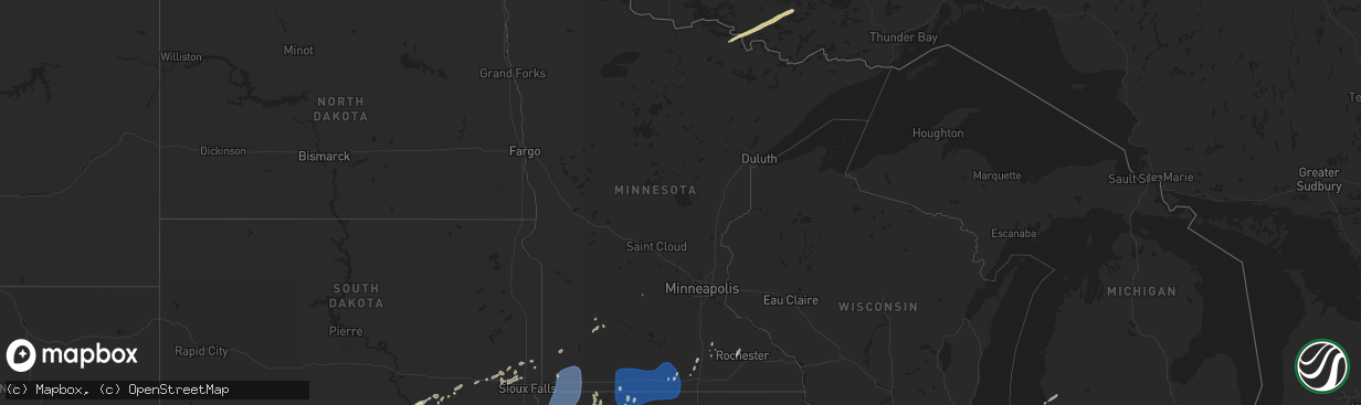
Hail Map in Minnesota on June 16, 2024
The weather event in Minnesota on June 16, 2024 includes Wind and Hail maps. 23 states and 530 cities were impacted and suffered possible damage. The total estimated number of properties impacted is 0.
Want more than just the map?
Turn this storm into a full workflow.
- Owner + property data so you know who to knock
- OnDemand branded weather history reports to win the "did we even have hail?" argument
- RoofTrace estimate so reps stop guessing numbers at the door
Bought this map? Upgrade within 7 days and we'll credit the $230. (10-15 min setup call)
Wind
Hail
0
Estimated number of impacted properties by a 1.00" hail or larger0
Estimated number of impacted properties by a 1.75" hail or larger0
Estimated number of impacted properties by a 2.50" hail or largerStorm reports in Minnesota
Minnesota
| Date | Description |
|---|---|
| 06/16/20246:42 AM CDT | Large tree snapped at base. |
| 06/16/20246:35 AM CDT | Awos station k9mn mayo helipad. |
| 06/16/20246:30 AM CDT | Tree fell on powerline as well. |
| 06/16/20246:25 AM CDT | Reported several large tree limbs and full trees down. |
| 06/16/20246:10 AM CDT | Awos station ktob dodge center airport. |
| 06/16/20244:45 AM CDT | Mesonet station mn152 t.h.30 - mapleton - mp 146.8. |
| 06/16/20244:15 AM CDT | Mesonet station mn148 i-90 - welcome - mp 93.7. |
| 06/16/20244:03 AM CDT | Awos station kfrm fairmont ap. |
| 06/16/20244:01 AM CDT | Large tree down. Time estimated via radar & report. |
| 06/16/20243:55 AM CDT | Mesonet station mn148 i-90 - welcome - mp 93.7. |
| 06/16/20243:36 AM CDT | A local report indicates 63 MPH wind near 7 WNW Trimont |
| 06/16/20242:50 AM CDT | Delayed report from monday morning storms. Social media report with video of multiple trees damaged. Branch size varied... But there were several branches estimated 6-8 |
| 06/16/20242:45 AM CDT | Delayed entry for the storms sunday night june 16 through monday morning june 17. Social media report with pictures of damage to a cattle feeder and a dented grain bin. |
| 06/16/20242:25 AM CDT | Mesonet station mn007 i-90 - rushmore - mp 35. |
All States Impacted by Hail Map on June 16, 2024
Cities Impacted by Hail Map on June 16, 2024
- Woodrow, CO
- Lindon, CO
- Anton, CO
- Brush, CO
- Akron, CO
- Cope, CO
- Otis, CO
- Yuma, CO
- Martin, SD
- Long Valley, SD
- Parmelee, SD
- Norris, SD
- White River, SD
- Okaton, SD
- Murdo, SD
- Saint Francis, SD
- Junction City, KS
- Dwight, KS
- Manhattan, KS
- Alta Vista, KS
- Burdick, KS
- Gotebo, OK
- Herington, KS
- Mountain View, OK
- Council Grove, KS
- Cordell, OK
- Peabody, KS
- Florence, KS
- Wilsey, KS
- Galva, KS
- Canton, KS
- Saint George, KS
- Rector, AR
- Whitehall, MI
- Muskegon, MI
- Holton, MI
- Twin Lake, MI
- Murphy, NC
- Oakville, IA
- Keithsburg, IL
- Joy, IL
- New Boston, IL
- Aledo, IL
- Kennett, MO
- Seaton, IL
- Blue Grass, IA
- Reynolds, IL
- Stockton, IA
- Fruitland, IA
- Taylor Ridge, IL
- Atalissa, IA
- Buffalo, IA
- Andalusia, IL
- Illinois City, IL
- Durant, IA
- Alexis, IL
- Wilton, IA
- New Liberty, IA
- Little York, IL
- Muscatine, IA
- Montpelier, IA
- Moscow, IA
- Dixon, IA
- Walcott, IA
- Galesburg, IL
- Moline, IL
- Davenport, IA
- Rock Island, IL
- Milan, IL
- New Windsor, IL
- Viola, IL
- Cambridge, IL
- Oneida, IL
- North Henderson, IL
- Woodhull, IL
- Orion, IL
- Sherrard, IL
- Alpha, IL
- Coal Valley, IL
- Galva, IL
- Wataga, IL
- Ophiem, IL
- Lynn Center, IL
- Rio, IL
- Victoria, IL
- Matherville, IL
- Altona, IL
- Gerlaw, IL
- Henderson, IL
- Monmouth, IL
- Sikeston, MO
- Andover, IL
- Eldridge, IA
- Osco, IL
- Pleasant Valley, IA
- Long Grove, IA
- Bettendorf, IA
- Le Claire, IA
- East Moline, IL
- Hampton, IL
- Geneseo, IL
- Colona, IL
- Silvis, IL
- Donahue, IA
- Port Byron, IL
- Carbon Cliff, IL
- Princeton, IA
- Rapids City, IL
- Hillsdale, IL
- Bertrand, MO
- Charleston, MO
- Jonesboro, IL
- Atkinson, IL
- Sparta, TN
- Smithville, TN
- Annawan, IL
- Kewanee, IL
- Mounds, IL
- Jennings, LA
- Sheffield, IL
- Neponset, IL
- Spencer, TN
- Anna, IL
- Toulon, IL
- Lake Arthur, LA
- Pulaski, IL
- La Fayette, IL
- Wyoming, IL
- Buda, IL
- Colquitt, GA
- Mount Morris, IL
- Richfield, KS
- Mineral, IL
- Wyanet, IL
- Princeton, IL
- Bradford, IL
- Leaf River, IL
- Tiskilwa, IL
- Crosby, MS
- Crossville, TN
- Pikeville, TN
- Byron, IL
- Winnebago, IL
- Walnut, IL
- Ohio, IL
- Prophetstown, IL
- Tampico, IL
- Crane Lake, MN
- Orr, MN
- Putnam, IL
- Rock Island, TN
- Hartsville, TN
- Lebanon, TN
- Cobden, IL
- Sulphur, LA
- Natchez, MS
- Dunlap, TN
- Castalian Springs, TN
- Clinton, MS
- Bolton, MS
- Delavan, WI
- Whitewater, WI
- Avalon, WI
- Jonesville, LA
- Elkhorn, WI
- Elkhart, KS
- Nashville, TN
- Old Hickory, TN
- Madison, TN
- Darien, WI
- Jena, LA
- Alexandria, LA
- Woodworth, LA
- Boyce, LA
- Carthage, TN
- Riddleton, TN
- Pollock, LA
- Forkland, AL
- Watertown, TN
- Smithland, KY
- Grand Rivers, KY
- Tiline, KY
- Salem, KY
- Marion, KY
- Fredonia, KY
- Eddyville, KY
- Greensboro, AL
- Sawyerville, AL
- McCook, NE
- Nara Visa, NM
- Amistad, NM
- Duncanville, AL
- Tuscaloosa, AL
- Culbertson, NE
- Perry, FL
- Salem, FL
- Marathon, TX
- Gloster, MS
- Dequincy, LA
- Manter, KS
- Rockfield, KY
- Bowling Green, KY
- Forest Hill, LA
- Glenmora, LA
- Three Oaks, MI
- New Buffalo, MI
- Union Pier, MI
- College Grove, TN
- Eagleville, TN
- Hermitage, TN
- Antioch, TN
- La Vergne, TN
- Murfreesboro, TN
- South Haven, MI
- Saint Joseph, MI
- Berrien Springs, MI
- Cairo, GA
- Thomasville, GA
- Grand Junction, MI
- Sodus, MI
- Eau Claire, MI
- Bangor, MI
- Bloomingdale, MI
- Gobles, MI
- Allegan, MI
- Paw Paw, MI
- Lawrence, MI
- Trenton, KY
- Guthrie, KY
- Wayland, MI
- Middleville, MI
- Decatur, MI
- Cassopolis, MI
- Vandalia, MI
- Hastings, MI
- Kalamazoo, MI
- Mattawan, MI
- Jones, MI
- Marcellus, MI
- Portage, MI
- Hayes Center, NE
- Oxford, NE
- Maywood, NE
- Lawton, MI
- Schoolcraft, MI
- Scotts, MI
- Galesburg, MI
- Climax, MI
- Augusta, MI
- Richland, MI
- Springview, NE
- Orleans, NE
- Alliance, NE
- Sparks, NE
- Dowagiac, MI
- Burke, SD
- Berrien Center, MI
- Alma, NE
- Battle Creek, MI
- East Leroy, MI
- Ceresco, MI
- Athens, MI
- Ellsworth, NE
- Winner, SD
- Herrick, SD
- Valentine, NE
- Colome, SD
- Gregory, SD
- Marshall, MI
- Burlington, MI
- Charlotte, MI
- Burt, MI
- Saginaw, MI
- Fairgrove, MI
- Saint Charles, MI
- Montrose, MI
- Olivet, MI
- Bridgeport, MI
- Pigeon, MI
- Ovid, MI
- Reese, MI
- Munger, MI
- Bath, MI
- Owosso, MI
- Chesaning, MI
- Dimondale, MI
- Lansing, MI
- Oakley, MI
- Eaton Rapids, MI
- East Lansing, MI
- Henderson, MI
- Laingsburg, MI
- Ashby, NE
- Platte, SD
- Hay Springs, NE
- Three Rivers, MI
- Merriman, NE
- Geddes, SD
- Corsica, SD
- Cody, NE
- Rushville, NE
- Hemingford, NE
- Kimball, NE
- Dix, NE
- Dallas, SD
- Harrison, SD
- Vicksburg, MI
- Ethan, SD
- Chappell, NE
- Crook, CO
- Mission, SD
- Mitchell, SD
- Bridgewater, SD
- Gordon, NE
- Bingham, NE
- Constantine, MI
- Sedgwick, CO
- Nenzel, NE
- Bristol, IN
- Fairfax, SD
- Bonesteel, SD
- Alexandria, SD
- Emery, SD
- Oshkosh, NE
- Crookston, NE
- Mills, NE
- Armour, SD
- Elkhart, IN
- Spencer, SD
- White Pigeon, MI
- Parkston, SD
- Dimock, SD
- Kilgore, NE
- Lewellen, NE
- Union, MI
- Whitman, NE
- Salem, SD
- Hyannis, NE
- Montrose, SD
- Centreville, MI
- Mendon, MI
- Saint Charles, SD
- Brule, NE
- Colton, SD
- Lake Andes, SD
- Chester, SD
- Hamilton, MI
- Lemoyne, NE
- Canistota, SD
- Lakeville, IN
- North Liberty, IN
- South Bend, IN
- Arthur, NE
- Holland, MI
- Dell Rapids, SD
- Colman, SD
- Ogallala, NE
- Hartford, SD
- Humboldt, SD
- Keystone, NE
- Hopkins, MI
- Egan, SD
- Trent, SD
- Mishawaka, IN
- Crooks, SD
- Baltic, SD
- Lyons, SD
- Garretson, SD
- Elsie, NE
- Wallace, NE
- Sutherland, IA
- Colon, MI
- Leonidas, MI
- Burwell, NE
- Luverne, MN
- Hartley, IA
- Everly, IA
- Royal, IA
- Royal, NE
- Paxton, NE
- Bartlett, NE
- Sturgis, MI
- Belview, MN
- Chambers, NE
- Winnetoon, NE
- Brunswick, NE
- Sutherland, NE
- Creighton, NE
- Woodstock, MN
- Lucan, MN
- North Platte, NE
- Milford, IA
- Sherwood, MI
- Oneill, NE
- Harris, IA
- Wabasso, MN
- Hershey, NE
- Redwood Falls, MN
- Lake Park, IA
- Adrian, MN
- Bigelow, MN
- Rushmore, MN
- Lismore, MN
- Worthington, MN
- Ellsworth, MN
- Kenneth, MN
- Magnolia, MN
- Round Lake, MN
- Wilmont, MN
- Reading, MN
- Iona, MN
- Fulda, MN
- Edgerton, MN
- Brewster, MN
- Sibley, IA
- Rock Rapids, IA
- George, IA
- Little Rock, IA
- Kanaranzi, MN
- Lakefield, MN
- Melvin, IA
- Ashton, IA
- Ocheyedan, IA
- Okabena, MN
- Wallingford, IA
- Graettinger, IA
- Terril, IA
- Spirit Lake, IA
- Doon, IA
- Alvord, IA
- Rock Valley, IA
- Ireton, IA
- Hull, IA
- Boyden, IA
- Matlock, IA
- Remsen, IA
- Sioux Center, IA
- Archer, IA
- Le Mars, IA
- Sheldon, IA
- Granville, IA
- Maurice, IA
- Sanborn, IA
- Hawarden, IA
- Oyens, IA
- Alton, IA
- Hospers, IA
- Orange City, IA
- Estherville, IA
- Bloomfield, NE
- Mullen, NE
- Alpha, MN
- Sherburn, MN
- Jackson, MN
- Crofton, NE
- Hutchinson, MN
- Dolliver, IA
- Armstrong, IA
- Ringsted, IA
- Thedford, NE
- Mountain Lake, MN
- Trimont, MN
- Dunnell, MN
- Odin, MN
- Neligh, NE
- Plainview, NE
- Superior, IA
- Ceylon, MN
- Ormsby, MN
- Saint James, MN
- Welcome, MN
- Fairmont, MN
- Allen, NE
- Waterbury, NE
- Newcastle, NE
- Ponca, NE
- Swea City, IA
- Fenton, IA
- Truman, MN
- Granada, MN
- Pierce, NE
- Osmond, NE
- Ledyard, IA
- Elmore, MN
- Blue Earth, MN
- Winnebago, MN
- Lakota, IA
- Buffalo Center, IA
- Delavan, MN
- Jackson, NE
- Bancroft, IA
- Thompson, IA
- Rake, IA
- Frost, MN
- Bricelyn, MN
- Wells, MN
- Scarville, IA
- Kiester, MN
- Easton, MN
- Minnesota Lake, MN
- Mapleton, MN
- Amboy, MN
- Johnstown, NE
- Atkinson, NE
- Walthill, NE
- Winnebago, NE
- West Point, NE
- Oakland, NE
- Ellendale, MN
- Elsmere, NE
- Owatonna, MN
- North Bend, NE
- Rogers, NE
- West Concord, MN
- Kenyon, MN
- Claremont, MN
- Morse Bluff, NE
- Linwood, NE
- Ewing, NE
- Byron, MN
- Rochester, MN
- Alden, MN
- Hartland, MN
- New Richland, MN
- Grand Island, NE
- Yutan, NE
- Edwardsburg, MI
- Mead, NE
- Saint Libory, NE
- Osceola, IN


