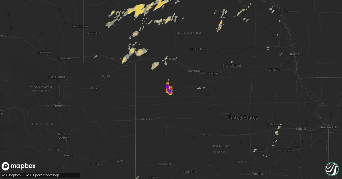
Hail Map on June 16, 2024
Get this storm
June 16 map
$229
one time, instant access
Download today. No call, no setup
Keep the $229
Bought the map and want the full workflow? Apply the entire $229 to a subscription within 7 days. None of it is wasted.
Every map, not just this one
This buys you this map. Subscription and you get every map we run, in the markets you choose from a few cities to whole states to nationwide. Plus real-time alerts the moment a storm fires.
Contact data
Name, contact info, occupancy, even credit band for addresses in the footprint. You go from where it hit to who to call.
Become the source they trust
Unlimited branding weather history reports on demand. You already have the documented answer ready for the property owner, and you are the one who showed up with it.
Property data and RoofTrace estimates
Pull up any address you have got, its value and the exact code rules for that jurisdiction, straight from One Click Code. Then RoofTrace estimates the squares, pitch, and roof value, priced the way you price.
States Impacted by Hail Map on June 16, 2024
Storm reports
Minnesota
| Date | Description |
|---|---|
| 06/16/20246:42 AM CDT | Large tree snapped at base. |
| 06/16/20246:35 AM CDT | Awos station k9mn mayo helipad. |
| 06/16/20246:30 AM CDT | Tree fell on powerline as well. |
| 06/16/20246:25 AM CDT | Reported several large tree limbs and full trees down. |
| 06/16/20246:10 AM CDT | Awos station ktob dodge center airport. |
| 06/16/20244:45 AM CDT | Mesonet station mn152 t.h.30 - mapleton - mp 146.8. |
| 06/16/20244:15 AM CDT | Mesonet station mn148 i-90 - welcome - mp 93.7. |
| 06/16/20244:03 AM CDT | Awos station kfrm fairmont ap. |
| 06/16/20244:01 AM CDT | Large tree down. Time estimated via radar & report. |
| 06/16/20243:55 AM CDT | Mesonet station mn148 i-90 - welcome - mp 93.7. |
| 06/16/20243:36 AM CDT | A local report indicates 63 MPH wind near 7 WNW Trimont |
| 06/16/20242:50 AM CDT | Delayed report from monday morning storms. Social media report with video of multiple trees damaged. Branch size varied... But there were several branches estimated 6-8 |
| 06/16/20242:45 AM CDT | Delayed entry for the storms sunday night june 16 through monday morning june 17. Social media report with pictures of damage to a cattle feeder and a dented grain bin. |
| 06/16/20242:25 AM CDT | Mesonet station mn007 i-90 - rushmore - mp 35. |
Georgia
| Date | Description |
|---|---|
| 06/16/20246:30 PM CDT | Power line down along ramsey road. |
Nebraska
| Date | Description |
|---|---|
| 06/16/20246:31 PM CDT | Report via spotter network. |
| 06/16/20241:00 AM CDT | Pictures from public via social media reporting roof torn off of house... Multiple healthy trees broken... And windbreaks blown down. Time estimate based on radar. |
| 06/16/20241:00 AM CDT | Pictures from public via social media reporting roof torn off of house... Multiple healthy trees broken... And windbreaks blown down. Time estimate based on radar. |
| 06/16/202412:15 AM CDT | Public reports pole barn collapsed... Flag poles bent... Power pole broke... And rafters blown off. Pictures were sent via social media. |
| 06/15/202410:38 PM CDT | Raining hard now with lots of lightning. |
| 06/15/20248:51 PM CDT | Measured with calipers... Had fallen moments ago from time of report. |
| 06/15/20248:49 PM CDT | A local report indicates 1.00 inch wind near Mccook |
| 06/15/20248:48 PM CDT | 8 miles north of culbertson... Ne. Started at 8:48... Stopped at 9:01. Biggest are 3â... Smallest are 1â. |
| 06/15/20248:48 PM CDT | 8 miles north of culbertson... Ne. Started at 8:48... Stopped at 9:01. Biggest are 3”... Smallest are 1”. |
| 06/15/20248:46 PM CDT | Report via spotter network. |
| 06/15/20248:45 PM CDT | A local report indicates 2.00 inch wind near 5 W Mccook |
| 06/15/20248:42 PM CDT | Public report of golfball hail.. No picture. |
| 06/15/20248:41 PM CDT | Report via spotter network. |
| 06/15/20248:40 PM CDT | Picture compared to a baseball.. Appeared slightly smaller than baseball. |
| 06/15/20248:40 PM CDT | Hail started as pea size about 7 pm. Continued off and on until about 8:40 ending with large hail up to 3.5”. Located 4 miles south of perry grain west of mccook. |
| 06/15/20248:40 PM CDT | Hail started as pea size about 7 pm. Continued off and on until about 8:40 ending with large hail up to 3.5â. Located 4 miles south of perry grain west of mccook. |
| 06/15/20248:30 PM CDT | Pictures of numerous 2.5 to 3 inch hail... Measured with ruler. |
| 06/15/20248:23 PM CDT | Measured with ruler. |
| 06/15/20248:08 PM CDT | Quarter to ping pong ball hail 2 miles south of perry grain. |
| 06/15/20248:06 PM CDT | Chaser picture of 3.2 inch hail measured with calipers. |
| 06/15/20248:01 PM CDT | Report of quarter to golf ball size hail ongoing. |
| 06/15/20247:59 PM CDT | Hail is ongoing... Chaser measured with a caliper. |
| 06/15/20247:45 PM CDT | Hail was compared to a quarter. |
| 06/15/20247:30 PM CDT | Picture on x of hail sitting on pop can... Measured pop can and was 2 inches in diameter. |
| 06/15/20247:29 PM CDT | Picture on x of 2.25 inch hail measured with calipers. |
| 06/15/20247:23 PM CDT | Spotter network report.... Able to confirm as well with spotter live stream. |
| 06/15/20247:18 PM CDT | Spotter network report of half dollar size hail ongoing. |
| 06/15/20247:16 PM CDT | Corrects previous hail report from 6 wsw mccook. Estimated golf ball size hail from storm chaser live feed. |
| 06/15/20247:16 PM CDT | Estimated golf ball size hail from storm chaser live feed. |
| 06/15/20247:12 PM CDT | Spotter reports dime to quarter size hail ongoing.. Not a lot of it however. |
Alabama
| Date | Description |
|---|---|
| 06/16/20246:36 PM CDT | Resident along northbrook drive in northport shared photos on social media of 2 trees uprooted on their property... One crushing a wooden fence and the other damaging a |
| 06/16/20246:34 PM CDT | Photo of apparent roof damage to the pride court apartments near the university of alabama campus. Photo shared on social media by the university of alabama public safe |
| 06/16/20246:32 PM CDT | A large tree along 6th avenue near lloyd hall on the university of alabama campus fell due to strong winds... Blocking the roadway. Time estimated by radar. |
Louisiana
| Date | Description |
|---|---|
| 06/16/20244:55 PM CDT | Tree snapped half way up the trunk and fell on a trailer. |
Indiana
| Date | Description |
|---|---|
| 06/16/20241:00 AM CDT | Several small to medium sized limbs downed. Pea sized hail also reported... With heavy downpour and a wind gust around 31 mph. |
| 06/16/202412:42 AM CDT | Report of trees and powerlines down on a house. Time estimated by radar. |
| 06/16/202412:40 AM CDT | Corrects previous tstm wnd dmg report from 1 sse mishawaka. Numerous repots of trees down in mishawaka. Time estimated by radar. |
| 06/16/202412:37 AM CDT | Tree down on power line. Time estimated by radar. |
| 06/16/202412:34 AM CDT | Numerous repots of trees down in mishawaka. Time estimated by radar. |
| 06/15/202410:00 PM CDT | Large tree down across sr-4. No information on health of the tree. Report relayed via scanner at 11:35 pm edt... But damage likely occurred at 11 pm per radar estimate. |
Michigan
| Date | Description |
|---|---|
| 06/15/202411:30 PM CDT | Nickle to quarter sized hail. |
| 06/15/202411:02 PM CDT | Trees down. |
| 06/15/202410:15 PM CDT | Multiple photos of trees down across portage and southern kalamazoo area. Time estimated by radar indicated downburst and initial power outage reports. |
| 06/15/202410:00 PM CDT | Trees down with radar indicated microburst. Corroborated with consumers energy power outages. |
| 06/15/20249:55 PM CDT | Multiple reports of trees and wires down across battle creek. |
| 06/15/20249:29 PM CDT | Trees down. |
| 06/15/20249:22 PM CDT | Asos station kazo kalamazoo/bc intl airport. |
| 06/15/20249:20 PM CDT | Report from mping: 3-inch tree limbs broken; power poles broken. |
| 06/15/20249:15 PM CDT | Multiple photos of trees down across the kalamazoo and portage area. Time estimated by radar indicated downburst... Initial power outage reports... And kazo asos wind o |
| 06/15/20249:12 PM CDT | County dispatch reported trees and powerlines down across cass county resulting in numerous power outages. Time estimated by radar. |
| 06/15/20248:37 PM CDT | Damage to house. |
| 06/15/20248:20 PM CDT | *** 2 inj *** st. Joseph county mi dispatch reported that numerous trees and powerlines down in three rivers with power out. Several vehicle accidents from people runni |
| 06/15/20248:15 PM CDT | Photos of multiple trees down across keeler township. Time estimated by radar. |
| 06/15/20248:15 PM CDT | Photos of multiple trees down across keeler township. Time estimated by radar. |
| 06/15/20248:05 PM CDT | Berrien county dispatch reported trees and powerlines down across the county. Time and centralized location estimated by radar. |
North Dakota
| Date | Description |
|---|---|
| 06/15/20249:24 PM CDT | Facebook report and photos of brief large hail at campgrounds on north side of lake tschida. Time estimated based on radar. |
Wisconsin
| Date | Description |
|---|---|
| 06/16/20244:33 PM CDT | Reports of a couple trees down on powerlines near clinton. Time estimate from radar. |
| 06/16/20245:31 AM CDT | Em passed on several reports across milltown wi of tree damage. She noted that some were large/significant in size. Time estimated from radar. |
Iowa
| Date | Description |
|---|---|
| 06/16/20242:18 PM CDT | 6 to 8 inch diameter branch down at location. |
| 06/16/20242:04 PM CDT | Pine tree snapped onto house at this location. Time based on radar. |
| 06/16/20241:58 PM CDT | A local report indicates 60 MPH wind near 1 WSW Bettendorf |
| 06/16/20241:52 PM CDT | Asos station kdvn davenport arpt. |
| 06/16/20241:48 PM CDT | Large branches down across road. Powerlines were down as well due to tree limbs. |
| 06/16/20241:48 PM CDT | 12inch limb blown off of tree in backyard from earlier storm today. |
| 06/16/20244:45 AM CDT | Report via a personal weather station. |
| 06/16/20244:30 AM CDT | Several large tree limbs down in ledyard. Report via social media. |
| 06/16/20243:37 AM CDT | Updated wind gust from the estherville airport asos. |
| 06/16/20243:31 AM CDT | Measured by the asos at the estherville airport. |
| 06/16/20243:07 AM CDT | Measured by a personal weather station. |
| 06/16/20243:02 AM CDT | 4 foot diameter cottonwood tree uprooted. Time estimated based on radar. |
| 06/16/20242:59 AM CDT | Numerous trees and branches down in the city of lake park. Two cars are damaged at one residence and at least two homes have branches or trees on them. Time estimated b |
| 06/16/20242:56 AM CDT | Measured by personal weather station. |
| 06/16/20242:25 AM CDT | Mesonet station rtni4 alton. |
| 06/16/20242:25 AM CDT | Mesonet station rsyi4 sibley. |
Illinois
| Date | Description |
|---|---|
| 06/16/20245:45 PM CDT | Several trees/large branches down in chatham and burnside neighborhoods. |
| 06/16/20245:30 PM CDT | Numerous downed trees/large branches in the jefferson park and portage park neighborhoods. |
| 06/16/20245:25 PM CDT | Numerous trees and large branches down in the west humboldt park neighborhood. |
| 06/16/20245:06 PM CDT | Report of 8 inch diameter tree limb snapped. Time estimated from radar. |
| 06/16/20245:06 PM CDT | Report of 8 inch diameter tree limb snapped. T |
| 06/16/20244:47 PM CDT | Multiple reports of down power lines and power outages near the elgin... West dundee... And carpentersville areas. Time estimated from radar. |
| 06/16/20244:45 PM CDT | Trees downed. |
| 06/16/20244:38 PM CDT | Report of a large tree blocking buckeye street in elgin. Time estimated from radar. |
| 06/16/20244:38 PM CDT | Repo |
| 06/16/20244:31 PM CDT | *** 1 inj *** report that a tree fell on a child resulting in an injury. Time estimated from radar. |
| 06/16/20244:27 PM CDT | Report of trees and power lines down on circle drive in campton hills. Time estimated from radar. |
| 06/16/20244:15 PM CDT | Report of trees down blocking both lanes of traffic on west county line road at winters road in maple park. Time estimated from radar. |
| 06/16/20244:10 PM CDT | Report of a roof collapse on at the mobile g |
| 06/16/20244:10 PM CDT | Report of 5 inch diameter branch down on a home causing damage to the porch. |
| 06/16/20244:10 PM CDT | Corrects previous tstm wnd dmg report from 3 e winnebago. Report of a gas station canopy collapse on at the mobile gas station at us 20 and meridian road in rockford. |
| 06/16/20244:08 PM CDT | Ambient weather station ws2902 recorded a 58.2 mph gust associated with thunderstorm outflow. |
| 06/16/20244:04 PM CDT | Pictures received of a large tree down on the side of a home. Time estimated from radar. |
| 06/16/20244:02 PM CDT | Pictures received of numerous trees and power lines down in the parker wood subdivision. Time estimated from radar. |
| 06/16/20243:59 PM CDT | Corrects previous tstm wnd dmg report from 3 e winnebago. Mobil gas station canopy collapsed at us 20 and meridian road on the far west side of rockford. |
| 06/16/20243:56 PM CDT | Report of a 6 to 7 inch diameter tree limb down at wifr in rockford. Time estimated from radar. |
| 06/16/20243:56 PM CDT | Report of a 5 to 6 inch diameter tree limb down near north main street and auburn in rockford. |
| 06/16/20243:40 PM CDT | Media reported trees down in malden. |
| 06/16/20243:35 PM CDT | Reports of trees down in princeton. Time based on radar. |
| 06/16/20243:33 PM CDT | A local report indicates 1.00 inch wind near 3 WNW Castleton |
| 06/16/20243:30 PM CDT | Thunderstorm outflow winds downed a tree onto a car on eighth street near st. Andrews church in murphysboro. Time estimated from radar. |
| 06/16/20243:25 PM CDT | Picture of downed tree relayed to us from a viewer. |
| 06/16/20243:24 PM CDT | 6 in tree limbs down near toulon sheriffs office. |
| 06/16/20243:18 PM CDT | Time estimated by radar. |
| 06/16/20243:17 PM CDT | Tree damage reported in town. |
| 06/16/20243:16 PM CDT | A few 3-5 inch diameter tree limbs were downed in polo. Time estimated from radar. |
| 06/16/20243:15 PM CDT | Photos relayed of a few trees snapped near the base at the hidden lake country club south of sheffield. One tree branch landed on the side of a building causing damage. |
| 06/16/20243:06 PM CDT | Large branches down in town. |
| 06/16/20242:56 PM CDT | County dispatch reported tree down in lanark. Time estimated by radar. |
| 06/16/20242:55 PM CDT | Tree down across highway 146 near the intersection of highway 127. Time estimated from radar. |
| 06/16/20242:50 PM CDT | County dispatch reported tree fell on a squad car in town of chadwick. Time estimated by radar. |
| 06/16/20242:36 PM CDT | Powerlines down from storms. |
| 06/16/20242:31 PM CDT | 6 inch tree branch down by hammond-henry hospital. |
| 06/16/20241:56 PM CDT | Social media post of powerlines down closing highway 67 in both directions. |
| 06/16/20241:54 PM CDT | Corrects previous tstm wnd gst report from 1 w moline quad-city airport. Asos station kmli quad city intl arpt. |
| 06/16/20241:54 PM CDT | Corrects previous tstm wnd gst report from 1 w moline quad-city airport. Corrects previous tstm wnd gst report from 1 w moline quad-city airport. Asos station kmli quad |
| 06/16/202412:54 PM CDT | Asos station kmli quad city intl arpt. |
Tennessee
| Date | Description |
|---|---|
| 06/16/20246:12 PM CDT | Tspotter photos of a tree and a few tree limbs plus a power line down in brentwood and crieve hall areas. |
| 06/16/20243:25 PM CDT | Tspotter and facebook photos showed several trees... Tree limbs and power lines down in the north inglewood and madison areas... Including on w marathona rd... Brush hi |
Missouri
| Date | Description |
|---|---|
| 06/16/20241:48 PM CDT | Corrects previous tstm wnd dmg report from 4 ssw blodgett. Damage to the roof of a house and trees along mo 449 near old bethel baptist church. Time estimated with rada |
Ohio
| Date | Description |
|---|---|
| 06/16/20246:49 AM CDT | Report from mping. |
Cities Impacted by Hail Map on June 16, 2024
- Woodrow, CO
- Lindon, CO
- Anton, CO
- Brush, CO
- Akron, CO
- Cope, CO
- Otis, CO
- Yuma, CO
- Martin, SD
- Long Valley, SD
- Parmelee, SD
- Norris, SD
- White River, SD
- Okaton, SD
- Murdo, SD
- Saint Francis, SD
- Junction City, KS
- Dwight, KS
- Manhattan, KS
- Alta Vista, KS
- Burdick, KS
- Gotebo, OK
- Herington, KS
- Mountain View, OK
- Council Grove, KS
- Cordell, OK
- Peabody, KS
- Florence, KS
- Wilsey, KS
- Galva, KS
- Canton, KS
- Saint George, KS
- Rector, AR
- Whitehall, MI
- Muskegon, MI
- Holton, MI
- Twin Lake, MI
- Murphy, NC
- Oakville, IA
- Keithsburg, IL
- Joy, IL
- New Boston, IL
- Aledo, IL
- Kennett, MO
- Seaton, IL
- Blue Grass, IA
- Reynolds, IL
- Stockton, IA
- Fruitland, IA
- Taylor Ridge, IL
- Atalissa, IA
- Buffalo, IA
- Andalusia, IL
- Illinois City, IL
- Durant, IA
- Alexis, IL
- Wilton, IA
- New Liberty, IA
- Little York, IL
- Muscatine, IA
- Montpelier, IA
- Moscow, IA
- Dixon, IA
- Walcott, IA
- Galesburg, IL
- Moline, IL
- Davenport, IA
- Rock Island, IL
- Milan, IL
- New Windsor, IL
- Viola, IL
- Cambridge, IL
- Oneida, IL
- North Henderson, IL
- Woodhull, IL
- Orion, IL
- Sherrard, IL
- Alpha, IL
- Coal Valley, IL
- Galva, IL
- Wataga, IL
- Ophiem, IL
- Lynn Center, IL
- Rio, IL
- Victoria, IL
- Matherville, IL
- Altona, IL
- Gerlaw, IL
- Henderson, IL
- Monmouth, IL
- Sikeston, MO
- Andover, IL
- Eldridge, IA
- Osco, IL
- Pleasant Valley, IA
- Long Grove, IA
- Bettendorf, IA
- Le Claire, IA
- East Moline, IL
- Hampton, IL
- Geneseo, IL
- Colona, IL
- Silvis, IL
- Donahue, IA
- Port Byron, IL
- Carbon Cliff, IL
- Princeton, IA
- Rapids City, IL
- Hillsdale, IL
- Bertrand, MO
- Charleston, MO
- Jonesboro, IL
- Atkinson, IL
- Sparta, TN
- Smithville, TN
- Annawan, IL
- Kewanee, IL
- Mounds, IL
- Jennings, LA
- Sheffield, IL
- Neponset, IL
- Spencer, TN
- Anna, IL
- Toulon, IL
- Lake Arthur, LA
- Pulaski, IL
- La Fayette, IL
- Wyoming, IL
- Buda, IL
- Colquitt, GA
- Mount Morris, IL
- Richfield, KS
- Mineral, IL
- Wyanet, IL
- Princeton, IL
- Bradford, IL
- Leaf River, IL
- Tiskilwa, IL
- Crosby, MS
- Crossville, TN
- Pikeville, TN
- Byron, IL
- Winnebago, IL
- Walnut, IL
- Ohio, IL
- Prophetstown, IL
- Tampico, IL
- Crane Lake, MN
- Orr, MN
- Putnam, IL
- Rock Island, TN
- Hartsville, TN
- Lebanon, TN
- Cobden, IL
- Sulphur, LA
- Natchez, MS
- Dunlap, TN
- Castalian Springs, TN
- Clinton, MS
- Bolton, MS
- Delavan, WI
- Whitewater, WI
- Avalon, WI
- Jonesville, LA
- Elkhorn, WI
- Elkhart, KS
- Nashville, TN
- Old Hickory, TN
- Madison, TN
- Darien, WI
- Jena, LA
- Alexandria, LA
- Woodworth, LA
- Boyce, LA
- Carthage, TN
- Riddleton, TN
- Pollock, LA
- Forkland, AL
- Watertown, TN
- Smithland, KY
- Grand Rivers, KY
- Tiline, KY
- Salem, KY
- Marion, KY
- Fredonia, KY
- Eddyville, KY
- Greensboro, AL
- Sawyerville, AL
- McCook, NE
- Nara Visa, NM
- Amistad, NM
- Duncanville, AL
- Tuscaloosa, AL
- Culbertson, NE
- Perry, FL
- Salem, FL
- Marathon, TX
- Gloster, MS
- Dequincy, LA
- Manter, KS
- Rockfield, KY
- Bowling Green, KY
- Forest Hill, LA
- Glenmora, LA
- Three Oaks, MI
- New Buffalo, MI
- Union Pier, MI
- College Grove, TN
- Eagleville, TN
- Hermitage, TN
- Antioch, TN
- La Vergne, TN
- Murfreesboro, TN
- South Haven, MI
- Saint Joseph, MI
- Berrien Springs, MI
- Cairo, GA
- Thomasville, GA
- Grand Junction, MI
- Sodus, MI
- Eau Claire, MI
- Bangor, MI
- Bloomingdale, MI
- Gobles, MI
- Allegan, MI
- Paw Paw, MI
- Lawrence, MI
- Trenton, KY
- Guthrie, KY
- Wayland, MI
- Middleville, MI
- Decatur, MI
- Cassopolis, MI
- Vandalia, MI
- Hastings, MI
- Kalamazoo, MI
- Mattawan, MI
- Jones, MI
- Marcellus, MI
- Portage, MI
- Hayes Center, NE
- Oxford, NE
- Maywood, NE
- Lawton, MI
- Schoolcraft, MI
- Scotts, MI
- Galesburg, MI
- Climax, MI
- Augusta, MI
- Richland, MI
- Springview, NE
- Orleans, NE
- Alliance, NE
- Sparks, NE
- Dowagiac, MI
- Burke, SD
- Berrien Center, MI
- Alma, NE
- Battle Creek, MI
- East Leroy, MI
- Ceresco, MI
- Athens, MI
- Ellsworth, NE
- Winner, SD
- Herrick, SD
- Valentine, NE
- Colome, SD
- Gregory, SD
- Marshall, MI
- Burlington, MI
- Charlotte, MI
- Burt, MI
- Saginaw, MI
- Fairgrove, MI
- Saint Charles, MI
- Montrose, MI
- Olivet, MI
- Bridgeport, MI
- Pigeon, MI
- Ovid, MI
- Reese, MI
- Munger, MI
- Bath, MI
- Owosso, MI
- Chesaning, MI
- Dimondale, MI
- Lansing, MI
- Oakley, MI
- Eaton Rapids, MI
- East Lansing, MI
- Henderson, MI
- Laingsburg, MI
- Ashby, NE
- Platte, SD
- Hay Springs, NE
- Three Rivers, MI
- Merriman, NE
- Geddes, SD
- Corsica, SD
- Cody, NE
- Rushville, NE
- Hemingford, NE
- Kimball, NE
- Dix, NE
- Dallas, SD
- Harrison, SD
- Vicksburg, MI
- Ethan, SD
- Chappell, NE
- Crook, CO
- Mission, SD
- Mitchell, SD
- Bridgewater, SD
- Gordon, NE
- Bingham, NE
- Constantine, MI
- Sedgwick, CO
- Nenzel, NE
- Bristol, IN
- Fairfax, SD
- Bonesteel, SD
- Alexandria, SD
- Emery, SD
- Oshkosh, NE
- Crookston, NE
- Mills, NE
- Armour, SD
- Elkhart, IN
- Spencer, SD
- White Pigeon, MI
- Parkston, SD
- Dimock, SD
- Kilgore, NE
- Lewellen, NE
- Union, MI
- Whitman, NE
- Salem, SD
- Hyannis, NE
- Montrose, SD
- Centreville, MI
- Mendon, MI
- Saint Charles, SD
- Brule, NE
- Colton, SD
- Lake Andes, SD
- Chester, SD
- Hamilton, MI
- Lemoyne, NE
- Canistota, SD
- Lakeville, IN
- North Liberty, IN
- South Bend, IN
- Arthur, NE
- Holland, MI
- Dell Rapids, SD
- Colman, SD
- Ogallala, NE
- Hartford, SD
- Humboldt, SD
- Keystone, NE
- Hopkins, MI
- Egan, SD
- Trent, SD
- Mishawaka, IN
- Crooks, SD
- Baltic, SD
- Lyons, SD
- Garretson, SD
- Elsie, NE
- Wallace, NE
- Sutherland, IA
- Colon, MI
- Leonidas, MI
- Burwell, NE
- Luverne, MN
- Hartley, IA
- Everly, IA
- Royal, IA
- Royal, NE
- Paxton, NE
- Bartlett, NE
- Sturgis, MI
- Belview, MN
- Chambers, NE
- Winnetoon, NE
- Brunswick, NE
- Sutherland, NE
- Creighton, NE
- Woodstock, MN
- Lucan, MN
- North Platte, NE
- Milford, IA
- Sherwood, MI
- Oneill, NE
- Harris, IA
- Wabasso, MN
- Hershey, NE
- Redwood Falls, MN
- Lake Park, IA
- Adrian, MN
- Bigelow, MN
- Rushmore, MN
- Lismore, MN
- Worthington, MN
- Ellsworth, MN
- Kenneth, MN
- Magnolia, MN
- Round Lake, MN
- Wilmont, MN
- Reading, MN
- Iona, MN
- Fulda, MN
- Edgerton, MN
- Brewster, MN
- Sibley, IA
- Rock Rapids, IA
- George, IA
- Little Rock, IA
- Kanaranzi, MN
- Lakefield, MN
- Melvin, IA
- Ashton, IA
- Ocheyedan, IA
- Okabena, MN
- Wallingford, IA
- Graettinger, IA
- Terril, IA
- Spirit Lake, IA
- Doon, IA
- Alvord, IA
- Rock Valley, IA
- Ireton, IA
- Hull, IA
- Boyden, IA
- Matlock, IA
- Remsen, IA
- Sioux Center, IA
- Archer, IA
- Le Mars, IA
- Sheldon, IA
- Granville, IA
- Maurice, IA
- Sanborn, IA
- Hawarden, IA
- Oyens, IA
- Alton, IA
- Hospers, IA
- Orange City, IA
- Estherville, IA
- Bloomfield, NE
- Mullen, NE
- Alpha, MN
- Sherburn, MN
- Jackson, MN
- Crofton, NE
- Hutchinson, MN
- Dolliver, IA
- Armstrong, IA
- Ringsted, IA
- Thedford, NE
- Mountain Lake, MN
- Trimont, MN
- Dunnell, MN
- Odin, MN
- Neligh, NE
- Plainview, NE
- Superior, IA
- Ceylon, MN
- Ormsby, MN
- Saint James, MN
- Welcome, MN
- Fairmont, MN
- Allen, NE
- Waterbury, NE
- Newcastle, NE
- Ponca, NE
- Swea City, IA
- Fenton, IA
- Truman, MN
- Granada, MN
- Pierce, NE
- Osmond, NE
- Ledyard, IA
- Elmore, MN
- Blue Earth, MN
- Winnebago, MN
- Lakota, IA
- Buffalo Center, IA
- Delavan, MN
- Jackson, NE
- Bancroft, IA
- Thompson, IA
- Rake, IA
- Frost, MN
- Bricelyn, MN
- Wells, MN
- Scarville, IA
- Kiester, MN
- Easton, MN
- Minnesota Lake, MN
- Mapleton, MN
- Amboy, MN
- Johnstown, NE
- Atkinson, NE
- Walthill, NE
- Winnebago, NE
- West Point, NE
- Oakland, NE
- Ellendale, MN
- Elsmere, NE
- Owatonna, MN
- North Bend, NE
- Rogers, NE
- West Concord, MN
- Kenyon, MN
- Claremont, MN
- Morse Bluff, NE
- Linwood, NE
- Ewing, NE
- Byron, MN
- Rochester, MN
- Alden, MN
- Hartland, MN
- New Richland, MN
- Grand Island, NE
- Yutan, NE
- Edwardsburg, MI
- Mead, NE
- Saint Libory, NE
- Osceola, IN