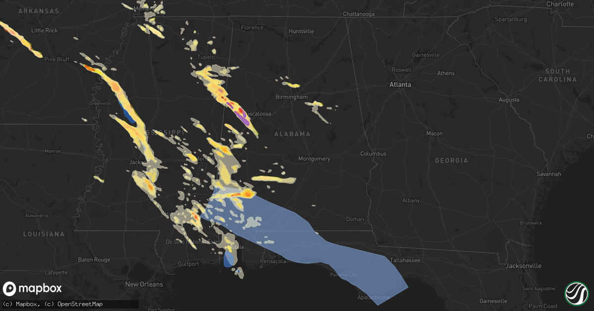
Hail Map in Alabama on June 16, 2023
Get this storm
June 16 map
$229
one time, instant access
Download today. No call, no setup
Keep the $229
Bought the map and want the full workflow? Apply the entire $229 to a subscription within 7 days. None of it is wasted.
Every map, not just this one
This buys you this map. Subscription and you get every map we run, in the markets you choose from a few cities to whole states to nationwide. Plus real-time alerts the moment a storm fires.
Contact data
Name, contact info, occupancy, even credit band for addresses in the footprint. You go from where it hit to who to call.
Become the source they trust
Unlimited branding weather history reports on demand. You already have the documented answer ready for the property owner, and you are the one who showed up with it.
Property data and RoofTrace estimates
Pull up any address you have got, its value and the exact code rules for that jurisdiction, straight from One Click Code. Then RoofTrace estimates the squares, pitch, and roof value, priced the way you price.
Storm reports in Alabama
Alabama
| Date | Description |
|---|---|
| 06/16/20236:59 PM CDT | Corrects previous tstm wnd dmg report from knoxville. Numerous trees were blown down on northbound and southbound i20/59. |
| 06/16/20236:58 PM CDT | Ema reports hen egg size hail in grove hill. Time using radar. |
| 06/16/20236:58 PM CDT | Ema reports windows blown out of a building due to wind driven hail. Time using radar. |
| 06/16/20236:56 PM CDT | Trees were blown down and blocking the roadway. |
| 06/16/20236:52 PM CDT | Large hardwood trees were blown down and blocking the roadway on speed mills road. |
| 06/16/20236:50 PM CDT | Tree down across i-20 near fosters. Time estimated by radar. |
| 06/16/20236:50 PM CDT | Numerous trees down on hwy 11... Some on houses and cars. Time estimated by radar. |
| 06/16/20236:27 PM CDT | Social media report of quarter size hail. |
| 06/16/20236:22 PM CDT | Ema reports 3 cars with busted windows and a home with busted windows from hail. Hail size estimated. |
| 06/16/20236:20 PM CDT | Social media photos and videos of dime to quarter size hail southwest of talladega. |
| 06/16/20236:18 PM CDT | A local report indicates 1.00 inch wind near 1 NE Palmerdale |
| 06/16/20236:09 PM CDT | Corrects previous hail report from 2 wnw palmerdale. Social media photos of large hail in palmerdale. |
| 06/16/20236:09 PM CDT | A local report indicates 1.00 inch wind near 2 WNW Palmerdale |
| 06/16/20236:06 PM CDT | Trees were blown down in gordo. At least one home sustained damage. |
| 06/16/20235:59 PM CDT | Hail up to golf ball size in ethelsville. |
| 06/16/20235:59 PM CDT | Corrects storm report type. Hail up to golf ball size in ethelsville. |
| 06/16/20235:50 PM CDT | Corrects previous hail report from 1 e morris. Quarter sized hail reported in morris. |
| 06/16/20235:50 PM CDT | Quarter sized hail reported in morris. |
| 06/16/20235:45 PM CDT | Hail up to quarter size. |
| 06/16/20235:40 PM CDT | Hail up to 1 to 2 inches deep covering the ground. |
| 06/16/20235:40 PM CDT | Social media photo of baseball sized hail in the coalfire area near reform. |
| 06/16/20235:26 PM CDT | Hail covering the ground. |
| 06/16/20235:26 PM CDT | Corrects previous hail report from forest. Hail covering the ground. |
| 06/16/20235:18 PM CDT | A few trees were blown down around detroit. |
| 06/16/20235:18 PM CDT | A few trees were blown down around sulligent. |
| 06/16/20235:12 PM CDT | A few trees were blown down near millport. |
| 06/16/20235:12 PM CDT | A local report indicates 1.00 inch wind near Forest |
| 06/16/20239:48 AM CDT | Several trees down in coffee county. |
| 06/16/20239:40 AM CDT | Near severe wind gusts at k0j4. |
| 06/16/20239:40 AM CDT | Several trees down in geneva county. |
| 06/16/20239:32 AM CDT | Near severe wind gusts at k79j. |
| 06/16/20239:17 AM CDT | Emergency manager relays widespread trees and powerlines down across the county. Time estimated by radar. |
| 06/16/20239:16 AM CDT | Public report with photo of a snapped pine tree on highway 84 between opp and andalusia. Time estimated by radar. |
| 06/16/20239:11 AM CDT | Report from em of tree falling onto a couple of cars. |
| 06/16/20238:45 AM CDT | Social media picture showing large tree fell on a church on sowell rd in brewte estimated from radar. |
| 06/16/20238:45 AM CDT | Social media picture showing large tree fell on a church on sowell rd in brewton al. Time using radar. |
| 06/16/20238:41 AM CDT | Uprooted tree and downed power line on douglas lane. Time estimated by radar. |
| 06/16/20238:40 AM CDT | Numerous trees and powerlines down. |
| 06/16/20238:40 AM CDT | Emergency manager reports widespread trees and powerlines down throughout the county. Time estimated by radar. |
| 06/16/20238:40 AM CDT | Numerous trees and powerlines down. |
| 06/16/20238:38 AM CDT | Social media report with photos of uprooted trees on appleton road. Time estimated by radar. |
| 06/16/20238:17 AM CDT | Public photo of multiple trees uprooted and some outbuilding structure damage. Time estimated by radar. |
| 06/16/20238:16 AM CDT | Trees down. |
| 06/16/20238:15 AM CDT | Measured wind gust by alabama a&m mesonet site located on perdido river farms between 90 to 100mph. Extensive damage also reported on the farms including multiple farm |
| 06/16/20238:00 AM CDT | An unusual anticyclonic tornado began just west of the mobile river associated with the anticyclonic bookend vortex of a powerful mesoscale convective system moving acr |
| 06/16/20238:00 AM CDT | Report of a capsized barge on the mobile river with search and rescue. Possible tornado. Time estimated by radar. |
| 06/16/20238:00 AM CDT | Corrects previous tstm wnd dmg report from 4 e bucks. Report of a capsized tugboat on the mobile river with search and rescue. Time estimated by radar. |
| 06/16/20238:00 AM CDT | Corrects previous tornado report from 3 e bucks. An unusual anticyclonic tornado began just west of the middle river associated with the anticyclonic bookend vortex of |
| 06/16/20238:00 AM CDT | Thunderstorm wind damage at this location including 2 vehicles with windows blown out... A small camper rolled... And tree down. Time estimated by radar. |
| 06/16/20237:55 AM CDT | Tree down on a residence centre st at irwin st in citronelle. Time using radar. |
| 06/16/20237:55 AM CDT | Broadcast media reports tress down with empty storage buildings flipped. Time estimated by radar. |
| 06/16/20237:52 AM CDT | Trees and power lines down. |
| 06/16/20237:50 AM CDT | Corrects previous tstm wnd gst report from 4 s barrytown. Clarke county ema estimates 60-70 mph winds near the intersection of u.s. Highway 43 and baugh rd. Numerous tr |
| 06/16/20237:50 AM CDT | Clarke county ema estimates 60-70 mph winds near the intersection of u.s. Highway 43 and baugh rd. Numerous tree limbs on the road. |
| 06/16/20237:42 AM CDT | Trees down and power outages south of dixons mills along hwy 43. |
| 06/16/20237:23 AM CDT | Emergency management reports roof damage to a building in the community of chatom. Time estimated from radar. |
| 06/16/202312:55 AM CDT | Tempest station recorded a wind gust of 53 knots. |
| 06/16/202312:28 AM CDT | Local chaser reports trees snapped... Powerlines down... And half of home roof missing du |
| 06/16/202312:28 AM CDT | Local chaser reports trees snapped... Powerlines down... And half of home roof missing due to possible tornado. |
| 06/16/202312:28 AM CDT | Local chaser reports trees snapped... Powerlines down... And half of home roof missing d |
| 06/16/202312:28 AM CDT | Local chaser reports trees snapped... Powerlines down... And half of home roof missing due to possible torn |
| 06/16/202312:14 AM CDT | Social media photo of hail ranging from nickel to quarter size about a mile east of kmob. |
| 06/16/202312:14 AM CDT | Social media photo of hail ranging from nickel to half dollar sized. Time using radar. |
| 06/15/202310:55 PM CDT | Ema reports trees down along i65 nb near mile marker 31. Time using radar. |
| 06/15/202310:36 PM CDT | Trees down across the northern portion of coffee county. |
| 06/15/202310:06 PM CDT | Numerous reports of trees down and various wind damage across pike county. |
| 06/15/20239:20 PM CDT | Several trees were blown down near highway 31 in southern lowndes county. |
| 06/15/20238:30 PM CDT | Trees were blown down around dixons mill. |
| 06/15/20238:25 PM CDT | Trees were blown down around thomaston. |
| 06/15/20238:12 PM CDT | Trees were blown down on highway 28. |
| 06/15/20238:06 PM CDT | Trees were blown down on west lafayette street and were blocking the roadway. |
| 06/15/20238:00 PM CDT | 30-40 trees were blown down around cuba. |
| 06/15/20237:59 PM CDT | Numerous trees were blown down on northbound and southbound i20/59. |
| 06/15/20237:56 PM CDT | Social media picture of quarter to half dollar size hail in camden. Time using radar. |
| 06/15/20237:50 PM CDT | A local report indicates 1.75 inch wind near 2 NE York |
| 06/15/20237:47 PM CDT | Trees were blown down on highway 63 north and were blocking the roadway. Two vehicles hit the downed trees. Unknown injuries occurred. |
| 06/15/20237:45 PM CDT | A local report indicates 1.50 inch wind near Livingston |
| 06/15/20237:43 PM CDT | Several trees down near forkland campground. |
| 06/15/20237:42 PM CDT | Several trees were blown down on dejarnett road. |
| 06/15/20237:42 PM CDT | Corrects previous tstm wnd dmg report from 3 sse dixons mill. Trees down and power outages south of dixons mills along hwy 43. |
| 06/15/20237:42 PM CDT | Several trees were blown down on dejarnett road. One landed on a vehicle and produced significant damage. |
| 06/15/20237:40 PM CDT | Trees were blown down on pearson chapel road. |
| 06/15/20237:40 PM CDT | Ping pong ball sized hail estimated at exit 8 on i-20/59. |
| 06/15/20237:36 PM CDT | Social media photo of large hail in forkland. |
| 06/15/20237:30 PM CDT | Trees and power lines were blown down north of greensboro. |
| 06/15/20237:20 PM CDT | Several trees blown down in akron. |
| 06/15/20237:17 PM CDT | Quarter size hail east of eutaw. Relayed through social media. |
| 06/15/20237:01 PM CDT | Numerous reports of quarter hail in grove hill per ema. |
All States Impacted by Hail Map on June 16, 2023
Cities Impacted by Hail Map on June 16, 2023
- Nevada, TX
- Celeste, TX
- Quinlan, TX
- Farmersville, TX
- Caddo Mills, TX
- Princeton, TX
- Greenville, TX
- Lavon, TX
- Rockwall, TX
- Terrell, TX
- Royse City, TX
- Allen, TX
- Leonard, TX
- Plano, TX
- Blue Ridge, TX
- Wylie, TX
- Mckinney, TX
- Frisco, TX
- Kaufman, TX
- Wills Point, TX
- Scroggins, TX
- Lone Oak, TX
- Klondike, TX
- Como, TX
- Dike, TX
- Quitman, TX
- Emory, TX
- Yantis, TX
- Sulphur Springs, TX
- Brashear, TX
- Pickton, TX
- Point, TX
- Alba, TX
- Wolfe City, TX
- Edgewood, TX
- Mount Pleasant, TX
- Commerce, TX
- Winfield, TX
- Campbell, TX
- Saltillo, TX
- Winnsboro, TX
- Cumby, TX
- Mount Vernon, TX
- Pecan Gap, TX
- Cooper, TX
- Talco, TX
- Ladonia, TX
- Sulphur Bluff, TX
- Lake Creek, TX
- Bogata, TX
- Deport, TX
- Collinsville, TX
- Tioga, TX
- Gainesville, TX
- Muenster, TX
- Saint Jo, TX
- Pilot Point, TX
- Celina, TX
- Sanger, TX
- Gunter, TX
- Anna, TX
- Van Alstyne, TX
- Montague, TX
- Forestburg, TX
- Rosston, TX
- Aubrey, TX
- Era, TX
- Melissa, TX
- Valley View, TX
- Prosper, TX
- Lindsay, TX
- Howe, TX
- Thackerville, OK
- Bonham, TX
- Whitewright, TX
- Bailey, TX
- Ector, TX
- Tom Bean, TX
- Savoy, TX
- Whitesboro, TX
- Sadler, TX
- Randolph, TX
- Trenton, TX
- Bells, TX
- Sherman, TX
- Little Elm, TX
- Nocona, TX
- Wilburton, OK
- Quinton, OK
- Red Oak, OK
- Richton, MS
- Waynesboro, MS
- State Line, MS
- Buckatunna, MS
- Leakesville, MS
- Millry, AL
- Silas, AL
- Neely, MS
- Chatom, AL
- Gilbertown, AL
- Wister, OK
- Talihina, OK
- Heavener, OK
- Nashoba, OK
- Frankville, AL
- Deer Park, AL
- Fruitdale, AL
- Vinegar Bend, AL
- Coffeeville, AL
- Grove Hill, AL
- Jackson, AL
- Thomasville, AL
- Whatley, AL
- Saint Stephens, AL
- Mount Vernon, AL
- Little River, AL
- Stockton, AL
- Gainestown, AL
- Leroy, AL
- Uriah, AL
- Wagarville, AL
- Sunflower, AL
- Tibbie, AL
- McIntosh, AL
- Bay Minette, AL
- Chunchula, AL
- Citronelle, AL
- Axis, AL
- Creola, AL
- McDavid, FL
- Atmore, AL
- Perdido, AL
- Moss Point, MS
- Grand Bay, AL
- Coden, AL
- Bayou La Batre, AL
- Irvington, AL
- Theodore, AL
- Mobile, AL
- Robertsdale, AL
- Milton, FL
- Cantonment, FL
- Flomaton, AL
- Century, FL
- Molino, FL
- Jay, FL
- Andalusia, AL
- Holt, FL
- Brewton, AL
- Repton, AL
- Vredenburgh, AL
- Lenox, AL
- Wing, AL
- Bagdad, FL
- Evergreen, AL
- Franklin, AL
- Frisco City, AL
- Castleberry, AL
- Range, AL
- Monroeville, AL
- Baker, FL
- Florala, AL
- Crestview, FL
- Kinston, AL
- Red Level, AL
- Lockhart, AL
- Laurel Hill, FL
- Opp, AL
- Gulf Shores, AL
- Eglin Afb, FL
- Defuniak Springs, FL
- Samson, AL
- Valparaiso, FL
- Freeport, FL
- Niceville, FL
- Ponce De Leon, FL
- Ebro, FL
- Westville, FL
- Youngstown, FL
- Chipley, FL
- Fountain, FL
- Panama City, FL
- Vernon, FL
- Panama City Beach, FL
- Alford, FL
- Bonifay, FL
- Caryville, FL
- Cottondale, FL
- Lynn Haven, FL
- Wewahitchka, FL
- Port Saint Joe, FL
- Blountstown, FL
- Clarksville, FL
- Altha, FL
- Marianna, FL
- Hurlburt Field, FL
- Fort Walton Beach, FL
- Mary Esther, FL
- Navarre, FL
- Shalimar, FL
- Miramar Beach, FL
- Santa Rosa Beach, FL
- Destin, FL
- Bristol, FL
- Hosford, FL
- Quincy, FL
- Apalachicola, FL
- Telogia, FL
- Eastpoint, FL
- Panacea, FL
- Crawfordville, FL
- Tallahassee, FL
- Sopchoppy, FL
- Lanark Village, FL
- Carrabelle, FL
- New Castle, DE
- Pennsville, NJ
- Penns Grove, NJ
- Pedricktown, NJ
- Wilmington, DE
- Elmer, NJ
- Alloway, NJ
- Bridgeton, NJ
- Woodstown, NJ
- Monroeville, NJ
- Newfield, NJ
- Pemberton, NJ
- Browns Mills, NJ
- Vincentown, NJ
- Manchester Township, NJ
- Columbus, NJ
- Jobstown, NJ
- Wrightstown, NJ
- Joint Base Mdl, NJ
- Cookstown, NJ
- Chesterfield, NJ
- New Egypt, NJ
- Lakehurst, NJ
- Gloucester, VA
- Bethel, OK
- Wilmer, AL
- Semmes, AL
- Salem, NJ
- Smithville, OK
- McLain, MS
- Beaumont, MS
- Peach Bottom, PA
- Gore, OK
- Bear, DE
- Newark, DE
- Ellendale, DE
- Milford, DE
- Milton, DE
- Lincoln, DE
- Greenwood, DE
- Whiteford, MD
- Swedesboro, NJ
- Lucedale, MS
- Perkinston, MS
- Mena, AR
- Whitesboro, OK
- Clifton Forge, VA
- Broken Bow, OK
- Gibbstown, NJ
- Bridgeport, NJ
- Middletown, DE
- Williamstown, NJ
- Franklinville, NJ
- Darlington, MD
- Street, MD
- Drumore, PA
- Delta, PA
- Vandervoort, AR
- Cove, AR
- Watson, OK
- Hatfield, AR
- Dauphin Island, AL
- Conowingo, MD
- Airville, PA
- Lincoln University, PA
- Oxford, PA
- Cochranville, PA
- Eight Mile, AL
- Dozier, AL
- Nottingham, PA
- West Grove, PA
- Coatesville, PA
- Kennett Square, PA
- Kirkwood, PA
- Avondale, PA
- Quarryville, PA
- Toughkenamon, PA
- Rising Sun, MD
- Delaware City, DE
- Vineland, NJ
- Malaga, NJ
- Suffolk, VA
- Chesapeake, VA
- Portsmouth, VA
- Moseley, VA
- Midlothian, VA
- North, VA
- Chesterfield, VA
- Norfolk, VA
- Glasgow, VA
- Natural Bridge Station, VA
- Buena Vista, VA
- Lexington, VA
- Monroe, VA
- Richmond, VA
- Tyronza, AR
- Marked Tree, AR
- Petersburg, VA
- Colonial Heights, VA
- Chester, VA
- Plainview, AR
- Buckingham, VA
- Wingina, VA
- Dillwyn, VA
- Prince George, VA
- Farmville, VA
- Meherrin, VA
- Keysville, VA
- Jessieville, AR
- Fort Lee, VA
- Disputanta, VA
- Hopewell, VA
- Hot Springs Village, AR
- Green Bay, VA
- Burkeville, VA
- Lonsdale, AR
- Crewe, VA
- Victoria, VA
- Cumberland, VA
- South Boston, VA
- Halifax, VA
- Virgilina, VA
- Nelson, VA
- Buffalo Junction, VA
- Danville, VA
- Pelham, NC
- Blanch, NC
- Providence, NC
- Yanceyville, NC
- Hot Springs National Park, AR
- Benton, AR
- Semora, NC
- Leasburg, NC
- Powhatan, VA
- Amelia Court House, VA
- Rice, VA
- Jetersville, VA
- Blackstone, VA
- Malvern, AR
- Kenbridge, VA
- Spring Grove, VA
- Charles City, VA
- Winchester, VA
- Clear Brook, VA
- Stephenson, VA
- Berryville, VA
- Summit Point, WV
- Traskwood, AR
- Charles Town, WV
- Bluemont, VA
- Round Hill, VA
- Harpers Ferry, WV
- Clarksville, VA
- Church Road, VA
- Purcellville, VA
- Poyen, AR
- Prattsville, AR
- Memphis, TN
- Olive Branch, MS
- Southaven, MS
- Sheridan, AR
- Stevensburg, VA
- Elkwood, VA
- Locust Grove, VA
- Fredericksburg, VA
- Spotsylvania, VA
- Richardsville, VA
- Lignum, VA
- Sumerduck, VA
- Grapevine, AR
- Ramah, CO
- Simla, CO
- Carrollton, VA
- Agate, CO
- Limon, CO
- Fort Eustis, VA
- Newport News, VA
- Hernando, MS
- Coldwater, MS
- Aberdeen, MS
- Hamilton, MS
- New Albany, MS
- Blue Springs, MS
- Clifton, VA
- Fairfax, VA
- Centreville, VA
- Matheson, CO
- Columbus, MS
- Woodford, VA
- Caledonia, MS
- Holly Springs, MS
- Smithfield, VA
- Fort Monroe, VA
- Hampton, VA
- Senatobia, MS
- Virginia Beach, VA
- Hornersville, MO
- Arbyrd, MO
- Hugo, CO
- Genoa, CO
- Port Royal, VA
- Palmyra, VA
- Colorado Springs, CO
- Usaf Academy, CO
- Monument, CO
- Palmer Lake, CO
- Larkspur, CO
- New Augusta, MS
- Woodbridge, VA
- Steens, MS
- Fowler, CO
- Lorton, VA
- Indian Head, MD
- Fork Union, VA
- Columbia, VA
- Okolona, MS
- Houston, MS
- Amherst, NE
- Marbury, MD
- La Plata, MD
- Ethelsville, AL
- Millport, AL
- Primrose, NE
- Reform, AL
- Albion, NE
- Arriba, CO
- Model, CO
- Rocky Ford, CO
- Pomfret, MD
- Port Tobacco, MD
- Bel Alton, MD
- Champlain, VA
- Hustle, VA
- Flagler, CO
- Pueblo, CO
- La Junta, CO
- Warrior, AL
- Gardendale, AL
- Fredericksburg, TX
- Morris, AL
- Kimberly, AL
- Alpine, AL
- Talladega, AL
- Carrollton, AL
- Boone, CO
- Newman Grove, NE
- Pinson, AL
- Newellton, LA
- Port Gibson, MS
- Tappahannock, VA
- Turrell, AR
- Nettleton, MS
- Amory, MS
- Garrison, MO
- Mammoth Spring, AR
- Spalding, NE
- Ash Flat, AR
- Rogersville, MO
- Strafford, MO
- Lake George, CO
- Greeley, NE
- Lakeland, FL
- Smyrna, DE
- Byhalia, MS
- Charlottesville, VA
- Scottsville, VA
- Booneville, MS
- Baldwyn, MS
- Amherst, VA
- Holdrege, NE
- Bealeton, VA
- Goldvein, VA
- Hardy, AR
- Viola, AR
- Hamilton, AL
- Detroit, AL
- Beaverton, AL
- Sulligent, AL
- Blue Mountain, MS
- Ripley, MS
- Cordova, TN
- Manassas, VA
- Loomis, NE
- Ecru, MS
- Proctor, AR
- Kearney, NE
- Surry, VA
- Greenwood Springs, MS
- Smithville, MS
- Rockbridge Baths, VA
- Waverly, VA
- Roseland, VA
- Gladstone, VA
- Ashland, MS
- Bartlett, NE
- Ericson, NE
- Trumann, AR
- Paron, AR
- Sutherland, VA
- Natural Bridge, VA
- Mantachie, MS
- Tupelo, MS
- Guntown, MS
- Saltillo, MS
- Eads, TN
- Arlington, TN
- Germantown, TN
- Fayetteville, NC
- Bunnell, FL
- Elberon, VA
- Dendron, VA
- Eudora, AR
- Arrington, VA
- Williamsburg, VA
- Rector, AR
- Nesbit, MS
- Paragould, AR
- Chadds Ford, PA
- Sturkie, AR
- Salem, AR
- Senath, MO
- Ord, NE
- Scotia, NE
- Kaibeto, AZ
- Ava, MO
- Pontotoc, MS
- Tyro, VA
- Williford, AR
- Ravenden, AR
- Ravenden Springs, AR
- Dinwiddie, VA
- Dewitt, VA
- Funk, NE
- Clayton, NJ
- New Canton, VA
- Lake Alfred, FL
- Heth, AR
- Earle, AR
- Parkin, AR
- Crawfordsville, AR
- Shannon, MS
- Prairie, MS
- Lepanto, AR
- Moody, MO
- Caulfield, MO
- Culpeper, VA
- Elizabeth, AR
- Axtell, NE
- Ford, VA
- Collierville, TN
- West Point, MS
- Norwood, MO
- Durham, NC
- Elm Creek, NE
- Odessa, NE
- Lake Cormorant, MS
- Rehoboth Beach, DE
- Lewes, DE
- Houston, DE
- Harrington, DE
- Rapidan, VA
- Orange, VA
- Shonto, AZ
- Mason, TX
- Strathmere, NJ
- Sea Isle City, NJ
- Ocean City, NJ
- Rover, AR
- West Plains, MO
- Grand Island, NE
- Farwell, NE
- Elba, NE
- Piney River, VA
- Wilson, AR
- Marion, AR
- Drummonds, TN
- Millington, TN
- Joiner, AR
- West Memphis, AR
- Greenwich, NJ
- Berlin, MD
- Marmaduke, AR
- Windsor, VA
- Fort Pierce, FL
- Horn Lake, MS
- Hope Mills, NC
- McKenney, VA
- Hickory Flat, MS
- Big Island, VA
- Wasola, MO
- Squires, MO
- Brighton, TN
- Charlotte Court House, VA
- Foster, VA
- Vesuvius, VA
- Etta, MS
- Oxford, NE
- Prospect, VA
- Myrtle, MS
- Potts Camp, MS
- Lovingston, VA
- Guffey, CO
- Dyess, AR
- Ormond Beach, FL
- Saint Paul, NE
- Wolbach, NE
- Wilsons, VA
- Elkton, MD
- Parkdale, AR
- Birch Tree, MO
- Palmer, NE
- Petal, MS
- Ivor, VA
- Gordo, AL
- Waco, TX
- West, TX
- Eutaw, AL
- Elm Mott, TX
- Charlotte Hall, MD
- Faulkner, MD
- Warsaw, VA
- Dunnsville, VA
- Farnham, VA
- Mineral, VA
- Louisa, VA
- Kerrville, TX
- Buhl, AL
- Knoxville, AL
- Ralph, AL
- Fosters, AL
- Aliceville, AL
- Lancaster, VA
- De Kalb, MS
- Porterville, MS
- Lauderdale, MS
- Livingston, AL
- Axtell, TX
- Riesel, TX
- Gatesville, TX
- Copperas Cove, TX
- Fort Hood, TX
- Akron, AL
- Moundville, AL
- Boligee, AL
- Greensboro, AL
- York, AL
- Lorena, TX
- Chilton, TX
- Forkland, AL
- Woodway, TX
- Hewitt, TX
- Pine Hill, AL
- Arlington, AL
- Camden, AL
- Catherine, AL
- Mount Calm, TX
- Hubbard, TX
- Gillett, AR
- Tichnor, AR
- Snow Lake, AR
- Cuba, AL
- Tow, TX
- San Saba, TX
- Lampasas, TX
- Burnet, TX
- Bluffton, TX
- Buchanan Dam, TX
- Seibert, CO
- Trinidad, CO
- Arcadia, NE
- Toomsuba, MS
- Gunnison, MS
- Junction, TX
- Mountain Home, TX
- Mound Bayou, MS
- Merigold, MS
- Cleveland, MS
- Harper, TX
- Eddy, TX
- Lott, TX
- Boyle, MS
- Bruceville, TX
- Marlin, TX
- Troy, TX
- Oglesby, TX
- McGregor, TX
- Moody, TX
- Rosebud, TX
- Pine Apple, AL
- Bellamy, AL
- Silver City, MS
- Yazoo City, MS
- Louise, MS
- Shaw, MS
- Doddsville, MS
- Indianola, MS
- Sunflower, MS
- Moorhead, MS
- Burlington, TX
- Inverness, MS
- Cheyenne Wells, CO
- Arapahoe, CO
- Benton, MS
- Vaughan, MS
- Itta Bena, MS
- Bertram, TX
- Liberty Hill, TX
- Leander, TX
- Belzoni, MS
- Cruger, MS
- Tchula, MS
- Lexington, MS
- Canton, MS
- Cedar Park, TX
- Decatur, MS
- Hickory, MS
- Chunky, MS
- Meridian, MS
- Rose Hill, MS
- Louin, MS
- Austin, TX
- Round Rock, TX
- Cameron, TX
- Pritchett, CO
- Springfield, CO
- Vilas, CO
- Two Buttes, CO
- Walsh, CO
- Weskan, KS
- Grinnell, KS
- Hoxie, KS
- Sharon Springs, KS
- Wallace, KS
- Isola, MS
- Madison, MS
- Brandon, MS
- Flowood, MS
- Winona, KS
- Wiggins, MS
- London, TX
- Las Animas, CO
- Monument, KS
- Manter, KS
- Elkhart, KS
- Oakley, KS
- Pinola, MS
- Mendenhall, MS
- Magee, MS
- Hasty, CO
- Morland, KS
- Stromsburg, NE
- Bloomfield, NE
- Creighton, NE
- Pierce, NE
- Lumberton, MS
- Purvis, MS
- Woonsocket, SD
- Rexford, KS
- Brunswick, NE
- Royal, NE
- Selden, KS
- Oakdale, NE
- Elgin, NE
- Montross, VA
- Louisville, MS
- Preston, MS
- Shuqualak, MS
- Guide Rock, NE
- Ward, AL
- Jachin, AL
- Pennington, AL
- Butler, AL
- Ashland, AL
- Lineville, AL
- Vona, CO
- Pleasanton, NE
- Mason City, NE
- Miller, NE
- Tyndall, SD
- Childersburg, AL
- Union, MS
- Kempner, TX
- Comfort, TX
- Elbert, CO
- Franklin, VA
- Carrsville, VA
- Beatrice, AL
- Osmond, NE
- Emelle, AL
- Dora, AL
- Birmingham, AL
- Empire, AL
- Burlington, CO
- Unionville, VA
- Rhoadesville, VA
- Toxey, AL
- Marion, AL
- Gates, NC
- Sunbury, NC
- Corapeake, NC
- Kosciusko, MS
- Camden, MS
- Nanjemoy, MD
- Walnut Grove, MS
- Carthage, MS
- Sallis, MS
- Lisman, AL
- Needham, AL
- Marion, MS
- Kit Carson, CO
- Stratton, CO
- Karval, CO
- Hertford, NC
- Tyner, NC
- Coolidge, TX
- Llano, TX
- Anguilla, MS
- Hollandale, MS
- Mechanicsville, MD
- Sebastopol, MS
- Philadelphia, MS
- Penrose, CO
- Lometa, TX
- Ahoskie, NC
- Jasper, AL
- Cordova, AL
- Bumpass, VA
- Stuttgart, AR
- Altheimer, AR
- Rosedale, MS
- Quitman, MS
- Melvin, AL
- Shubuta, MS
- King George, VA
- Ethel, AR
- Bishopville, MD
- Showell, MD
- Whaleyville, MD
- Willards, MD
- Duncan, MS
- De Witt, AR
- Almyra, AR
- Niobrara, NE
- Chaptico, MD
- Newburg, MD
- Lake Placid, FL
- Edenton, NC
- Bethune, CO
- Okeechobee, FL
- Vero Beach, FL
- Tabor, SD
- Springfield, SD
- Ulm, AR
- Vincent, AL
- Sterrett, AL
- Minter, AL
- Greenville, AL
- Forest Home, AL
- Windsor, NC
- Beulah, MS
- Watson, AR
- Troy, VA
- Epes, AL
- Little Rock, MS
- Bremen, AL
- Welcome, MD
- Dickinson, AL
- Rush, CO
- Yoder, CO
- Partlow, VA
- Beaverdam, VA
- Alberta, AL
- Crawford, TX
- Caret, VA
- Roper, NC
- Creswell, NC
- Zuni, VA
- Laurel, MS
- Willow City, TX
- Westover, MD
- Aulander, NC
- Cofield, NC
- Alexander City, AL
- Kellyton, AL
- Hattiesburg, MS
- Saucier, MS
- Brooklyn, MS
- Callao, VA
- Hague, VA
- Newton, MS
- Conehatta, MS
- Killeen, TX
- Weems, VA
- Sylacauga, AL
- Goodwater, AL
- Poplarville, MS
- Paulding, MS
- Vossburg, MS
- Pachuta, MS
- Kinsale, VA
- Doss, TX
- Ovett, MS
- Heidelberg, MS
- Dawson, TX
- Alligator, MS
- Gattman, MS
- Fulton, MS
- North Loup, NE
- Temple, TX
- Hayden, AL
- Hazard, NE
- Briggs, TX
- Cherokee, TX
- Ruther Glen, VA
- Yorktown, VA
- Houlka, MS
- Mclean, NE
- Plymouth, NC
- Columbia, NC
- Milligan, NE
- Randolph, NE
- Plainville, KS
- Natoma, KS
- Hays, KS
- Colby, KS
- Hoskins, NE
- York, NE
- Waco, NE
- Red Cloud, NE
- Blue Hill, NE
- Kim, CO
- Wood River, NE
- Orleans, NE
- Atlanta, NE
- Penokee, KS
- Hill City, KS
- Grainfield, KS
- Bay Springs, MS
- Crystal Springs, MS
- Harrisville, MS
- Florence, MS
- Georgetown, MS
- Newhebron, MS
- Elwood, NE
- Lenora, KS
- Pearl, MS
- Orrville, AL
- Sardis, AL
- Dannebrog, NE
- Collinsville, MS
- Carson, MS
- Holly, CO
- Lexington, NE
- Soso, MS
- Pickens, MS
- Bentonia, MS
- Satsuma, AL
- Saraland, AL
- Daphne, AL
- Linden, AL
- Sweet Water, AL
- Pelahatchie, MS
- Columbia, MS
- Sumrall, MS
- Stringer, MS
- Axton, VA
- Campo, CO
- Braxton, MS
- Bassfield, MS
- Prentiss, MS
- Utica, MS
- Terry, MS
- Raymond, MS
- Enterprise, MS
- Ellisville, MS
- Park, KS
- Fort Deposit, AL
- Pelham, GA
- Rawlings, VA
- Syracuse, KS
- Flora, MS
- White Oak, NC
- Campbell, AL
- Stonewall, MS
- Ridgeland, MS
- Hazlehurst, MS
- Silver Creek, MS
- Mount Olive, MS
- Byram, MS
- Collins, MS
- Goodman, MS
- Lawrence, MS
- Moselle, MS
- McCracken, KS
- La Crosse, KS
- Liebenthal, KS
- Kismet, KS
- Smithfield, NE
- Hugoton, KS
- Overton, NE
- Great Bend, KS
- Beaver, OK
- Guymon, OK
- Hooker, OK
- Plains, KS
- Liberal, KS
- Albert, KS
- Pawnee Rock, KS
- Meade, KS
- Gate, OK
- Laverne, OK
- Pulaski, MS
- Raleigh, MS
- Morton, MS


