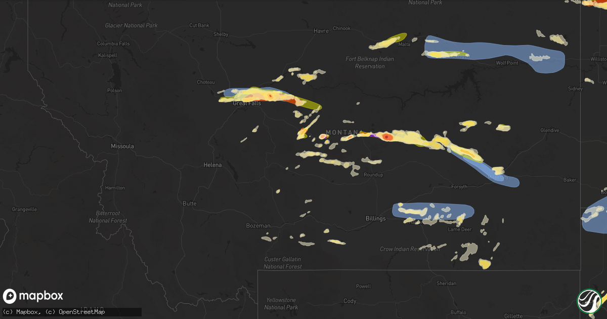
Hail Map in Montana on June 15, 2025
Get this storm
June 15 map
$229
one time, instant access
Download today. No call, no setup
Keep the $229
Bought the map and want the full workflow? Apply the entire $229 to a subscription within 7 days. None of it is wasted.
Every map, not just this one
This buys you this map. Subscription and you get every map we run, in the markets you choose from a few cities to whole states to nationwide. Plus real-time alerts the moment a storm fires.
Contact data
Name, contact info, occupancy, even credit band for addresses in the footprint. You go from where it hit to who to call.
Become the source they trust
Unlimited branding weather history reports on demand. You already have the documented answer ready for the property owner, and you are the one who showed up with it.
Property data and RoofTrace estimates
Pull up any address you have got, its value and the exact code rules for that jurisdiction, straight from One Click Code. Then RoofTrace estimates the squares, pitch, and roof value, priced the way you price.
Storm reports in Montana
Montana
| Date | Description |
|---|---|
| 06/15/20256:57 PM CDT | Report from mping: quarter |
| 06/15/20256:25 PM CDT | Time estimated based on radar. |
| 06/15/20256:05 PM CDT | Report on social media showed golf ball sized hail with estimated 60 mph wind gusts. Time estimated based on radar. |
| 06/15/20255:48 PM CDT | Trained spotter reports egg to tennis ball size hail. Images were provided. |
| 06/15/20255:30 PM CDT | Report from social media. Hail started at 4:30 pm and lasted for approximately 15 minutes. |
| 06/15/20255:30 PM CDT | Social media image of approximately golf ball sized hail in highwood. Time estimated using radar. |
| 06/15/20255:10 PM CDT | Trained spotter reports quarter size to slightly larger than quarter size hail. |
| 06/15/20255:10 PM CDT | Quarter size hail reported. |
| 06/15/20255:10 PM CDT | Trained spotter reports quarter size to slightly larger than q |
| 06/15/20255:06 PM CDT | Social media report of 1 inch hail. Time and location estimated. |
| 06/15/20255:05 PM CDT | Social media report of three quarter of an inch to an inch sized hail. |
| 06/15/20255:01 PM CDT | Social media report of one inch diameter hail in fort benton. |
| 06/15/20255:00 PM CDT | Trained spotter reports quarter size hail along with 30 to 50 mph winds along highway 87 north of the republic services landfill and south of dent bridge road. |
| 06/15/20255:00 PM CDT | Public report with image of quarter sized hail next to a quarter for reference. |
| 06/15/20255:00 PM CDT | Public report with image of ping pong sized hail near north middle school. |
| 06/15/20255:00 PM CDT | Quarter size hail reported. |
| 06/15/20254:55 PM CDT | Ambient weather station. |
| 06/15/20254:40 PM CDT | Quarter size hail reported. Damage to vehicles and rv reported as well. |
| 06/15/20254:25 PM CDT | Quarter size hail reported by member of the public. |
| 06/15/20254:24 PM CDT | Report from mping: quarter |
| 06/15/20253:20 PM CDT | Trained spotter reports hail of quarter size to half dollar size along us-87 between moccasin and windham. Damage to automobiles reported as well. |
| 06/15/20253:10 PM CDT | Public caller updated with golf ball sized hail a few minutes after initial call. |
| 06/15/20253:05 PM CDT | Public report of quarter sized hail around benchland. |
| 06/15/20251:54 AM CDT | A local report indicates 77 MPH wind near 7 SE Ekalaka |
| 06/15/20251:30 AM CDT | A local report indicates 71 MPH wind near 4 NE Medicine Rocks Sta |
| 06/15/20251:15 AM CDT | Mesonet station mteka baker mt-7 mp 14.2. |
| 06/15/20251:00 AM CDT | Ash creek mt dot |
| 06/14/202511:16 PM CDT | Bloomfield... Mt |
| 06/14/202511:12 PM CDT | A local report indicates 81 MPH wind near 3 WNW Miles City |
| 06/14/202510:50 PM CDT | A local report indicates 58 MPH wind near 2 NW Rock Springs |
| 06/14/202510:45 PM CDT | Badger creek (aprswxnet/c |
| 06/14/202510:45 PM CDT | Badger creek |
| 06/14/202510:40 PM CDT | Corrects previous tstm wnd gst report from 10 w homestead. Public reported on facebook... And 0.5 inches of rain. |
| 06/14/202510:40 PM CDT | A local report indicates 60 MPH wind near 10 SSE Bighorn |
| 06/14/202510:35 PM CDT | Awos station k00u 2 wnw hardin. |
| 06/14/202510:20 PM CDT | Poplar raws station. Time estimated by radar. |
| 06/14/202510:18 PM CDT | Glasgow |
| 06/14/202510:18 PM CDT | Glasgow sw |
| 06/14/202510:00 PM CDT | Mesonet station mtm89 angela w. |
| 06/14/202510:00 PM CDT | Wolf point nw |
| 06/14/20259:52 PM CDT | Fort peck dam station. |
| 06/14/20259:50 PM CDT | Bredette ne |
| 06/14/20259:00 PM CDT | Nashua ne |
| 06/14/20258:50 PM CDT | Mosby se |
| 06/14/20258:42 PM CDT | Asos reported 71 mph wind gust. |
| 06/14/20258:42 PM CDT | Hail sized noted by staff at nws glasgow mt. |
| 06/14/20258:30 PM CDT | A local report indicates 1.00 inch wind near 1 NW Glasgow |
| 06/14/20258:20 PM CDT | A local report indicates 1.00 inch wind near 11 NNW Roundup |
| 06/14/20258:01 PM CDT | Large hail about 3.5 inches... Lasting for about 15 mins. |
| 06/14/20258:00 PM CDT | A storm chaser on x measured multiple hail stones of 2.5 inches in diameter with a ruler. |
| 06/14/20257:52 PM CDT | Broken windows and damage to vehicles. |
| 06/14/20257:50 PM CDT | Montana mesonet near saco. |
| 06/14/20257:45 PM CDT | A local report indicates 1.75 inch wind near 5 E Winnet |
| 06/14/20257:40 PM CDT | Trained spotter reports quarter size hail. |
| 06/14/20257:39 PM CDT | Hail up to the size of golf balls with winds 30-40 mph. |
| 06/14/20257:19 PM CDT | Report from spotter network. |
| 06/14/20257:14 PM CDT | Report from mping: ping pong ball |
| 06/14/20257:00 PM CDT | Hail ranging from pea size to half dollar size fell for about 5 minutes. |
| 06/14/20257:00 PM CDT | Spotter reported pea sized hail... Heavy rain... And winds winds 50 to 60 mph estimated. |
All States Impacted by Hail Map on June 15, 2025
Cities Impacted by Hail Map on June 15, 2025
- Terry, MT
- Brockway, MT
- Mclean, TX
- Wellington, TX
- Burbank, SD
- Vermillion, SD
- Centerville, SD
- Roy, MT
- Beresford, SD
- Quail, TX
- Mangum, OK
- Johnson, KS
- Alcester, SD
- Cohagen, MT
- Ulysses, KS
- Altus, OK
- Olustee, OK
- Blair, OK
- Headrick, OK
- Altus Afb, OK
- Hedley, TX
- Lelia Lake, TX
- Eldorado, OK
- Sand Springs, MT
- Moscow, KS
- Hudson, SD
- Hugoton, KS
- Tipton, OK
- Elmer, OK
- Frederick, OK
- Vernon, TX
- Odell, TX
- Quanah, TX
- Hawarden, IA
- Chillicothe, TX
- Davidson, OK
- Oklaunion, TX
- Harrold, TX
- Ireton, IA
- Liberal, KS
- Le Mars, IA
- Akron, IA
- Forestburg, TX
- Sunset, TX
- Paducah, TX
- Forgan, OK
- Miller, SD
- Shamrock, TX
- Saint Lawrence, SD
- Meade, KS
- Ashton, IA
- Seymour, TX
- Benjamin, TX
- Knox City, TX
- Munday, TX
- O'Brien, TX
- Crowell, TX
- Holliday, TX
- Goree, TX
- Scotland, TX
- Archer City, TX
- Electra, TX
- Weinert, TX
- Iowa Park, TX
- Wichita Falls, TX
- Newcastle, TX
- Haskell, TX
- Rochester, TX
- Graham, TX
- Olney, TX
- Throckmorton, TX
- Loving, TX
- Windthorst, TX
- Woodson, TX
- Wessington, SD
- Memphis, TX
- Breckenridge, TX
- Albany, TX
- South Bend, TX
- Caddo, TX
- Wessington Springs, SD
- Moran, TX
- Wolsey, SD
- Huron, SD
- Baird, TX
- Cisco, TX
- Clyde, TX
- Abilene, TX
- Tuscola, TX
- Buffalo Gap, TX
- Cross Plains, TX
- Ovalo, TX
- Lawn, TX
- Willow Lake, SD
- Clark, SD
- Carpenter, SD
- Yale, SD
- Goldsboro, TX
- Burkett, TX
- Coleman, TX
- Garretson, SD
- Novice, TX
- Winters, TX
- Talpa, TX
- Santa Anna, TX
- Vienna, SD
- Hazel, SD
- Bryant, SD
- Jasper, MN
- Henry, SD
- Gustine, TX
- Whitney, TX
- Holden, LA
- Aquilla, TX
- Webster, SD
- Roslyn, SD
- Leesville, LA
- McGregor, TX
- Eden, SD
- Fort Hood, TX
- Temple, TX
- Nolanville, TX
- Belton, TX
- Woodbine, GA
- Hobson, MT
- Plantersville, TX
- Navasota, TX
- Gainesville, MO
- Georgetown, TX
- Splendora, TX
- Cleveland, TX
- Florence, TX
- New Caney, TX
- Llano, TX
- Kingsland, TX
- Porter, TX
- Spring, TX
- Smithville, TX
- Lake Park, GA
- Statenville, GA
- Horseshoe Bay, TX
- Conroe, TX
- Moore, MT
- Stanford, MT
- Rockdale, TX
- Weston, CO
- Brookings, SD
- Lexington, TX
- Caldwell, TX
- Bryan, TX
- Mayhill, NM
- Paige, TX
- Hearne, TX
- Houston, TX
- North Zulch, TX
- Normangee, TX
- Denton, MT
- Fort Benton, MT
- Boykins, VA
- Tinnie, NM
- Aurora, SD
- Branchville, VA
- Dime Box, TX
- Newsoms, VA
- Lincoln, TX
- Moccasin, MT
- Smiley, TX
- Loma, MT
- Wrightsboro, TX
- Interlachen, FL
- Gonzales, TX
- Flatonia, TX
- La Grange, TX
- Springfield, GA
- Muldoon, TX
- West Point, TX
- Wimberley, TX
- Spring Branch, TX
- Pomona, MO
- Grapeland, TX
- Canyon Lake, TX
- Blanco, TX
- Slayton, MN
- Roswell, NM
- Fairfield, MT
- Melrose, FL
- Crockett, TX
- Richmond, VA
- Artesia, NM
- Fort Shaw, MT
- Sun River, MT
- Vaughn, MT
- Florahome, FL
- West Plains, MO
- Alto, TX
- Sanborn, IA
- Paullina, IA
- Chunchula, AL
- Power, MT
- Carlsbad, NM
- Great Falls, MT
- Corona, NM
- Mountain View, MO
- Patterson, GA
- Hortense, GA
- Nahunta, GA
- Clayton, NC
- Hagerman, NM
- Black Eagle, MT
- Floweree, MT
- Birch Tree, MO
- Elizabeth, CO
- Clarion, IA
- Highwood, MT
- Wilmont, MN
- Lismore, MN
- Creston, IA
- Hartley, IA
- Freeman, VA
- Emporia, VA
- Lawrenceville, VA
- Jbsa Randolph, TX
- Converse, TX
- Kiowa, CO
- Cibolo, TX
- Richton, MS
- Fischer, TX
- Ocheyedan, IA
- Bulverde, TX
- State Line, MS
- Akron, CO
- Lockhart, TX
- New Braunfels, TX
- Geyser, MT
- Luling, TX
- Orient, IA
- Capitan, NM
- Jarratt, VA
- White Sulphur Springs, MT
- Melvin, IA
- Merriman, NE
- Remsen, IA
- Kingsley, IA
- Geraldine, MT
- Dows, IA
- Stockett, MT
- San Antonio, TX
- Big Sandy, MT
- Pearsall, TX
- Helotes, TX
- Lewistown, MT
- Fort Morgan, CO
- Marcus, IA
- Fort Sumner, NM
- Brush, CO
- Worthington, MN
- Vaughn, NM
- Louisburg, NC
- Spring Hope, NC
- Alden, IA
- Cody, NE
- Rocky Mount, NC
- Elm City, NC
- Pinetops, NC
- Millry, AL
- Chatom, AL
- Pipestone, MN
- Weldona, CO
- Harris, IA
- Whitakers, NC
- Tarboro, NC
- Battleboro, NC
- Castalia, NC
- Coffee Creek, MT
- Arcadia, FL
- Charlotte, TX
- Jourdanton, TX
- Frankville, AL
- Springer, NM
- Taiban, NM
- Enfield, NC
- Jackson, AL
- Okabena, MN
- Lakefield, MN
- Brewster, MN
- Dodson, MT
- Lake Park, IA
- Bigfoot, TX
- Malta, MT
- Forest Grove, MT
- Grass Range, MT
- Grove Hill, AL
- Wilsall, MT
- Savannah, GA
- Moore, TX
- Kimball, NE
- Elida, NM
- Livingston, MT
- Bozeman, MT
- Colorado Springs, CO
- Harrisburg, NE
- Dix, NE
- Snyder, CO
- Buffalo, MT
- Two Dot, MT
- Fortuna, ND
- Ledyard, IA
- Swea City, IA
- Lenox, IA
- Glenrock, WY
- Camden, NC
- Potter, NE
- Gillette, WY
- Cotulla, TX
- Scotland Neck, NC
- Sidney, NE
- Floyd, NM
- Melrose, NM
- Usaf Academy, CO
- Madrid, IA
- Woodward, IA
- Ambrose, ND
- Clearfield, IA
- Gurley, NE
- Diagonal, IA
- Crosby, ND
- Dalton, NE
- Winnett, MT
- Raton, NM
- Peetz, CO
- Bayard, NE
- Bedford, IA
- Richmond Hill, GA
- Peyton, CO
- Hinsdale, MT
- Judith Gap, MT
- Saco, MT
- Lovell, WY
- Cowley, WY
- Whatley, AL
- Armstrong, IA
- Beeville, TX
- Fort Peck, MT
- Hilger, MT
- Clovis, NM
- Mosby, MT
- Brusett, MT
- Calhan, CO
- Hulett, WY
- Devils Tower, WY
- Moorcroft, WY
- Fairmont, MN
- Blockton, IA
- Noonan, ND
- Columbus, ND
- Lead, SD
- Deadwood, SD
- Spearfish, SD
- Whitewood, SD
- Ryegate, MT
- Batesland, SD
- Lavina, MT
- Glasgow, MT
- Martin, SD
- Greenfield, IA
- Porcupine, SD
- Allen, SD
- McLeod, MT
- Griswold, IA
- Greenville, NC
- Redfield, IA
- Earlham, IA
- Nashua, MT
- Vandalia, MT
- Saint Marie, MT
- Vale, SD
- Nisland, SD
- Wounded Knee, SD
- Martinsdale, MT
- Red Oak, IA
- Elliott, IA
- Lewis, IA
- Sturgis, SD
- Marne, IA
- Atlantic, IA
- Clarinda, IA
- Nodaway, IA
- Corning, IA
- Adel, IA
- New Raymer, CO
- Lodgepole, NE
- Padroni, CO
- Roberts, MT
- Newell, SD
- Oshkosh, NE
- Roundup, MT
- Chappell, NE
- Lewellen, NE
- Lisco, NE
- Big Springs, NE
- Brule, NE
- Ogallala, NE
- Keystone, NE
- Lemoyne, NE
- Arthur, NE
- Wolf Point, MT
- Frazer, MT
- Forsyth, MT
- Granger, IA
- Wanblee, SD
- Big Timber, MT
- Poplar, MT
- New Underwood, SD
- Oelrichs, SD
- Nye, MT
- Absarokee, MT
- Hermosa, SD
- Scenic, SD
- Angela, MT
- Hardin, MT
- Owanka, SD
- Hays, MT
- Pine Ridge, SD
- Heber Springs, AR
- Fishtail, MT
- Caputa, SD
- Pompeys Pillar, MT
- Lodge Grass, MT
- Kyle, SD
- Hershey, NE
- Manderson, SD
- Wall, SD
- Wasta, SD
- Paxton, NE
- Brockton, MT
- Westby, MT
- Roscoe, MT
- Red Lodge, MT
- Vredenburgh, AL
- Oglala, SD
- Plentywood, MT
- Mullen, NE
- Otter, MT
- Homestead, MT
- Medicine Lake, MT
- Bighorn, MT
- Tryon, NE
- North Platte, NE
- Crow Agency, MT
- Busby, MT
- Birney, MT
- Miles City, MT
- Kinsey, MT
- Decker, MT
- Valentine, NE
- Conchas Dam, NM
- Sutherland, NE
- Maxwell, NE
- Lambert, MT
- Fairview, MT
- Culbertson, MT
- Froid, MT
- Kadoka, SD
- Interior, SD
- Philip, SD
- Quinn, SD
- Ballantine, MT
- Worden, MT
- Rosebud, MT
- Volborg, MT
- Newkirk, NM
- Lame Deer, MT
- Stapleton, NE
- Ismay, MT
- Cherry Creek, SD
- Curtis, NE
- Maywood, NE
- Colstrip, MT
- Cartwright, ND
- Moorefield, NE
- Indianola, NE
- Bartley, NE
- Buffalo, SD
- Bowman, ND
- Camp Crook, SD
- Meadow, SD
- Rhame, ND
- Ludlow, SD
- Alzada, MT
- Lemmon, SD
- New England, ND
- Timber Lake, SD
- Scranton, ND
- Glencross, SD
- Dupree, SD
- Trail City, SD
- McIntosh, SD
- Ralph, SD
- Reva, SD
- Reeder, ND
- Wakpala, SD
- Lodgepole, SD
- Amidon, ND
- Prairie City, SD
- Hettinger, ND
- Regent, ND
- McLaughlin, SD
- Selfridge, ND
- Keldron, SD
- Watford City, ND
- Agar, SD
- New Leipzig, ND
- Watauga, SD
- Mound City, SD
- Mott, ND
- Bison, SD
- Elgin, ND
- Eureka, SD
- Carson, ND
- Shields, ND
- Pollock, SD
- Herreid, SD
- Solen, ND
- Highmore, SD
- Raleigh, ND
- Fort Yates, ND
- Flasher, ND
- Ashley, ND
- Zeeland, ND
- Hague, ND
- Strasburg, ND
- Linton, ND
- Hazelton, ND
- Wishek, ND
- Mandan, ND
- Cannon Ball, ND
- Bancroft, IA
- Walker, SD
- Morristown, SD
- Saint Anthony, ND
- Ipswich, SD
- Roscoe, SD
- Kintyre, ND
- Saint Onge, SD
- Braddock, ND
- Bruce, SD
- Moffit, ND
- Estelline, SD
- Toronto, SD
- Napoleon, ND
- Saint James, MN
- Steele, ND
- Lehr, ND
- Clear Lake, SD
- Dawson, ND
- Westport, SD
- Edgeley, ND
- Kulm, ND
- Fredonia, ND
- Tappen, ND
- Streeter, ND
- Turton, SD
- Gackle, ND
- Conde, SD
- Raymond, SD
- Frederick, SD
- Minnesota Lake, MN
- Jud, ND
- Ellendale, ND
- Fullerton, ND
- Oakes, ND
- Jamestown, ND
- Montpelier, ND
- Dickey, ND
- Berlin, ND
- Britton, SD
- Waubay, SD
- Grenville, SD
- Lamoure, ND
- Cogswell, ND
- Marion, ND
- Bricelyn, MN
- Blue Earth, MN
- Litchville, ND
- Fort Ransom, ND
- Verona, ND
- Spiritwood, ND
- Havana, ND
- Stirum, ND
- Wells, MN
- Easton, MN
- Forman, ND
- Sanborn, ND
- Peever, SD
- Sisseton, SD
- Lisbon, ND
- Saint Peter, MN
- New Effington, SD
- Tower City, ND
- Milnor, ND
- Kiester, MN
- Hankinson, ND
- Wyndmere, ND
- Alden, MN
- Rosholt, SD
- Fairmount, ND
- Wahpeton, ND
- Wheaton, MN
- West Fargo, ND
- Fargo, ND
- Davenport, ND
- Horace, ND
- Moorhead, MN
- Blooming Prairie, MN
- Sabin, MN
- Rothsay, MN
- Barnesville, MN
- Pelican Rapids, MN
- Mapleton, MN
- Waltham, MN
- Brownsdale, MN
- Delavan, MN
- Austin, MN
- Emmons, MN
- Conger, MN
- Albert Lea, MN
- Hawley, MN


