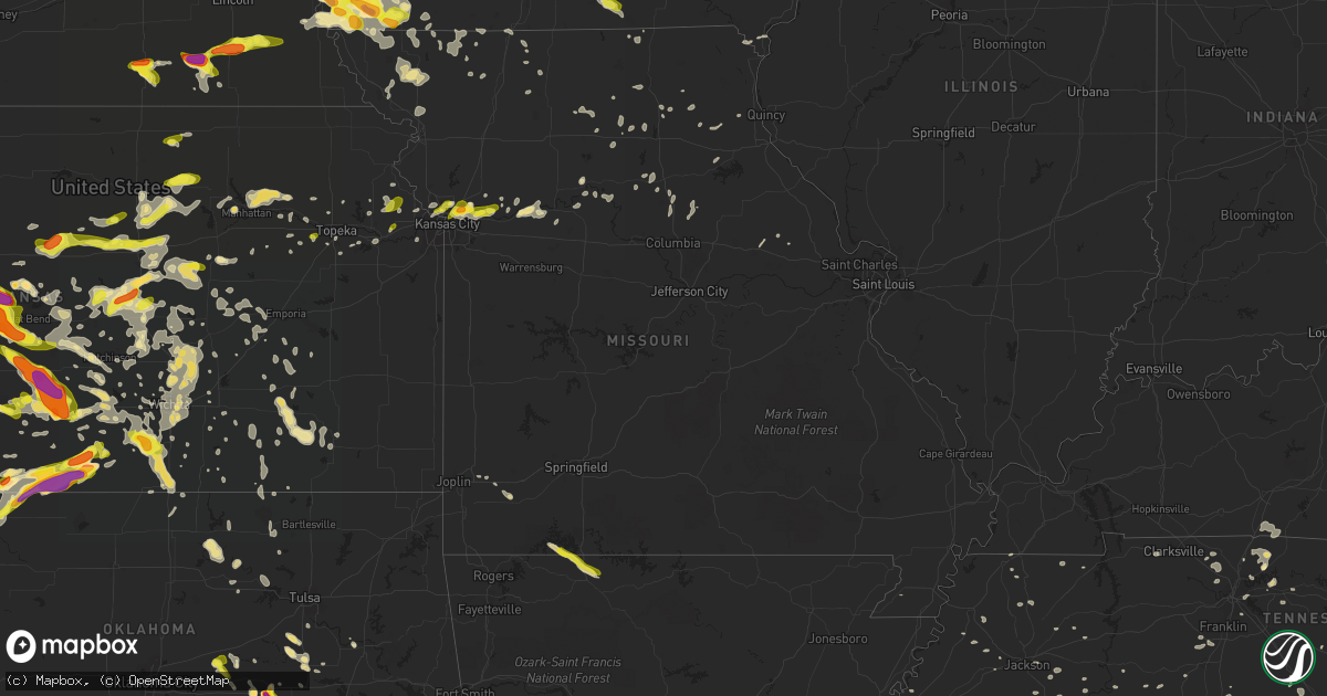
Hail Map in Missouri on June 15, 2017
Get this storm
June 15 map
$229
one time, instant access
Download today. No call, no setup
Keep the $229
Bought the map and want the full workflow? Apply the entire $229 to a subscription within 7 days. None of it is wasted.
Every map, not just this one
This buys you this map. Subscription and you get every map we run, in the markets you choose from a few cities to whole states to nationwide. Plus real-time alerts the moment a storm fires.
Contact data
Name, contact info, occupancy, even credit band for addresses in the footprint. You go from where it hit to who to call.
Become the source they trust
Unlimited branding weather history reports on demand. You already have the documented answer ready for the property owner, and you are the one who showed up with it.
Property data and RoofTrace estimates
Pull up any address you have got, its value and the exact code rules for that jurisdiction, straight from One Click Code. Then RoofTrace estimates the squares, pitch, and roof value, priced the way you price.
Storm reports in Missouri
Missouri
| Date | Description |
|---|---|
| 06/15/20179:55 AM CDT | Quarter size hail reported at the post office in blue eye. |
| 06/15/201712:30 AM CDT | Power poles and lines down. |
| 06/14/201711:30 PM CDT | Tree down blocking crowder rd. At mable st. |
| 06/14/201711:23 PM CDT | Tree down blocking crowder rd. At mable st. |
| 06/14/201711:15 PM CDT | Tree limbs down blocking roads...time estimated. |
| 06/14/201711:04 PM CDT | Roof partially damaged on residence... Garage roof taken off... Outbuildings destroyed between blythedale and cainsville. |
| 06/14/201711:03 PM CDT | Outbuildings destroyed on w. 200th st. East of washington center. |
| 06/14/201711:03 PM CDT | Machine shed destroyed. Power lines down from ridgeway to cainsville to blythedale... Along with power outages in those areas... Including eagleville. |
| 06/14/201711:03 PM CDT | *** 2 inj *** tree fell on mobile home on the 200 block of second street... Temporarily trapping two people. Both people sustained minor to moderate injuries. |
| 06/14/201711:03 PM CDT | *** 1 inj *** semi blown off of i-35 nb near mm 99 with driver sustaining minor injuries. |
| 06/14/20179:53 PM CDT | Quarter size hail reported via facebook. |
| 06/14/20179:53 PM CDT | Several trees down across western portions of nodaway county per 911 dispatch communications. |
| 06/14/20179:38 PM CDT | Reports coming into dispatch of trees down across hwy 45 near waldron. |
| 06/14/20179:35 PM CDT | A local report indicates 1.50 inch wind near 1 WSW LIBERTY |
| 06/14/20179:35 PM CDT | Quarter size hail reported via facebook near i-35 and chouteau trfwy. |
| 06/14/20179:32 PM CDT | Estimated 55-60 mph near 152 and n. Oak trfwy. |
| 06/14/20179:32 PM CDT | Near the intersection of 152 and n. Oak trfwy. |
| 06/14/20179:28 PM CDT | Numerous reports of trees and limbs down in the riss lake area as well as other parts of parkville. |
| 06/14/20179:15 PM CDT | Numerous tree limbs blown down in the area of nw 67th st. And n overland dr. Time estimated from radar. |
| 06/14/20179:05 PM CDT | Reports coming into dispatch of trees down across hwy 45 near waldron |
All States Impacted by Hail Map on June 15, 2017
Cities Impacted by Hail Map on June 15, 2017
- Waynesboro, TN
- Iowa Falls, IA
- Hampton, IA
- Uniontown, AL
- Safford, AL
- Marion Junction, AL
- Bessemer, AL
- Adger, AL
- Sterling, KS
- Nickerson, KS
- Partridge, KS
- Raymond, KS
- Abbyville, KS
- Hutchinson, KS
- Alden, KS
- Isabel, KS
- Medicine Lodge, KS
- Catherine, AL
- Otley, IA
- Ness City, KS
- Saucier, MS
- Diberville, MS
- Biloxi, MS
- Clarendon, TX
- Clanton, AL
- Theodore, AL
- Irvington, AL
- Freedom, OK
- Mooreland, OK
- Morganville, KS
- Clay Center, KS
- Pleasant Grove, AL
- Birmingham, AL
- Mulga, AL
- Gallatin, TN
- Central City, IA
- Independence, IA
- Jesup, IA
- Center Point, IA
- Winthrop, IA
- Walker, IA
- Alburnett, IA
- Coggon, IA
- Brandon, IA
- Rowley, IA
- Lacona, IA
- Tracy, IA
- Chariton, IA
- Knoxville, IA
- Columbia, IA
- Leighton, IA
- Melcher Dallas, IA
- Harvey, IA
- Oskaloosa, IA
- Bussey, IA
- Hamilton, IA
- Liberty, MO
- Kansas City, MO
- Independence, MO
- Hays, KS
- Ellis, KS
- Lead Hill, AR
- Omaha, AR
- Haven, KS
- Gulfport, MS
- Purdin, MO
- Browning, MO
- Linneus, MO
- Monticello, IA
- Hopkinton, IA
- Cascade, IA
- Tulia, TX
- Hoisington, KS
- Woodlawn, TN
- Buckner, MO
- Sibley, MO
- Walnut, IA
- Cumberland, IA
- Griswold, IA
- Bridgewater, IA
- Atlantic, IA
- Massena, IA
- Lewis, IA
- Anita, IA
- Adair, IA
- Wiota, IA
- Goodwater, AL
- Miami, TX
- Pampa, TX
- Hollywood, AL
- Scottsboro, AL
- Pacific Junction, IA
- Alexander City, AL
- Okemah, OK
- Conway Springs, KS
- Wellington, KS
- Mayfield, KS
- Clearwater, KS
- Kingman, KS
- Iuka, KS
- St John, KS
- Stafford, KS
- Pratt, KS
- Larned, KS
- Turon, KS
- Cunningham, KS
- Newton, KS
- Equality, AL
- Gravity, IA
- Gail, TX
- Leavenworth, KS
- Tonganoxie, KS
- Stuart, IA
- Dexter, IA
- Springville, IA
- New Hartford, IA
- Prairieburg, IA
- Anamosa, IA
- Cedar Falls, IA
- Martelle, IA
- Dike, IA
- Cedar Rapids, IA
- Clarksville, IA
- Mount Vernon, IA
- Ackley, IA
- Dumont, IA
- Vinton, IA
- Aplington, IA
- Allison, IA
- Mechanicsville, IA
- Waterloo, IA
- Austinville, IA
- Fairbank, IA
- Palo, IA
- Hiawatha, IA
- Hazleton, IA
- Quasqueton, IA
- Toddville, IA
- Geneva, IA
- Lisbon, IA
- Latimer, IA
- Bradford, IA
- Denver, IA
- Waverly, IA
- Evansdale, IA
- Parkersburg, IA
- Stout, IA
- Marion, IA
- Shellsburg, IA
- Janesville, IA
- Urbana, IA
- Kesley, IA
- Shell Rock, IA
- Coulter, IA
- Robins, IA
- Dunkerton, IA
- Dows, IA
- Attica, KS
- Harper, KS
- Peabody, KS
- Waynesboro, MS
- Summerville, SC
- De Witt, NE
- Adams, NE
- Firth, NE
- Cortland, NE
- Pickrell, NE
- Clatonia, NE
- Ellsworth, KS
- Lorraine, KS
- Beatrice, NE
- Odell, NE
- Columbia, TN
- Santa Fe, TN
- Ovalo, TX
- Tuscola, TX
- Shenandoah, IA
- Keota, IA
- South English, IA
- Harper, IA
- Stevenson, AL
- Fackler, AL
- Marion, AL
- Hillsboro, KS
- Hazelton, KS
- Kiowa, KS
- Hardtner, KS
- Alva, OK
- Hope, KS
- Abilene, KS
- Ripley, MS
- Dumas, MS
- Weir, MS
- Loganville, GA
- Monroe, GA
- Brooklyn, IA
- Hartwick, IA
- Granger, IA
- Winfield, AL
- Clarendon, NC
- Whiteville, NC
- Chadbourn, NC
- Tabor City, NC
- Glasgow, MO
- Gilliam, MO
- Slater, MO
- Tuskegee, AL
- Belmont, MS
- Franklin, TN
- Valley Center, KS
- Wichita, KS
- Sweetwater, TX
- Montgomery, AL
- Prattville, AL
- Green Forest, AR
- Oak Grove, AR
- Byromville, GA
- Bethpage, TN
- Portland, TN
- Midland, TX
- Stanton, TX
- Woodburn, IA
- Hernando, MS
- Wakeeney, KS
- Union, NE
- Percival, IA
- Thurman, IA
- Riverton, IA
- Farragut, IA
- Tabor, IA
- Hamburg, IA
- Nebraska City, NE
- Randolph, IA
- Sidney, IA
- Holdenville, OK
- Sedgwick, KS
- Garden City, TX
- Childersburg, AL
- Benton, KS
- Whitewater, KS
- Eldridge, AL
- Bankston, AL
- Carbon Hill, AL
- Holyrood, KS
- Claflin, KS
- Ellinwood, KS
- Bushton, KS
- Rutherford, TN
- Bradford, TN
- Garden City, KS
- Ingalls, KS
- Cassoday, KS
- Perkinston, MS
- Ackerly, TX
- Levelland, TX
- Big Spring, TX
- Brownfield, TX
- Meadow, TX
- Odonnell, TX
- Lamesa, TX
- Tahoka, TX
- Ropesville, TX
- Sylacauga, AL
- Baxter, TN
- Silver Point, TN
- Smithville, TN
- Sun City, KS
- Lake City, KS
- Glen, MS
- Corinth, MS
- Belvidere, NE
- Carleton, NE
- Hebron, NE
- Alexandria, NE
- Tobias, NE
- Daykin, NE
- Bruning, NE
- Idalou, TX
- Lubbock, TX
- Truro, IA
- Osceola, IA
- New Virginia, IA
- Lucas, IA
- Murray, IA
- Prague, OK
- Stroud, OK
- Sparks, OK
- Waldron, KS
- Anthony, KS
- Coldwater, KS
- Sharon, KS
- Bison, KS
- Town Creek, AL
- Coffeeville, MS
- Tutwiler, MS
- Stockton, KS
- Golden, MS
- Coffeeville, AL
- Jackson, TN
- Senatobia, MS
- Haviland, KS
- Kellogg, IA
- Colfax, IA
- Altoona, IA
- Bondurant, IA
- Mitchellville, IA
- Newton, IA
- Prairie City, IA
- Berwick, IA
- Des Moines, IA
- Pretty Prairie, KS
- Cheney, KS
- Arlington, KS
- Dorrance, KS
- Lucas, KS
- Sylvan Grove, KS
- Norborne, MO
- Lexington, MO
- Dover, MO
- Howard, KS
- Severy, KS
- Fall River, KS
- Coahoma, TX
- Sterling City, TX
- Quitaque, TX
- Claude, TX
- South Haven, KS
- Greenville, MS
- Maryville, MO
- Barnard, MO
- Graham, MO
- Skidmore, MO
- Hale Center, TX
- Olton, TX
- Fieldton, TX
- Marengo, IA
- Urbandale, IA
- Clive, IA
- Eclectic, AL
- Tallassee, AL
- Mobile, AL
- Munising, MI
- Manistique, MI
- Riley, KS
- Manhattan, KS
- Brewton, AL
- Guin, AL
- Hendersonville, TN
- Mount Juliet, TN
- Buckatunna, MS
- Lakeview, TX
- Sumter, SC
- Wamego, KS
- Saint George, KS
- Rossville, KS
- Shattuck, OK
- Leland, MS
- Shelbyville, MO
- Forest, MS
- South Fulton, TN
- Fulton, KY
- Fluvanna, TX
- Leon, KS
- Caledonia, MS
- Murdock, KS
- Marland, OK
- Westminster, SC
- West Blocton, AL
- Franklin, KY
- Scottsville, KY
- Okmulgee, OK
- Beggs, OK
- Blanchard, IA
- Coin, IA
- College Springs, IA
- Shambaugh, IA
- Braddyville, IA
- Essex, IA
- Clarinda, IA
- Rock Port, MO
- Minter City, MS
- Waterloo, AL
- Puryear, TN
- Cottage Grove, TN
- Hopkinsville, KY
- Clarkesville, GA
- Casey, IA
- Fontanelle, IA
- Dallas Center, IA
- Johnston, IA
- Ankeny, IA
- Pleasant Hill, IA
- Grinnell, IA
- Waukee, IA
- Grimes, IA
- Lynnville, IA
- Warrior, AL
- Moulton, AL
- Cleveland, SC
- Mystic, IA
- Plano, IA
- Centerville, IA
- Windsor Heights, IA
- Monroe, IA
- Notasulga, AL
- Lelia Lake, TX
- South Wayne, WI
- Auburn, KS
- Topeka, KS
- Hamilton, MS
- Niota, IL
- Grand Marais, MI
- Montrose, IA
- Atmore, AL
- Sandy Ridge, NC
- Fargo, OK
- Paris, MO
- Shelbina, MO
- Rockford, AL
- Derby, KS
- Booth, AL
- Autaugaville, AL
- Bedford, IA
- Albany, MO
- Harrison, AR
- Fairfield, AL
- Adamsville, AL
- Dolomite, AL
- Tell, TX
- Cee Vee, TX
- Paducah, TX
- Childress, TX
- Turkey, TX
- Tuscaloosa, AL
- Fosters, AL
- Ladson, SC
- Charleston, SC
- Afton, IA
- Creston, IA
- Leola, AR
- Eureka, KS
- Tampa, FL
- Polk City, IA
- Dunbar, NE
- Ransom, KS
- Arnold, KS
- Utica, KS
- Dalton, GA
- Brierfield, AL
- Woodstock, AL
- White Hall, IL
- Roodhouse, IL
- Viola, KS
- Pleasantville, IA
- Hartford, IA
- Swan, IA
- Mount Airy, GA
- Bolton, NC
- Springfield, TN
- Cedar Hill, TN
- Mounds, OK
- Sapulpa, OK
- Colorado City, TX
- Belle Plaine, IA
- Snyder, TX
- Ryan, IA
- Masonville, IA
- Manchester, IA
- Farmington, KY
- Mayfield, KY
- Hawk Point, MO
- Middlebury, IN
- Bristol, IN
- Paxico, KS
- Macksburg, IA
- Sutter, IL
- West Point, IL
- Winterset, IA
- De Soto, IA
- Earlham, IA
- Greenfield, IA
- Cumming, IA
- Norwalk, IA
- Van Meter, IA
- Menlo, IA
- Shubuta, MS
- Wetumka, OK
- Weleetka, OK
- Molena, GA
- Thomaston, GA
- Brent, AL
- Chase, KS
- Georgetown, SC
- Beeler, KS
- Hudson, KS
- Carthage, MS
- Walnut Grove, MS
- Mcpherson, KS
- Amazonia, MO
- Savannah, MO
- Longton, KS
- Fredonia, KS
- Elk City, KS
- Marquette, KS
- Pella, IA
- Hedley, TX
- Canadian, TX
- Depew, OK
- Crump, TN
- Adamsville, TN
- Green Cove Springs, FL
- Lauderdale, MS
- Enid, MS
- Gadsden, AL
- Hancock, MI
- Calumet, MI
- Lyons, KS
- Cimarron, KS
- Meeker, OK
- Chandler, OK
- Schoenchen, KS
- Princeton, MO
- Ridgeway, MO
- Baxter, IA
- Tescott, KS
- Fulton, MS
- Mantachie, MS
- Randolph, MS
- Houlka, MS
- Prairie Du Chien, WI
- Hamilton, KS
- Aspermont, TX
- Sledge, MS
- Clifton, KS
- Douglas, NE
- Sterling, NE
- Hayden, AL
- Cleveland, AL
- Gypsum, KS
- Manchester, TN
- Abbeville, MS
- Latham, KS
- McLouth, KS
- Courtland, AL
- Burdick, KS
- Herington, KS
- Lineville, AL
- Talladega, AL
- Ashland, AL
- Millerville, AL
- Russell, KS
- Eskridge, KS
- Fairfax, OK
- Ponca City, OK
- Ralston, OK
- Plymouth, NE
- Western, NE
- New Middletown, OH
- New Springfield, OH
- North Lima, OH
- Petersburg, OH
- Youngstown, OH
- Columbiana, OH
- Gentry, MO
- Great Bend, KS
- Collyer, KS
- Otis, KS
- Rush Center, KS
- McCracken, KS
- Olmitz, KS
- Liebenthal, KS
- Pfeifer, KS
- Ogallah, KS
- La Crosse, KS
- Pawnee Rock, KS
- Albert, KS
- Gorham, KS
- Coldwater, MS
- Gautier, MS
- Blairstown, IA
- Luzerne, IA
- Goddard, KS
- Marion, SC
- Collinsville, MS
- Winfield, KS
- Northboro, IA
- Westboro, MO
- Waverly, AL
- Avoca, NE
- Weeping Water, NE
- Nehawka, NE
- Assaria, KS
- Wadley, GA
- Malvern, IA
- Macedonia, IA
- Red Oak, IA
- Henderson, IA
- Elliott, IA
- Carson, IA
- Hastings, IA
- Emerson, IA
- Silver City, IA
- Henryetta, OK
- Salem, VA
- Catawba, VA
- Victoria, KS
- Lampe, MO
- Blue Eye, MO
- Hickory, KY
- Peru, KS
- Bells, TN
- Burnsville, MS
- Norwich, KS
- Vancleave, MS
- Muskogee, OK
- Elko, GA
- Mcconnell Afb, KS
- Greenwich, KS
- Elbing, KS
- Andover, KS
- Hesston, KS
- Peck, KS
- Argonia, KS
- Garden Plain, KS
- Rose Hill, KS
- Moundridge, KS
- Potwin, KS
- Braman, OK
- Milton, KS
- Haysville, KS
- Walton, KS
- Macksville, KS
- Goessel, KS
- Kechi, KS
- Burns, KS
- Canton, KS
- Chelsea, IA
- Tama, IA
- Brookfield, MO
- Little River, KS
- Geneseo, KS
- Hilliard, FL
- Iuka, MS
- McGehee, AR
- Lebanon, TN
- Goose Creek, SC
- Memphis, TX
- Monticello, AR
- Dermott, AR
- Swanton, NE
- Strong City, KS
- Elmdale, KS
- Thomasville, AL
- Silas, AL
- Iowa City, IA
- Wellman, IA
- Kalona, IA
- Riverside, IA
- Blue Springs, MS
- Berry, AL
- Northport, AL
- North Charleston, SC
- New Cambria, MO
- Ethel, MO
- Independence, KS
- Neodesha, KS
- Udall, KS
- Ruleville, MS
- Hanahan, SC
- Kellyton, AL
- Lindsborg, KS
- Windom, KS
- Belvue, KS
- Mullins, SC
- Irwinton, GA
- Shawnee, OK
- Guntown, MS
- Saltillo, MS
- Madison, KS
- Westmoreland, KS
- Sheffield, IL
- Oakland, MS
- Grenada, MS
- Seminole, OK
- Shallowater, TX
- Zolfo Springs, FL
- Carrollton, MS
- Gage, OK
- Batesville, MS
- Courtland, MS
- Myrtle, MS
- Sturgeon, MO
- Clark, MO
- Kosciusko, MS
- Finger, TN
- Bethel Springs, TN
- Elrod, AL
- Echola, AL
- Buhl, AL
- Helena, AL
- Memphis, MI
- Folkston, GA
- Hickory, PA
- Canonsburg, PA
- Westland, PA
- Washington, PA
- McDonald, PA
- Minneapolis, KS
- Longford, KS
- Seymour, TX
- Williston, TN
- Saint Marys, KS
- Olsburg, KS
- Emmett, KS
- Onaga, KS
- Hohenwald, TN
- Summertown, TN
- Hamlin, TX
- Louisville, AL
- Clio, AL
- Buffalo, OK
- Delphos, KS
- Miltonvale, KS
- Sawyer, KS
- Ramer, AL
- Lenox, IA
- Augusta, KS
- Ridgeway, VA
- Stoneville, NC
- Emelle, AL
- Coker, AL
- Ralph, AL
- De Witt, MO
- Eatonton, GA
- Woodston, KS
- Riverside, MO
- Kansas City, KS
- Plainfield, IA
- Murray, NE
- Salina, KS
- Rose Hill, IA
- Amherst, TX
- Oakman, AL
- Five Points, TN
- Leoma, TN
- Minor Hill, TN
- Middleburg, FL
- Demopolis, AL
- Nodaway, IA
- Holly Springs, MS
- Kathleen, GA
- Pawnee, OK
- Freeport, KS
- Danville, KS
- Oakland, TN
- Davisboro, GA
- Warthen, GA
- Sandersville, GA
- Seale, AL
- Tullahoma, TN
- Lawrence, KS
- Pontotoc, MS
- South Pittsburg, TN
- Maple Hill, KS
- Stanton, IA
- Villisca, IA
- Huntsville, AL
- Wakefield, KS
- Orrick, MO
- Boley, OK
- Vincent, AL
- Cropwell, AL
- Selmer, TN
- Michie, TN
- Enterprise, KS
- De Kalb, MS
- Millington, TN
- Alpine, AL
- Huntsville, MO
- Clifton Hill, MO
- Holcomb, MS
- Charleston, MS
- Philipp, MS
- Hallsville, MO
- Centralia, MO
- Adel, IA
- Arlington, TN
- Eads, TN
- Lincoln, KS
- Brookville, KS
- New Cambria, KS
- Beverly, KS
- Solomon, KS
- Tampico, IL
- Rotan, TX
- Emden, MO
- Ariton, AL
- Wentworth, MO
- Pierce City, MO
- Monett, MO
- Corder, MO
- Waverly, MO
- Sharon, OK
- Mountainburg, AR
- Wetmore, MI
- Rumely, MI
- Au Train, MI
- Deerton, MI
- Trenary, MI
- Shingleton, MI
- Chatham, MI
- Falun, KS
- Quitman, MS
- Adolphus, KY
- Pine Hill, AL
- Alberta, AL
- Thomaston, AL
- Magnolia, AL
- Arlington, AL
- Eutaw, AL
- Mount Hope, KS
- Thorsby, AL
- Jemison, AL
- Lamoni, IA
- Eagleville, MO
- Blythedale, MO
- Lower Peach Tree, AL
- Atkins, IA
- Newhall, IA
- Wilson, KS
- Mayodan, NC
- Trent, TX
- Merkel, TX
- Oxford, KS
- Burrton, KS
- Philadelphia, MS
- Perry, GA
- Unadilla, GA
- Montezuma, GA
- Maize, KS
- Council, NC
- Lake Waccamaw, NC
- Morris, OK
- Dadeville, AL
- Camp Hill, AL
- Lincoln, AL
- Eastaboga, AL
- Wadley, AL
- Cedar Grove, TN
- New Florence, MO
- Montgomery City, MO
- Conception Junction, MO
- Guilford, MO
- Winnabow, NC
- Clifton, TN
- Elk Falls, KS
- Moline, KS
- Double Springs, AL
- Henderson, TN
- Fayetteville, TN
- Frisco City, AL
- Monroeville, AL
- Repton, AL
- McCalla, AL
- Lexington, TN
- Huron, TN
- Webster, IA
- Lone Tree, IA
- Sigourney, IA
- Sparta, TN
- Bristow, IA
- Crenshaw, MS
- Riner, VA
- Brevard, NC
- Madison Heights, VA
- Lynchburg, VA
- Dixons Mills, AL
- Sweet Water, AL
- Pickering, MO
- Hopkins, MO
- Clearmont, MO
- Walnut, MS
- Novinger, MO
- Kirksville, MO
- Elmwood, NE
- Cainsville, MO
- Russell, IA
- Williamson, IA
- Luray, KS
- Miami, MO
- Malta Bend, MO
- Tuskegee Institute, AL
- Jansen, NE
- Bennett, IA
- Tipton, IA
- Clarence, IA
- Talmage, NE
- Colwich, KS
- Andale, KS
- Hillview, IL
- Plevna, KS
- Galva, KS
- Moberly, MO
- Century, FL
- McDavid, FL
- Daviston, AL
- Cragford, AL
- Wagarville, AL
- Lovilia, IA
- Albia, IA
- Antioch, TN
- Lutts, TN
- Martin, TN
- Fruitdale, AL
- Leakesville, MS
- State Line, MS
- Vinegar Bend, AL
- Ethel, MS
- Barnsdall, OK
- Tupelo, MS
- Thomson, IL
- Shell Knob, MO
- Alpena, AR
- Berryville, AR
- Cornersville, TN
- Pulaski, TN
- Maramec, OK
- Woodward, OK
- Follett, TX
- Fort Supply, OK
- Redfield, IA
- Mineola, IA
- Glenwood, IA
- Lincolnville, KS
- Monroe, VA
- Memphis, TN
- Hermleigh, TX
- Louisville, GA
- Hancock, IA
- Oakland, IA
- Vardaman, MS
- Houston, MS
- Long Grove, IA
- Dixon, IA
- Eldridge, IA
- Davenport, IA
- Walcott, IA
- Donahue, IA
- Orrum, NC
- Lupton, MI
- Hale, MI
- Cedar Vale, KS
- McBee, SC
- Pawhuska, OK
- Okolona, MS
- Gordo, AL
- Fountain Run, KY
- McCaulley, TX
- Plattsmouth, NE
- Bonaire, GA
- Castleberry, AL
- Alta Vista, KS
- Tremont, MS
- Indianola, IA
- Beacon, IA
- Thayer, IA
- Woodbine, KS
- Oskaloosa, KS
- Linn, KS
- Haddam, KS
- Hardaway, AL
- Imogene, IA
- Fleming Island, FL
- Jacksonville, FL
- Orange Park, FL
- Berryton, KS
- Atlanta, KS
- Nauvoo, AL
- Lancaster, TN
- Buffalo Valley, TN
- Novelty, MO
- White City, KS
- Carrollton, AL
- Sterrett, AL
- Talbotton, GA
- Box Springs, GA
- Grand Bay, AL
- Morton, MS
- Pelahatchie, MS
- Silverton, TX
- New Castle, VA
- Union Springs, AL
- Fort Davis, AL
- White House, TN
- Carolina Beach, NC
- Wilmington, NC
- Jasper, AL
- Leland, NC
- Princeton, IL
- Baldwyn, MS
- Diller, NE
- Heidelberg, MS
- Huntingdon, TN
- Westport, TN
- Hamilton, AL
- Macon, MS
- Hardy, VA
- Blackwell, TX
- Sedan, KS
- Grenola, KS
- West Des Moines, IA
- Hope Hull, AL
- Bladenboro, NC
- Callao, MO
- Bevier, MO
- Halls, TN
- Spivey, KS
- Dighton, KS
- Trinity, AL
- Quail, TX
- Glenwood, MO
- Livonia, MO
- Sheridan, MO
- Grant City, MO
- Worth, MO
- Blockton, IA
- Redding, IA
- Midway, AL
- Wilsey, KS
- Pine Hall, NC
- Madison, NC
- Walnut Cove, NC
- Cedar, IA
- Kennett, MO
- Newberry, MI
- Metropolis, IL
- Sardis, MS
- Osage, OK
- Aberdeen, MS
- Plainview, TX
- Cottontown, TN
- Tillar, AR
- Woodville, AL
- Grant, AL
- Faunsdale, AL
- Waterford, MS
- Tunnel Hill, GA
- Rocky Face, GA
- Spickard, MO
- Newkirk, OK
- Auburn, AL
- Mount Pleasant, TN
- Paris, TN
- Arab, AL
- Guntersville, AL
- Gallion, AL
- Shannon City, IA
- Richmond, MO
- Nolan, TX
- Henrietta, MO
- Union City, TN
- Nesbit, MS
- Byhalia, MS
- Olive Branch, MS
- Easton, KS
- Atchison, KS
- Clinton, KY
- Fancy Farm, KY
- Mound City, MO
- Oregon, MO
- Maitland, MO
- Troy, AL
- Fitzpatrick, AL
- Washington, IA
- Saint George, GA
- Wyanet, IL
- Winchester, KS
- Savanna, IL
- Elizabeth, IL
- Mount Carroll, IL
- Elberta, AL
- Oak Grove, KY
- Lake Village, AR
- Flatgap, KY
- West Liberty, KY
- Symsonia, KY
- Boaz, KY
- Estillfork, AL
- Matfield Green, KS
- Nettleton, MS
- Smithville, MS
- Fairbury, NE
- Fairfax, IA
- Amana, IA
- Norway, IA
- Chatom, AL
- Tibbie, AL
- Deer Park, AL
- Greenfield, TN
- Fort Campbell, KY
- Pope, MS
- Mount Hope, AL
- Parrish, AL
- Cordova, AL
- Ocean Springs, MS
- Blackwell, OK
- Douglass, KS
- Morrowville, KS
- Meriden, KS
- Hoyt, KS
- Maywood, MO
- Durham, MO
- Harpersville, AL
- Pell City, AL
- Denver, MO
- Livingston, AL
- Quinton, AL
- Mount Ayr, IA
- Hatfield, MO
- Dexter, KS
- Counce, TN
- Emporia, KS
- Danville, AL
- Aurora, KS
- Bennington, KS
- Wrens, GA
- La Plata, MO
- Rising Star, TX
- Cisco, TX
- Caldwell, KS
- Thaxton, MS
- Higginsville, MO
- Hardin, MO
- Creekside, PA
- Lewisburg, TN
- Bucklin, MO
- Christiansburg, VA
- Sedalia, KY
- Bolivia, NC
- Shannon, MS
- New Boston, MO
- Allenton, MI
- Porter, OK
- Sylvia, KS
- Solon, IA
- North Liberty, IA
- Carthage, MO
- Eddyville, IA
- Hatchechubbee, AL
- Jacksons Gap, AL
- El Dorado, KS
- Walnut, IL
- Lenexa, KS
- Marion, KS
- Friendship, TN
- Hays, NC
- Olpe, KS
- Bettendorf, IA
- Parnell, MO
- Roscoe, TX
- Carlisle, IA
- Bruce, MS
- Pittsboro, MS
- Decaturville, TN
- Sardis, TN
- Scotts Hill, TN
- Delia, KS
- Whittemore, MI
- Joelton, TN
- Goodlettsville, TN
- Greenbrier, TN
- Pleasant View, TN
- Mathews, AL
- Halstead, KS
- Tampa, KS
- Roxbury, KS
- Ramona, KS
- Inman, KS
- Buhler, KS
- Sherwood, TN
- Burlington, OK
- Montevallo, AL
- Vance, AL
- Brookwood, AL
- Alabaster, AL
- Hermitage, TN
- Nashville, TN
- Rochester Mills, PA
- Punxsutawney, PA
- New Hampton, MO
- Coats, KS
- Stephens, GA
- Union Point, GA
- Saltillo, TN
- Maple City, KS
- Porterville, MS
- Fremont, IA
- Gibson, GA
- Mitchell, GA
- Mantee, MS
- Weiner, AR
- Amagon, AR
- Fisher, AR
- Higbee, MO
- Deatsville, AL
- Chester, AR
- Prairie, MS
- Sarah, MS
- Coatsville, MO
- Mingo, IA
- Union, SC
- Bartow, GA
- Alvo, NE
- Cherokee, AL
- Durham, KS
- Lehigh, KS
- Stanwood, IA
- Winters, TX
- Tripoli, IA
- Sumner, IA
- Gridley, KS
- Belle Plaine, KS
- Andersonville, GA
- Americus, GA
- Bunker Hill, KS
- Greenwood, MS
- Ashland City, TN
- Haleyville, AL
- Belvidere, TN
- Winchester, TN
- Summerdale, AL
- Foley, AL
- Trenton, MO
- Gilman City, MO
- Jamesport, MO
- Sarcoxie, MO
- Maben, MS
- Barry, IL
- Spring Hill, TN
- Thompsons Station, TN
- Brownsville, TN
- Millry, AL
- Marceline, MO
- Hominy, OK
- Cleveland, OK
- Taft, TN
- Victor, IA
- Ladora, IA
- Alma, MO
- Blackburn, MO
- Lorenzo, TX
- Ralls, TX
- Slaton, TX
- Hartselle, AL
- Swainsboro, GA
- Kite, GA
- Alma, KS
- Water Valley, MS
- Jennings, OK
- Maxwell, IA
- Cambridge, IA
- Lecompton, KS
- Vernon, AL
- Sulligent, AL
- Big Rock, VA
- Haysi, VA
- Ira, TX
- Westbrook, TX
- Burbank, OK
- La Porte City, IA
- Dewar, IA
- Alden, IA
- Delhi, IA
- Aurora, IA
- Raymond, IA
- Supply, NC
- Benoit, MS
- Cottonwood Falls, KS
- Toomsboro, GA
- Westpoint, TN
- Iron City, TN
- Ocklawaha, FL
- Meridian, MS
- Barnard, KS
- Bellflower, MO
- New Sharon, IA
- Mcminnville, TN
- Burden, KS
- Westmoreland, TN
- Meridianville, AL
- Ragland, AL
- Decatur, GA
- Ellenwood, GA
- Conley, GA
- Elmo, MO
- Burlington Junction, MO
- Tarkio, MO
- Yorktown, IA
- Bixby, OK
- Linden, TN
- Ethelsville, AL
- Reform, AL
- Bazine, KS
- Luray, TN
- Wayland, MO
- Argyle, IA
- Reeds, MO
- Milan, MO
- Atlanta, MO
- Elizabethton, TN
- Enterprise, MS
- Stonewall, MS
- Centreville, AL
- Florence, SC
- Spencer, VA
- Harrisburg, MO
- Hampton, IL
- Pleasant Valley, IA
- Robertsdale, AL
- Excelsior Springs, MO
- Toronto, KS
- Camden, MO
- Wilber, NE
- Burr, NE
- Cook, NE
- Gilead, NE
- Brownell, KS
- Plainville, KS
- Quinter, KS
- Green, KS
- Clyde, KS
- Agenda, KS
- Dodge City, KS
- Jetmore, KS
- Byers, KS
- Sudan, TX
- Littlefield, TX
- Quanah, TX
- Gilbertville, IA
- Greene, IA
- Prole, IA
- Hills, IA
- Latta, SC
- Timmonsville, SC
- Darlington, SC
- Lamar, SC


