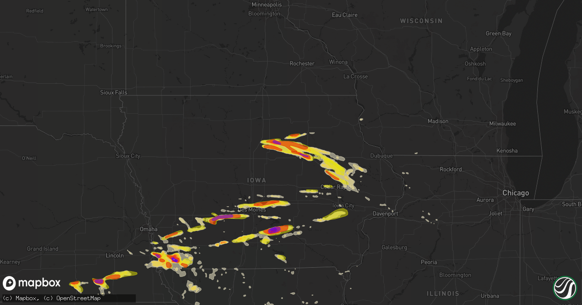
Hail Map on June 15, 2017
Get this storm
June 15 map
$229
one time, instant access
Download today. No call, no setup
Keep the $229
Bought the map and want the full workflow? Apply the entire $229 to a subscription within 7 days. None of it is wasted.
Every map, not just this one
This buys you this map. Subscription and you get every map we run, in the markets you choose from a few cities to whole states to nationwide. Plus real-time alerts the moment a storm fires.
Contact data
Name, contact info, occupancy, even credit band for addresses in the footprint. You go from where it hit to who to call.
Become the source they trust
Unlimited branding weather history reports on demand. You already have the documented answer ready for the property owner, and you are the one who showed up with it.
Property data and RoofTrace estimates
Pull up any address you have got, its value and the exact code rules for that jurisdiction, straight from One Click Code. Then RoofTrace estimates the squares, pitch, and roof value, priced the way you price.
States Impacted by Hail Map on June 15, 2017
Storm reports
Virginia
| Date | Description |
|---|---|
| 06/15/20176:17 PM CDT | Tree on a power line just south of roseland. |
| 06/15/20176:06 PM CDT | One tree down on lost mountain rd. Near 122. Time radar estimated. |
| 06/15/20175:45 PM CDT | Thunderstorm winds downed trees along hwy 122 between hardy and rocky mount... Va. |
| 06/15/20175:45 PM CDT | Tree down on jordan town rd. Time radar estimated. |
| 06/15/20175:22 PM CDT | Thunderstorm winds downed a powerpole within the community of cave spring knocking out power. |
| 06/15/20175:17 PM CDT | 54kt reported at kroa. |
| 06/15/20175:05 PM CDT | Merging thunderstorms produced a few downed trees near the salem city and roanoke county line on thursday afternoon. |
| 06/15/20174:42 PM CDT | Small tree down. Time from radar. |
| 06/15/20174:37 PM CDT | Trained spotter reports several small limbs and other debris down along catawba road |
| 06/15/20174:19 PM CDT | Thunderstorms winds downed numerous trees along union valley road near riner. An estimated 8 to 10 trees were toppled... Closing the roadway at multiple locations. |
| 06/15/20174:10 PM CDT | Thunderstorm winds downed several trees along ellett road near the city of christiansburg temporarily closing it. |
| 06/15/20174:10 PM CDT | Thunderstorm winds caused a tree and several branches to topple in a back yard along cambria street. Pea size hail was also reported at this location. |
| 06/15/20174:05 PM CDT | Thunderstorm winds downed a tree along firetower road temporarily closing it to through traffic. |
| 06/14/20179:40 PM CDT | Several trees down on highway 360 completely blocking the road. Time based on radar. |
| 06/14/20178:00 PM CDT | Thunderstorm winds resulted in numerous large branches being blown down. |
| 06/14/20177:20 PM CDT | Several reports of small to large limbs down between elon and madison heights. Roads littered with debris from both wind and water. One estimated report of between 4 to |
| 06/14/20177:20 PM CDT | Tree fell on a building near intersection of thomas road and river road. |
North Carolina
| Date | Description |
|---|---|
| 06/15/20173:00 PM CDT | Trees and powerlines down at bedford ave and bedford st. |
| 06/15/20171:40 PM CDT | Report of several trees down on george ii hwy near martinville dr. Time estimated by radar. |
| 06/14/20177:38 PM CDT | A local report indicates 1.00 inch wind near N STONEVILLE |
Michigan
| Date | Description |
|---|---|
| 06/15/20176:55 PM CDT | Hail from dime size to quarter size fell for approximately 5 minutes. |
| 06/15/20175:51 PM CDT | Golfball sized hail reported at pictured rocks golf course. |
| 06/15/20175:38 PM CDT | Marble to quarter size hail fell for 11 minutes. |
Tennessee
| Date | Description |
|---|---|
| 06/15/20172:15 PM CDT | Power outages reported in several locations as thunderstorms moved through according to svec. Time estimated by radar. |
| 06/15/20172:07 PM CDT | House on 7th street damaged by falling tree. No injuries. Time estimated from other reports in the vicinity and from radar. |
| 06/15/201712:00 PM CDT | Tspotter report and photo showed a tree down blocking petty lane in spring hill. Time estimated based on radar. |
Alabama
| Date | Description |
|---|---|
| 06/15/20176:20 PM CDT | 3 reports of downed trees in the area. |
| 06/15/20176:06 PM CDT | Tree fell onto a storage building in valley. Time estimated by radar. |
| 06/15/20176:06 PM CDT | Power lines reported down near tarrant city. Location approximate. Time estimated by radar. |
| 06/15/20176:00 PM CDT | Tree down in the willow creek subdivision. |
| 06/15/20175:51 PM CDT | Tree on house on grove ave. |
| 06/15/20175:50 PM CDT | Tree blown down. |
| 06/15/20175:50 PM CDT | Several reports of trees and power lines downed. |
| 06/15/20175:50 PM CDT | Tree blown down onto a house. |
| 06/15/20175:37 PM CDT | A local report indicates 67 MPH wind near NOTASULGA |
| 06/15/20175:25 PM CDT | Trees down on east south street. |
| 06/15/20175:25 PM CDT | Trees down on motley road in daviston. |
| 06/15/20175:21 PM CDT | Tree down long neman road near tallassee. Location approximate. Time estimated by radar. |
| 06/15/20175:19 PM CDT | Reports of trees and power lines down county-wide in randolph county. |
| 06/15/20175:15 PM CDT | Shed blown down near friendship community. |
| 06/15/20175:14 PM CDT | Power lines down at holtville high school. |
| 06/15/20175:13 PM CDT | Tree in road at the intersection of buyck rd. And jackson trace rd. |
| 06/15/20175:10 PM CDT | *** 1 inj *** a cinder block wall fell onto a woman. She was injured and taken to the hospital. |
| 06/15/20175:08 PM CDT | Small tree down on road at the intersection of balm rd. & mt. Zion rd. |
| 06/15/20175:07 PM CDT | A lot of additional reports of downed trees and power lines/poles across the county. |
| 06/15/20175:04 PM CDT | Power lines down. |
| 06/15/20175:02 PM CDT | Tree on road at grier rd. & old grier rd. |
| 06/15/20174:46 PM CDT | Tree down along pliers mill road. Location approximate. Time estimated by radar. |
| 06/15/20174:46 PM CDT | Tree down near the intersection of bailey road and bluff valley road. Location approximate. Time estimated by radar. |
| 06/15/20174:45 PM CDT | Trees and power lines downed. |
| 06/15/20174:45 PM CDT | Tree down across road. |
| 06/15/20174:45 PM CDT | Tree down on road. |
| 06/15/20174:45 PM CDT | Trees and power lines down. |
| 06/15/20174:38 PM CDT | Tree down along lake gerald road. Location approximate. Time estimated by radar. |
| 06/15/20174:35 PM CDT | Power lines down. |
| 06/15/20174:34 PM CDT | Trees reported down along east mill road. Location approximate. Time estimated by radar. |
| 06/15/20174:34 PM CDT | Tree and power lines down along alabama highway 9 near barfield. Time estimated by radar. |
| 06/15/20174:34 PM CDT | Tree down along clay county road 30. Location approximate. Time estimated by radar. |
| 06/15/20174:32 PM CDT | Trees and power lines down. |
| 06/15/20174:30 PM CDT | Multiple trees down along state lake road near delta... Al. Location approximate. Time estimated by radar. |
| 06/15/20174:28 PM CDT | Several trees down along hipine road. Time estimated by radar. Location approximate. |
| 06/15/20174:28 PM CDT | Tree and power lines down near the intersection of taylor road and tyson road. Time estimated by radar. |
| 06/15/20174:28 PM CDT | Tree down near the intersection of alabama highway 9 and 5th street in ashland. Time estimated by radar. |
| 06/15/20174:26 PM CDT | Tree down along dinner road in ashland. Time estimated by radar. |
| 06/15/20174:26 PM CDT | Tree down along highway 77 west of ashland. Time estimated by radar. |
| 06/15/20174:24 PM CDT | Tree on fire with power lines down across roadway of alabama highway 49 north near able road. Time estimated by radar. |
| 06/15/20174:20 PM CDT | Tree down along creeds road. Location approximate. Time estimated by radar. |
| 06/15/20174:16 PM CDT | Tree down along mines road in millerville. Time estimated by radar. |
| 06/15/20174:15 PM CDT | Several trees uprooted along county road 103. |
| 06/15/20174:00 PM CDT | Trees on houses near peaceburg rd. And jacksonville st. |
| 06/15/20173:58 PM CDT | Several trees uprooted along county road 26. |
| 06/15/20173:56 PM CDT | Several trees uprooted in the riverside community. |
| 06/15/20173:55 PM CDT | Tree down on pelham rd. In jacksonville. |
| 06/15/20173:55 PM CDT | Tree down at the intersection of glade rd. & bellvue rd. |
| 06/15/20173:54 PM CDT | Tree and large branches blown down. |
| 06/15/20173:53 PM CDT | Tree down along alabama highway 77. Time estimated by radar. |
| 06/15/20173:50 PM CDT | Tree down between lee lane and florey street/county road 85. |
| 06/15/20173:48 PM CDT | Tree blown down. |
| 06/15/20173:48 PM CDT | Tree reported down along highway 62 near harpersville. Time estimated by radar. |
| 06/15/20173:48 PM CDT | Tree down. |
| 06/15/20173:48 PM CDT | Tree down. |
| 06/15/20173:45 PM CDT | Tree on house; no injuries reported. |
| 06/15/20173:42 PM CDT | Power lines down along highway 109 near westover. Location approximate. Time estimated by radar. |
| 06/15/20173:40 PM CDT | Tree down on county road 43. |
| 06/15/20173:40 PM CDT | Tree down on al 68 at cr 140 near al/ga state line. |
| 06/15/20173:40 PM CDT | Tree on power lines along alabama highway 35. |
| 06/15/20173:25 PM CDT | Trees reported down. Location approximate. Time estimated by radar. |
| 06/15/20173:25 PM CDT | Several trees uprooted. |
| 06/15/20173:23 PM CDT | Several trees down and snapped. Power outages reported. |
| 06/15/20173:20 PM CDT | Two trees uprooted. |
| 06/15/20173:15 PM CDT | Several trees uprooted along county road 103. |
| 06/15/20173:14 PM CDT | Power lines down near the intersection of 9th avenue and 9th street in bessemer. Time estimated by radar. |
| 06/15/20173:12 PM CDT | High winds removed roof from double b auto sales off of 20th street and it landed onto vehicles in parking lot. Time estimated by radar. Location approximate. |
| 06/15/20173:10 PM CDT | Roof blown off canada auto sales building in bessemer. |
| 06/15/20173:10 PM CDT | Tree and power pole downed. |
| 06/15/20173:10 PM CDT | Trees down on county road 261 near adamsburg. Time estimated from radar. |
| 06/15/20173:06 PM CDT | Trees reported down along johns road near adger. Time estimated by radar. Location approximate. |
| 06/15/20173:06 PM CDT | Trees down in hueytown and in the virginia mines area. Location approximate. Time estimated by radar. |
| 06/15/20173:05 PM CDT | Several trees downed in the area. |
| 06/15/20173:00 PM CDT | Large part of a tall tree fell onto a house. |
| 06/15/20173:00 PM CDT | Tree and power pole damage reported near forestdale. Location approximate. Time estimated by radar. |
| 06/15/20173:00 PM CDT | Tree downed onto a house. |
| 06/15/20172:56 PM CDT | Ham radio report of power outage due to high winds. Location approximate. Time estimated by radar. |
| 06/15/20172:53 PM CDT | Reported along hwy 229 north of geraldine. |
| 06/15/20172:50 PM CDT | *** 1 inj *** tree down on a mobile home on plunkett dr. |
| 06/15/20172:44 PM CDT | Two chicken houses were damaged. Two large sections of metal roofing blown off. Time estimated from radar. |
| 06/15/20172:41 PM CDT | Tree down along bagley road near bagley. Location approximate. Time estimated by radar. |
| 06/15/20172:41 PM CDT | Large tree down on a house along county road 329. Time estimated from radar. |
| 06/15/20172:39 PM CDT | Numerous trees down in hanceville. Time estimated from radar. |
| 06/15/20172:37 PM CDT | A tree was blown down. |
| 06/15/20172:35 PM CDT | Trees down along hwy 71 and hwy 40 in the pleasant view community. |
| 06/15/20172:35 PM CDT | Tree down near the intersection of hwy 75 and west concord rd. Time estimated from radar. |
| 06/15/20172:30 PM CDT | Tree down on a car near cottonville rd and natural bridge ln. Time estimated from radar. |
| 06/15/20172:28 PM CDT | Trees down on hodges street in woodville. |
| 06/15/20172:25 PM CDT | Numerous trees down in cullman. Time estimated from radar. |
| 06/15/20172:25 PM CDT | Tree down on armstrong road. Time estimated from radar. |
| 06/15/20172:22 PM CDT | Tree down across junkins rd. Time estimated from radar. |
| 06/15/20172:17 PM CDT | Tree down blocking fishtrap road near grant road. Time estimated from radar. |
| 06/15/20172:11 PM CDT | Tree down across lookout drive. Time estimated from radar. |
| 06/15/20172:06 PM CDT | A tree was knocked down on indian springs drive. Delayed report. |
| 06/15/20171:53 PM CDT | Trees down along hurricane creek rd. |
| 06/15/20171:47 PM CDT | Tree down near the intersection of hwy 431 and dug hill road. Time estimated from radar. |
| 06/15/20171:43 PM CDT | A tree was down blocking the road. |
| 06/15/20171:42 PM CDT | Multiple trees down in hartselle. Time estimated from radar. |
| 06/15/20171:42 PM CDT | A large tree down in jones valley. |
| 06/15/20171:40 PM CDT | Tree down on power lines on broadmor rd. Time estimated from radar. |
| 06/15/20171:38 PM CDT | *** 1 inj *** a tree fell on a truck... Trapping and seriously injuring one person. |
| 06/15/20171:35 PM CDT | Multiple trees down in decatur. Time estimated from radar. |
| 06/15/20171:33 PM CDT | Power lines were blown down and blocking the intersection. |
| 06/15/20171:32 PM CDT | Tree across balch road. Time estimated from radar. |
| 06/15/20171:29 PM CDT | Trees down on blankenship road. |
| 06/15/20171:20 PM CDT | Several trees down near the intersection of nick davis rd. And mooresville rd. From outflow winds. |
| 06/15/20171:14 PM CDT | A dead tree down on highway 31 at pryor street. |
| 06/15/20171:11 PM CDT | A tree knocked down on highway 33 just north of moulton. |
| 06/15/20171:04 PM CDT | A tree was knocked down on highway 101 just south of the tn state line. Delayed report. |
| 06/15/20171:03 PM CDT | A tree was knocked dwn at bradshaw drive at cedar ridge. |
| 06/15/20171:03 PM CDT | A power line was down on a tree on cedar street. Delayed report. |
| 06/15/20171:03 PM CDT | Power lines were knocked down at cr 33 at blue heron drive. |
| 06/15/20171:02 PM CDT | A tree was knocked down on bradshaw drive. Delayed report. |
| 06/15/20171:02 PM CDT | A power line was knocked down at cr323 at florence blvd. Delayed report. |
| 06/15/20171:00 PM CDT | Two trees down on highway 101 near hatton. |
| 06/15/201712:36 PM CDT | Tree down blocking the road at 535 dulin street. Delayed report. |
| 06/15/201712:32 PM CDT | A tree was knocked down on the road at cr 502 between highway 64 and second creek. |
| 06/15/201712:30 PM CDT | A tree was knocked down along cr 489. Delayed report. |
| 06/14/20177:15 PM CDT | Damage to a tin shed and nearby trees reported near blue springs. Location approximate. Time estimated by radar. |
Oklahoma
| Date | Description |
|---|---|
| 06/15/20176:40 PM CDT | May ranch site. |
| 06/15/20176:35 PM CDT | May ranch site. |
| 06/15/20176:27 PM CDT | A local report indicates 1.00 inch wind near FREEDOM |
| 06/15/20176:16 PM CDT | A local report indicates 2.50 inch wind near 5 ESE CATESBY |
| 06/15/20175:20 PM CDT | Reported by kwtv. |
| 06/15/20175:05 PM CDT | Relayed by kwtv. |
| 06/15/201710:55 AM CDT | A local report indicates 1.00 inch wind near YEAGER |
| 06/15/201710:30 AM CDT | Hwy 27 |
| 06/15/201710:30 AM CDT | Nickel to quarter hail. |
| 06/15/201710:15 AM CDT | A local report indicates 2.00 inch wind near BEARDEN |
| 06/15/201710:11 AM CDT | A local report indicates 1.75 inch wind near BEARDEN |
| 06/14/201711:43 PM CDT | Trees down in westville. Power outages reported. |
| 06/14/201711:39 PM CDT | Trees down along chewey road by the chewey store. |
| 06/14/201711:35 PM CDT | A local report indicates 58 MPH wind near 2 SSE WEBBERS FALLS |
| 06/14/201711:10 PM CDT | Large tree down |
| 06/14/201711:05 PM CDT | A local report indicates 60 MPH wind near ADAIR |
| 06/14/201711:00 PM CDT | Large tree and branches down. Some branches having fallen on transformer. |
| 06/14/201710:55 PM CDT | Several power poles down on east side of town. |
| 06/14/201710:45 PM CDT | Tree down on house. Wind estimated 65 mph. |
| 06/14/201710:40 PM CDT | Side of balcony blown off at apartment complex near 61st and memorial. Time estimated. Report via social media. |
| 06/14/201710:31 PM CDT | A local report indicates 60 MPH wind near NARCISSA |
| 06/14/201710:23 PM CDT | Large tree down on house. Back half of car crushed by falling tree.. |
| 06/14/201710:15 PM CDT | 58 mph thunderstorm wind gusts |
| 06/14/201710:10 PM CDT | A local report indicates 63 MPH wind near PRYOR |
| 06/14/201710:05 PM CDT | A local report indicates 65 MPH wind near 3 NW OWASSO |
| 06/14/201710:00 PM CDT | 10 to 12 inch diameter tree snapped. Previously damaged. Time and location estimated. Report via social media. |
| 06/14/20179:50 PM CDT | Several large tree limbs down across town |
| 06/14/20179:40 PM CDT | A local report indicates 68 MPH wind near PAWHUSKA |
| 06/14/20179:20 PM CDT | Several trees down across the city |
| 06/14/20179:15 PM CDT | At blackwell-tonkawa municipal airport. |
| 06/14/20179:15 PM CDT | At medford site. |
| 06/14/20179:10 PM CDT | Relayed by kfor tv. |
| 06/14/20179:07 PM CDT | At ponca city municipal airport. |
Pennsylvania
| Date | Description |
|---|---|
| 06/15/20176:25 PM CDT | Tree on road |
| 06/15/20176:20 PM CDT | Tree on raod. |
| 06/15/20175:22 PM CDT | Tree and wires down on ash street. |
| 06/15/20175:08 PM CDT | Trees and wires down along home camp road in union township. |
| 06/15/20174:25 PM CDT | Multiple trees down near hanging rock road and chambersville road |
| 06/15/20172:59 PM CDT | Tree down across the roadway at 300 tarentum culmerville road |
| 06/15/20172:52 PM CDT | Tree and wires down on 17 jefferson street |
| 06/15/20172:46 PM CDT | Two uprooted trees and six trees sheared off 3/4 of the way up |
| 06/15/20172:40 PM CDT | Trees down on the intersections of ingomar road and saratoga drive... Mcknight road and blazier drive |
| 06/15/20172:35 PM CDT | Tree down across the roadway at 176 w ingomar road |
| 06/15/20172:35 PM CDT | Tree down on a car |
New York
| Date | Description |
|---|---|
| 06/15/20175:50 PM CDT | Wires down within town |
| 06/15/20174:45 PM CDT | Trees down on house... Lakeshore dr. And west springbrook rd |
| 06/15/20174:32 PM CDT | Trees down |
| 06/15/20174:31 PM CDT | Trees down |
| 06/15/20173:39 PM CDT | Trees and wires down |
| 06/15/20173:33 PM CDT | Trees down |
| 06/15/20173:23 PM CDT | Tree and powerlines down on groveland road. |
| 06/15/20173:21 PM CDT | Trees and wires down |
Illinois
| Date | Description |
|---|---|
| 06/14/201711:43 PM CDT | 2 inch diameter tree branches down... As well as smaller branches. Time estimated from radar data. |
| 06/14/201710:51 PM CDT | Large trees reported down |
| 06/14/201710:45 PM CDT | Large trees reported down |
| 06/14/201710:17 PM CDT | Tree branches down relayed through local tv social media. |
Kansas
| Date | Description |
|---|---|
| 06/15/20176:59 PM CDT | Semi tractor trailer blown over on us highway 50. |
| 06/15/20176:58 PM CDT | A local report indicates 1.00 inch wind near 3 SSE SAINT JOHN |
| 06/15/20176:58 PM CDT | 50-60 mph. |
| 06/15/20176:55 PM CDT | A local report indicates 1.25 inch wind near 1 SW DILLWYN |
| 06/15/20176:54 PM CDT | A local report indicates 62 MPH wind near NEWTON AIRPORT |
| 06/15/20176:52 PM CDT | Multiple reports of power lines down... And trees down in town. |
| 06/15/20176:52 PM CDT | A local report indicates 62 MPH wind near HUTCHINSON AIRPORT |
| 06/15/20176:48 PM CDT | Tree fell on the power lines. |
| 06/15/20176:47 PM CDT | A local report indicates 59 MPH wind near SOUTH HUTCHINSON |
| 06/15/20176:44 PM CDT | 60 to 70 mph. 4 to 6 inch tree limbs down in town. |
| 06/15/20176:41 PM CDT | *** 4 inj *** large tree fell on the car... And injured the occupants. |
| 06/15/20176:40 PM CDT | A local report indicates 1.00 inch wind near 6 WSW AETNA |
| 06/15/20176:40 PM CDT | Estimated 50-60 mph wind. |
| 06/15/20176:40 PM CDT | A local report indicates 1.75 inch wind near 1 NE AETNA |
| 06/15/20176:39 PM CDT | 50 to 60 mph winds at 17th and plum. Via social media. |
| 06/15/20176:36 PM CDT | Mostly nickel sized with a few quarters. |
| 06/15/20176:34 PM CDT | A local report indicates 70 MPH wind near 3 SSE MCPHERSON |
| 06/15/20176:33 PM CDT | Light pole blown over at k17 and k61. |
| 06/15/20176:32 PM CDT | 14 to 16 inch tree broken off. Delayed report. |
| 06/15/20176:28 PM CDT | A local report indicates 1.00 inch wind near NESS CITY |
| 06/15/20176:28 PM CDT | A local report indicates 61 MPH wind near 6 N PLEVNA |
| 06/15/20176:25 PM CDT | Mostly quarters with a few golf ball. |
| 06/15/20176:25 PM CDT | 6-8 inch tree limbs down in town. Also sporadic power outages. |
| 06/15/20176:15 PM CDT | A local report indicates 1.00 inch wind near 5 NE HUDSON |
| 06/15/20176:05 PM CDT | A local report indicates 1.25 inch wind near 4 E SEWARD |
| 06/15/20176:02 PM CDT | A local report indicates 70 MPH wind near 3 N HOPE |
| 06/15/20175:56 PM CDT | 55-60 mph winds. |
| 06/15/20175:54 PM CDT | A local report indicates 1.00 inch wind near 2 WSW SEWARD |
| 06/15/20175:50 PM CDT | A local report indicates 64 MPH wind near 2 E CLAY CENTER |
| 06/15/20175:45 PM CDT | Delayed report. |
| 06/15/20175:44 PM CDT | A local report indicates 1.00 inch wind near 3 SSW RANSOM |
| 06/15/20175:35 PM CDT | Lost power and wind was getting stronger. |
| 06/15/20175:30 PM CDT | A local report indicates 60 MPH wind near GYPSUM |
| 06/15/20175:28 PM CDT | A local report indicates 1.75 inch wind near 7 NE LARNED |
| 06/15/20175:27 PM CDT | Damage to the roof of an outbuilding. Also large trees blown down. |
| 06/15/20175:25 PM CDT | Several semi tractor trailers blown over along interstate 135. |
| 06/15/20175:25 PM CDT | A local report indicates 58 MPH wind near 1 E GREAT BEND |
| 06/15/20175:25 PM CDT | 1 foot diameter tree limbs down. |
| 06/15/20175:23 PM CDT | A local report indicates 70 MPH wind near 3 SSW BRIDGEPORT |
| 06/15/20175:21 PM CDT | A local report indicates 1.75 inch wind near 1 E PAWNEE ROCK |
| 06/15/20175:21 PM CDT | Along the saline/mcpherson county line. Also 70 mph winds. |
| 06/15/20175:21 PM CDT | Near the saline/mcpherson county line. Also golfball hail. |
| 06/15/20175:19 PM CDT | Quarter size hail falling and wind gusts still at 60 mph. |
| 06/15/20175:15 PM CDT | Also quarter size hail with this storm. All items outside blown around. |
| 06/15/20175:12 PM CDT | A local report indicates 70 MPH wind near 1 E PAWNEE ROCK |
| 06/15/20175:12 PM CDT | A local report indicates 66 MPH wind near GREAT BEND AIRPORT |
| 06/15/20175:12 PM CDT | Recorded at smoky valley middle school. |
| 06/15/20175:11 PM CDT | A local report indicates 1.25 inch wind near 5 NNW GREAT BEND |
| 06/15/20175:03 PM CDT | Lots of nickel hail as well. |
| 06/15/20174:59 PM CDT | A local report indicates 2.00 inch wind near 2 WNW HOISINGTON |
| 06/15/20174:59 PM CDT | A local report indicates 1.75 inch wind near ALBERT |
| 06/15/20174:58 PM CDT | A local report indicates 1.25 inch wind near 6 NW BROWNELL |
| 06/15/20174:52 PM CDT | A local report indicates 1.00 inch wind near 4 ENE ADA |
| 06/15/20174:51 PM CDT | Mainly quarters with the largest being golf ball. |
| 06/15/20174:46 PM CDT | A local report indicates 1.00 inch wind near OTIS |
| 06/15/20174:43 PM CDT | A local report indicates 1.00 inch wind near 6 NNE RANSOM |
| 06/15/20174:40 PM CDT | A local report indicates 59 MPH wind near 3 NW OLMITZ |
| 06/15/20174:35 PM CDT | Quarter size hail reported on k-4 about 8 miles east of geneseo. |
| 06/15/20174:26 PM CDT | Estimated 60-70 mph wind. |
| 06/15/20174:26 PM CDT | Mostly quarters with largest hail being golf ball sized. |
| 06/15/20174:25 PM CDT | A local report indicates 1.00 inch wind near CULVER |
| 06/15/20174:24 PM CDT | A local report indicates 1.00 inch wind near 2 S BEVERLY |
| 06/15/20174:16 PM CDT | A local report indicates 1.00 inch wind near 7 W LINCOLN |
| 06/15/20174:14 PM CDT | Nws observer reports quarter size hail below the dam. |
| 06/15/20174:11 PM CDT | Rooks county em relayed a report of ping pong size hail at webster state park. |
| 06/15/20174:04 PM CDT | Trained spotter reports ping pong ball size hail. |
| 06/15/20174:00 PM CDT | A local report indicates 1.00 inch wind near 2 SW TREGO CENTER |
| 06/15/20173:59 PM CDT | Heavy rain was also reported in addition to the large hail. |
| 06/15/20173:40 PM CDT | A local report indicates 65 MPH wind near 5 E CEDAR BLUFF |
| 06/15/20173:32 PM CDT | A local report indicates 1.25 inch wind near 1 ESE SCHOENCHEN |
| 06/15/20173:15 PM CDT | A local report indicates 75 MPH wind near 3 WSW HAYS |
| 06/15/20173:15 PM CDT | Spotter reported damage to trees... Fences... And some outbuildings. |
| 06/15/20173:15 PM CDT | A local report indicates 1.00 inch wind near 3 WSW HAYS |
| 06/15/20173:08 PM CDT | A local report indicates 1.75 inch wind near 5 N CEDAR BLUFF |
| 06/15/20173:07 PM CDT | A local report indicates 1.50 inch wind near ANTONINO |
| 06/15/20173:06 PM CDT | A local report indicates 61 MPH wind near 2 W TOULON |
| 06/15/20173:00 PM CDT | A local report indicates 77 MPH wind near 2 SW HAYS |
| 06/15/20172:54 PM CDT | A local report indicates 1.75 inch wind near TREGO CENTER |
| 06/15/20172:33 PM CDT | A local report indicates 1.00 inch wind near 2 N HAYS |
| 06/15/20172:10 PM CDT | A local report indicates 2.50 inch wind near 1 NE YOCEMENTO |
| 06/15/20172:09 PM CDT | A local report indicates 1.75 inch wind near RIGA |
| 06/15/20172:00 PM CDT | A local report indicates 1.75 inch wind near 2 SW RIGA |
| 06/14/20179:18 PM CDT | A local report indicates 58 MPH wind near COFFEYVILLE AIRPORT |
| 06/14/20179:02 PM CDT | Spotter reports via em quarter size hail at 187th st and high prairie rd. |
| 06/14/20179:01 PM CDT | Spotter reports via em quarter size hail near the intersection of hwys 24/40 and honey creek rd. |
| 06/14/20179:01 PM CDT | Fire reports via em of several trees down and approximately 60mph winds in the city of lansing. Largest tree down was approximately 10 inches in diameter... Along with |
| 06/14/20178:56 PM CDT | A local report indicates 61 MPH wind near STROTHER FIELD AIRPORT |
| 06/14/20178:55 PM CDT | Spotter reports via em nickel to quarter size hail. |
| 06/14/20178:53 PM CDT | At dexter high school. |
| 06/14/20178:52 PM CDT | A delayed report from emergency manager indicated roof damage to a middle school. An office building had part of its roof peeled off. 2 power poles broken off and numer |
| 06/14/20178:41 PM CDT | Power poles down in the 300 block of east lake st. In mclouth. |
| 06/14/20178:41 PM CDT | Tree fell on home. |
| 06/14/20178:40 PM CDT | At kwch tv studios. |
| 06/14/20178:35 PM CDT | Tree blocking road near mclouth. |
| 06/14/20178:33 PM CDT | Power lines down about 4 miles north of oskaloosa. |
| 06/14/20178:30 PM CDT | A local report indicates 63 MPH wind near STROTHER FIELD AIRPORT |
| 06/14/20178:29 PM CDT | A local report indicates 1.25 inch wind near 1 NE CULLISON |
| 06/14/20178:17 PM CDT | 75 to 80 mph. |
| 06/14/20178:12 PM CDT | *** 1 inj *** semi blown off of road. Driver suffered head injuries and was taken to the hospital. |
| 06/14/20178:11 PM CDT | A local report indicates 70 MPH wind near ATLANTA |
| 06/14/20178:08 PM CDT | Large tree limb on a house. Delayed report. |
| 06/14/20178:02 PM CDT | At k15 and us highway 77. |
| 06/14/20178:00 PM CDT | A local report indicates 1.25 inch wind near 1 NNW IUKA |
| 06/14/20177:57 PM CDT | A local report indicates 1.00 inch wind near 6 NE CULLISON |
| 06/14/20177:56 PM CDT | 55 to 60 mph. |
| 06/14/20177:56 PM CDT | At winfield city lake. |
| 06/14/20177:52 PM CDT | The spotter reported a few small tree limbs downed. |
| 06/14/20177:52 PM CDT | 6 to 8 inch tree limbs down. |
| 06/14/20177:52 PM CDT | Hail was quarter to golfball. |
| 06/14/20177:51 PM CDT | Also reported 60 mph wind. |
| 06/14/20177:50 PM CDT | 55 to 65 mph. Via social media. Delayed report. |
| 06/14/20177:48 PM CDT | A local report indicates 1.25 inch wind near 5 S TURON |
| 06/14/20177:46 PM CDT | 60 mph winds also reported. |
| 06/14/20177:46 PM CDT | Golfball hail also reported. |
| 06/14/20177:46 PM CDT | 75-80 mph. Via social media. |
| 06/14/20177:45 PM CDT | 21st and amidon. |
| 06/14/20177:44 PM CDT | Golball hail upto baseball size hail. Golfballs lasted 20 minutes. Delayed report. |
| 06/14/20177:44 PM CDT | 60 to 65 mph. Also nickel hail reported. |
| 06/14/20177:42 PM CDT | Carport blown over. Delayed report. |
| 06/14/20177:41 PM CDT | A local report indicates 1.00 inch wind near TURON |
| 06/14/20177:39 PM CDT | 5th wheel trailer on the kansas turnpipke rolled over at mm 82. |
| 06/14/20177:39 PM CDT | Power poles snapped by winds. At 151st west just north of k96. |
| 06/14/20177:34 PM CDT | A local report indicates 65 MPH wind near WICHITA EISENHOWER NATL |
| 06/14/20177:34 PM CDT | 29th and tyler. Via social media. |
| 06/14/20177:34 PM CDT | At nws wichita office. Light pole broken or bent. Delayed report. |
| 06/14/20177:33 PM CDT | A local report indicates 1.00 inch wind near PRESTON |
| 06/14/20177:32 PM CDT | 8 inch tree limbs down on north side of town. |
| 06/14/20177:31 PM CDT | A local report indicates 70 MPH wind near EL DORADO |
| 06/14/20177:30 PM CDT | Also 55mph wind gust and very heavy rain. |
| 06/14/20177:28 PM CDT | Via photo from nws chat. |
| 06/14/20177:24 PM CDT | A local report indicates 2.00 inch wind near 5 W NEOLA |
| 06/14/20177:22 PM CDT | Law enforcement reported damage to a mobile home and tree damage in the town of potwin. |
| 06/14/20177:20 PM CDT | 12 inch diameter tree down... Also numerous small to large trees down. Delayed report. |
| 06/14/20177:20 PM CDT | A local report indicates 84 MPH wind near COLWICH |
| 06/14/20177:20 PM CDT | 3-4 inch diameter limbs blown down. |
| 06/14/20177:20 PM CDT | A local report indicates 2.00 inch wind near KIOWA |
| 06/14/20177:19 PM CDT | A local report indicates 65 MPH wind near 6 N EL DORADO |
| 06/14/20177:18 PM CDT | A local report indicates 1.50 inch wind near 3 S STAFFORD |
| 06/14/20177:17 PM CDT | A local report indicates 59 MPH wind near MEDICINE LODGE |
| 06/14/20177:16 PM CDT | A local report indicates 1.00 inch wind near 2 S STAFFORD |
| 06/14/20177:15 PM CDT | Delayed report from broadcast media photo. |
| 06/14/20177:11 PM CDT | 55 to 60 mph. |
| 06/14/20177:11 PM CDT | Prelim damage assessment. 3-5 inch tree limbs down. One residence had power line pulled from the house. Delayed report. |
| 06/14/20177:11 PM CDT | 70 to 75 mph. |
| 06/14/20177:10 PM CDT | A local report indicates 1.25 inch wind near 4 W STAFFORD |
| 06/14/20177:07 PM CDT | 50-60 mph. |
| 06/14/20177:06 PM CDT | Actual hail size unknown. Hail created 1 foot diameter holes in plastic siding. All windows shattered around house. |
| 06/14/20177:05 PM CDT | Via social media. |
| 06/14/20177:05 PM CDT | A local report indicates 1.75 inch wind near HARDTNER |
| 06/14/20177:05 PM CDT | Tree branches broken. |
| 06/14/20177:05 PM CDT | 60 to 65 mph. Along the county line. |
| 06/14/20177:03 PM CDT | A local report indicates 1.50 inch wind near 3 SSE SAINT JOHN |
| 06/14/20177:03 PM CDT | A local report indicates 1.00 inch wind near 5 SSE MORROWVILLE |
| 06/14/20177:02 PM CDT | A local report indicates 1.50 inch wind near SAINT JOHN |
| 06/14/20177:01 PM CDT | *** 1 inj *** semi blown off of road. Driver suffered head injuries and was taken to the hospital. |
| 06/14/20177:00 PM CDT | Spotter confident that he received 60mph winds with the leading edge of the line. |
| 06/14/20177:00 PM CDT | Multiple trees down. |
| 06/14/20177:00 PM CDT | A local report indicates 60 MPH wind near 7 NNW SAINT GEORGE |
Iowa
| Date | Description |
|---|---|
| 06/15/20176:58 PM CDT | A local report indicates 1.50 inch wind near 2 ESE CEDAR FALLS |
| 06/15/20176:58 PM CDT | From social media. |
| 06/15/20176:54 PM CDT | A local report indicates 1.50 inch wind near 3 NW WATERLOO |
| 06/15/20176:52 PM CDT | A local report indicates 1.00 inch wind near CEDAR FALLS |
| 06/15/20176:45 PM CDT | Delayed report. Time estimated based on spotter report and radar. |
| 06/15/20176:45 PM CDT | Delayed report. Time estimated. |
| 06/15/20176:45 PM CDT | A local report indicates 1.00 inch wind near CEDAR FALLS |
| 06/15/20176:44 PM CDT | A local report indicates 1.75 inch wind near CEDAR FALLS |
| 06/15/20176:28 PM CDT | Via nws employee. |
| 06/15/20176:18 PM CDT | Mainly 1/2-3/4 inch |
| 06/15/20176:18 PM CDT | A local report indicates 1.25 inch wind near 4 N CLARKSVILLE |
| 06/15/20176:18 PM CDT | A local report indicates 1.25 inch wind near PARKERSBURG |
| 06/15/20176:17 PM CDT | A local report indicates 2.00 inch wind near 2 SE HANSELL |
| 06/15/20176:15 PM CDT | Delayed report. |
| 06/15/20176:12 PM CDT | A local report indicates 1.00 inch wind near PARKERSBURG |
| 06/15/20176:08 PM CDT | Via social media. |
| 06/15/20176:06 PM CDT | A local report indicates 1.00 inch wind near APLINGTON |
| 06/15/20176:01 PM CDT | A local report indicates 1.00 inch wind near 2 ENE COULTER |
| 06/15/20175:55 PM CDT | A local report indicates 1.00 inch wind near 5 NW APLINGTON |
| 06/15/20175:45 PM CDT | 50 mph wind and quarter sized hail. |
| 06/15/20175:35 PM CDT | Nickel sized hail covering the ground as well. |
| 06/15/20175:34 PM CDT | A local report indicates 1.25 inch wind near HAMPTON |
| 06/15/20175:32 PM CDT | Reported near 80th and nettle bradford ia. |
| 06/15/201712:19 PM CDT | I-380 near mile marker 32 |
| 06/15/201711:41 AM CDT | Via social media. |
| 06/15/201710:55 AM CDT | Two trees limbs... One on east side and one on west side of merle hay... Snapped. Estimate diameter 1-2 feet. |
| 06/15/20179:09 AM CDT | Tree limbs down on the southeast corner of the mount vernon with no power in the city. Report was delayed and time of the event was estimated using radar. |
| 06/15/20171:50 AM CDT | Large tree branch down and blocking road. Time estimated by radar. |
| 06/15/201712:07 AM CDT | From the awos at the grinnell regional airport. |
| 06/14/201711:59 PM CDT | A local report indicates 1.00 inch wind near 1 E BELLE PLAINE |
| 06/14/201711:53 PM CDT | A local report indicates 60 MPH wind near 3 E NEWTON |
| 06/14/201711:45 PM CDT | Trained spotter reported lots of quarter sized hail and at times ping pong ball sized hail mixed in. |
| 06/14/201711:43 PM CDT | A local report indicates 1.25 inch wind near 1 NNW NEWTON |
| 06/14/201711:36 PM CDT | Reports of golf ball hail from colfax to west side of newton. |
| 06/14/201711:28 PM CDT | A local report indicates 1.00 inch wind near COLFAX |
| 06/14/201711:22 PM CDT | Mostly nickel size hail with a few stones the size of quarters. Occurring for two mintues. |
| 06/14/201711:17 PM CDT | Via social media. |
| 06/14/201711:16 PM CDT | Lots of quarter to golf ball hail near the highway 65/interstate 80 exit. |
| 06/14/201711:07 PM CDT | Amateur radio operator reported nickle quarter sized hail and heavy rainfall. |
| 06/14/201710:57 PM CDT | A local report indicates 1.00 inch wind near 2 SSE RATHBUN |
| 06/14/201710:55 PM CDT | Along with dime sized hail. Via social media. |
| 06/14/201710:55 PM CDT | Two trees limbs... One on east side and one on west side of merle hay... Snapped. Estimate diameter 1-2 feet. Corrected for time. |
| 06/14/201710:54 PM CDT | Frontage road west of merle hay between meredith and the chapel hill gardens cemetary... 4-5 power poles down. At least 2 snapped 1/3 to 1/2 way up pole... May have bee |
| 06/14/201710:53 PM CDT | Lots of nickel hail with a few quarters. |
| 06/14/201710:15 PM CDT | A local report indicates 60 MPH wind near 2 NNW BETTENDORF |
| 06/14/201710:15 PM CDT | Wind gusts 65 to 70 mph. Several 3 to 4 inch limbs down. |
| 06/14/201710:15 PM CDT | Numerous reports/photos of large tree branch damage and trees down in bettendorf. Relayed on local tv social media. |
| 06/14/201710:10 PM CDT | Numerous public reports and photos of large tree branches and trees down in davenport relayed through local tv social media. |
| 06/14/201710:05 PM CDT | Reported near 140th and delta ave. |
| 06/14/201710:05 PM CDT | Numerous large branches down. A few trees blown over. |
| 06/14/201710:00 PM CDT | Measured. Max sustained wind was 48 mph at 10002 pm cdt. |
| 06/14/201710:00 PM CDT | Iowa dot rwis at i-80 and i-280 interchange. |
| 06/14/20179:59 PM CDT | Slightly larger than 1.00 inch hail. Was preceded by 50 mph winds. |
| 06/14/20179:32 PM CDT | Baseball sized hail and very strong wind. |
| 06/14/20179:30 PM CDT | Multiple patrol cars and ema vehicles damaged by large hail. Some reports coming in of damages to homes... Buildings... Etc from the hail. Most reports coming in are fr |
| 06/14/20179:30 PM CDT | Tree and power lines down across highway 38 south of tipton. Public report relayed by broadcast media. Time estimated by radar. |
| 06/14/20179:21 PM CDT | A local report indicates 1.75 inch wind near MELCHER-DALLAS |
| 06/14/20179:20 PM CDT | Lots of hail from pea to half dollar sized. Via social media. |
| 06/14/20179:16 PM CDT | A local report indicates 1.00 inch wind near LACONA |
| 06/14/20179:09 PM CDT | A local report indicates 1.00 inch wind near 5 S STUART |
| 06/14/20179:03 PM CDT | A local report indicates 1.00 inch wind near 3 E TROY MILLS |
| 06/14/20179:02 PM CDT | A local report indicates 1.00 inch wind near 1 SSE ATKINS |
| 06/14/20178:53 PM CDT | Along highway 150. Dime to quarter hail. |
| 06/14/20178:53 PM CDT | A local report indicates 1.00 inch wind near 3 WSW SIDNEY |
| 06/14/20178:50 PM CDT | 18-inch diameter tree blown down. |
| 06/14/20178:46 PM CDT | A local report indicates 1.25 inch wind near 1 S CLARINDA |
| 06/14/20178:43 PM CDT | Spotter estimated winds 60-70 mph taking down tree branches at intersection of highways 13 and 151. |
| 06/14/20178:40 PM CDT | A local report indicates 1.00 inch wind near E INDEPENDENCE |
| 06/14/20178:39 PM CDT | Large tree down near marion. |
| 06/14/20178:36 PM CDT | Lots of rain and dime to quarter hail. |
| 06/14/20178:36 PM CDT | Pea to quarter |
| 06/14/20178:34 PM CDT | A local report indicates 1.00 inch wind near 1 WNW INDEPENDENCE |
| 06/14/20178:33 PM CDT | Estimated 60 mph winds as well. |
| 06/14/20178:29 PM CDT | Quarter to half dollar size |
| 06/14/20178:28 PM CDT | Dime to quarter size hail. |
| 06/14/20178:23 PM CDT | A local report indicates 1.00 inch wind near CENTER POINT |
| 06/14/20178:20 PM CDT | Quarter to ping pong ball sized hail |
| 06/14/20178:19 PM CDT | I-380 near mile marker 32 |
| 06/14/20178:18 PM CDT | From the urbana police department. |
| 06/14/20178:15 PM CDT | Large trees limbs down reported on alice road between center point and toddville via amateur radio. |
| 06/14/20178:11 PM CDT | A local report indicates 1.75 inch wind near 3 E THURMAN |
| 06/14/20178:03 PM CDT | Reported along e bennington rd.... |
| 06/14/20178:03 PM CDT | Via social media. Time estimated from radar. |
| 06/14/20178:01 PM CDT | Niekels to half dollar. |
| 06/14/20177:58 PM CDT | A local report indicates 1.75 inch wind near 3 WNW THURMAN |
| 06/14/20177:58 PM CDT | Pea to half dollar hail. |
| 06/14/20177:50 PM CDT | A local report indicates 1.50 inch wind near 1 E JANESVILLE |
| 06/14/20177:42 PM CDT | Lots of quarter hail. |
| 06/14/20177:40 PM CDT | Via social media. |
| 06/14/20177:40 PM CDT | A local report indicates 1.50 inch wind near 2 E WATERLOO |
| 06/14/20177:39 PM CDT | Quarter to ping pong ball sized hail. |
| 06/14/20177:39 PM CDT | Nickel to quarter hail. |
| 06/14/20177:33 PM CDT | A local report indicates 1.75 inch wind near 2 SE WATERLOO |
| 06/14/20177:32 PM CDT | Began as peas 6 minutes ago and grew to quarters. |
| 06/14/20177:30 PM CDT | Near the intersection of hwy 27 and viking road. |
| 06/14/20177:26 PM CDT | Near ridgeway and highway 58. |
| 06/14/20177:24 PM CDT | A local report indicates 1.25 inch wind near 3 SSE CEDAR FALLS |
| 06/14/20177:22 PM CDT | Time estimated by radar. |
| 06/14/20177:20 PM CDT | A local report indicates 1.75 inch wind near SHENANDOAH |
| 06/14/20177:16 PM CDT | Ping pong ball to baseball size hail |
| 06/14/20177:14 PM CDT | A local report indicates 2.00 inch wind near SHENANDOAH |
| 06/14/20177:11 PM CDT | A local report indicates 1.00 inch wind near ELK RUN HEIGHTS |
| 06/14/20177:10 PM CDT | A local report indicates 1.50 inch wind near SHENANDOAH |
| 06/14/20177:10 PM CDT | Dime to golfball |
South Carolina
| Date | Description |
|---|---|
| 06/15/20176:43 PM CDT | Sc hwy patrol reported a tree on the road along n eden drive near russell rd. |
| 06/15/20176:17 PM CDT | Report of tree down on south center rd near lake swamp rd. Time estimated by radar. |
| 06/15/20176:17 PM CDT | Report of tree down on south center rd near country manor rd. Time estimated by radar. |
| 06/15/20175:38 PM CDT | One tree blown down in leeds. |
| 06/15/20174:53 PM CDT | Video of hail up to quarter size posted on social media taken near summer ridge drive. Another report of hail up to quarter size nearby in grand oaks preserve neighborh |
| 06/15/20174:50 PM CDT | Highway patrol reports two trees down--one on starks ferry rd near bethel church rd... And one on pinewood road near gwyndale rd. |
| 06/15/20174:40 PM CDT | Tree reported down near the intersection of grand oaks drive and spanish oaks lane. |
| 06/15/20174:32 PM CDT | Report of hail up to and including golf-ball size on old trolley road near oakbrook lane. Time estimated based on radar and original report time. |
| 06/15/20174:22 PM CDT | Trees down near fair play. |
| 06/15/20173:15 PM CDT | At least 2 trees down along trout farm road. |
| 06/15/20172:11 PM CDT | Report of a large tree down on hwy 17. |
| 06/15/20172:11 PM CDT | Report of quarter sized to half dollar sized hail. |
| 06/14/20178:30 PM CDT | Outbuilding with aluminum sliding and roof blown over and aluminum scattered a couple hundred yards away. Wind speed estimated at 75 mph. Time reported by aiken county |
| 06/14/20178:30 PM CDT | Schp reports two trees on roadways--one on state park rd near hwy 302... And the other on wagontong rd near holstein rd. |
| 06/14/20177:20 PM CDT | Trees down from the south side of the city of greenwood to near lake greenwood. |
| 06/14/20177:10 PM CDT | Many trees down and at least one power pole snapped along peach orchard road and webber lake road. |
| 06/14/20177:07 PM CDT | Report of tree down on christmas tree rd. Time estimated by radar. |
Florida
| Date | Description |
|---|---|
| 06/15/20176:10 PM CDT | 6 inch wide branch knocked down from tree. |
| 06/15/20175:50 PM CDT | Broadcast media showed a video of quarter sized hail near doctors inlet. |
| 06/15/20175:05 PM CDT | Tree limbs fell on power lines. Large hail reported to central dispatch... Size unknown. |
| 06/15/20174:20 PM CDT | Tree downed. |
| 06/15/20174:20 PM CDT | Tree downed. |
| 06/15/20172:56 PM CDT | Multiple light poles down on the ups building near pecan park road and cole flyer road. Building suffered structural damage. |
Wisconsin
| Date | Description |
|---|---|
| 06/14/20179:28 PM CDT | A few trees down on west river road. |
| 06/14/20179:23 PM CDT | Many trees and power lines down from south wayne and southward. |
Kentucky
| Date | Description |
|---|---|
| 06/15/20176:45 PM CDT | A few trees were reported down in paintsville. The time of the event is estimated from radar. |
| 06/15/201710:25 AM CDT | Tree limb down at meng road northeast of woodburn. |
Missouri
| Date | Description |
|---|---|
| 06/15/20179:55 AM CDT | Quarter size hail reported at the post office in blue eye. |
| 06/15/201712:30 AM CDT | Power poles and lines down. |
| 06/14/201711:30 PM CDT | Tree down blocking crowder rd. At mable st. |
| 06/14/201711:23 PM CDT | Tree down blocking crowder rd. At mable st. |
| 06/14/201711:15 PM CDT | Tree limbs down blocking roads...time estimated. |
| 06/14/201711:04 PM CDT | Roof partially damaged on residence... Garage roof taken off... Outbuildings destroyed between blythedale and cainsville. |
| 06/14/201711:03 PM CDT | Outbuildings destroyed on w. 200th st. East of washington center. |
| 06/14/201711:03 PM CDT | *** 2 inj *** tree fell on mobile home on the 200 block of second street... Temporarily trapping two people. Both people sustained minor to moderate injuries. |
| 06/14/201711:03 PM CDT | *** 1 inj *** semi blown off of i-35 nb near mm 99 with driver sustaining minor injuries. |
| 06/14/201711:03 PM CDT | Machine shed destroyed. Power lines down from ridgeway to cainsville to blythedale... Along with power outages in those areas... Including eagleville. |
| 06/14/20179:53 PM CDT | Several trees down across western portions of nodaway county per 911 dispatch communications. |
| 06/14/20179:53 PM CDT | Quarter size hail reported via facebook. |
| 06/14/20179:38 PM CDT | Reports coming into dispatch of trees down across hwy 45 near waldron. |
| 06/14/20179:35 PM CDT | Quarter size hail reported via facebook near i-35 and chouteau trfwy. |
| 06/14/20179:35 PM CDT | A local report indicates 1.50 inch wind near 1 WSW LIBERTY |
| 06/14/20179:32 PM CDT | Estimated 55-60 mph near 152 and n. Oak trfwy. |
| 06/14/20179:32 PM CDT | Near the intersection of 152 and n. Oak trfwy. |
| 06/14/20179:28 PM CDT | Numerous reports of trees and limbs down in the riss lake area as well as other parts of parkville. |
| 06/14/20179:15 PM CDT | Numerous tree limbs blown down in the area of nw 67th st. And n overland dr. Time estimated from radar. |
| 06/14/20179:05 PM CDT | Reports coming into dispatch of trees down across hwy 45 near waldron |
Mississippi
| Date | Description |
|---|---|
| 06/15/20175:04 PM CDT | Estimated winds of 45 mph brought a tree down on a house. |
| 06/15/20173:07 PM CDT | Tree down on ericson road. |
| 06/15/20173:05 PM CDT | Two trees were down... One on luxapalila park road and one on second ave n. |
| 06/15/20173:00 PM CDT | Estimated winds around 50 mph ripped the metal roofing off an apartment building. Several trees were also downed in the area... Including 15th avenue n... Near bluecut |
| 06/15/20171:40 PM CDT | Large tree branches fell on vehicle near belden. |
| 06/15/20171:37 PM CDT | Large tree blown over across chesterville road in extreme northeast pontotoc county. |
| 06/15/20171:34 PM CDT | Large tree down on highway 25 south near tilden. Another tree down on riverwalk by browns cove. |
| 06/15/20171:05 PM CDT | Large tree down on a truck. Time is radar est. |
| 06/15/201712:05 PM CDT | Large tree down on a truck. Time is radar est. |
Georgia
| Date | Description |
|---|---|
| 06/15/20176:24 PM CDT | A tree was reported down near the intersection of tommy lee fuller road and baker carter drive. |
| 06/15/20176:20 PM CDT | A tree was reported down near the intersection of lincoln road and spellman avenue. |
| 06/15/20175:45 PM CDT | A tree was blown down at intersection of griffin street and stokes street. |
| 06/15/20175:40 PM CDT | Tree down on road near intersection of rock mills rd and holliday rd |
| 06/15/20175:40 PM CDT | At least 4 trees down in the lakeside trails area of south west point lake. |
| 06/15/20175:36 PM CDT | Power lines were reported down on lamar way. |
| 06/15/20175:36 PM CDT | A tree was reported down on a house along mcdaniels bridge road southwest. |
| 06/15/20175:35 PM CDT | A tree was blown down near the intersection of kripple kreek drive and andrew bailey road. |
| 06/15/20175:30 PM CDT | A tree was blown down on hope shirey way. |
| 06/15/20175:30 PM CDT | A tree was blown down on lagrange street in newnan. |
| 06/15/20175:30 PM CDT | A tree was blown down on smokey road. |
| 06/15/20175:30 PM CDT | Tree down blocking road near panola rd and hwy 155 |
| 06/15/20175:30 PM CDT | A tree was blown down on highway 154 near i-85. |
| 06/15/20175:25 PM CDT | Tree down in road near new hope church rd and double springs church rd |
| 06/15/20175:25 PM CDT | A tree was blown onto a power line on welcome road. |
| 06/15/20175:25 PM CDT | A tree was blown down onto a power line on upson court. |
| 06/15/20175:25 PM CDT | A tree was blown onto a power line on handy road. |
| 06/15/20175:24 PM CDT | Several trees were reported down near the intersection of snows mill road and powers road. |
| 06/15/20175:20 PM CDT | A tree was downed onto a power line on union point road in maxeys. |
| 06/15/20175:20 PM CDT | A tree was blown down on wagers mill road |
| 06/15/20175:20 PM CDT | A tree was blown down on dyer road. |
| 06/15/20175:18 PM CDT | A tree was reported down on browns mill road. |
| 06/15/20175:18 PM CDT | 2 trees were reported down along snapfinger road near the intersection of river road. |
| 06/15/20175:15 PM CDT | A tree was blown down onto sr-155 at dogwood farm rd. |
| 06/15/20175:12 PM CDT | A large tree was reported down in the road on lenox road in morningside. |
| 06/15/20175:12 PM CDT | A tree was reported down near the intersection of dogwood farms drive and tarragon drive. |
| 06/15/20175:12 PM CDT | Three trees were down... Multiple tree branches were snapped... And a power line was reported down in the riverside neighborhood. |
| 06/15/20175:09 PM CDT | Tree and powerlines downed on lynhurst drive in sw atlanta |
| 06/15/20175:06 PM CDT | A tree was reported down near the intersection of brookstone road and flakes mill road. |
| 06/15/20175:05 PM CDT | Power lines were downed at the intersection of kings highway and baldwood drive. |
| 06/15/20175:05 PM CDT | Power lines were downed on jims court. |
| 06/15/20175:00 PM CDT | Power lines were reported down near intersection of wenona st and highway 5. |
| 06/15/20175:00 PM CDT | An eight inch diameter pine tree was snapped 4 inches above the ground. |
| 06/15/20175:00 PM CDT | Power lines were reported down on west union hill road. |
| 06/15/20174:55 PM CDT | A tree was reported down near the intersection of bankhead highway and jason industrial. |
| 06/15/20174:55 PM CDT | Trees and powerlines were reported down in the roadway near the intersection of austin bridge road and mein mitchell road. |
| 06/15/20174:55 PM CDT | A tree was reported down near the intersection of camp perrin road and azalea drive. |
| 06/15/20174:55 PM CDT | A tree was reported down on a house along weatherwood trace. |
| 06/15/20174:55 PM CDT | A tree was reported blocking the road near the intersection of deer run road and the circle northeast. |
| 06/15/20174:54 PM CDT | A tree was reported down on a power line near the intersection of breckinridge blvd and newpoint place. |
| 06/15/20174:53 PM CDT | A tree was reported down near the intersection of oakvale road and panthersville road. |
| 06/15/20174:48 PM CDT | A tree was reported down on a house on azalea drive. |
| 06/15/20174:48 PM CDT | A tree was reported down on a house along north fork court northwest. |
| 06/15/20174:48 PM CDT | A tree was reported down near the intersection of village oaks lane and gatewood drive. |
| 06/15/20174:36 PM CDT | One 40 foot live tree was blown over blocking a road in paynes creek campground. |
| 06/15/20174:36 PM CDT | A tree was reported down near the intersection of highway 100 and poplar springs road. |
| 06/15/20174:36 PM CDT | A tree was reported down along wildcat road near duncan street. |
| 06/15/20174:36 PM CDT | A tree was reported down near the intersection of highway 120 and jacksonville road. |
| 06/15/20174:36 PM CDT | A tree was reported down near the intersection of old highway 78 and providence church road. |
| 06/15/20174:35 PM CDT | Trees reported down around highway 121 and u.s. 1 and gardener road. Time of event based on radar data. |
| 06/15/20174:30 PM CDT | A tree was reported down near the intersection of purcell free lane and mineral springs road. |
| 06/15/20174:30 PM CDT | A tree was reported down on broad street near the alabama state line. |
| 06/15/20174:25 PM CDT | Two trees down in road near intersection of cassville rd and grassville rd |
| 06/15/20174:24 PM CDT | A tree was reported down near the intersection of kellogg creek road and woodstock road. |
| 06/15/20174:22 PM CDT | A tree was blown onto power lines at little valley road at highway 41. |
| 06/15/20174:21 PM CDT | A tree was blown down onto a home on heritage cove in cartersville. |
| 06/15/20174:20 PM CDT | A tree was blown down onto power lines on prospect road. |
| 06/15/20174:15 PM CDT | A tree was blown down onto power lines on lindsey chapel rd. |
| 06/15/20174:12 PM CDT | Power lines were reported down near the intersection of doyle road and reeceburg road. |
| 06/15/20174:10 PM CDT | A tree was downed onto power lines on booger hollow rd near duke rd. |
| 06/15/20173:55 PM CDT | Quarter size hail reported along antioch church road. |
| 06/15/20173:55 PM CDT | Trees were reported down on mahogany street. |
| 06/15/20173:55 PM CDT | A tree was reported down along van tassel drive. |
| 06/15/20173:55 PM CDT | Trees were reported down at 220 technology parkway. |
| 06/15/20173:55 PM CDT | Eight trees were reported down on robin street. |
| 06/15/20173:20 PM CDT | A car was reported trapped under two trees on highway 337. |
| 06/15/20173:18 PM CDT | Trees were reported down near the intersection of highway 337 and trion teloga road. |
| 06/15/20173:18 PM CDT | Trees were reported down across the highway near the intersection of highway 48 and highway 157. |
| 06/15/20173:18 PM CDT | Trees were reported down at highway 48 and ridge street. |
| 06/15/20173:05 PM CDT | A tree was reported down near the intersection of wiggins road northeast and mitchell bridge road. |
| 06/15/20172:50 PM CDT | A tree was reported down near the intersection of reed road and highway 41. |
| 06/15/20172:50 PM CDT | A tree and a power line was reported down near the intersection of maple grove road northwest and highway 71. |
| 06/15/20172:50 PM CDT | A tree was reported down near the intersection of chattanooga avenue and north selvidge street. |
| 06/15/20172:50 PM CDT | A tree and multiple power lines were reported down near the intersection of reed pond road northwest and reed road northwest. |
| 06/14/20178:56 PM CDT | Two trees on us hwy 80 near turkey creek bridge |
| 06/14/20178:55 PM CDT | Large tree on road near missle base rd and hamlin-floyd rd |
| 06/14/20178:54 PM CDT | A tree was reported down alone elaine drive. |
| 06/14/20178:42 PM CDT | A tree was reported down near the intersection of chatooga way and hiwassee drive. |
| 06/14/20178:30 PM CDT | A tree was reported down in the roadway near the intersection of bear branch road and sand ridge drive. |
| 06/14/20178:30 PM CDT | A tree was reported down near the intersection of old perry road and roberts road. |
| 06/14/20178:20 PM CDT | Tree down on road near interesection of gilbert rd and elko rd |
| 06/14/20178:15 PM CDT | A tree was blown down on highway 15 in tennille. |
| 06/14/20178:06 PM CDT | A tree was reported down in the roadway at elko road and gilbert road. |
| 06/14/20177:54 PM CDT | A tree was reported down near the intersection of highway 41 and old vienna road. |
Nebraska
| Date | Description |
|---|---|
| 06/14/20178:19 PM CDT | A local report indicates 1.25 inch wind near 1 NW BELVIDERE |
| 06/14/20178:03 PM CDT | Quarter sized hail |
| 06/14/20178:00 PM CDT | Quarters to half dollars |
| 06/14/20177:51 PM CDT | A local report indicates 1.25 inch wind near 4 S SWANTON |
| 06/14/20177:46 PM CDT | Hail to the size of quarters reported in bruning. |
| 06/14/20177:41 PM CDT | Trained spotter reports golf ball size hail 2 miles west of bruning. |
| 06/14/20177:20 PM CDT | A local report indicates 2.00 inch wind near 3 NE SWANTON |
| 06/14/20177:18 PM CDT | A local report indicates 1.75 inch wind near SWANTON |
| 06/14/20177:17 PM CDT | Pea to ping pong ball size hail |
Texas
| Date | Description |
|---|---|
| 06/15/20176:46 PM CDT | A local report indicates 63 MPH wind near 2 NNE CHILDRESS |
| 06/15/20176:36 PM CDT | A local report indicates 64 MPH wind near 2 W CHILDRESS |
| 06/15/20176:20 PM CDT | A local report indicates 1.25 inch wind near O'DONNELL |
| 06/15/20176:15 PM CDT | Tree limbs down of 8 inch diameter and larger. |
| 06/15/20176:10 PM CDT | A local report indicates 81 MPH wind near 1 N O'DONNELL |
| 06/15/20176:10 PM CDT | A local report indicates 1.00 inch wind near O'DONNELL |
| 06/15/20176:05 PM CDT | A local report indicates 1.25 inch wind near 1 NW TURKEY |
| 06/15/20176:00 PM CDT | Semi truck blown over on highway 287 near the hall and chilress county line |
| 06/15/20175:50 PM CDT | Tree branches off of trees. |
| 06/15/20175:27 PM CDT | A local report indicates 2.00 inch wind near 7 SSW BRICE |
| 06/15/20175:04 PM CDT | A local report indicates 1.00 inch wind near ROPESVILLE |
| 06/15/20174:55 PM CDT | A local report indicates 64 MPH wind near 2 SSW PECOS |
| 06/15/20174:45 PM CDT | Lots of tree limbs down and water to 6 deep |
| 06/15/20174:40 PM CDT | Utility poles down |
| 06/15/20174:30 PM CDT | A local report indicates 69 MPH wind near 4 S LEVELLAND |
| 06/15/20174:20 PM CDT | A local report indicates 65 MPH wind near 4 S LEVELLAND |
| 06/15/20174:18 PM CDT | Bay door blown off of a welding shop on the east side of town. |
| 06/15/20173:48 PM CDT | A local report indicates 2.50 inch wind near 3 SSE CODMAN |
| 06/14/201710:15 PM CDT | A local report indicates 59 MPH wind near 2 ENE COLEMAN |
| 06/14/20179:10 PM CDT | A local report indicates 62 MPH wind near DYESS AFB |
| 06/14/20179:10 PM CDT | A local report indicates 1.75 inch wind near 1 NW GARDEN CITY |
| 06/14/20178:56 PM CDT | A local report indicates 58 MPH wind near DYESS AFB |
| 06/14/20178:50 PM CDT | Taylor county so reports power poles and trees down in merkel and trent |
| 06/14/20178:40 PM CDT | A local report indicates 1.00 inch wind near 7 NNE LUTHER |
| 06/14/20178:34 PM CDT | A local report indicates 58 MPH wind near 11 SW SWEETWATER |
| 06/14/20178:26 PM CDT | A local report indicates 60 MPH wind near SWEETWATER |
| 06/14/20178:15 PM CDT | A local report indicates 1.00 inch wind near 1 S COAHOMA |
| 06/14/20178:05 PM CDT | Hail lasted for about 20 minutes. |
| 06/14/20178:00 PM CDT | Power lines down in rotan and roby. Power poles down in roby. Roof damage reported. Two foot diameter tree blown down. Numerous tree branches down. |
| 06/14/20177:45 PM CDT | Power lines down in rotan and roby. Power poles down in roby. Roof damage reported. Two foot diameter tree blown down. Numerous tree branches down. Roof damage on 2 hom |
| 06/14/20177:45 PM CDT | Reported along hwy 350 |
| 06/14/20177:32 PM CDT | A local report indicates 1.25 inch wind near 1 SW LUTHER |
| 06/14/20177:30 PM CDT | A local report indicates 64 MPH wind near 3 E SNYDER |
| 06/14/20177:20 PM CDT | Tennis ball size hail south of clarendon on hwy 70. |
| 06/14/20177:20 PM CDT | A local report indicates 1.75 inch wind near CLARENDON |
| 06/14/20177:18 PM CDT | A local report indicates 1.75 inch wind near CLARENDON |
| 06/14/20177:16 PM CDT | A local report indicates 1.75 inch wind near 1 SW CLARENDON |
| 06/14/20177:15 PM CDT | Corrected size |
| 06/14/20177:15 PM CDT | A local report indicates 61 MPH wind near 1 S NORTHFIELD |
| 06/14/20177:11 PM CDT | Along 1054 about 5 miles south of hwy 180. |
| 06/14/20177:00 PM CDT | Tree limbs down... Minor crop damage |
| 06/14/20177:00 PM CDT | Tree limbs down... Minor crop damage |
Arkansas
| Date | Description |
|---|---|
| 06/15/201710:20 AM CDT | A local report indicates 1.00 inch wind near 4 S OMAHA |
| 06/15/20171:00 AM CDT | A local report indicates 60 MPH wind near 3 ENE GREENWOOD |
| 06/15/201712:30 AM CDT | Trees down on power lines. |
| 06/15/201712:30 AM CDT | A local report indicates 60 MPH wind near MOUNTAINBURG |
| 06/14/201711:47 PM CDT | Tree damage and a few power poles broken |
| 06/14/20178:30 PM CDT | A large tree was blown down on old dermott rd near cherry st. Power lines were also blown down. |
Cities Impacted by Hail Map on June 15, 2017
- Waynesboro, TN
- Iowa Falls, IA
- Hampton, IA
- Uniontown, AL
- Safford, AL
- Marion Junction, AL
- Bessemer, AL
- Adger, AL
- Sterling, KS
- Nickerson, KS
- Partridge, KS
- Raymond, KS
- Abbyville, KS
- Hutchinson, KS
- Alden, KS
- Isabel, KS
- Medicine Lodge, KS
- Catherine, AL
- Otley, IA
- Ness City, KS
- Saucier, MS
- Diberville, MS
- Biloxi, MS
- Clarendon, TX
- Clanton, AL
- Theodore, AL
- Irvington, AL
- Freedom, OK
- Mooreland, OK
- Morganville, KS
- Clay Center, KS
- Pleasant Grove, AL
- Birmingham, AL
- Mulga, AL
- Gallatin, TN
- Central City, IA
- Independence, IA
- Jesup, IA
- Center Point, IA
- Winthrop, IA
- Walker, IA
- Alburnett, IA
- Coggon, IA
- Brandon, IA
- Rowley, IA
- Lacona, IA
- Tracy, IA
- Chariton, IA
- Knoxville, IA
- Columbia, IA
- Leighton, IA
- Melcher Dallas, IA
- Harvey, IA
- Oskaloosa, IA
- Bussey, IA
- Hamilton, IA
- Liberty, MO
- Kansas City, MO
- Independence, MO
- Hays, KS
- Ellis, KS
- Lead Hill, AR
- Omaha, AR
- Haven, KS
- Gulfport, MS
- Purdin, MO
- Browning, MO
- Linneus, MO
- Monticello, IA
- Hopkinton, IA
- Cascade, IA
- Tulia, TX
- Hoisington, KS
- Woodlawn, TN
- Buckner, MO
- Sibley, MO
- Walnut, IA
- Cumberland, IA
- Griswold, IA
- Bridgewater, IA
- Atlantic, IA
- Massena, IA
- Lewis, IA
- Anita, IA
- Adair, IA
- Wiota, IA
- Goodwater, AL
- Miami, TX
- Pampa, TX
- Hollywood, AL
- Scottsboro, AL
- Pacific Junction, IA
- Alexander City, AL
- Okemah, OK
- Conway Springs, KS
- Wellington, KS
- Mayfield, KS
- Clearwater, KS
- Kingman, KS
- Iuka, KS
- St John, KS
- Stafford, KS
- Pratt, KS
- Larned, KS
- Turon, KS
- Cunningham, KS
- Newton, KS
- Equality, AL
- Gravity, IA
- Gail, TX
- Leavenworth, KS
- Tonganoxie, KS
- Stuart, IA
- Dexter, IA
- Springville, IA
- New Hartford, IA
- Prairieburg, IA
- Anamosa, IA
- Cedar Falls, IA
- Martelle, IA
- Dike, IA
- Cedar Rapids, IA
- Clarksville, IA
- Mount Vernon, IA
- Ackley, IA
- Dumont, IA
- Vinton, IA
- Aplington, IA
- Allison, IA
- Mechanicsville, IA
- Waterloo, IA
- Austinville, IA
- Fairbank, IA
- Palo, IA
- Hiawatha, IA
- Hazleton, IA
- Quasqueton, IA
- Toddville, IA
- Geneva, IA
- Lisbon, IA
- Latimer, IA
- Bradford, IA
- Denver, IA
- Waverly, IA
- Evansdale, IA
- Parkersburg, IA
- Stout, IA
- Marion, IA
- Shellsburg, IA
- Janesville, IA
- Urbana, IA
- Kesley, IA
- Shell Rock, IA
- Coulter, IA
- Robins, IA
- Dunkerton, IA
- Dows, IA
- Attica, KS
- Harper, KS
- Peabody, KS
- Waynesboro, MS
- Summerville, SC
- De Witt, NE
- Adams, NE
- Firth, NE
- Cortland, NE
- Pickrell, NE
- Clatonia, NE
- Ellsworth, KS
- Lorraine, KS
- Beatrice, NE
- Odell, NE
- Columbia, TN
- Santa Fe, TN
- Ovalo, TX
- Tuscola, TX
- Shenandoah, IA
- Keota, IA
- South English, IA
- Harper, IA
- Stevenson, AL
- Fackler, AL
- Marion, AL
- Hillsboro, KS
- Hazelton, KS
- Kiowa, KS
- Hardtner, KS
- Alva, OK
- Hope, KS
- Abilene, KS
- Ripley, MS
- Dumas, MS
- Weir, MS
- Loganville, GA
- Monroe, GA
- Brooklyn, IA
- Hartwick, IA
- Granger, IA
- Winfield, AL
- Clarendon, NC
- Whiteville, NC
- Chadbourn, NC
- Tabor City, NC
- Glasgow, MO
- Gilliam, MO
- Slater, MO
- Tuskegee, AL
- Belmont, MS
- Franklin, TN
- Valley Center, KS
- Wichita, KS
- Sweetwater, TX
- Montgomery, AL
- Prattville, AL
- Green Forest, AR
- Oak Grove, AR
- Byromville, GA
- Bethpage, TN
- Portland, TN
- Midland, TX
- Stanton, TX
- Woodburn, IA
- Hernando, MS
- Wakeeney, KS
- Union, NE
- Percival, IA
- Thurman, IA
- Riverton, IA
- Farragut, IA
- Tabor, IA
- Hamburg, IA
- Nebraska City, NE
- Randolph, IA
- Sidney, IA
- Holdenville, OK
- Sedgwick, KS
- Garden City, TX
- Childersburg, AL
- Benton, KS
- Whitewater, KS
- Eldridge, AL
- Bankston, AL
- Carbon Hill, AL
- Holyrood, KS
- Claflin, KS
- Ellinwood, KS
- Bushton, KS
- Rutherford, TN
- Bradford, TN
- Garden City, KS
- Ingalls, KS
- Cassoday, KS
- Perkinston, MS
- Ackerly, TX
- Levelland, TX
- Big Spring, TX
- Brownfield, TX
- Meadow, TX
- Odonnell, TX
- Lamesa, TX
- Tahoka, TX
- Ropesville, TX
- Sylacauga, AL
- Baxter, TN
- Silver Point, TN
- Smithville, TN
- Sun City, KS
- Lake City, KS
- Glen, MS
- Corinth, MS
- Belvidere, NE
- Carleton, NE
- Hebron, NE
- Alexandria, NE
- Tobias, NE
- Daykin, NE
- Bruning, NE
- Idalou, TX
- Lubbock, TX
- Truro, IA
- Osceola, IA
- New Virginia, IA
- Lucas, IA
- Murray, IA
- Prague, OK
- Stroud, OK
- Sparks, OK
- Waldron, KS
- Anthony, KS
- Coldwater, KS
- Sharon, KS
- Bison, KS
- Town Creek, AL
- Coffeeville, MS
- Tutwiler, MS
- Stockton, KS
- Golden, MS
- Coffeeville, AL
- Jackson, TN
- Senatobia, MS
- Haviland, KS
- Kellogg, IA
- Colfax, IA
- Altoona, IA
- Bondurant, IA
- Mitchellville, IA
- Newton, IA
- Prairie City, IA
- Berwick, IA
- Des Moines, IA
- Pretty Prairie, KS
- Cheney, KS
- Arlington, KS
- Dorrance, KS
- Lucas, KS
- Sylvan Grove, KS
- Norborne, MO
- Lexington, MO
- Dover, MO
- Howard, KS
- Severy, KS
- Fall River, KS
- Coahoma, TX
- Sterling City, TX
- Quitaque, TX
- Claude, TX
- South Haven, KS
- Greenville, MS
- Maryville, MO
- Barnard, MO
- Graham, MO
- Skidmore, MO
- Hale Center, TX
- Olton, TX
- Fieldton, TX
- Marengo, IA
- Urbandale, IA
- Clive, IA
- Eclectic, AL
- Tallassee, AL
- Mobile, AL
- Munising, MI
- Manistique, MI
- Riley, KS
- Manhattan, KS
- Brewton, AL
- Guin, AL
- Hendersonville, TN
- Mount Juliet, TN
- Buckatunna, MS
- Lakeview, TX
- Sumter, SC
- Wamego, KS
- Saint George, KS
- Rossville, KS
- Shattuck, OK
- Leland, MS
- Shelbyville, MO
- Forest, MS
- South Fulton, TN
- Fulton, KY
- Fluvanna, TX
- Leon, KS
- Caledonia, MS
- Murdock, KS
- Marland, OK
- Westminster, SC
- West Blocton, AL
- Franklin, KY
- Scottsville, KY
- Okmulgee, OK
- Beggs, OK
- Blanchard, IA
- Coin, IA
- College Springs, IA
- Shambaugh, IA
- Braddyville, IA
- Essex, IA
- Clarinda, IA
- Rock Port, MO
- Minter City, MS
- Waterloo, AL
- Puryear, TN
- Cottage Grove, TN
- Hopkinsville, KY
- Clarkesville, GA
- Casey, IA
- Fontanelle, IA
- Dallas Center, IA
- Johnston, IA
- Ankeny, IA
- Pleasant Hill, IA
- Grinnell, IA
- Waukee, IA
- Grimes, IA
- Lynnville, IA
- Warrior, AL
- Moulton, AL
- Cleveland, SC
- Mystic, IA
- Plano, IA
- Centerville, IA
- Windsor Heights, IA
- Monroe, IA
- Notasulga, AL
- Lelia Lake, TX
- South Wayne, WI
- Auburn, KS
- Topeka, KS
- Hamilton, MS
- Niota, IL
- Grand Marais, MI
- Montrose, IA
- Atmore, AL
- Sandy Ridge, NC
- Fargo, OK
- Paris, MO
- Shelbina, MO
- Rockford, AL
- Derby, KS
- Booth, AL
- Autaugaville, AL
- Bedford, IA
- Albany, MO
- Harrison, AR
- Fairfield, AL
- Adamsville, AL
- Dolomite, AL
- Tell, TX
- Cee Vee, TX
- Paducah, TX
- Childress, TX
- Turkey, TX
- Tuscaloosa, AL
- Fosters, AL
- Ladson, SC
- Charleston, SC
- Afton, IA
- Creston, IA
- Leola, AR
- Eureka, KS
- Tampa, FL
- Polk City, IA
- Dunbar, NE
- Ransom, KS
- Arnold, KS
- Utica, KS
- Dalton, GA
- Brierfield, AL
- Woodstock, AL
- White Hall, IL
- Roodhouse, IL
- Viola, KS
- Pleasantville, IA
- Hartford, IA
- Swan, IA
- Mount Airy, GA
- Bolton, NC
- Springfield, TN
- Cedar Hill, TN
- Mounds, OK
- Sapulpa, OK
- Colorado City, TX
- Belle Plaine, IA
- Snyder, TX
- Ryan, IA
- Masonville, IA
- Manchester, IA
- Farmington, KY
- Mayfield, KY
- Hawk Point, MO
- Middlebury, IN
- Bristol, IN
- Paxico, KS
- Macksburg, IA
- Sutter, IL
- West Point, IL
- Winterset, IA
- De Soto, IA
- Earlham, IA
- Greenfield, IA
- Cumming, IA
- Norwalk, IA
- Van Meter, IA
- Menlo, IA
- Shubuta, MS
- Wetumka, OK
- Weleetka, OK
- Molena, GA
- Thomaston, GA
- Brent, AL
- Chase, KS
- Georgetown, SC
- Beeler, KS
- Hudson, KS
- Carthage, MS
- Walnut Grove, MS
- Mcpherson, KS
- Amazonia, MO
- Savannah, MO
- Longton, KS
- Fredonia, KS
- Elk City, KS
- Marquette, KS
- Pella, IA
- Hedley, TX
- Canadian, TX
- Depew, OK
- Crump, TN
- Adamsville, TN
- Green Cove Springs, FL
- Lauderdale, MS
- Enid, MS
- Gadsden, AL
- Hancock, MI
- Calumet, MI
- Lyons, KS
- Cimarron, KS
- Meeker, OK
- Chandler, OK
- Schoenchen, KS
- Princeton, MO
- Ridgeway, MO
- Baxter, IA
- Tescott, KS
- Fulton, MS
- Mantachie, MS
- Randolph, MS
- Houlka, MS
- Prairie Du Chien, WI
- Hamilton, KS
- Aspermont, TX
- Sledge, MS
- Clifton, KS
- Douglas, NE
- Sterling, NE
- Hayden, AL
- Cleveland, AL
- Gypsum, KS
- Manchester, TN
- Abbeville, MS
- Latham, KS
- McLouth, KS
- Courtland, AL
- Burdick, KS
- Herington, KS
- Lineville, AL
- Talladega, AL
- Ashland, AL
- Millerville, AL
- Russell, KS
- Eskridge, KS
- Fairfax, OK
- Ponca City, OK
- Ralston, OK
- Plymouth, NE
- Western, NE
- New Middletown, OH
- New Springfield, OH
- North Lima, OH
- Petersburg, OH
- Youngstown, OH
- Columbiana, OH
- Gentry, MO
- Great Bend, KS
- Collyer, KS
- Otis, KS
- Rush Center, KS
- McCracken, KS
- Olmitz, KS
- Liebenthal, KS
- Pfeifer, KS
- Ogallah, KS
- La Crosse, KS
- Pawnee Rock, KS
- Albert, KS
- Gorham, KS
- Coldwater, MS
- Gautier, MS
- Blairstown, IA
- Luzerne, IA
- Goddard, KS
- Marion, SC
- Collinsville, MS
- Winfield, KS
- Northboro, IA
- Westboro, MO
- Waverly, AL
- Avoca, NE
- Weeping Water, NE
- Nehawka, NE
- Assaria, KS
- Wadley, GA
- Malvern, IA
- Macedonia, IA
- Red Oak, IA
- Henderson, IA
- Elliott, IA
- Carson, IA
- Hastings, IA
- Emerson, IA
- Silver City, IA
- Henryetta, OK
- Salem, VA
- Catawba, VA
- Victoria, KS
- Lampe, MO
- Blue Eye, MO
- Hickory, KY
- Peru, KS
- Bells, TN
- Burnsville, MS
- Norwich, KS
- Vancleave, MS
- Muskogee, OK
- Elko, GA
- Mcconnell Afb, KS
- Greenwich, KS
- Elbing, KS
- Andover, KS
- Hesston, KS
- Peck, KS
- Argonia, KS
- Garden Plain, KS
- Rose Hill, KS
- Moundridge, KS
- Potwin, KS
- Braman, OK
- Milton, KS
- Haysville, KS
- Walton, KS
- Macksville, KS
- Goessel, KS
- Kechi, KS
- Burns, KS
- Canton, KS
- Chelsea, IA
- Tama, IA
- Brookfield, MO
- Little River, KS
- Geneseo, KS
- Hilliard, FL
- Iuka, MS
- McGehee, AR
- Lebanon, TN
- Goose Creek, SC
- Memphis, TX
- Monticello, AR
- Dermott, AR
- Swanton, NE
- Strong City, KS
- Elmdale, KS
- Thomasville, AL
- Silas, AL
- Iowa City, IA
- Wellman, IA
- Kalona, IA
- Riverside, IA
- Blue Springs, MS
- Berry, AL
- Northport, AL
- North Charleston, SC
- New Cambria, MO
- Ethel, MO
- Independence, KS
- Neodesha, KS
- Udall, KS
- Ruleville, MS
- Hanahan, SC
- Kellyton, AL
- Lindsborg, KS
- Windom, KS
- Belvue, KS
- Mullins, SC
- Irwinton, GA
- Shawnee, OK
- Guntown, MS
- Saltillo, MS
- Madison, KS
- Westmoreland, KS
- Sheffield, IL
- Oakland, MS
- Grenada, MS
- Seminole, OK
- Shallowater, TX
- Zolfo Springs, FL
- Carrollton, MS
- Gage, OK
- Batesville, MS
- Courtland, MS
- Myrtle, MS
- Sturgeon, MO
- Clark, MO
- Kosciusko, MS
- Finger, TN
- Bethel Springs, TN
- Elrod, AL
- Echola, AL
- Buhl, AL
- Helena, AL
- Memphis, MI
- Folkston, GA
- Hickory, PA
- Canonsburg, PA
- Westland, PA
- Washington, PA
- McDonald, PA
- Minneapolis, KS
- Longford, KS
- Seymour, TX
- Williston, TN
- Saint Marys, KS
- Olsburg, KS
- Emmett, KS
- Onaga, KS
- Hohenwald, TN
- Summertown, TN
- Hamlin, TX
- Louisville, AL
- Clio, AL
- Buffalo, OK
- Delphos, KS
- Miltonvale, KS
- Sawyer, KS
- Ramer, AL
- Lenox, IA
- Augusta, KS
- Ridgeway, VA
- Stoneville, NC
- Emelle, AL
- Coker, AL
- Ralph, AL
- De Witt, MO
- Eatonton, GA
- Woodston, KS
- Riverside, MO
- Kansas City, KS
- Plainfield, IA
- Murray, NE
- Salina, KS
- Rose Hill, IA
- Amherst, TX
- Oakman, AL
- Five Points, TN
- Leoma, TN
- Minor Hill, TN
- Middleburg, FL
- Demopolis, AL
- Nodaway, IA
- Holly Springs, MS
- Kathleen, GA
- Pawnee, OK
- Freeport, KS
- Danville, KS
- Oakland, TN
- Davisboro, GA
- Warthen, GA
- Sandersville, GA
- Seale, AL
- Tullahoma, TN
- Lawrence, KS
- Pontotoc, MS
- South Pittsburg, TN
- Maple Hill, KS
- Stanton, IA
- Villisca, IA
- Huntsville, AL
- Wakefield, KS
- Orrick, MO
- Boley, OK
- Vincent, AL
- Cropwell, AL
- Selmer, TN
- Michie, TN
- Enterprise, KS
- De Kalb, MS
- Millington, TN
- Alpine, AL
- Huntsville, MO
- Clifton Hill, MO
- Holcomb, MS
- Charleston, MS
- Philipp, MS
- Hallsville, MO
- Centralia, MO
- Adel, IA
- Arlington, TN
- Eads, TN
- Lincoln, KS
- Brookville, KS
- New Cambria, KS
- Beverly, KS
- Solomon, KS
- Tampico, IL
- Rotan, TX
- Emden, MO
- Ariton, AL
- Wentworth, MO
- Pierce City, MO
- Monett, MO
- Corder, MO
- Waverly, MO
- Sharon, OK
- Mountainburg, AR
- Wetmore, MI
- Rumely, MI
- Au Train, MI
- Deerton, MI
- Trenary, MI
- Shingleton, MI
- Chatham, MI
- Falun, KS
- Quitman, MS
- Adolphus, KY
- Pine Hill, AL
- Alberta, AL
- Thomaston, AL
- Magnolia, AL
- Arlington, AL
- Eutaw, AL
- Mount Hope, KS
- Thorsby, AL
- Jemison, AL
- Lamoni, IA
- Eagleville, MO
- Blythedale, MO
- Lower Peach Tree, AL
- Atkins, IA
- Newhall, IA
- Wilson, KS
- Mayodan, NC
- Trent, TX
- Merkel, TX
- Oxford, KS
- Burrton, KS
- Philadelphia, MS
- Perry, GA
- Unadilla, GA
- Montezuma, GA
- Maize, KS
- Council, NC
- Lake Waccamaw, NC
- Morris, OK
- Dadeville, AL
- Camp Hill, AL
- Lincoln, AL
- Eastaboga, AL
- Wadley, AL
- Cedar Grove, TN
- New Florence, MO
- Montgomery City, MO
- Conception Junction, MO
- Guilford, MO
- Winnabow, NC
- Clifton, TN
- Elk Falls, KS
- Moline, KS
- Double Springs, AL
- Henderson, TN
- Fayetteville, TN
- Frisco City, AL
- Monroeville, AL
- Repton, AL
- McCalla, AL
- Lexington, TN
- Huron, TN
- Webster, IA
- Lone Tree, IA
- Sigourney, IA
- Sparta, TN
- Bristow, IA
- Crenshaw, MS
- Riner, VA
- Brevard, NC
- Madison Heights, VA
- Lynchburg, VA
- Dixons Mills, AL
- Sweet Water, AL
- Pickering, MO
- Hopkins, MO
- Clearmont, MO
- Walnut, MS
- Novinger, MO
- Kirksville, MO
- Elmwood, NE
- Cainsville, MO
- Russell, IA
- Williamson, IA
- Luray, KS
- Miami, MO
- Malta Bend, MO
- Tuskegee Institute, AL
- Jansen, NE
- Bennett, IA
- Tipton, IA
- Clarence, IA
- Talmage, NE
- Colwich, KS
- Andale, KS
- Hillview, IL
- Plevna, KS
- Galva, KS
- Moberly, MO
- Century, FL
- McDavid, FL
- Daviston, AL
- Cragford, AL
- Wagarville, AL
- Lovilia, IA
- Albia, IA
- Antioch, TN
- Lutts, TN
- Martin, TN
- Fruitdale, AL
- Leakesville, MS
- State Line, MS
- Vinegar Bend, AL
- Ethel, MS
- Barnsdall, OK
- Tupelo, MS
- Thomson, IL
- Shell Knob, MO
- Alpena, AR
- Berryville, AR
- Cornersville, TN
- Pulaski, TN
- Maramec, OK
- Woodward, OK
- Follett, TX
- Fort Supply, OK
- Redfield, IA
- Mineola, IA
- Glenwood, IA
- Lincolnville, KS
- Monroe, VA
- Memphis, TN
- Hermleigh, TX
- Louisville, GA
- Hancock, IA
- Oakland, IA
- Vardaman, MS
- Houston, MS
- Long Grove, IA
- Dixon, IA
- Eldridge, IA
- Davenport, IA
- Walcott, IA
- Donahue, IA
- Orrum, NC
- Lupton, MI
- Hale, MI
- Cedar Vale, KS
- McBee, SC
- Pawhuska, OK
- Okolona, MS
- Gordo, AL
- Fountain Run, KY
- McCaulley, TX
- Plattsmouth, NE
- Bonaire, GA
- Castleberry, AL
- Alta Vista, KS
- Tremont, MS
- Indianola, IA
- Beacon, IA
- Thayer, IA
- Woodbine, KS
- Oskaloosa, KS
- Linn, KS
- Haddam, KS
- Hardaway, AL
- Imogene, IA
- Fleming Island, FL
- Jacksonville, FL
- Orange Park, FL
- Berryton, KS
- Atlanta, KS
- Nauvoo, AL
- Lancaster, TN
- Buffalo Valley, TN
- Novelty, MO
- White City, KS
- Carrollton, AL
- Sterrett, AL
- Talbotton, GA
- Box Springs, GA
- Grand Bay, AL
- Morton, MS
- Pelahatchie, MS
- Silverton, TX
- New Castle, VA
- Union Springs, AL
- Fort Davis, AL
- White House, TN
- Carolina Beach, NC
- Wilmington, NC
- Jasper, AL
- Leland, NC
- Princeton, IL
- Baldwyn, MS
- Diller, NE
- Heidelberg, MS
- Huntingdon, TN
- Westport, TN
- Hamilton, AL
- Macon, MS
- Hardy, VA
- Blackwell, TX
- Sedan, KS
- Grenola, KS
- West Des Moines, IA
- Hope Hull, AL
- Bladenboro, NC
- Callao, MO
- Bevier, MO
- Halls, TN
- Spivey, KS
- Dighton, KS
- Trinity, AL
- Quail, TX
- Glenwood, MO
- Livonia, MO
- Sheridan, MO
- Grant City, MO
- Worth, MO
- Blockton, IA
- Redding, IA
- Midway, AL
- Wilsey, KS
- Pine Hall, NC
- Madison, NC
- Walnut Cove, NC
- Cedar, IA
- Kennett, MO
- Newberry, MI
- Metropolis, IL
- Sardis, MS
- Osage, OK
- Aberdeen, MS
- Plainview, TX
- Cottontown, TN
- Tillar, AR
- Woodville, AL
- Grant, AL
- Faunsdale, AL
- Waterford, MS
- Tunnel Hill, GA
- Rocky Face, GA
- Spickard, MO
- Newkirk, OK
- Auburn, AL
- Mount Pleasant, TN
- Paris, TN
- Arab, AL
- Guntersville, AL
- Gallion, AL
- Shannon City, IA
- Richmond, MO
- Nolan, TX
- Henrietta, MO
- Union City, TN
- Nesbit, MS
- Byhalia, MS
- Olive Branch, MS
- Easton, KS
- Atchison, KS
- Clinton, KY
- Fancy Farm, KY
- Mound City, MO
- Oregon, MO
- Maitland, MO
- Troy, AL
- Fitzpatrick, AL
- Washington, IA
- Saint George, GA
- Wyanet, IL
- Winchester, KS
- Savanna, IL
- Elizabeth, IL
- Mount Carroll, IL
- Elberta, AL
- Oak Grove, KY
- Lake Village, AR
- Flatgap, KY
- West Liberty, KY
- Symsonia, KY
- Boaz, KY
- Estillfork, AL
- Matfield Green, KS
- Nettleton, MS
- Smithville, MS
- Fairbury, NE
- Fairfax, IA
- Amana, IA
- Norway, IA
- Chatom, AL
- Tibbie, AL
- Deer Park, AL
- Greenfield, TN
- Fort Campbell, KY
- Pope, MS
- Mount Hope, AL
- Parrish, AL
- Cordova, AL
- Ocean Springs, MS
- Blackwell, OK
- Douglass, KS
- Morrowville, KS
- Meriden, KS
- Hoyt, KS
- Maywood, MO
- Durham, MO
- Harpersville, AL
- Pell City, AL
- Denver, MO
- Livingston, AL
- Quinton, AL
- Mount Ayr, IA
- Hatfield, MO
- Dexter, KS
- Counce, TN
- Emporia, KS
- Danville, AL
- Aurora, KS
- Bennington, KS
- Wrens, GA
- La Plata, MO
- Rising Star, TX
- Cisco, TX
- Caldwell, KS
- Thaxton, MS
- Higginsville, MO
- Hardin, MO
- Creekside, PA
- Lewisburg, TN
- Bucklin, MO
- Christiansburg, VA
- Sedalia, KY
- Bolivia, NC
- Shannon, MS
- New Boston, MO
- Allenton, MI
- Porter, OK
- Sylvia, KS
- Solon, IA
- North Liberty, IA
- Carthage, MO
- Eddyville, IA
- Hatchechubbee, AL
- Jacksons Gap, AL
- El Dorado, KS
- Walnut, IL
- Lenexa, KS
- Marion, KS
- Friendship, TN
- Hays, NC
- Olpe, KS
- Bettendorf, IA
- Parnell, MO
- Roscoe, TX
- Carlisle, IA
- Bruce, MS
- Pittsboro, MS
- Decaturville, TN
- Sardis, TN
- Scotts Hill, TN
- Delia, KS
- Whittemore, MI
- Joelton, TN
- Goodlettsville, TN
- Greenbrier, TN
- Pleasant View, TN
- Mathews, AL
- Halstead, KS
- Tampa, KS
- Roxbury, KS
- Ramona, KS
- Inman, KS
- Buhler, KS
- Sherwood, TN
- Burlington, OK
- Montevallo, AL
- Vance, AL
- Brookwood, AL
- Alabaster, AL
- Hermitage, TN
- Nashville, TN
- Rochester Mills, PA
- Punxsutawney, PA
- New Hampton, MO
- Coats, KS
- Stephens, GA
- Union Point, GA
- Saltillo, TN
- Maple City, KS
- Porterville, MS
- Fremont, IA
- Gibson, GA
- Mitchell, GA
- Mantee, MS
- Weiner, AR
- Amagon, AR
- Fisher, AR
- Higbee, MO
- Deatsville, AL
- Chester, AR
- Prairie, MS
- Sarah, MS
- Coatsville, MO
- Mingo, IA
- Union, SC
- Bartow, GA
- Alvo, NE
- Cherokee, AL
- Durham, KS
- Lehigh, KS
- Stanwood, IA
- Winters, TX
- Tripoli, IA
- Sumner, IA
- Gridley, KS
- Belle Plaine, KS
- Andersonville, GA
- Americus, GA
- Bunker Hill, KS
- Greenwood, MS
- Ashland City, TN
- Haleyville, AL
- Belvidere, TN
- Winchester, TN
- Summerdale, AL
- Foley, AL
- Trenton, MO
- Gilman City, MO
- Jamesport, MO
- Sarcoxie, MO
- Maben, MS
- Barry, IL
- Spring Hill, TN
- Thompsons Station, TN
- Brownsville, TN
- Millry, AL
- Marceline, MO
- Hominy, OK
- Cleveland, OK
- Taft, TN
- Victor, IA
- Ladora, IA
- Alma, MO
- Blackburn, MO
- Lorenzo, TX
- Ralls, TX
- Slaton, TX
- Hartselle, AL
- Swainsboro, GA
- Kite, GA
- Alma, KS
- Water Valley, MS
- Jennings, OK
- Maxwell, IA
- Cambridge, IA
- Lecompton, KS
- Vernon, AL
- Sulligent, AL
- Big Rock, VA
- Haysi, VA
- Ira, TX
- Westbrook, TX
- Burbank, OK
- La Porte City, IA
- Dewar, IA
- Alden, IA
- Delhi, IA
- Aurora, IA
- Raymond, IA
- Supply, NC
- Benoit, MS
- Cottonwood Falls, KS
- Toomsboro, GA
- Westpoint, TN
- Iron City, TN
- Ocklawaha, FL
- Meridian, MS
- Barnard, KS
- Bellflower, MO
- New Sharon, IA
- Mcminnville, TN
- Burden, KS
- Westmoreland, TN
- Meridianville, AL
- Ragland, AL
- Decatur, GA
- Ellenwood, GA
- Conley, GA
- Elmo, MO
- Burlington Junction, MO
- Tarkio, MO
- Yorktown, IA
- Bixby, OK
- Linden, TN
- Ethelsville, AL
- Reform, AL
- Bazine, KS
- Luray, TN
- Wayland, MO
- Argyle, IA
- Reeds, MO
- Milan, MO
- Atlanta, MO
- Elizabethton, TN
- Enterprise, MS
- Stonewall, MS
- Centreville, AL
- Florence, SC
- Spencer, VA
- Harrisburg, MO
- Hampton, IL
- Pleasant Valley, IA
- Robertsdale, AL
- Excelsior Springs, MO
- Toronto, KS
- Camden, MO
- Wilber, NE
- Burr, NE
- Cook, NE
- Gilead, NE
- Brownell, KS
- Plainville, KS
- Quinter, KS
- Green, KS
- Clyde, KS
- Agenda, KS
- Dodge City, KS
- Jetmore, KS
- Byers, KS
- Sudan, TX
- Littlefield, TX
- Quanah, TX
- Gilbertville, IA
- Greene, IA
- Prole, IA
- Hills, IA
- Latta, SC
- Timmonsville, SC
- Darlington, SC
- Lamar, SC