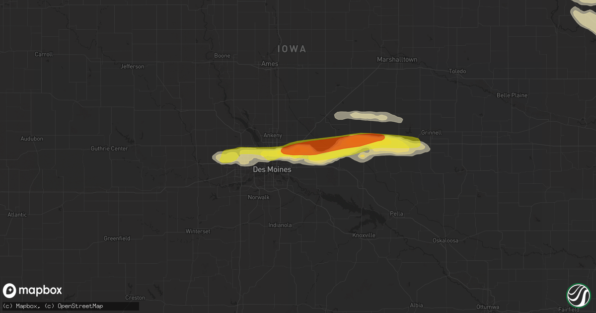
Hail Map in Altoona, IA on June 15, 2017
Get this storm
June 15 map
$229
one time, instant access
Download today. No call, no setup
Keep the $229
Bought the map and want the full workflow? Apply the entire $229 to a subscription within 7 days. None of it is wasted.
Every map, not just this one
This buys you this map. Subscription and you get every map we run, in the markets you choose from a few cities to whole states to nationwide. Plus real-time alerts the moment a storm fires.
Contact data
Name, contact info, occupancy, even credit band for addresses in the footprint. You go from where it hit to who to call.
Become the source they trust
Unlimited branding weather history reports on demand. You already have the documented answer ready for the property owner, and you are the one who showed up with it.
Property data and RoofTrace estimates
Pull up any address you have got, its value and the exact code rules for that jurisdiction, straight from One Click Code. Then RoofTrace estimates the squares, pitch, and roof value, priced the way you price.
Storm reports in Altoona, IA
Altoona, IA
| Date | Description |
|---|---|
| 06/14/201711:16 PM CDT | Lots of quarter to golf ball hail near the highway 65/interstate 80 exit. |
All States Impacted by Hail Map on June 15, 2017
All Cities Impacted by Hail Map on June 15, 2017
- Waynesboro, TN
- Iowa Falls, IA
- Hampton, IA
- Uniontown, AL
- Safford, AL
- Marion Junction, AL
- Bessemer, AL
- Adger, AL
- Sterling, KS
- Nickerson, KS
- Partridge, KS
- Raymond, KS
- Abbyville, KS
- Hutchinson, KS
- Alden, KS
- Isabel, KS
- Medicine Lodge, KS
- Catherine, AL
- Otley, IA
- Ness City, KS
- Saucier, MS
- Diberville, MS
- Biloxi, MS
- Clarendon, TX
- Clanton, AL
- Theodore, AL
- Irvington, AL
- Freedom, OK
- Mooreland, OK
- Morganville, KS
- Clay Center, KS
- Pleasant Grove, AL
- Birmingham, AL
- Mulga, AL
- Gallatin, TN
- Central City, IA
- Independence, IA
- Jesup, IA
- Center Point, IA
- Winthrop, IA
- Walker, IA
- Alburnett, IA
- Coggon, IA
- Brandon, IA
- Rowley, IA
- Lacona, IA
- Tracy, IA
- Chariton, IA
- Knoxville, IA
- Columbia, IA
- Leighton, IA
- Melcher Dallas, IA
- Harvey, IA
- Oskaloosa, IA
- Bussey, IA
- Hamilton, IA
- Liberty, MO
- Kansas City, MO
- Independence, MO
- Hays, KS
- Ellis, KS
- Lead Hill, AR
- Omaha, AR
- Haven, KS
- Gulfport, MS
- Purdin, MO
- Browning, MO
- Linneus, MO
- Monticello, IA
- Hopkinton, IA
- Cascade, IA
- Tulia, TX
- Hoisington, KS
- Woodlawn, TN
- Buckner, MO
- Sibley, MO
- Walnut, IA
- Cumberland, IA
- Griswold, IA
- Bridgewater, IA
- Atlantic, IA
- Massena, IA
- Lewis, IA
- Anita, IA
- Adair, IA
- Wiota, IA
- Goodwater, AL
- Miami, TX
- Pampa, TX
- Hollywood, AL
- Scottsboro, AL
- Pacific Junction, IA
- Alexander City, AL
- Okemah, OK
- Conway Springs, KS
- Wellington, KS
- Mayfield, KS
- Clearwater, KS
- Kingman, KS
- Iuka, KS
- St John, KS
- Stafford, KS
- Pratt, KS
- Larned, KS
- Turon, KS
- Cunningham, KS
- Newton, KS
- Equality, AL
- Gravity, IA
- Gail, TX
- Leavenworth, KS
- Tonganoxie, KS
- Stuart, IA
- Dexter, IA
- Springville, IA
- New Hartford, IA
- Prairieburg, IA
- Anamosa, IA
- Cedar Falls, IA
- Martelle, IA
- Dike, IA
- Cedar Rapids, IA
- Clarksville, IA
- Mount Vernon, IA
- Ackley, IA
- Dumont, IA
- Vinton, IA
- Aplington, IA
- Allison, IA
- Mechanicsville, IA
- Waterloo, IA
- Austinville, IA
- Fairbank, IA
- Palo, IA
- Hiawatha, IA
- Hazleton, IA
- Quasqueton, IA
- Toddville, IA
- Geneva, IA
- Lisbon, IA
- Latimer, IA
- Bradford, IA
- Denver, IA
- Waverly, IA
- Evansdale, IA
- Parkersburg, IA
- Stout, IA
- Marion, IA
- Shellsburg, IA
- Janesville, IA
- Urbana, IA
- Kesley, IA
- Shell Rock, IA
- Coulter, IA
- Robins, IA
- Dunkerton, IA
- Dows, IA
- Attica, KS
- Harper, KS
- Peabody, KS
- Waynesboro, MS
- Summerville, SC
- De Witt, NE
- Adams, NE
- Firth, NE
- Cortland, NE
- Pickrell, NE
- Clatonia, NE
- Ellsworth, KS
- Lorraine, KS
- Beatrice, NE
- Odell, NE
- Columbia, TN
- Santa Fe, TN
- Ovalo, TX
- Tuscola, TX
- Shenandoah, IA
- Keota, IA
- South English, IA
- Harper, IA
- Stevenson, AL
- Fackler, AL
- Marion, AL
- Hillsboro, KS
- Hazelton, KS
- Kiowa, KS
- Hardtner, KS
- Alva, OK
- Hope, KS
- Abilene, KS
- Ripley, MS
- Dumas, MS
- Weir, MS
- Loganville, GA
- Monroe, GA
- Brooklyn, IA
- Hartwick, IA
- Granger, IA
- Winfield, AL
- Clarendon, NC
- Whiteville, NC
- Chadbourn, NC
- Tabor City, NC
- Glasgow, MO
- Gilliam, MO
- Slater, MO
- Tuskegee, AL
- Belmont, MS
- Franklin, TN
- Valley Center, KS
- Wichita, KS
- Sweetwater, TX
- Montgomery, AL
- Prattville, AL
- Green Forest, AR
- Oak Grove, AR
- Byromville, GA
- Bethpage, TN
- Portland, TN
- Midland, TX
- Stanton, TX
- Woodburn, IA
- Hernando, MS
- Wakeeney, KS
- Union, NE
- Percival, IA
- Thurman, IA
- Riverton, IA
- Farragut, IA
- Tabor, IA
- Hamburg, IA
- Nebraska City, NE
- Randolph, IA
- Sidney, IA
- Holdenville, OK
- Sedgwick, KS
- Garden City, TX
- Childersburg, AL
- Benton, KS
- Whitewater, KS
- Eldridge, AL
- Bankston, AL
- Carbon Hill, AL
- Holyrood, KS
- Claflin, KS
- Ellinwood, KS
- Bushton, KS
- Rutherford, TN
- Bradford, TN
- Garden City, KS
- Ingalls, KS
- Cassoday, KS
- Perkinston, MS
- Ackerly, TX
- Levelland, TX
- Big Spring, TX
- Brownfield, TX
- Meadow, TX
- Odonnell, TX
- Lamesa, TX
- Tahoka, TX
- Ropesville, TX
- Sylacauga, AL
- Baxter, TN
- Silver Point, TN
- Smithville, TN
- Sun City, KS
- Lake City, KS
- Glen, MS
- Corinth, MS
- Belvidere, NE
- Carleton, NE
- Hebron, NE
- Alexandria, NE
- Tobias, NE
- Daykin, NE
- Bruning, NE
- Idalou, TX
- Lubbock, TX
- Truro, IA
- Osceola, IA
- New Virginia, IA
- Lucas, IA
- Murray, IA
- Prague, OK
- Stroud, OK
- Sparks, OK
- Waldron, KS
- Anthony, KS
- Coldwater, KS
- Sharon, KS
- Bison, KS
- Town Creek, AL
- Coffeeville, MS
- Tutwiler, MS
- Stockton, KS
- Golden, MS
- Coffeeville, AL
- Jackson, TN
- Senatobia, MS
- Haviland, KS
- Kellogg, IA
- Colfax, IA
- Altoona, IA
- Bondurant, IA
- Mitchellville, IA
- Newton, IA
- Prairie City, IA
- Berwick, IA
- Des Moines, IA
- Pretty Prairie, KS
- Cheney, KS
- Arlington, KS
- Dorrance, KS
- Lucas, KS
- Sylvan Grove, KS
- Norborne, MO
- Lexington, MO
- Dover, MO
- Howard, KS
- Severy, KS
- Fall River, KS
- Coahoma, TX
- Sterling City, TX
- Quitaque, TX
- Claude, TX
- South Haven, KS
- Greenville, MS
- Maryville, MO
- Barnard, MO
- Graham, MO
- Skidmore, MO
- Hale Center, TX
- Olton, TX
- Fieldton, TX
- Marengo, IA
- Urbandale, IA
- Clive, IA
- Eclectic, AL
- Tallassee, AL
- Mobile, AL
- Munising, MI
- Manistique, MI
- Riley, KS
- Manhattan, KS
- Brewton, AL
- Guin, AL
- Hendersonville, TN
- Mount Juliet, TN
- Buckatunna, MS
- Lakeview, TX
- Sumter, SC
- Wamego, KS
- Saint George, KS
- Rossville, KS
- Shattuck, OK
- Leland, MS
- Shelbyville, MO
- Forest, MS
- South Fulton, TN
- Fulton, KY
- Fluvanna, TX
- Leon, KS
- Caledonia, MS
- Murdock, KS
- Marland, OK
- Westminster, SC
- West Blocton, AL
- Franklin, KY
- Scottsville, KY
- Okmulgee, OK
- Beggs, OK
- Blanchard, IA
- Coin, IA
- College Springs, IA
- Shambaugh, IA
- Braddyville, IA
- Essex, IA
- Clarinda, IA
- Rock Port, MO
- Minter City, MS
- Waterloo, AL
- Puryear, TN
- Cottage Grove, TN
- Hopkinsville, KY
- Clarkesville, GA
- Casey, IA
- Fontanelle, IA
- Dallas Center, IA
- Johnston, IA
- Ankeny, IA
- Pleasant Hill, IA
- Grinnell, IA
- Waukee, IA
- Grimes, IA
- Lynnville, IA
- Warrior, AL
- Moulton, AL
- Cleveland, SC
- Mystic, IA
- Plano, IA
- Centerville, IA
- Windsor Heights, IA
- Monroe, IA
- Notasulga, AL
- Lelia Lake, TX
- South Wayne, WI
- Auburn, KS
- Topeka, KS
- Hamilton, MS
- Niota, IL
- Grand Marais, MI
- Montrose, IA
- Atmore, AL
- Sandy Ridge, NC
- Fargo, OK
- Paris, MO
- Shelbina, MO
- Rockford, AL
- Derby, KS
- Booth, AL
- Autaugaville, AL
- Bedford, IA
- Albany, MO
- Harrison, AR
- Fairfield, AL
- Adamsville, AL
- Dolomite, AL
- Tell, TX
- Cee Vee, TX
- Paducah, TX
- Childress, TX
- Turkey, TX
- Tuscaloosa, AL
- Fosters, AL
- Ladson, SC
- Charleston, SC
- Afton, IA
- Creston, IA
- Leola, AR
- Eureka, KS
- Tampa, FL
- Polk City, IA
- Dunbar, NE
- Ransom, KS
- Arnold, KS
- Utica, KS
- Dalton, GA
- Brierfield, AL
- Woodstock, AL
- White Hall, IL
- Roodhouse, IL
- Viola, KS
- Pleasantville, IA
- Hartford, IA
- Swan, IA
- Mount Airy, GA
- Bolton, NC
- Springfield, TN
- Cedar Hill, TN
- Mounds, OK
- Sapulpa, OK
- Colorado City, TX
- Belle Plaine, IA
- Snyder, TX
- Ryan, IA
- Masonville, IA
- Manchester, IA
- Farmington, KY
- Mayfield, KY
- Hawk Point, MO
- Middlebury, IN
- Bristol, IN
- Paxico, KS
- Macksburg, IA
- Sutter, IL
- West Point, IL
- Winterset, IA
- De Soto, IA
- Earlham, IA
- Greenfield, IA
- Cumming, IA
- Norwalk, IA
- Van Meter, IA
- Menlo, IA
- Shubuta, MS
- Wetumka, OK
- Weleetka, OK
- Molena, GA
- Thomaston, GA
- Brent, AL
- Chase, KS
- Georgetown, SC
- Beeler, KS
- Hudson, KS
- Carthage, MS
- Walnut Grove, MS
- Mcpherson, KS
- Amazonia, MO
- Savannah, MO
- Longton, KS
- Fredonia, KS
- Elk City, KS
- Marquette, KS
- Pella, IA
- Hedley, TX
- Canadian, TX
- Depew, OK
- Crump, TN
- Adamsville, TN
- Green Cove Springs, FL
- Lauderdale, MS
- Enid, MS
- Gadsden, AL
- Hancock, MI
- Calumet, MI
- Lyons, KS
- Cimarron, KS
- Meeker, OK
- Chandler, OK
- Schoenchen, KS
- Princeton, MO
- Ridgeway, MO
- Baxter, IA
- Tescott, KS
- Fulton, MS
- Mantachie, MS
- Randolph, MS
- Houlka, MS
- Prairie Du Chien, WI
- Hamilton, KS
- Aspermont, TX
- Sledge, MS
- Clifton, KS
- Douglas, NE
- Sterling, NE
- Hayden, AL
- Cleveland, AL
- Gypsum, KS
- Manchester, TN
- Abbeville, MS
- Latham, KS
- McLouth, KS
- Courtland, AL
- Burdick, KS
- Herington, KS
- Lineville, AL
- Talladega, AL
- Ashland, AL
- Millerville, AL
- Russell, KS
- Eskridge, KS
- Fairfax, OK
- Ponca City, OK
- Ralston, OK
- Plymouth, NE
- Western, NE
- New Middletown, OH
- New Springfield, OH
- North Lima, OH
- Petersburg, OH
- Youngstown, OH
- Columbiana, OH
- Gentry, MO
- Great Bend, KS
- Collyer, KS
- Otis, KS
- Rush Center, KS
- McCracken, KS
- Olmitz, KS
- Liebenthal, KS
- Pfeifer, KS
- Ogallah, KS
- La Crosse, KS
- Pawnee Rock, KS
- Albert, KS
- Gorham, KS
- Coldwater, MS
- Gautier, MS
- Blairstown, IA
- Luzerne, IA
- Goddard, KS
- Marion, SC
- Collinsville, MS
- Winfield, KS
- Northboro, IA
- Westboro, MO
- Waverly, AL
- Avoca, NE
- Weeping Water, NE
- Nehawka, NE
- Assaria, KS
- Wadley, GA
- Malvern, IA
- Macedonia, IA
- Red Oak, IA
- Henderson, IA
- Elliott, IA
- Carson, IA
- Hastings, IA
- Emerson, IA
- Silver City, IA
- Henryetta, OK
- Salem, VA
- Catawba, VA
- Victoria, KS
- Lampe, MO
- Blue Eye, MO
- Hickory, KY
- Peru, KS
- Bells, TN
- Burnsville, MS
- Norwich, KS
- Vancleave, MS
- Muskogee, OK
- Elko, GA
- Mcconnell Afb, KS
- Greenwich, KS
- Elbing, KS
- Andover, KS
- Hesston, KS
- Peck, KS
- Argonia, KS
- Garden Plain, KS
- Rose Hill, KS
- Moundridge, KS
- Potwin, KS
- Braman, OK
- Milton, KS
- Haysville, KS
- Walton, KS
- Macksville, KS
- Goessel, KS
- Kechi, KS
- Burns, KS
- Canton, KS
- Chelsea, IA
- Tama, IA
- Brookfield, MO
- Little River, KS
- Geneseo, KS
- Hilliard, FL
- Iuka, MS
- McGehee, AR
- Lebanon, TN
- Goose Creek, SC
- Memphis, TX
- Monticello, AR
- Dermott, AR
- Swanton, NE
- Strong City, KS
- Elmdale, KS
- Thomasville, AL
- Silas, AL
- Iowa City, IA
- Wellman, IA
- Kalona, IA
- Riverside, IA
- Blue Springs, MS
- Berry, AL
- Northport, AL
- North Charleston, SC
- New Cambria, MO
- Ethel, MO
- Independence, KS
- Neodesha, KS
- Udall, KS
- Ruleville, MS
- Hanahan, SC
- Kellyton, AL
- Lindsborg, KS
- Windom, KS
- Belvue, KS
- Mullins, SC
- Irwinton, GA
- Shawnee, OK
- Guntown, MS
- Saltillo, MS
- Madison, KS
- Westmoreland, KS
- Sheffield, IL
- Oakland, MS
- Grenada, MS
- Seminole, OK
- Shallowater, TX
- Zolfo Springs, FL
- Carrollton, MS
- Gage, OK
- Batesville, MS
- Courtland, MS
- Myrtle, MS
- Sturgeon, MO
- Clark, MO
- Kosciusko, MS
- Finger, TN
- Bethel Springs, TN
- Elrod, AL
- Echola, AL
- Buhl, AL
- Helena, AL
- Memphis, MI
- Folkston, GA
- Hickory, PA
- Canonsburg, PA
- Westland, PA
- Washington, PA
- McDonald, PA
- Minneapolis, KS
- Longford, KS
- Seymour, TX
- Williston, TN
- Saint Marys, KS
- Olsburg, KS
- Emmett, KS
- Onaga, KS
- Hohenwald, TN
- Summertown, TN
- Hamlin, TX
- Louisville, AL
- Clio, AL
- Buffalo, OK
- Delphos, KS
- Miltonvale, KS
- Sawyer, KS
- Ramer, AL
- Lenox, IA
- Augusta, KS
- Ridgeway, VA
- Stoneville, NC
- Emelle, AL
- Coker, AL
- Ralph, AL
- De Witt, MO
- Eatonton, GA
- Woodston, KS
- Riverside, MO
- Kansas City, KS
- Plainfield, IA
- Murray, NE
- Salina, KS
- Rose Hill, IA
- Amherst, TX
- Oakman, AL
- Five Points, TN
- Leoma, TN
- Minor Hill, TN
- Middleburg, FL
- Demopolis, AL
- Nodaway, IA
- Holly Springs, MS
- Kathleen, GA
- Pawnee, OK
- Freeport, KS
- Danville, KS
- Oakland, TN
- Davisboro, GA
- Warthen, GA
- Sandersville, GA
- Seale, AL
- Tullahoma, TN
- Lawrence, KS
- Pontotoc, MS
- South Pittsburg, TN
- Maple Hill, KS
- Stanton, IA
- Villisca, IA
- Huntsville, AL
- Wakefield, KS
- Orrick, MO
- Boley, OK
- Vincent, AL
- Cropwell, AL
- Selmer, TN
- Michie, TN
- Enterprise, KS
- De Kalb, MS
- Millington, TN
- Alpine, AL
- Huntsville, MO
- Clifton Hill, MO
- Holcomb, MS
- Charleston, MS
- Philipp, MS
- Hallsville, MO
- Centralia, MO
- Adel, IA
- Arlington, TN
- Eads, TN
- Lincoln, KS
- Brookville, KS
- New Cambria, KS
- Beverly, KS
- Solomon, KS
- Tampico, IL
- Rotan, TX
- Emden, MO
- Ariton, AL
- Wentworth, MO
- Pierce City, MO
- Monett, MO
- Corder, MO
- Waverly, MO
- Sharon, OK
- Mountainburg, AR
- Wetmore, MI
- Rumely, MI
- Au Train, MI
- Deerton, MI
- Trenary, MI
- Shingleton, MI
- Chatham, MI
- Falun, KS
- Quitman, MS
- Adolphus, KY
- Pine Hill, AL
- Alberta, AL
- Thomaston, AL
- Magnolia, AL
- Arlington, AL
- Eutaw, AL
- Mount Hope, KS
- Thorsby, AL
- Jemison, AL
- Lamoni, IA
- Eagleville, MO
- Blythedale, MO
- Lower Peach Tree, AL
- Atkins, IA
- Newhall, IA
- Wilson, KS
- Mayodan, NC
- Trent, TX
- Merkel, TX
- Oxford, KS
- Burrton, KS
- Philadelphia, MS
- Perry, GA
- Unadilla, GA
- Montezuma, GA
- Maize, KS
- Council, NC
- Lake Waccamaw, NC
- Morris, OK
- Dadeville, AL
- Camp Hill, AL
- Lincoln, AL
- Eastaboga, AL
- Wadley, AL
- Cedar Grove, TN
- New Florence, MO
- Montgomery City, MO
- Conception Junction, MO
- Guilford, MO
- Winnabow, NC
- Clifton, TN
- Elk Falls, KS
- Moline, KS
- Double Springs, AL
- Henderson, TN
- Fayetteville, TN
- Frisco City, AL
- Monroeville, AL
- Repton, AL
- McCalla, AL
- Lexington, TN
- Huron, TN
- Webster, IA
- Lone Tree, IA
- Sigourney, IA
- Sparta, TN
- Bristow, IA
- Crenshaw, MS
- Riner, VA
- Brevard, NC
- Madison Heights, VA
- Lynchburg, VA
- Dixons Mills, AL
- Sweet Water, AL
- Pickering, MO
- Hopkins, MO
- Clearmont, MO
- Walnut, MS
- Novinger, MO
- Kirksville, MO
- Elmwood, NE
- Cainsville, MO
- Russell, IA
- Williamson, IA
- Luray, KS
- Miami, MO
- Malta Bend, MO
- Tuskegee Institute, AL
- Jansen, NE
- Bennett, IA
- Tipton, IA
- Clarence, IA
- Talmage, NE
- Colwich, KS
- Andale, KS
- Hillview, IL
- Plevna, KS
- Galva, KS
- Moberly, MO
- Century, FL
- McDavid, FL
- Daviston, AL
- Cragford, AL
- Wagarville, AL
- Lovilia, IA
- Albia, IA
- Antioch, TN
- Lutts, TN
- Martin, TN
- Fruitdale, AL
- Leakesville, MS
- State Line, MS
- Vinegar Bend, AL
- Ethel, MS
- Barnsdall, OK
- Tupelo, MS
- Thomson, IL
- Shell Knob, MO
- Alpena, AR
- Berryville, AR
- Cornersville, TN
- Pulaski, TN
- Maramec, OK
- Woodward, OK
- Follett, TX
- Fort Supply, OK
- Redfield, IA
- Mineola, IA
- Glenwood, IA
- Lincolnville, KS
- Monroe, VA
- Memphis, TN
- Hermleigh, TX
- Louisville, GA
- Hancock, IA
- Oakland, IA
- Vardaman, MS
- Houston, MS
- Long Grove, IA
- Dixon, IA
- Eldridge, IA
- Davenport, IA
- Walcott, IA
- Donahue, IA
- Orrum, NC
- Lupton, MI
- Hale, MI
- Cedar Vale, KS
- McBee, SC
- Pawhuska, OK
- Okolona, MS
- Gordo, AL
- Fountain Run, KY
- McCaulley, TX
- Plattsmouth, NE
- Bonaire, GA
- Castleberry, AL
- Alta Vista, KS
- Tremont, MS
- Indianola, IA
- Beacon, IA
- Thayer, IA
- Woodbine, KS
- Oskaloosa, KS
- Linn, KS
- Haddam, KS
- Hardaway, AL
- Imogene, IA
- Fleming Island, FL
- Jacksonville, FL
- Orange Park, FL
- Berryton, KS
- Atlanta, KS
- Nauvoo, AL
- Lancaster, TN
- Buffalo Valley, TN
- Novelty, MO
- White City, KS
- Carrollton, AL
- Sterrett, AL
- Talbotton, GA
- Box Springs, GA
- Grand Bay, AL
- Morton, MS
- Pelahatchie, MS
- Silverton, TX
- New Castle, VA
- Union Springs, AL
- Fort Davis, AL
- White House, TN
- Carolina Beach, NC
- Wilmington, NC
- Jasper, AL
- Leland, NC
- Princeton, IL
- Baldwyn, MS
- Diller, NE
- Heidelberg, MS
- Huntingdon, TN
- Westport, TN
- Hamilton, AL
- Macon, MS
- Hardy, VA
- Blackwell, TX
- Sedan, KS
- Grenola, KS
- West Des Moines, IA
- Hope Hull, AL
- Bladenboro, NC
- Callao, MO
- Bevier, MO
- Halls, TN
- Spivey, KS
- Dighton, KS
- Trinity, AL
- Quail, TX
- Glenwood, MO
- Livonia, MO
- Sheridan, MO
- Grant City, MO
- Worth, MO
- Blockton, IA
- Redding, IA
- Midway, AL
- Wilsey, KS
- Pine Hall, NC
- Madison, NC
- Walnut Cove, NC
- Cedar, IA
- Kennett, MO
- Newberry, MI
- Metropolis, IL
- Sardis, MS
- Osage, OK
- Aberdeen, MS
- Plainview, TX
- Cottontown, TN
- Tillar, AR
- Woodville, AL
- Grant, AL
- Faunsdale, AL
- Waterford, MS
- Tunnel Hill, GA
- Rocky Face, GA
- Spickard, MO
- Newkirk, OK
- Auburn, AL
- Mount Pleasant, TN
- Paris, TN
- Arab, AL
- Guntersville, AL
- Gallion, AL
- Shannon City, IA
- Richmond, MO
- Nolan, TX
- Henrietta, MO
- Union City, TN
- Nesbit, MS
- Byhalia, MS
- Olive Branch, MS
- Easton, KS
- Atchison, KS
- Clinton, KY
- Fancy Farm, KY
- Mound City, MO
- Oregon, MO
- Maitland, MO
- Troy, AL
- Fitzpatrick, AL
- Washington, IA
- Saint George, GA
- Wyanet, IL
- Winchester, KS
- Savanna, IL
- Elizabeth, IL
- Mount Carroll, IL
- Elberta, AL
- Oak Grove, KY
- Lake Village, AR
- Flatgap, KY
- West Liberty, KY
- Symsonia, KY
- Boaz, KY
- Estillfork, AL
- Matfield Green, KS
- Nettleton, MS
- Smithville, MS
- Fairbury, NE
- Fairfax, IA
- Amana, IA
- Norway, IA
- Chatom, AL
- Tibbie, AL
- Deer Park, AL
- Greenfield, TN
- Fort Campbell, KY
- Pope, MS
- Mount Hope, AL
- Parrish, AL
- Cordova, AL
- Ocean Springs, MS
- Blackwell, OK
- Douglass, KS
- Morrowville, KS
- Meriden, KS
- Hoyt, KS
- Maywood, MO
- Durham, MO
- Harpersville, AL
- Pell City, AL
- Denver, MO
- Livingston, AL
- Quinton, AL
- Mount Ayr, IA
- Hatfield, MO
- Dexter, KS
- Counce, TN
- Emporia, KS
- Danville, AL
- Aurora, KS
- Bennington, KS
- Wrens, GA
- La Plata, MO
- Rising Star, TX
- Cisco, TX
- Caldwell, KS
- Thaxton, MS
- Higginsville, MO
- Hardin, MO
- Creekside, PA
- Lewisburg, TN
- Bucklin, MO
- Christiansburg, VA
- Sedalia, KY
- Bolivia, NC
- Shannon, MS
- New Boston, MO
- Allenton, MI
- Porter, OK
- Sylvia, KS
- Solon, IA
- North Liberty, IA
- Carthage, MO
- Eddyville, IA
- Hatchechubbee, AL
- Jacksons Gap, AL
- El Dorado, KS
- Walnut, IL
- Lenexa, KS
- Marion, KS
- Friendship, TN
- Hays, NC
- Olpe, KS
- Bettendorf, IA
- Parnell, MO
- Roscoe, TX
- Carlisle, IA
- Bruce, MS
- Pittsboro, MS
- Decaturville, TN
- Sardis, TN
- Scotts Hill, TN
- Delia, KS
- Whittemore, MI
- Joelton, TN
- Goodlettsville, TN
- Greenbrier, TN
- Pleasant View, TN
- Mathews, AL
- Halstead, KS
- Tampa, KS
- Roxbury, KS
- Ramona, KS
- Inman, KS
- Buhler, KS
- Sherwood, TN
- Burlington, OK
- Montevallo, AL
- Vance, AL
- Brookwood, AL
- Alabaster, AL
- Hermitage, TN
- Nashville, TN
- Rochester Mills, PA
- Punxsutawney, PA
- New Hampton, MO
- Coats, KS
- Stephens, GA
- Union Point, GA
- Saltillo, TN
- Maple City, KS
- Porterville, MS
- Fremont, IA
- Gibson, GA
- Mitchell, GA
- Mantee, MS
- Weiner, AR
- Amagon, AR
- Fisher, AR
- Higbee, MO
- Deatsville, AL
- Chester, AR
- Prairie, MS
- Sarah, MS
- Coatsville, MO
- Mingo, IA
- Union, SC
- Bartow, GA
- Alvo, NE
- Cherokee, AL
- Durham, KS
- Lehigh, KS
- Stanwood, IA
- Winters, TX
- Tripoli, IA
- Sumner, IA
- Gridley, KS
- Belle Plaine, KS
- Andersonville, GA
- Americus, GA
- Bunker Hill, KS
- Greenwood, MS
- Ashland City, TN
- Haleyville, AL
- Belvidere, TN
- Winchester, TN
- Summerdale, AL
- Foley, AL
- Trenton, MO
- Gilman City, MO
- Jamesport, MO
- Sarcoxie, MO
- Maben, MS
- Barry, IL
- Spring Hill, TN
- Thompsons Station, TN
- Brownsville, TN
- Millry, AL
- Marceline, MO
- Hominy, OK
- Cleveland, OK
- Taft, TN
- Victor, IA
- Ladora, IA
- Alma, MO
- Blackburn, MO
- Lorenzo, TX
- Ralls, TX
- Slaton, TX
- Hartselle, AL
- Swainsboro, GA
- Kite, GA
- Alma, KS
- Water Valley, MS
- Jennings, OK
- Maxwell, IA
- Cambridge, IA
- Lecompton, KS
- Vernon, AL
- Sulligent, AL
- Big Rock, VA
- Haysi, VA
- Ira, TX
- Westbrook, TX
- Burbank, OK
- La Porte City, IA
- Dewar, IA
- Alden, IA
- Delhi, IA
- Aurora, IA
- Raymond, IA
- Supply, NC
- Benoit, MS
- Cottonwood Falls, KS
- Toomsboro, GA
- Westpoint, TN
- Iron City, TN
- Ocklawaha, FL
- Meridian, MS
- Barnard, KS
- Bellflower, MO
- New Sharon, IA
- Mcminnville, TN
- Burden, KS
- Westmoreland, TN
- Meridianville, AL
- Ragland, AL
- Decatur, GA
- Ellenwood, GA
- Conley, GA
- Elmo, MO
- Burlington Junction, MO
- Tarkio, MO
- Yorktown, IA
- Bixby, OK
- Linden, TN
- Ethelsville, AL
- Reform, AL
- Bazine, KS
- Luray, TN
- Wayland, MO
- Argyle, IA
- Reeds, MO
- Milan, MO
- Atlanta, MO
- Elizabethton, TN
- Enterprise, MS
- Stonewall, MS
- Centreville, AL
- Florence, SC
- Spencer, VA
- Harrisburg, MO
- Hampton, IL
- Pleasant Valley, IA
- Robertsdale, AL
- Excelsior Springs, MO
- Toronto, KS
- Camden, MO
- Wilber, NE
- Burr, NE
- Cook, NE
- Gilead, NE
- Brownell, KS
- Plainville, KS
- Quinter, KS
- Green, KS
- Clyde, KS
- Agenda, KS
- Dodge City, KS
- Jetmore, KS
- Byers, KS
- Sudan, TX
- Littlefield, TX
- Quanah, TX
- Gilbertville, IA
- Greene, IA
- Prole, IA
- Hills, IA
- Latta, SC
- Timmonsville, SC
- Darlington, SC
- Lamar, SC


