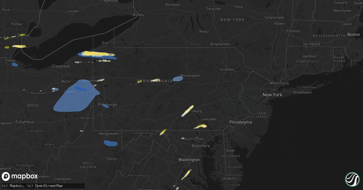
Hail Map in Pennsylvania on June 14, 2026
Get this storm
June 14 map
$229
one time, instant access
Download today. No call, no setup
Keep the $229
Bought the map and want the full workflow? Apply the entire $229 to a subscription within 7 days. None of it is wasted.
Every map, not just this one
This buys you this map. Subscription and you get every map we run, in the markets you choose from a few cities to whole states to nationwide. Plus real-time alerts the moment a storm fires.
Contact data
Name, contact info, occupancy, even credit band for addresses in the footprint. You go from where it hit to who to call.
Become the source they trust
Unlimited branding weather history reports on demand. You already have the documented answer ready for the property owner, and you are the one who showed up with it.
Property data and RoofTrace estimates
Pull up any address you have got, its value and the exact code rules for that jurisdiction, straight from One Click Code. Then RoofTrace estimates the squares, pitch, and roof value, priced the way you price.
Storm reports in Pennsylvania
Pennsylvania
| Date | Description |
|---|---|
| 06/14/20266:57 PM CDT | Down trees. |
| 06/14/20266:55 PM CDT | Multiple trees down on bedford street. |
| 06/14/20266:37 PM CDT | Down trees. |
| 06/14/20266:35 PM CDT | Corrects previous tstm wnd dmg report from 2 sse pine glen. Trees down on road hit wires with reports of a roof lifted off of a residence on the 800 block of pine glen |
| 06/14/20266:35 PM CDT | Trees down on road hit wires. |
| 06/14/20266:30 PM CDT | Multiple trees down in halifax township peters mountain pa 147 near million dollar rd. |
| 06/14/20266:29 PM CDT | Tree down onto a house in middle paxton township... No injuries reported. |
| 06/14/20266:26 PM CDT | Tree down on peters mountain road. |
| 06/14/20266:25 PM CDT | Tree down on carolyn street. |
| 06/14/20266:24 PM CDT | Report from mping: quarter |
| 06/14/20266:21 PM CDT | Seven trees down... Pea sized hail. |
| 06/14/20266:20 PM CDT | Corrects time from previous tstm wnd dmg report from 2 w marysville. |
| 06/14/20266:19 PM CDT | Down trees. |
| 06/14/20266:18 PM CDT | Tree down on cherry springs road. |
| 06/14/20266:12 PM CDT | Down power lines. |
| 06/14/20266:08 PM CDT | A local report indicates 1.00 inch wind near 2 E Carlisle |
| 06/14/20266:08 PM CDT | Phone lines and trees down along with 1 inch hail. |
| 06/14/20266:07 PM CDT | Multiple trees down blocking roadway ridge road. |
| 06/14/20266:04 PM CDT | Multiple trees down by upper bark shanty road and state route 872. |
| 06/14/20266:02 PM CDT | Down wires. |
| 06/14/20266:00 PM CDT | Several trees down near valley rd and rye brubeck circle. |
| 06/14/20265:55 PM CDT | Down trees. |
| 06/14/20265:53 PM CDT | Tree down near route 6 in liberty township. |
| 06/14/20265:53 PM CDT | Trees and wires down. |
| 06/14/20265:47 PM CDT | Tree down on road near westinghouse bridge. Photo provided. |
| 06/14/20265:45 PM CDT | Tree down blocking road near indian creek and north branch road. |
| 06/14/20265:37 PM CDT | Trees down on wires on route 6. |
| 06/14/20265:35 PM CDT | Wires down on church street. |
| 06/14/20265:35 PM CDT | Trees and wires down. |
| 06/14/20265:30 PM CDT | A local report indicates 60 MPH wind near Carnegie |
| 06/14/20265:30 PM CDT | Large tree down across brighton road near giant eagle. Time estimated via radar. |
| 06/14/20265:29 PM CDT | Trees down. |
| 06/14/20265:27 PM CDT | Tree down on williamson road. |
| 06/14/20265:26 PM CDT | Down trees. |
| 06/14/20265:25 PM CDT | Large branches down. |
| 06/14/20265:24 PM CDT | Tree down near us route 219. |
| 06/14/20265:16 PM CDT | Trees down on chestnut street. |
| 06/14/20265:15 PM CDT | Large branches down. |
| 06/14/20265:15 PM CDT | Tree down near sedgwick street and state route 321. |
| 06/14/20265:10 PM CDT | Large down trees. |
| 06/14/20265:09 PM CDT | Down trees. |
| 06/14/20265:04 PM CDT | Down wires. |
| 06/14/20265:01 PM CDT | Tree down near water street and south hillside ave tree down. |
| 06/14/20265:00 PM CDT | Trees/wires down on bain rd. |
| 06/14/20264:59 PM CDT | Down trees. |
| 06/14/20264:56 PM CDT | Tree down blocking roadway. |
| 06/14/20264:52 PM CDT | Numerous down trees. |
| 06/14/20264:52 PM CDT | A few snapped trees with littered branches at the intersection of euclid road and muddy creek drive. Time estimated via radar. |
| 06/14/20264:51 PM CDT | Numerous down trees. |
| 06/14/20264:50 PM CDT | Down large branches. |
| 06/14/20264:47 PM CDT | Down power lines. |
| 06/14/20264:46 PM CDT | Down trees. |
| 06/14/20264:44 PM CDT | Corrects previous tornado report from ambridge. Down trees and damage to an above ground pool. |
| 06/14/20264:44 PM CDT | Down trees and damage to an above ground pool. |
| 06/14/20264:44 PM CDT | Down trees. |
| 06/14/20264:44 PM CDT | Down trees. |
| 06/14/20264:40 PM CDT | Down power lines and trees. |
| 06/14/20264:40 PM CDT | Barn roof ripped off and walls torn down. Time estimated via radar. |
| 06/14/20264:40 PM CDT | Tree down on house in warren pa. |
| 06/14/20264:40 PM CDT | Trees and wires down on 301 west street. |
| 06/14/20264:40 PM CDT | Down wires. |
| 06/14/20264:40 PM CDT | Down trees. |
| 06/14/20264:36 PM CDT | Down wires. |
| 06/14/20264:27 PM CDT | Down trees. |
| 06/14/20264:25 PM CDT | Down trees. |
| 06/14/20264:25 PM CDT | Trees and wires down near intersection of pa route 27 and selkirk road. |
| 06/14/20264:25 PM CDT | Trees down near intersection of route 127 and jimmy lane. |
| 06/14/20264:25 PM CDT | Trees on wires along pa 872. |
| 06/14/20264:23 PM CDT | Down wires. |
| 06/14/20264:17 PM CDT | Down trees. |
| 06/14/20264:15 PM CDT | Several trees down and some trunks snapped along stone springhouse road and breedtown road. Time estimated via radar. |
| 06/14/20264:12 PM CDT | Trees/wires down. |
| 06/14/20264:11 PM CDT | Down trees. |
| 06/14/20264:10 PM CDT | Down trees. |
| 06/14/20264:08 PM CDT | Down trees. |
| 06/14/20264:05 PM CDT | Down trees. |
| 06/14/20264:03 PM CDT | Tree blocking roadway on watson highway. |
| 06/14/20263:56 PM CDT | Multiple trees down. |
| 06/14/20263:55 PM CDT | Trees/power lines down. |
| 06/14/20263:55 PM CDT | Trees/power lines down. |
| 06/14/20263:54 PM CDT | Down wires. |
| 06/14/20263:45 PM CDT | Couple of trees down. |
| 06/14/20263:41 PM CDT | A local report indicates 1.25 inch wind near Cambridge Springs |
| 06/14/20263:41 PM CDT | Report of trees down on state route 301 north of anita. Likely tornado damage. Time estimated from radar. |
| 06/14/20263:41 PM CDT | Trees/power lines downed. |
| 06/14/20263:37 PM CDT | Report of a tornado on the ground near steves lane in ringgold township. |
| 06/14/20263:37 PM CDT | Trees/power lines downed. |
| 06/14/20263:33 PM CDT | A local report indicates 60 MPH wind near Union City |
| 06/14/20263:27 PM CDT | 2 large trees down north of sagertown blocking route 19. |
| 06/14/20263:23 PM CDT | Lots of tree limbs down in the area. |
| 06/14/20263:22 PM CDT | Corrects previous tornado report from 2 sw worthville. Report of a tornado on the ground near steves lane in ringgold township. |
| 06/14/20263:16 PM CDT | Large hickory tree blown down along with several tree limbs and swirling winds. Hail to half dollar size hail. Possible tornado. |
| 06/14/20263:10 PM CDT | Multiple trees and power lines down across the area. |
| 06/13/202610:08 PM CDT | Trees down in falls township... Pa. Time estimated from radar. |
| 06/13/202610:06 PM CDT | Downed tree on general mercer road... Resulting in a road closure. Time estimated from radar. |
| 06/13/20269:54 PM CDT | Trees down around doylestown. Time estimated from radar. |
| 06/13/20269:40 PM CDT | Delayed report...trained spotter sent in photos of trees down and uprooted along upper state road along the side streets of blackburn drive and grove circle. Est time 1 |
| 06/13/20269:36 PM CDT | Trees down along lincoln drive near gypsy ln with a lane restriction. Time estimated from radar. |
| 06/13/20269:32 PM CDT | Delayed report...public sent in photos on facebook of trees down in parking lot near intersection of ridge ave and bells mill rd. Time estimated. |
| 06/13/20269:29 PM CDT | Reports of wires down around broomall. Time estimated from radar. |
| 06/13/20269:27 PM CDT | Trees down around radnor township. Time estimated from radar. |
| 06/13/20269:25 PM CDT | Multiple reports of wires down around ridley park and prospect park in delaware county. Time estimated from radar. |
| 06/13/20269:23 PM CDT | Trees and wires down around marple township. Time estimated from radar. |
| 06/13/20269:20 PM CDT | Several reports of wires down around media. Time estimated from radar. |
| 06/13/20268:15 PM CDT | Wires down. Time based on radar. |
| 06/13/20268:13 PM CDT | Wires down and arcing in lewis township. |
| 06/13/20268:09 PM CDT | Tree down on reynolds st near rutter ave. |
| 06/13/20267:50 PM CDT | Trees down... Time based on radar. |
| 06/13/20267:46 PM CDT | Trees and wires down on west village drive. |
| 06/13/20267:45 PM CDT | Wires down on muddle creek forks road. |
| 06/13/20267:45 PM CDT | Wires down. |
| 06/13/20267:41 PM CDT | Tree down on cement hollow road. |
| 06/13/20267:39 PM CDT | Tree down on tomhicken rd near prospect rd. |
| 06/13/20267:38 PM CDT | Tree down on wire. |
| 06/13/20267:36 PM CDT | Two trees down on pine creek ave. |
| 06/13/20267:31 PM CDT | Trees down... Time based on radar. |
| 06/13/20267:29 PM CDT | 50kt wind gust at klhv. |
| 06/13/20267:26 PM CDT | Corrects previous tstm wnd dmg report from 3 nw stonybrook. Tree down on deininger road. |
| 06/13/20267:26 PM CDT | Tree down on deininger road. |
| 06/13/20267:24 PM CDT | Multiple trees down in freedom township. |
| 06/13/20267:23 PM CDT | Trees down... Time based on radar. |
| 06/13/20267:19 PM CDT | Large tree down blocking the roadway in blue knob state park... Near burnt house picnic area. |
| 06/13/20267:17 PM CDT | Trees and wires down on union church road. |
| 06/13/20267:15 PM CDT | Trees down on wires... Time based on radar. |
| 06/13/20267:04 PM CDT | Tree down on car on east howard street. |
| 06/13/20267:00 PM CDT | Tree down. |
All States Impacted by Hail Map on June 14, 2026
Cities Impacted by Hail Map on June 14, 2026
- Ann Arbor, MI
- Ypsilanti, MI
- Dearborn, MI
- Detroit, MI
- Dundee, MI
- Milan, MI
- Maybee, MI
- Carleton, MI
- South Rockwood, MI
- Newport, MI
- Rockwood, MI
- Wayne, MI
- Westland, MI
- Walhalla, SC
- Tamassee, SC
- Salem, SC
- Six Mile, SC
- Sunset, SC
- Pickens, SC
- Canton, MI
- Inkster, MI
- Garden City, MI
- Galivants Ferry, SC
- Millbury, OH
- Curtice, OH
- Northwood, OH
- Genoa, OH
- Clay Center, OH
- Graytown, OH
- Martin, OH
- Woodville, OH
- Elmore, OH
- Jacksonville, NC
- Jesup, GA
- Maysville, NC
- Georgetown, SC
- Murrells Inlet, SC
- Myrtle Beach, SC
- Bucyrus, OH
- Van Horn, TX
- Bowersville, GA
- Canon, GA
- Geneva, OH
- Sedona, AZ
- Mansfield, OH
- Ashland, OH
- Holly Ridge, NC
- Ashtabula, OH
- Austinburg, OH
- Jefferson, OH
- Bainbridge, GA
- Climax, GA
- Belhaven, NC
- Aurora, NC
- Wooster, OH
- Whigham, GA
- Scranton, NC
- Blounts Creek, NC
- Montville, OH
- Chardon, OH
- Madison, OH
- Orrville, OH
- Sterling, OH
- Burbank, OH
- Smithville, OH
- Creswell, NC
- Windsor, OH
- Rome, OH
- Bath, NC
- Conneaut, OH
- Kingsville, OH
- Springboro, PA
- Albion, PA
- Pierpont, OH
- West Springfield, PA
- Live Oak, FL
- Columbia, NC
- Edinboro, PA
- Conneautville, PA
- Clinton, OH
- Pinetown, NC
- Willard, NC
- Burgaw, NC
- Andover, OH
- Dorset, OH
- Ringgold, PA
- Timblin, PA
- Punxsutawney, PA
- Goldsmith, TX
- Notrees, TX
- Clinton, NC
- Cambridge Springs, PA
- Venango, PA
- Linesville, PA
- Saegertown, PA
- Dillwyn, VA
- Melbourne, FL
- Anita, PA
- Reynoldsville, PA
- Meadville, PA
- Waterford, PA
- Conneaut Lake, PA
- Winslow, AZ
- Union City, PA
- Kenansville, FL
- Du Bois, PA
- Centerville, PA
- Williams, AZ
- Guys Mills, PA
- Sykesville, PA
- Spartansburg, PA
- Wagener, SC
- Enon Valley, PA
- New Castle, PA
- Bessemer, PA
- New Wilmington, PA
- Volant, PA
- Odessa, TX
- Mercer, PA
- Grove City, PA
- Clearfield, PA
- Claxton, GA
- Collins, GA
- Rio Rancho, NM
- Metter, GA
- Cobbtown, GA
- Rootstown, OH
- North Lima, OH
- Lake Milton, OH
- Newton Falls, OH
- Wilmot, OH
- Amsterdam, OH
- Wellsville, OH
- New Philadelphia, OH
- Beloit, OH
- Mineral City, OH
- Magnolia, OH
- Navarre, OH
- Alliance, OH
- Millersburg, OH
- Hanoverton, OH
- Waynesburg, OH
- Stone Creek, OH
- Baltic, OH
- Lowellville, OH
- Sebring, OH
- Newcomerstown, OH
- Bolivar, OH
- Canton, OH
- East Sparta, OH
- Beaver, PA
- Bloomingdale, OH
- Fresno, OH
- Negley, OH
- Somerdale, OH
- Stratton, OH
- Brewster, OH
- Salem, OH
- Strasburg, OH
- Minerva, OH
- Scio, OH
- Hopedale, OH
- Mechanicstown, OH
- Dover, OH
- East Liverpool, OH
- Louisville, OH
- Leetonia, OH
- East Springfield, OH
- West Lafayette, OH
- Kensington, OH
- Struthers, OH
- Gnadenhutten, OH
- Freeport, OH
- Salineville, OH
- Jewett, OH
- North Benton, OH
- Lisbon, OH
- Beach City, OH
- Homeworth, OH
- North Jackson, OH
- Tuscarawas, OH
- Sandyville, OH
- Youngstown, OH
- Hammondsville, OH
- Wampum, PA
- Dundee, OH
- East Rochester, OH
- Coshocton, OH
- New Manchester, WV
- Diamond, OH
- Warsaw, OH
- Beaver Falls, PA
- Damascus, OH
- East Canton, OH
- Washingtonville, OH
- Georgetown, PA
- Midland, PA
- Malvern, OH
- New Springfield, OH
- Bowerston, OH
- Deerfield, OH
- Massillon, OH
- Paris, OH
- Petersburg, OH
- Hartville, OH
- Cadiz, OH
- Leesville, OH
- Chester, WV
- Richmond, OH
- Limaville, OH
- Warren, OH
- Zoar, OH
- Robertsville, OH
- Uhrichsville, OH
- Berlin Center, OH
- Carrollton, OH
- Canfield, OH
- Irondale, OH
- Middlebranch, OH
- New Middletown, OH
- Dennison, OH
- Newell, WV
- New Cumberland, WV
- Sherrodsville, OH
- Summitville, OH
- Toronto, OH
- Sugarcreek, OH
- Dellroy, OH
- Empire, OH
- Bergholz, OH
- North Canton, OH
- Industry, PA
- East Palestine, OH
- New Galilee, PA
- Tippecanoe, OH
- New Waterford, OH
- Steubenville, OH
- Port Washington, OH
- New Brighton, PA
- Columbiana, OH
- Darlington, PA
- Rochester, PA
- Rogers, OH
- Atwater, OH
- Midvale, OH
- Appomattox, VA
- Frenchville, PA
- Farmville, VA
- Lorida, FL
- Buckingham, VA
- Gladstone, VA
- Clear Spring, MD
- Hedgesville, WV
- Big Pool, MD
- Partlow, VA
- Ambridge, PA
- Aliquippa, PA
- Greencastle, PA
- Mercersburg, PA
- Spotsylvania, VA
- Venus, FL
- Lake Placid, FL
- Ruther Glen, VA
- Woodford, VA
- Suffolk, VA
- Clarington, OH
- Woodsfield, OH
- Sardis, OH
- Las Cruces, NM
- Carrollton, VA
- Hampton, VA
- Yorktown, VA
- Newport News, VA
- Folkston, GA
- Tubac, AZ
- Nahunta, GA
- Henrico, VA
- Richmond, VA
- Carlisle, PA
- Mechanicsburg, PA
- Poquoson, VA
- Welcome, MD
- Nanjemoy, MD
- La Plata, MD
- Port Tobacco, MD
- Sandston, VA
- Nashville, NC
- West Point, VA
- Barhamsville, VA
- Battleboro, NC
- Rocky Mount, NC
- Harrisburg, PA
- Marysville, PA
- Dauphin, PA
- Enola, PA
- Duncannon, PA
- Pomfret, MD
- King George, VA
- Karthaus, PA
- Saluda, VA
- Mascot, VA
- Mattaponi, VA
- Church View, VA
- Shacklefords, VA
- Quinton, VA
- Providence Forge, VA
- Charles City, VA
- Water View, VA
- Jamaica, VA
- Urbanna, VA
- Whitakers, NC
- White Plains, MD
- Waldorf, MD
- Castalia, NC
- Spring Hope, NC
- Lancaster, VA
- La Mesa, NM
- Anthony, NM
- Chamberino, NM
- Santa Teresa, NM
- Anthony, TX
- El Paso, TX
- Sunland Park, NM
- Canutillo, TX
- Grafton, WV
- Fairmont, WV
- Independence, WV
- Thornton, WV
- Moatsville, WV
- Newburg, WV
- Tunnelton, WV
- Terra Alta, WV
- Aurora, WV
- Rowlesburg, WV
- Glen Rock, PA
- Glenville, PA
- Spring Grove, PA
- Frederick, MD
- Walkersville, MD
- Woodsboro, MD
- Union Bridge, MD
- New Freedom, PA
- Red Lion, PA
- Stewartstown, PA
- Felton, PA
- Seven Valleys, PA
- Deming, NM
- Dallastown, PA
- Airville, PA
- Brogue, PA
- Beech Creek, PA
- Lock Haven, PA
- Jersey Shore, PA
- Avis, PA
- Mill Hall, PA
- New Park, PA
- Cockeysville, MD
- Reisterstown, MD
- Fort Bliss, TX
- Mount Holly Springs, PA
- Newville, PA
- West Mifflin, PA
- Bethel Park, PA
- Carnegie, PA
- Bridgeville, PA
- Presto, PA
- Oakdale, PA
- Pittsburgh, PA
- McKees Rocks, PA
- Townville, PA
- Titusville, PA
- Kimbolton, OH
- Flushing, OH
- Kirkwood, PA


