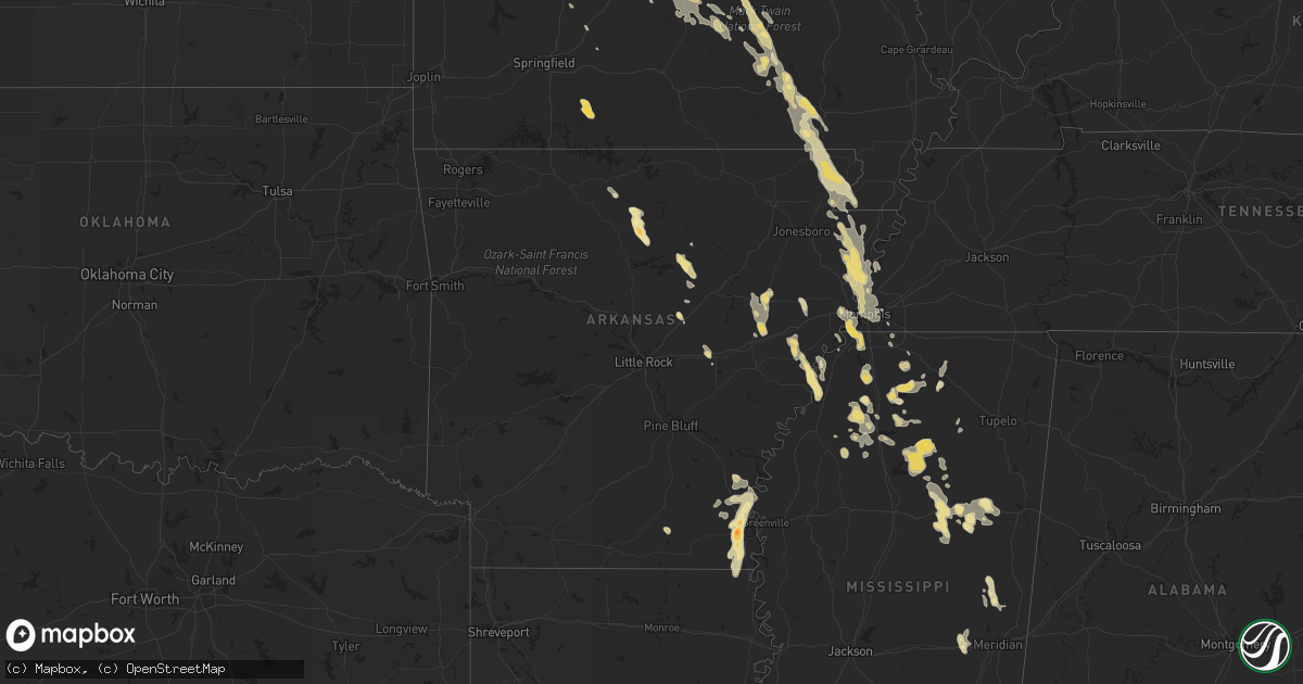
Hail Map in Tennessee on June 13, 2011
Get this storm
June 13 map
$229
one time, instant access
Download today. No call, no setup
Keep the $229
Bought the map and want the full workflow? Apply the entire $229 to a subscription within 7 days. None of it is wasted.
Every map, not just this one
This buys you this map. Subscription and you get every map we run, in the markets you choose from a few cities to whole states to nationwide. Plus real-time alerts the moment a storm fires.
Contact data
Name, contact info, occupancy, even credit band for addresses in the footprint. You go from where it hit to who to call.
Become the source they trust
Unlimited branding weather history reports on demand. You already have the documented answer ready for the property owner, and you are the one who showed up with it.
Property data and RoofTrace estimates
Pull up any address you have got, its value and the exact code rules for that jurisdiction, straight from One Click Code. Then RoofTrace estimates the squares, pitch, and roof value, priced the way you price.
Storm reports in Tennessee
Tennessee
| Date | Description |
|---|---|
| 06/13/20112:28 PM CDT | Second round of wind gusts near 75 mph with bookend vortex. Winds shifted from northwest to east. |
| 06/13/20112:22 PM CDT | Storm chaser reports 70 mph winds with hail to one inch along with large wall cloud just northwest of collierville. |
| 06/13/20112:11 PM CDT | Large tree blown down and completely blocking road at north parkway and montgomery. |
| 06/13/20112:05 PM CDT | Thunderstorm wind gust reported by contract weather observer at memphis intl airport. |
| 06/13/20111:55 PM CDT | Report of swirling winds and debris in hickory hill area going west of winchester and perkins with damage to roof of a bakery near lamar ave. |
| 06/13/20111:55 PM CDT | Large tree down in yard. |
| 06/13/20111:53 PM CDT | Thunderstorm wind gust reported by contract weather observer at memphis intl airport. |
| 06/13/20111:50 PM CDT | Prolonged northwest gusts to 75 mph with squall line. |
| 06/13/20111:00 PM CDT | Near richardson close to mississippi river. |
| 06/13/201112:05 PM CDT | Winds estimated at 60 mph with large tree limbs down at intersection of union and quico in millington. |
All States Impacted by Hail Map on June 13, 2011
Cities Impacted by Hail Map on June 13, 2011
- Tunica, MS
- Oslo, MN
- Manvel, ND
- Minto, ND
- Akron, CO
- Brush, CO
- Woodrow, CO
- Casey, IA
- Menlo, IA
- Diagonal, IA
- Shannon City, IA
- Kinderhook, IL
- Barry, IL
- Rockport, IL
- Pittsfield, IL
- New Canton, IL
- Silver Springs, FL
- Anthony, FL
- Fayette, MO
- New Franklin, MO
- Bunker, MO
- Jadwin, MO
- Salem, MO
- Long Lane, MO
- Blackwell, MO
- De Soto, MO
- Tutwiler, MS
- Sumter, SC
- Lodgepole, NE
- Martin, SD
- Alachua, FL
- High Springs, FL
- Lake City, FL
- Beebe, AR
- Nemo, SD
- Deadwood, SD
- Higginsville, MO
- Concordia, MO
- Corder, MO
- Lexington, MO
- Mayview, MO
- Pella, IA
- Sidney, NE
- Thayer, IA
- Ellston, IA
- Osceola, IA
- Grand River, IA
- Lenox, IA
- Murray, IA
- Afton, IA
- Perry, FL
- Anton, CO
- Van Meter, IA
- Winterset, IA
- Urbandale, IA
- Earlham, IA
- Dexter, IA
- West Des Moines, IA
- Clive, IA
- Adel, IA
- Windsor Heights, IA
- De Soto, IA
- Des Moines, IA
- Waukee, IA
- Burrton, KS
- Owanka, SD
- Wasta, SD
- Pulaski, IA
- Orrick, MO
- Sibley, MO
- Levasy, MO
- Buckner, MO
- Wellington, MO
- Napoleon, MO
- Harrison, NE
- Oak Grove, LA
- Marianna, AR
- Forrest City, AR
- Haynes, AR
- Rocky Mount, MO
- Lake Ozark, MO
- Sunrise Beach, MO
- Mora, MO
- Gravois Mills, MO
- Versailles, MO
- Lincoln, MO
- Kaiser, MO
- Osage Beach, MO
- Camdenton, MO
- Climax Springs, MO
- Linn Creek, MO
- Eldon, MO
- Edwards, MO
- Cole Camp, MO
- Stover, MO
- Eugene, MO
- Henley, MO
- Tuscumbia, MO
- Middletown, MO
- Macon, MO
- Callao, MO
- Ethel, MO
- New Cambria, MO
- Bevier, MO
- Hickory Ridge, AR
- McCrory, AR
- Wynne, AR
- Novinger, MO
- Letcher, SD
- White Lake, SD
- Mitchell, SD
- Platte, SD
- Plankinton, SD
- Mount Vernon, SD
- Stickney, SD
- Columbia, MO
- Boonville, MO
- New Bloomfield, MO
- Wooldridge, MO
- Prairie Home, MO
- Ashland, MO
- Jamestown, MO
- Fulton, MO
- Hartsburg, MO
- Genoa, CO
- Princeton, MO
- Lucerne, MO
- Newtown, MO
- Centerville, IA
- Moulton, IA
- Drakesville, IA
- Bloomfield, IA
- Melrose, IA
- Unionville, IA
- Moravia, IA
- Udell, IA
- Syracuse, MO
- Tipton, MO
- Palmyra, MO
- Sanborn, ND
- Pleasant Hill, IL
- Maxwell, IA
- Monroe, IA
- Otley, IA
- Concord, AR
- Drasco, AR
- Tumbling Shoals, AR
- Wilburn, AR
- Ida, AR
- Elgin, ND
- New Leipzig, ND
- Cantonment, FL
- Pensacola, FL
- Green Castle, MO
- Payson, IL
- Cedarbluff, MS
- Starkville, MS
- Collins, IA
- Cambridge, IA
- Rector, AR
- Marmaduke, AR
- Corning, AR
- Lafe, AR
- Hilliard, FL
- Cunningham, KS
- Meadville, MO
- Linneus, MO
- Slater, IA
- Bennett, CO
- Clark, SD
- Loose Creek, MO
- Linn, MO
- Bonnots Mill, MO
- Defiance, MO
- Lake Saint Louis, MO
- Wentzville, MO
- Waterloo, IL
- Bingham, NE
- Stapleton, NE
- Ellsworth, NE
- Mobile, AL
- Grand Bay, AL
- De Kalb, MS
- Timbo, AR
- Fox, AR
- Onia, AR
- Leslie, AR
- Shirley, AR
- Mountain View, AR
- Cuba, MO
- Owensville, MO
- Aurora, CO
- Halstead, KS
- Indianola, IA
- Ackworth, IA
- Paxton, NE
- Sutherland, NE
- Whitman, NE
- Milton, FL
- Enid, MS
- Crenshaw, MS
- Sardis, MS
- Sledge, MS
- Batesville, MS
- Marks, MS
- Pope, MS
- Courtland, MS
- Hazen, AR
- Knob Noster, MO
- Warrensburg, MO
- Lacona, IA
- Carson, ND
- Pangburn, AR
- Floral, AR
- Sedalia, MO
- Edgar Springs, MO
- Dixon, MO
- Green Ridge, MO
- Saint James, MO
- Duke, MO
- Vienna, MO
- Lenox, MO
- Barnett, MO
- Beulah, MO
- Brumley, MO
- Montreal, MO
- Jerome, MO
- Newburg, MO
- Crocker, MO
- Ulman, MO
- Russellville, MO
- Warsaw, MO
- Iberia, MO
- Saint Elizabeth, MO
- Licking, MO
- Windsor, MO
- Rolla, MO
- Olean, MO
- Roach, MO
- Brinktown, MO
- Meta, MO
- Ionia, MO
- Devils Elbow, MO
- Kingman, KS
- Cadet, MO
- Potosi, MO
- Bonne Terre, MO
- Richwoods, MO
- Drayton, ND
- Gilby, ND
- Purvis, MS
- New Zion, SC
- Salters, SC
- Lane, SC
- Baylis, IL
- Liberty, IL
- Perry, IL
- Chambersburg, IL
- Clayton, IL
- Plainville, IL
- New Salem, IL
- Griggsville, IL
- Sullivan, MO
- Bourbon, MO
- Folkston, GA
- Bussey, IA
- Hamilton, IA
- Portland, AR
- Lake Village, AR
- Jacksonville, FL
- Marsland, NE
- Crawford, NE
- Hemingford, NE
- Lindon, CO
- Valentine, NE
- Lugoff, SC
- Manning, SC
- Derby, IA
- Chariton, IA
- Memphis, TN
- Fort Morgan, CO
- Log Lane Village, CO
- Live Oak, FL
- McAlpin, FL
- Cherryville, MO
- Wesco, MO
- Centerville, MO
- Redford, MO
- Ellington, MO
- Cook Sta, MO
- Steelville, MO
- Boss, MO
- Coffeeville, MS
- Niangua, MO
- Conway, MO
- Bruce, MS
- Banner, MS
- Water Valley, MS
- Mount Sterling, IL
- Ottumwa, IA
- Blakesburg, IA
- Livonia, MO
- Carrabelle, FL
- New Raymer, CO
- Union, IA
- Marshalltown, IA
- Conrad, IA
- State Center, IA
- Saint Anthony, IA
- Liscomb, IA
- Albion, IA
- Clemons, IA
- Arriba, CO
- Montgomery City, MO
- Lambert, MS
- Paragould, AR
- Peetz, CO
- Crook, CO
- Greenfield, IA
- Fontanelle, IA
- Alma, MO
- Bland, MO
- Harrisburg, NE
- Parkersburg, IA
- Austinville, IA
- Ackley, IA
- Aplington, IA
- Woodlawn, IL
- Mount Vernon, IL
- Belle, MO
- Leasburg, MO
- Summerton, SC
- Pinewood, SC
- Granger, IA
- Huxley, IA
- Macksburg, IA
- Elkhart, IA
- Colo, IA
- Ankeny, IA
- Milo, IA
- Johnston, IA
- Beaman, IA
- Bouton, IA
- Stuart, IA
- Carlisle, IA
- Grimes, IA
- Orient, IA
- Woodward, IA
- Minburn, IA
- Nevada, IA
- Cumming, IA
- Norwalk, IA
- Kelley, IA
- Dallas Center, IA
- Pleasant Hill, IA
- Ames, IA
- Gladbrook, IA
- Martensdale, IA
- Prole, IA
- Bondurant, IA
- Madrid, IA
- Sheldahl, IA
- Mitchellville, IA
- Redfield, IA
- Alleman, IA
- Altoona, IA
- Polk City, IA
- Zearing, IA
- Mingo, IA
- Berwick, IA
- Dyess, AR
- Saint Thomas, MO
- Jefferson City, MO
- Westphalia, MO
- Humeston, IA
- Corydon, IA
- Rocheport, MO
- Cotton Plant, AR
- Wheatley, AR
- Hunter, AR
- Edwardsville, IL
- Dorsey, IL
- Bethalto, IL
- Moro, IL
- Hamel, IL
- Worden, IL
- Alton, IL
- Alhambra, IL
- Irvington, AL
- Theodore, AL
- Bowen, IL
- Martinsburg, MO
- Benton City, MO
- Auxvasse, MO
- Mexico, MO
- Luray, MO
- Como, MS
- Dermott, AR
- Seymour, IA
- Promise City, IA
- Hooper, NE
- Carpenter, SD
- Raymond, SD
- Clear Lake, IA
- Rockwell, IA
- Mason City, IA
- Oxford, MS
- Kirksville, MO
- Greentop, MO
- Steinhatchee, FL
- Timewell, IL
- Versailles, IL
- Custer, SD
- Potts Camp, MS
- Hermitage, AR
- Marceline, MO
- Templeton, IA
- Dedham, IA
- Lake Butler, FL
- Walls, MS
- Lake Cormorant, MS
- Williamstown, MO
- Bunceton, MO
- Clarksburg, MO
- California, MO
- Centertown, MO
- Panama City, FL
- Waterford, MS
- Holly Springs, MS
- Williston, FL
- Morriston, FL
- Saint Charles, MO
- Portage Des Sioux, MO
- Hill City, SD
- Rapid City, SD
- Oskaloosa, IA
- Knoxville, IA
- Harvey, IA
- Tracy, IA
- Cody, NE
- Merriman, NE
- Ashby, NE
- Maben, MS
- Mathiston, MS
- Laclede, MO
- Wheeling, MO
- Brookfield, MO
- Chula, MO
- Laredo, MO
- Wellsville, MO
- Laddonia, MO
- Rush Hill, MO
- Oshkosh, NE
- Lewellen, NE
- Gurley, NE
- Proctor, AR
- Crawfordsville, AR
- Eudora, AR
- Rohwer, AR
- Benoit, MS
- Arkansas City, AR
- Vardaman, MS
- Calhoun City, MS
- Derma, MS
- Big Creek, MS
- Arvilla, ND
- Panora, IA
- Helena, AR
- West Helena, AR
- Dundee, MS
- Hillsboro, MO
- Wedgefield, SC
- Bunnell, FL
- Palm Coast, FL
- Bucklin, MO
- Lawtey, FL
- Eupora, MS
- Ackerman, MS
- Weir, MS
- Burlington, CO
- Mendon, IL
- Canton, MO
- Warsaw, IL
- Ursa, IL
- Kimball, NE
- Lisco, NE
- Newton, MS
- Decatur, MS
- Hickory, MS
- Ava, MO
- Guthrie Center, IA
- Byhalia, MS
- Deep River, IA
- Green Cove Springs, FL
- Palatka, FL
- Andrews, SC
- Lake Park, GA
- Miami, MO
- Fairdealing, MO
- Hornersville, MO
- Arbyrd, MO
- Poplar Bluff, MO
- Knobel, AR
- Grandin, MO
- Piggott, AR
- Harviell, MO
- Naylor, MO
- Neelyville, MO
- Doniphan, MO
- Oxly, MO
- Ellsinore, MO
- Senath, MO
- Artesian, SD
- Dix, NE
- Olive Branch, MS
- Coldwater, MS
- Senatobia, MS
- Bradleyville, MO
- Van Buren, MO
- Foristell, MO
- Memphis, MO
- Sturgis, MS
- Nashville, GA
- Alapaha, GA
- Mott, ND
- Preston, MS
- Audubon, IA
- O'Brien, FL
- West Point, IL
- Sutter, IL
- Arthur, NE
- Shubuta, MS
- Heidelberg, MS
- Laurel, MS
- Hermosa, SD
- Chadwick, MO
- Oldfield, MO
- Cascilla, MS
- Charleston, MS
- Tillatoba, MS
- Doland, SD
- Byers, CO
- Golden Eagle, IL
- Winfield, MO
- Old Monroe, MO
- O'Fallon, MO
- Brussels, IL
- Wilson, AR
- Frenchmans Bayou, AR
- Joiner, AR
- San Mateo, FL
- Alexandria, MO
- Gore Springs, MS
- Littleton, CO
- Englewood, CO
- Ethan, SD
- Alexandria, SD
- Yellville, AR
- Lorimor, IA
- Big Springs, NE
- Crawfordville, FL
- Malta Bend, MO
- Saint George, GA
- Lake Worth, FL
- West Palm Beach, FL
- Ashley, IL
- Sigourney, IA
- Grafton, ND
- Creston, IA
- Padroni, CO
- Potter, NE
- What Cheer, IA
- Gibson, IA
- Keswick, IA
- New Sharon, IA
- Barnes City, IA
- Onawa, IA
- McGehee, AR
- Tillar, AR
- La Belle, MO
- Monticello, MO
- Lewistown, MO
- Bush, LA
- Melcher Dallas, IA
- Beacon, IA
- Lovilia, IA
- Swan, IA
- South English, IA
- Leighton, IA
- North English, IA
- Webster, IA
- Albia, IA
- Pleasantville, IA
- Eddyville, IA
- Columbia, IA
- Lancaster, MO
- Glenwood, MO
- Scribner, NE
- Douds, IA
- Milton, IA
- Eldora, IA
- Whitten, IA
- Arbela, MO
- Kahoka, MO
- Lake City, AR
- West Point, NE
- Hyannis, NE
- Vale, SD
- Oakland, NE
- Beemer, NE
- Elsah, IL
- Grafton, IL
- Hope, ND
- Tingley, IA
- Fort White, FL
- Wellborn, FL
- Branford, FL
- Troy, MO
- Moscow Mills, MO
- Wright City, MO
- Millington, TN
- Salisbury, MO
- Alcolu, SC
- Eastover, SC
- Hebron, ND
- Alliance, NE
- Atlantic, IA
- Anita, IA
- Florissant, MO
- Parkdale, AR
- Holt, FL
- Horseshoe Beach, FL
- Whiteman Air Force Base, MO
- Gordon, NE
- Batesland, SD
- Gulf Breeze, FL
- Sweet Springs, MO
- Houstonia, MO
- Irwin, IA
- Marshall, MO
- Walthall, MS
- McCool, MS
- Bellefontaine, MS
- Watkins, CO
- Denver, CO
- Commerce City, CO
- Greenville, FL
- Lamont, FL
- Black Oak, AR
- Dell, AR
- Manila, AR
- Keiser, AR
- Gilmore, AR
- Etowah, AR
- Marion, AR
- Bassett, AR
- Osceola, AR
- Turrell, AR
- Caraway, AR
- Drummonds, TN
- Monette, AR
- Leachville, AR
- West Memphis, AR
- Lepanto, AR
- Queen City, MO
- Powersville, MO
- Santa Fe, MO
- Brinkley, AR
- Bell, FL
- Trenton, FL
- Chiefland, FL
- Rembert, SC
- Hernando, MS
- Horn Lake, MS
- Nesbit, MS
- Gadsden, SC
- Archer, FL
- Strasburg, CO
- Mekinock, ND
- Festus, MO
- Bloomsdale, MO
- Pender, NE
- Bancroft, NE
- Scenic, SD
- Mondamin, IA
- Little Sioux, IA
- Tekamah, NE
- Cardwell, MO
- Linden, IA
- Gorin, MO
- Loraine, IL
- Wyaconda, MO
- Floris, IA
- Mount Sterling, IA
- Revere, MO
- Wayland, MO
- Keokuk, IA
- Rutledge, MO
- Basco, IL
- La Grange, MO
- Saint Patrick, MO
- Cantril, IA
- Big Flat, AR
- Pontotoc, MS
- Reddick, FL
- Jupiter, FL
- Downing, MO
- Hubbard, IA
- New Providence, IA
- Camden, MO
- Blackburn, MO
- Henrietta, MO
- Camp Point, IL
- Quincy, IL
- Fowler, IL
- Sully, IA
- Dalton, NE
- Montezuma, IA
- Odessa, MO
- Ute, IA
- Cottonwood Falls, KS
- Elmdale, KS
- Ashland, MS
- Hickory Flat, MS
- Craig, NE
- Brickeys, AR
- Flagler Beach, FL
- Hopkins, SC
- Breese, IL
- Carlyle, IL
- Oakland, MS
- Modale, IA
- Ocala, FL
- Citra, FL
- Colfax, IA
- Virginia, IL
- Beardstown, IL
- Wisner, NE
- Glasgow, MO
- Youngstown, FL
- Russell, IA
- Success, AR
- Winona, MO
- Williamsville, MO
- Richmond, MO
- Hardin, MO
- Upton, WY
- Bushnell, NE
- Centralia, MO
- Williamsburg, IA
- Hemingway, SC
- Nesmith, SC
- Georgetown, SC
- Libertyville, IA
- Fairfield, IA
- Waverly, MO
- Norborne, MO
- Carrollton, MO
- Valdosta, GA
- Emporia, KS
- Little Rock, MS
- Coon Rapids, IA
- Stanton, NE
- Pilger, NE
- Kyle, SD
- Louisiana, MO
- Jennings, FL
- Peru, IA
- Taylor, MS
- Inman, KS
- Buhler, KS
- Harriet, AR
- Marshall, AR
- Edgemont, AR
- Purdum, NE
- Yale, IA
- Slater, MO
- Herman, NE
- McCallsburg, IA
- La Monte, MO
- Vandalia, MO
- Iliff, CO
- Kampsville, IL
- Nebo, IL
- Jerseyville, IL
- Tebbetts, MO
- Saint Mary, MO
- Easley, SC
- Hay Springs, NE
- Tryon, NE
- Brashear, MO
- Baring, MO
- Aviston, IL
- Bunker Hill, IL
- Pocahontas, IL
- Marine, IL
- Staunton, IL
- Beckemeyer, IL
- Piasa, IL
- Godfrey, IL
- Highland, IL
- Brighton, IL
- New Douglas, IL
- Umatilla, FL
- Spickard, MO
- Trenton, MO
- Galt, MO
- Mercer, MO
- Fort Leonard Wood, MO
- Waynesville, MO
- Laquey, MO
- Frankford, MO
- Coahoma, MS
- Mayo, FL
- Cumberland, IA
- Massena, IA
- Keystone Heights, FL
- Melrose, FL
- Fleming, CO
- Saint Augustine, FL
- Woonsocket, SD
- Germantown, TN
- Isabel, KS
- Burwell, NE
- Soldier, IA
- Unionville, MO
- Searcy, AR
- Letona, AR
- Wall, SD
- Searsboro, IA
- Kane, IL
- Pilot Grove, MO
- Richview, IL
- Irvington, IL
- Dix, IL
- Centralia, IL
- Old Town, FL
- Broadwater, NE
- Woodbine, IA
- Logan, IA
- Valmeyer, IL
- Hawthorne, FL
- Curryville, MO
- Leesburg, FL
- Locust Grove, AR
- Robinsonville, MS
- Wewahitchka, FL
- Augusta, IL
- Huntsville, IL
- Mystic, IA
- Bluffs, IL
- Ewing, MO
- Taylor, MO
- Coatsburg, IL
- Edina, MO
- Hurdland, MO
- Maywood, MO
- Farmington, IA
- Paloma, IL
- Golden, IL
- Chillicothe, IA
- Hull, IL
- Plano, IA
- Bonaparte, IA
- Knox City, MO
- Keosauqua, IA
- Fort McCoy, FL
- Jefferson, IA
- Luverne, ND
- Woodburn, IA
- Weldon, IA
- Smithton, MO
- Hughes, AR
- Allerton, IA
- Coatsville, MO
- Chapin, IL
- Arlington, KS
- Hartford, IA
- Franklin, MO
- Marshfield, MO
- Abbeville, MS
- Centerview, MO
- Perryville, MO
- Navarre, FL
- Bagdad, FL
- Eglin Afb, FL
- Holts Summit, MO
- Flippin, AR
- Stoneham, CO
- Koeltztown, MO
- Argyle, MO
- Snyder, CO
- Yuma, CO
- Lyons, NE
- Newell, SD
- Chappell, NE
- Pine Ridge, SD
- Pollock, MO
- Bridgewater, IA
- Exline, IA
- Cincinnati, IA
- Mullen, NE
- Callahan, FL
- Reasnor, IA
- Vance, MS
- West Alton, MO
- Dow, IL
- Decatur, NE
- New Virginia, IA
- Duck Hill, MS
- Pheba, MS
- Hoyleton, IL
- Black, MO
- Prairie City, IA
- Runnells, IA
- Daleville, MS
- Loxahatchee, FL
- Palm Beach Gardens, FL
- Fulton, SD


