Hail Map in Mississippi on June 13, 2011
Get this storm
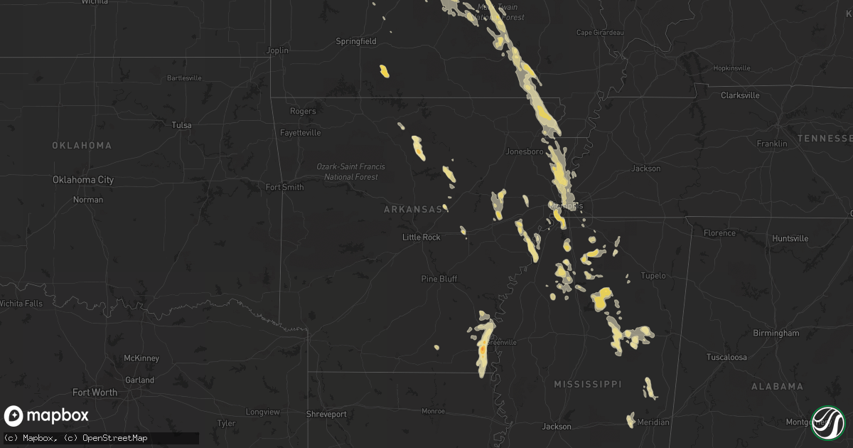
June 13 map
$229
one time, instant access
Download today. No call, no setup
Keep the $229
Bought the map and want the full workflow? Apply the entire $229 to a subscription within 7 days. None of it is wasted.
Every map, not just this one
This buys you this map. Subscription and you get every map we run, in the markets you choose from a few cities to whole states to nationwide. Plus real-time alerts the moment a storm fires.
Contact data
Name, contact info, occupancy, even credit band for addresses in the footprint. You go from where it hit to who to call.
Become the source they trust
Unlimited branding weather history reports on demand. You already have the documented answer ready for the property owner, and you are the one who showed up with it.
Property data and RoofTrace estimates
Pull up any address you have got, its value and the exact code rules for that jurisdiction, straight from One Click Code. Then RoofTrace estimates the squares, pitch, and roof value, priced the way you price.
Storm reports in Mississippi
Mississippi
| Date | Description |
|---|---|
| 06/13/20116:58 PM CDT | Trees down around braxton...pinola and mendenhall. |
| 06/13/20116:50 PM CDT | Several trees and some power lines downed across clarke county...power out in much of the city of quitman |
| 06/13/20116:50 PM CDT | Trees downed across the road along hwy 531 near hwy 18 |
| 06/13/20116:45 PM CDT | Several trees down in western smith county including in raleigh and in polkville. |
| 06/13/20116:45 PM CDT | Power lines downed between bay springs and louin |
| 06/13/20116:45 PM CDT | Tree downed on power lines. |
| 06/13/20116:35 PM CDT | Powerlines down across i-55. |
| 06/13/20116:25 PM CDT | A local report indicates 60 MPH wind near 4 W BRANDON |
| 06/13/20116:20 PM CDT | At trustmark park in pearl |
| 06/13/20116:20 PM CDT | Tree downed partially blocking i-20 westbound near mile marker 60. |
| 06/13/20116:20 PM CDT | Very large tree through the roof of a house |
| 06/13/20116:17 PM CDT | Power outages around bailey |
| 06/13/20116:15 PM CDT | Several trees down around morton |
| 06/13/20116:05 PM CDT | Power poles were downed along spillway rd...causing a grass fire. |
| 06/13/20116:03 PM CDT | Tree down along meadow ridge drive and timber lane road. |
| 06/13/20115:50 PM CDT | Trees down...trees across roads and a tree on a house in the ludlow and branch communities. |
| 06/13/20115:35 PM CDT | Power line downed along road 2826 northeast of philadelphia |
| 06/13/20115:30 PM CDT | Numerous trees down in yazoo city |
| 06/13/20115:15 PM CDT | Trees and power lines downed |
| 06/13/20115:10 PM CDT | Several trees down west of louisville |
| 06/13/20115:10 PM CDT | Trees downed along ms highway 39 |
| 06/13/20114:50 PM CDT | Several trees and power lines down in holmes county...including along highway 12 and highway 17. |
| 06/13/20114:50 PM CDT | Roof came off a grocery store and water has entered the building. |
| 06/13/20114:45 PM CDT | Power lines downed |
| 06/13/20114:40 PM CDT | Trees down across highway 35 |
| 06/13/20114:35 PM CDT | A couple trees downed...and power lines downed |
| 06/13/20114:35 PM CDT | Power line downed along road 2826 northeast of philadelphia |
| 06/13/20114:30 PM CDT | Several trees and power lines downed countywide...canopies blown off of businesses in the city of eupora |
| 06/13/20114:30 PM CDT | Trees down across highway 17 |
| 06/13/20114:30 PM CDT | Several trees down...two trees fell on houses |
| 06/13/20114:15 PM CDT | Several trees down...some blocking roadways including highway 404. |
| 06/13/20114:10 PM CDT | A large tree was downed across duncan rd near holcomb. |
| 06/13/20114:10 PM CDT | Numerous trees downed in the grenada area |
| 06/13/20114:00 PM CDT | Multiple trees downed |
| 06/13/20113:50 PM CDT | Trees down across the road and powerlines. Two homes also sustained some roof damage. |
| 06/13/20113:50 PM CDT | Trees down across the road and powerlines. |
| 06/13/20113:45 PM CDT | 60 mph winds 6 miles east of parchman on hwy 32. |
| 06/13/20113:40 PM CDT | *** 1 inj *** trees and power lines down in the northeast part of tallahatchie county. |
| 06/13/20112:45 PM CDT | Tractor trailer overturned on us 278 and ms hwy 6 just east of clarksdale. |
| 06/13/20112:45 PM CDT | Tractor trailer overturned on hwy 49 toward helena bridge |
| 06/13/20112:30 PM CDT | Trees down throughout tate county. |
| 06/13/20112:25 PM CDT | *** 1 inj *** wind gust estimated at 95 mph occurred between 225 pm and 230 pm at the olive branch airport. Damage to hangars resulted and planes were overturned. An ai |
| 06/13/20112:11 PM CDT | Large tree blow down and completely blocking road at north parkway and montgomery. |
| 06/13/20112:05 PM CDT | At memphis intl fcwos. |
| 06/13/20111:58 PM CDT | Small tree limbs down. |
| 06/13/20111:58 PM CDT | Olive branch airport. Wind damage to hangers and planes overturned. |
| 06/13/20111:57 PM CDT | Quarter to ping pong size hail |
| 06/13/20111:55 PM CDT | Report of swirling winds and debris in hickory hill area going west near winchester and perkins with damage to roof of bakery. |
| 06/13/20111:53 PM CDT | Thunderstorm wind gust from fcwos observer at memphis intl airport. |
| 06/12/201110:00 PM CDT | Numerous large tree limbs down...patio furniture blown around...garbage cans knocked over...and a vhf antenna blowned down. |
| 06/12/20118:00 PM CDT | Tree reported down on hinton drive |
| 06/12/20117:40 PM CDT | Tree down on airport road |
| 06/12/20117:35 PM CDT | Trees were downed in silver creek |
| 06/12/20117:31 PM CDT | Trees and powerlines reported down on shady oak church road east of collins. |
| 06/12/20117:25 PM CDT | Tree down on jones ford in the northwest part of the county |
| 06/12/20117:03 PM CDT | Power lines down in sandersville. |
| 06/12/20117:03 PM CDT | Roof partially removed from a house. |
| 06/12/20117:00 PM CDT | Canopy blown off of a chicken plant loading dock. |
| 06/12/20117:00 PM CDT | Trees down in town |
| 06/12/20117:00 PM CDT | A local report indicates 1.00 inch wind near SANDERSVILLE |
All States Impacted by Hail Map on June 13, 2011
Cities Impacted by Hail Map on June 13, 2011
- Tunica, MS
- Oslo, MN
- Manvel, ND
- Minto, ND
- Akron, CO
- Brush, CO
- Woodrow, CO
- Casey, IA
- Menlo, IA
- Diagonal, IA
- Shannon City, IA
- Kinderhook, IL
- Barry, IL
- Rockport, IL
- Pittsfield, IL
- New Canton, IL
- Silver Springs, FL
- Anthony, FL
- Fayette, MO
- New Franklin, MO
- Bunker, MO
- Jadwin, MO
- Salem, MO
- Long Lane, MO
- Blackwell, MO
- De Soto, MO
- Tutwiler, MS
- Sumter, SC
- Lodgepole, NE
- Martin, SD
- Alachua, FL
- High Springs, FL
- Lake City, FL
- Beebe, AR
- Nemo, SD
- Deadwood, SD
- Higginsville, MO
- Concordia, MO
- Corder, MO
- Lexington, MO
- Mayview, MO
- Pella, IA
- Sidney, NE
- Thayer, IA
- Ellston, IA
- Osceola, IA
- Grand River, IA
- Lenox, IA
- Murray, IA
- Afton, IA
- Perry, FL
- Anton, CO
- Van Meter, IA
- Winterset, IA
- Urbandale, IA
- Earlham, IA
- Dexter, IA
- West Des Moines, IA
- Clive, IA
- Adel, IA
- Windsor Heights, IA
- De Soto, IA
- Des Moines, IA
- Waukee, IA
- Burrton, KS
- Owanka, SD
- Wasta, SD
- Pulaski, IA
- Orrick, MO
- Sibley, MO
- Levasy, MO
- Buckner, MO
- Wellington, MO
- Napoleon, MO
- Harrison, NE
- Oak Grove, LA
- Marianna, AR
- Forrest City, AR
- Haynes, AR
- Rocky Mount, MO
- Lake Ozark, MO
- Sunrise Beach, MO
- Mora, MO
- Gravois Mills, MO
- Versailles, MO
- Lincoln, MO
- Kaiser, MO
- Osage Beach, MO
- Camdenton, MO
- Climax Springs, MO
- Linn Creek, MO
- Eldon, MO
- Edwards, MO
- Cole Camp, MO
- Stover, MO
- Eugene, MO
- Henley, MO
- Tuscumbia, MO
- Middletown, MO
- Macon, MO
- Callao, MO
- Ethel, MO
- New Cambria, MO
- Bevier, MO
- Hickory Ridge, AR
- McCrory, AR
- Wynne, AR
- Novinger, MO
- Letcher, SD
- White Lake, SD
- Mitchell, SD
- Platte, SD
- Plankinton, SD
- Mount Vernon, SD
- Stickney, SD
- Columbia, MO
- Boonville, MO
- New Bloomfield, MO
- Wooldridge, MO
- Prairie Home, MO
- Ashland, MO
- Jamestown, MO
- Fulton, MO
- Hartsburg, MO
- Genoa, CO
- Princeton, MO
- Lucerne, MO
- Newtown, MO
- Centerville, IA
- Moulton, IA
- Drakesville, IA
- Bloomfield, IA
- Melrose, IA
- Unionville, IA
- Moravia, IA
- Udell, IA
- Syracuse, MO
- Tipton, MO
- Palmyra, MO
- Sanborn, ND
- Pleasant Hill, IL
- Maxwell, IA
- Monroe, IA
- Otley, IA
- Concord, AR
- Drasco, AR
- Tumbling Shoals, AR
- Wilburn, AR
- Ida, AR
- Elgin, ND
- New Leipzig, ND
- Cantonment, FL
- Pensacola, FL
- Green Castle, MO
- Payson, IL
- Cedarbluff, MS
- Starkville, MS
- Collins, IA
- Cambridge, IA
- Rector, AR
- Marmaduke, AR
- Corning, AR
- Lafe, AR
- Hilliard, FL
- Cunningham, KS
- Meadville, MO
- Linneus, MO
- Slater, IA
- Bennett, CO
- Clark, SD
- Loose Creek, MO
- Linn, MO
- Bonnots Mill, MO
- Defiance, MO
- Lake Saint Louis, MO
- Wentzville, MO
- Waterloo, IL
- Bingham, NE
- Stapleton, NE
- Ellsworth, NE
- Mobile, AL
- Grand Bay, AL
- De Kalb, MS
- Timbo, AR
- Fox, AR
- Onia, AR
- Leslie, AR
- Shirley, AR
- Mountain View, AR
- Cuba, MO
- Owensville, MO
- Aurora, CO
- Halstead, KS
- Indianola, IA
- Ackworth, IA
- Paxton, NE
- Sutherland, NE
- Whitman, NE
- Milton, FL
- Enid, MS
- Crenshaw, MS
- Sardis, MS
- Sledge, MS
- Batesville, MS
- Marks, MS
- Pope, MS
- Courtland, MS
- Hazen, AR
- Knob Noster, MO
- Warrensburg, MO
- Lacona, IA
- Carson, ND
- Pangburn, AR
- Floral, AR
- Sedalia, MO
- Edgar Springs, MO
- Dixon, MO
- Green Ridge, MO
- Saint James, MO
- Duke, MO
- Vienna, MO
- Lenox, MO
- Barnett, MO
- Beulah, MO
- Brumley, MO
- Montreal, MO
- Jerome, MO
- Newburg, MO
- Crocker, MO
- Ulman, MO
- Russellville, MO
- Warsaw, MO
- Iberia, MO
- Saint Elizabeth, MO
- Licking, MO
- Windsor, MO
- Rolla, MO
- Olean, MO
- Roach, MO
- Brinktown, MO
- Meta, MO
- Ionia, MO
- Devils Elbow, MO
- Kingman, KS
- Cadet, MO
- Potosi, MO
- Bonne Terre, MO
- Richwoods, MO
- Drayton, ND
- Gilby, ND
- Purvis, MS
- New Zion, SC
- Salters, SC
- Lane, SC
- Baylis, IL
- Liberty, IL
- Perry, IL
- Chambersburg, IL
- Clayton, IL
- Plainville, IL
- New Salem, IL
- Griggsville, IL
- Sullivan, MO
- Bourbon, MO
- Folkston, GA
- Bussey, IA
- Hamilton, IA
- Portland, AR
- Lake Village, AR
- Jacksonville, FL
- Marsland, NE
- Crawford, NE
- Hemingford, NE
- Lindon, CO
- Valentine, NE
- Lugoff, SC
- Manning, SC
- Derby, IA
- Chariton, IA
- Memphis, TN
- Fort Morgan, CO
- Log Lane Village, CO
- Live Oak, FL
- McAlpin, FL
- Cherryville, MO
- Wesco, MO
- Centerville, MO
- Redford, MO
- Ellington, MO
- Cook Sta, MO
- Steelville, MO
- Boss, MO
- Coffeeville, MS
- Niangua, MO
- Conway, MO
- Bruce, MS
- Banner, MS
- Water Valley, MS
- Mount Sterling, IL
- Ottumwa, IA
- Blakesburg, IA
- Livonia, MO
- Carrabelle, FL
- New Raymer, CO
- Union, IA
- Marshalltown, IA
- Conrad, IA
- State Center, IA
- Saint Anthony, IA
- Liscomb, IA
- Albion, IA
- Clemons, IA
- Arriba, CO
- Montgomery City, MO
- Lambert, MS
- Paragould, AR
- Peetz, CO
- Crook, CO
- Greenfield, IA
- Fontanelle, IA
- Alma, MO
- Bland, MO
- Harrisburg, NE
- Parkersburg, IA
- Austinville, IA
- Ackley, IA
- Aplington, IA
- Woodlawn, IL
- Mount Vernon, IL
- Belle, MO
- Leasburg, MO
- Summerton, SC
- Pinewood, SC
- Granger, IA
- Huxley, IA
- Macksburg, IA
- Elkhart, IA
- Colo, IA
- Ankeny, IA
- Milo, IA
- Johnston, IA
- Beaman, IA
- Bouton, IA
- Stuart, IA
- Carlisle, IA
- Grimes, IA
- Orient, IA
- Woodward, IA
- Minburn, IA
- Nevada, IA
- Cumming, IA
- Norwalk, IA
- Kelley, IA
- Dallas Center, IA
- Pleasant Hill, IA
- Ames, IA
- Gladbrook, IA
- Martensdale, IA
- Prole, IA
- Bondurant, IA
- Madrid, IA
- Sheldahl, IA
- Mitchellville, IA
- Redfield, IA
- Alleman, IA
- Altoona, IA
- Polk City, IA
- Zearing, IA
- Mingo, IA
- Berwick, IA
- Dyess, AR
- Saint Thomas, MO
- Jefferson City, MO
- Westphalia, MO
- Humeston, IA
- Corydon, IA
- Rocheport, MO
- Cotton Plant, AR
- Wheatley, AR
- Hunter, AR
- Edwardsville, IL
- Dorsey, IL
- Bethalto, IL
- Moro, IL
- Hamel, IL
- Worden, IL
- Alton, IL
- Alhambra, IL
- Irvington, AL
- Theodore, AL
- Bowen, IL
- Martinsburg, MO
- Benton City, MO
- Auxvasse, MO
- Mexico, MO
- Luray, MO
- Como, MS
- Dermott, AR
- Seymour, IA
- Promise City, IA
- Hooper, NE
- Carpenter, SD
- Raymond, SD
- Clear Lake, IA
- Rockwell, IA
- Mason City, IA
- Oxford, MS
- Kirksville, MO
- Greentop, MO
- Steinhatchee, FL
- Timewell, IL
- Versailles, IL
- Custer, SD
- Potts Camp, MS
- Hermitage, AR
- Marceline, MO
- Templeton, IA
- Dedham, IA
- Lake Butler, FL
- Walls, MS
- Lake Cormorant, MS
- Williamstown, MO
- Bunceton, MO
- Clarksburg, MO
- California, MO
- Centertown, MO
- Panama City, FL
- Waterford, MS
- Holly Springs, MS
- Williston, FL
- Morriston, FL
- Saint Charles, MO
- Portage Des Sioux, MO
- Hill City, SD
- Rapid City, SD
- Oskaloosa, IA
- Knoxville, IA
- Harvey, IA
- Tracy, IA
- Cody, NE
- Merriman, NE
- Ashby, NE
- Maben, MS
- Mathiston, MS
- Laclede, MO
- Wheeling, MO
- Brookfield, MO
- Chula, MO
- Laredo, MO
- Wellsville, MO
- Laddonia, MO
- Rush Hill, MO
- Oshkosh, NE
- Lewellen, NE
- Gurley, NE
- Proctor, AR
- Crawfordsville, AR
- Eudora, AR
- Rohwer, AR
- Benoit, MS
- Arkansas City, AR
- Vardaman, MS
- Calhoun City, MS
- Derma, MS
- Big Creek, MS
- Arvilla, ND
- Panora, IA
- Helena, AR
- West Helena, AR
- Dundee, MS
- Hillsboro, MO
- Wedgefield, SC
- Bunnell, FL
- Palm Coast, FL
- Bucklin, MO
- Lawtey, FL
- Eupora, MS
- Ackerman, MS
- Weir, MS
- Burlington, CO
- Mendon, IL
- Canton, MO
- Warsaw, IL
- Ursa, IL
- Kimball, NE
- Lisco, NE
- Newton, MS
- Decatur, MS
- Hickory, MS
- Ava, MO
- Guthrie Center, IA
- Byhalia, MS
- Deep River, IA
- Green Cove Springs, FL
- Palatka, FL
- Andrews, SC
- Lake Park, GA
- Miami, MO
- Fairdealing, MO
- Hornersville, MO
- Arbyrd, MO
- Poplar Bluff, MO
- Knobel, AR
- Grandin, MO
- Piggott, AR
- Harviell, MO
- Naylor, MO
- Neelyville, MO
- Doniphan, MO
- Oxly, MO
- Ellsinore, MO
- Senath, MO
- Artesian, SD
- Dix, NE
- Olive Branch, MS
- Coldwater, MS
- Senatobia, MS
- Bradleyville, MO
- Van Buren, MO
- Foristell, MO
- Memphis, MO
- Sturgis, MS
- Nashville, GA
- Alapaha, GA
- Mott, ND
- Preston, MS
- Audubon, IA
- O'Brien, FL
- West Point, IL
- Sutter, IL
- Arthur, NE
- Shubuta, MS
- Heidelberg, MS
- Laurel, MS
- Hermosa, SD
- Chadwick, MO
- Oldfield, MO
- Cascilla, MS
- Charleston, MS
- Tillatoba, MS
- Doland, SD
- Byers, CO
- Golden Eagle, IL
- Winfield, MO
- Old Monroe, MO
- O'Fallon, MO
- Brussels, IL
- Wilson, AR
- Frenchmans Bayou, AR
- Joiner, AR
- San Mateo, FL
- Alexandria, MO
- Gore Springs, MS
- Littleton, CO
- Englewood, CO
- Ethan, SD
- Alexandria, SD
- Yellville, AR
- Lorimor, IA
- Big Springs, NE
- Crawfordville, FL
- Malta Bend, MO
- Saint George, GA
- Lake Worth, FL
- West Palm Beach, FL
- Ashley, IL
- Sigourney, IA
- Grafton, ND
- Creston, IA
- Padroni, CO
- Potter, NE
- What Cheer, IA
- Gibson, IA
- Keswick, IA
- New Sharon, IA
- Barnes City, IA
- Onawa, IA
- McGehee, AR
- Tillar, AR
- La Belle, MO
- Monticello, MO
- Lewistown, MO
- Bush, LA
- Melcher Dallas, IA
- Beacon, IA
- Lovilia, IA
- Swan, IA
- South English, IA
- Leighton, IA
- North English, IA
- Webster, IA
- Albia, IA
- Pleasantville, IA
- Eddyville, IA
- Columbia, IA
- Lancaster, MO
- Glenwood, MO
- Scribner, NE
- Douds, IA
- Milton, IA
- Eldora, IA
- Whitten, IA
- Arbela, MO
- Kahoka, MO
- Lake City, AR
- West Point, NE
- Hyannis, NE
- Vale, SD
- Oakland, NE
- Beemer, NE
- Elsah, IL
- Grafton, IL
- Hope, ND
- Tingley, IA
- Fort White, FL
- Wellborn, FL
- Branford, FL
- Troy, MO
- Moscow Mills, MO
- Wright City, MO
- Millington, TN
- Salisbury, MO
- Alcolu, SC
- Eastover, SC
- Hebron, ND
- Alliance, NE
- Atlantic, IA
- Anita, IA
- Florissant, MO
- Parkdale, AR
- Holt, FL
- Horseshoe Beach, FL
- Whiteman Air Force Base, MO
- Gordon, NE
- Batesland, SD
- Gulf Breeze, FL
- Sweet Springs, MO
- Houstonia, MO
- Irwin, IA
- Marshall, MO
- Walthall, MS
- McCool, MS
- Bellefontaine, MS
- Watkins, CO
- Denver, CO
- Commerce City, CO
- Greenville, FL
- Lamont, FL
- Black Oak, AR
- Dell, AR
- Manila, AR
- Keiser, AR
- Gilmore, AR
- Etowah, AR
- Marion, AR
- Bassett, AR
- Osceola, AR
- Turrell, AR
- Caraway, AR
- Drummonds, TN
- Monette, AR
- Leachville, AR
- West Memphis, AR
- Lepanto, AR
- Queen City, MO
- Powersville, MO
- Santa Fe, MO
- Brinkley, AR
- Bell, FL
- Trenton, FL
- Chiefland, FL
- Rembert, SC
- Hernando, MS
- Horn Lake, MS
- Nesbit, MS
- Gadsden, SC
- Archer, FL
- Strasburg, CO
- Mekinock, ND
- Festus, MO
- Bloomsdale, MO
- Pender, NE
- Bancroft, NE
- Scenic, SD
- Mondamin, IA
- Little Sioux, IA
- Tekamah, NE
- Cardwell, MO
- Linden, IA
- Gorin, MO
- Loraine, IL
- Wyaconda, MO
- Floris, IA
- Mount Sterling, IA
- Revere, MO
- Wayland, MO
- Keokuk, IA
- Rutledge, MO
- Basco, IL
- La Grange, MO
- Saint Patrick, MO
- Cantril, IA
- Big Flat, AR
- Pontotoc, MS
- Reddick, FL
- Jupiter, FL
- Downing, MO
- Hubbard, IA
- New Providence, IA
- Camden, MO
- Blackburn, MO
- Henrietta, MO
- Camp Point, IL
- Quincy, IL
- Fowler, IL
- Sully, IA
- Dalton, NE
- Montezuma, IA
- Odessa, MO
- Ute, IA
- Cottonwood Falls, KS
- Elmdale, KS
- Ashland, MS
- Hickory Flat, MS
- Craig, NE
- Brickeys, AR
- Flagler Beach, FL
- Hopkins, SC
- Breese, IL
- Carlyle, IL
- Oakland, MS
- Modale, IA
- Ocala, FL
- Citra, FL
- Colfax, IA
- Virginia, IL
- Beardstown, IL
- Wisner, NE
- Glasgow, MO
- Youngstown, FL
- Russell, IA
- Success, AR
- Winona, MO
- Williamsville, MO
- Richmond, MO
- Hardin, MO
- Upton, WY
- Bushnell, NE
- Centralia, MO
- Williamsburg, IA
- Hemingway, SC
- Nesmith, SC
- Georgetown, SC
- Libertyville, IA
- Fairfield, IA
- Waverly, MO
- Norborne, MO
- Carrollton, MO
- Valdosta, GA
- Emporia, KS
- Little Rock, MS
- Coon Rapids, IA
- Stanton, NE
- Pilger, NE
- Kyle, SD
- Louisiana, MO
- Jennings, FL
- Peru, IA
- Taylor, MS
- Inman, KS
- Buhler, KS
- Harriet, AR
- Marshall, AR
- Edgemont, AR
- Purdum, NE
- Yale, IA
- Slater, MO
- Herman, NE
- McCallsburg, IA
- La Monte, MO
- Vandalia, MO
- Iliff, CO
- Kampsville, IL
- Nebo, IL
- Jerseyville, IL
- Tebbetts, MO
- Saint Mary, MO
- Easley, SC
- Hay Springs, NE
- Tryon, NE
- Brashear, MO
- Baring, MO
- Aviston, IL
- Bunker Hill, IL
- Pocahontas, IL
- Marine, IL
- Staunton, IL
- Beckemeyer, IL
- Piasa, IL
- Godfrey, IL
- Highland, IL
- Brighton, IL
- New Douglas, IL
- Umatilla, FL
- Spickard, MO
- Trenton, MO
- Galt, MO
- Mercer, MO
- Fort Leonard Wood, MO
- Waynesville, MO
- Laquey, MO
- Frankford, MO
- Coahoma, MS
- Mayo, FL
- Cumberland, IA
- Massena, IA
- Keystone Heights, FL
- Melrose, FL
- Fleming, CO
- Saint Augustine, FL
- Woonsocket, SD
- Germantown, TN
- Isabel, KS
- Burwell, NE
- Soldier, IA
- Unionville, MO
- Searcy, AR
- Letona, AR
- Wall, SD
- Searsboro, IA
- Kane, IL
- Pilot Grove, MO
- Richview, IL
- Irvington, IL
- Dix, IL
- Centralia, IL
- Old Town, FL
- Broadwater, NE
- Woodbine, IA
- Logan, IA
- Valmeyer, IL
- Hawthorne, FL
- Curryville, MO
- Leesburg, FL
- Locust Grove, AR
- Robinsonville, MS
- Wewahitchka, FL
- Augusta, IL
- Huntsville, IL
- Mystic, IA
- Bluffs, IL
- Ewing, MO
- Taylor, MO
- Coatsburg, IL
- Edina, MO
- Hurdland, MO
- Maywood, MO
- Farmington, IA
- Paloma, IL
- Golden, IL
- Chillicothe, IA
- Hull, IL
- Plano, IA
- Bonaparte, IA
- Knox City, MO
- Keosauqua, IA
- Fort McCoy, FL
- Jefferson, IA
- Luverne, ND
- Woodburn, IA
- Weldon, IA
- Smithton, MO
- Hughes, AR
- Allerton, IA
- Coatsville, MO
- Chapin, IL
- Arlington, KS
- Hartford, IA
- Franklin, MO
- Marshfield, MO
- Abbeville, MS
- Centerview, MO
- Perryville, MO
- Navarre, FL
- Bagdad, FL
- Eglin Afb, FL
- Holts Summit, MO
- Flippin, AR
- Stoneham, CO
- Koeltztown, MO
- Argyle, MO
- Snyder, CO
- Yuma, CO
- Lyons, NE
- Newell, SD
- Chappell, NE
- Pine Ridge, SD
- Pollock, MO
- Bridgewater, IA
- Exline, IA
- Cincinnati, IA
- Mullen, NE
- Callahan, FL
- Reasnor, IA
- Vance, MS
- West Alton, MO
- Dow, IL
- Decatur, NE
- New Virginia, IA
- Duck Hill, MS
- Pheba, MS
- Hoyleton, IL
- Black, MO
- Prairie City, IA
- Runnells, IA
- Daleville, MS
- Loxahatchee, FL
- Palm Beach Gardens, FL
- Fulton, SD


