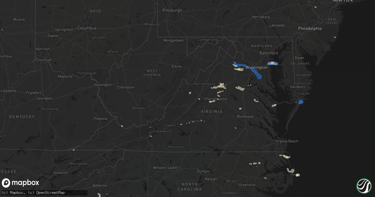
Hail Map in Virginia on June 12, 2026
Get this storm
June 12 map
$229
one time, instant access
Download today. No call, no setup
Keep the $229
Bought the map and want the full workflow? Apply the entire $229 to a subscription within 7 days. None of it is wasted.
Every map, not just this one
This buys you this map. Subscription and you get every map we run, in the markets you choose from a few cities to whole states to nationwide. Plus real-time alerts the moment a storm fires.
Contact data
Name, contact info, occupancy, even credit band for addresses in the footprint. You go from where it hit to who to call.
Become the source they trust
Unlimited branding weather history reports on demand. You already have the documented answer ready for the property owner, and you are the one who showed up with it.
Property data and RoofTrace estimates
Pull up any address you have got, its value and the exact code rules for that jurisdiction, straight from One Click Code. Then RoofTrace estimates the squares, pitch, and roof value, priced the way you price.
Storm reports in Virginia
Virginia
| Date | Description |
|---|---|
| 06/12/20266:55 PM CDT | Large tree branch down in reedville in northumberland county... Va. |
| 06/12/20266:31 PM CDT | Outflow winds from thunderstorms downed a large tree that blocked both lanes on belair road. |
| 06/12/20266:30 PM CDT | Large tree downed at intersection of weems rd and christ church rd. |
| 06/12/20266:29 PM CDT | Outflow winds from thunderstorms downed one tree near the intersection of collins ferry road and epsons road... And blocked the roadway. |
| 06/12/20266:27 PM CDT | Outflow winds from thunderstorms downed a tree on horsepasture price road. |
| 06/12/20266:25 PM CDT | Tree downed by outflow winds from thunderstorms into the road... And blocked half of the roadway. |
| 06/12/20266:22 PM CDT | Outflow winds from thunderstorms downed a tree onto renan road and blocked one lane of the roadway. |
| 06/12/20266:20 PM CDT | Large trees downed on wharf rd and essex mill at tidewater rd. |
| 06/12/20266:15 PM CDT | Outflow boundary winds caused a tree to fall onto gladys road... In gladys... Va... Blocking the entire road. Time is estimated from radar. |
| 06/12/20266:15 PM CDT | Tree fell onto lime plant road... Near appomattox... Va. Time is estimated from radar. |
| 06/12/20266:12 PM CDT | Tree down near lomand dr and urbanna road. |
| 06/12/20266:09 PM CDT | Large tree downed by thunderstorm winds on bateman ridge road. Report on social media. |
| 06/12/20266:07 PM CDT | Outflow boundary winds caused a tree to fall onto northbound lane of mansion bridge road... In altavista... Va. |
| 06/12/20266:06 PM CDT | A large tree... Power lines... And multiple tree branches fell at catharpin road and fallen oaks place due to thunderstorm winds. Time estimated via radar. |
| 06/12/20266:05 PM CDT | Outflow boundary winds caused a large tree to fall near the intersection of dearing ford road and tardy mountain road in altavista... Va... Partially blocking the road. |
| 06/12/20266:04 PM CDT | Tree down at vale road and vale station road. |
| 06/12/20266:02 PM CDT | Tree down at alder woods drive and joseph seiwick drive. |
| 06/12/20265:56 PM CDT | Multiple reports of trees and powerlines down in far western louisa county... Particularly near troy. There is also a large cluster of power outages. |
| 06/12/20265:53 PM CDT | Outflow winds from thunderstorm downed a tree... Which landed on a power line. |
| 06/12/20265:53 PM CDT | A local report indicates 67 MPH wind near Dulles Intl Airport |
| 06/12/20265:52 PM CDT | Trees reported down along thomas jefferson parkway. |
| 06/12/20265:45 PM CDT | Outflow winds downed one tree on harbor village way. |
| 06/12/20265:45 PM CDT | Trees downed on scotchtown rd south of chiswell ln. |
| 06/12/20265:45 PM CDT | Social media picture shows tree down across cedarberry lane in forest... Va. |
| 06/12/20265:40 PM CDT | Outflow from thunderstorm blew down two tents at a local church. A number of injuries were reported... Some critical. |
| 06/12/20265:40 PM CDT | Virginia tech mesonet in middleburg |
| 06/12/20265:40 PM CDT | *** 1 fatal... 22 inj *** corrects previous tstm wnd dmg report from 2 s moneta. Corrects previous tstm wnd dmg report from 2 s moneta. Outflow from thunderstorm blew d |
| 06/12/20265:40 PM CDT | *** 1 fatal... 23 inj *** corrects previous tstm wnd dmg report from 2 s moneta. Outflow from thunderstorm blew down one tent at a local church. One fatality and 23 inj |
| 06/12/20265:37 PM CDT | Outflow winds from thunderstorms downed a tree on indian run trail. |
| 06/12/20265:36 PM CDT | Several trees down along route 50 near middleburg. |
| 06/12/20265:35 PM CDT | Outflow boundary winds caused a power line to fall across the road near the intersection of middle valley road and green ridge drive in hardy... Va. Time is estimated f |
| 06/12/20265:35 PM CDT | Trees downed at south church ln. Time radar-estimated. |
| 06/12/20265:32 PM CDT | Outflow winds from thunderstorms blew a tree down in the 200 block of sample road. The tree completely blocked the road. |
| 06/12/20265:29 PM CDT | Large tree downed by thunderstorm winds... Blocking the entire road... And hit a nearby power pole. |
| 06/12/20265:29 PM CDT | Tree downed by thunderstorm winds onto a power line on 15th street ne. |
| 06/12/20265:26 PM CDT | Power line downed by thunderstorm winds caught a nearby tree on fire on hollyhock road nw. |
| 06/12/20265:25 PM CDT | Large tree branches downed onto ladysmith road at us-1. Time radar-estimated. |
| 06/12/20265:23 PM CDT | Multiple trees reported down at the old mill golf resort in carol county virginia. |
| 06/12/20265:20 PM CDT | Trees downed along i-95 at mile marker 113 southbound. |
| 06/12/20265:19 PM CDT | Several trees were downed by thunderstorm winds in the town of draper. |
| 06/12/20265:18 PM CDT | A few trees were downed by thunderstorm winds in the town of pulaski. |
| 06/12/20265:18 PM CDT | Tree downed by thunderstorm winds onto a power line. |
| 06/12/20265:15 PM CDT | At least 18 different reports of a tree down across the northern part of franklin county... Due to outflow boundary winds. |
| 06/12/20265:15 PM CDT | Tree downed by thunderstorm winds and then fell onto a power line. |
| 06/12/20265:15 PM CDT | Lightning struck a tree... Which then fell onto a power line near meadow view apartments. |
| 06/12/20265:12 PM CDT | Tree downed by thunderstorm winds on interstate 81 near mile marker 136.1. |
| 06/12/20265:10 PM CDT | One tree down due to thunderstorm winds at the intersection of misty hill lane and rockfish road. |
| 06/12/20265:09 PM CDT | Large tree down at endless caverns road. |
| 06/12/20265:06 PM CDT | One tree down due to thunderstorm winds at the intersection of lyndhurst road and schages lane. |
| 06/12/20265:05 PM CDT | One tree down due to thunderstorm winds along the 900 block of howardsville turnpike. |
| 06/12/20265:05 PM CDT | One tree down due to thunderstorm winds at the intersection of china clay road and patton farm road. |
| 06/12/20265:04 PM CDT | Tree down at route 29 and carpenters mill road. |
| 06/12/20265:04 PM CDT | One tree down due to thunderstorm winds along hall school road. |
| 06/12/20265:02 PM CDT | Tree down on clubhouse road. |
| 06/12/20265:00 PM CDT | A few trees and power lines reported down across stuarts draft area. |
| 06/12/20265:00 PM CDT | Trees down in bumpass. Time estimated from radar. |
| 06/12/20264:55 PM CDT | Multiple trees and branches down near cee cee turner trail and broadway. |
| 06/12/20264:53 PM CDT | Corrects previous tstm wnd dmg report from 2 nne gladesboro. 911 call center reported a tree down off of danville pike road |
| 06/12/20264:53 PM CDT | 911 call center reported a tree down along highway 58 in caroll county virginia. |
| 06/12/20264:50 PM CDT | Multiple reports of trees down across southern madison co. |
| 06/12/20264:45 PM CDT | Social media post of multiple trees snapped in half on the galax municipal golf course in galax virginia. |
| 06/12/20264:45 PM CDT | Tree fell onto a fence near glendale road in galax... Va. Time is estimated from radar. |
| 06/12/20264:40 PM CDT | Reports of multiple trees down across the area in spotsylvania co. |
| 06/12/20264:37 PM CDT | Multiple trees down near woodstock at w high street and s lee street. |
| 06/12/20264:30 PM CDT | Large tree branch downed by thunderstorm winds... And brought down a power line which landed across the road. |
| 06/12/20264:29 PM CDT | Tree down and covering both lanes on big stoney creek road in ripplemead. |
| 06/12/20264:28 PM CDT | Trees down near sherman road in woodstock. |
| 06/12/20264:28 PM CDT | Tree down near brown farms road. |
| 06/12/20264:28 PM CDT | Reports of multiple trees down across the area in spotsylvania co. |
| 06/12/20264:15 PM CDT | Multiple trees downed onto woodford road in woodford. Time radar-estimated. |
| 06/12/20264:07 PM CDT | Multiple reports of fallen trees near winchester street in city of fredericksburg. |
| 06/12/20264:06 PM CDT | Multiple reports of trees and power lines down near linden ave in the city of fredericksburg. |
| 06/12/20263:45 PM CDT | A large tree was down along ingleside drive and washington street. |
| 06/12/20263:45 PM CDT | Tree reported on roadway near hazel grove. |
| 06/12/20263:43 PM CDT | A local report indicates 1.00 inch wind near 1 SW Woolsey |
| 06/12/20263:30 PM CDT | Power outages due to storm damage. Time estimated based on radar. |
| 06/12/20263:25 PM CDT | Tree down reported at richards ferry road and beach road. |
| 06/12/20263:20 PM CDT | Tree down reported near bear wallow road. |
| 06/12/20263:02 PM CDT | Tree down reported at cabin branch road and cliff mills road. |
| 06/12/20262:33 PM CDT | Dispatch reported numerous downed trees. |
| 06/11/20269:00 PM CDT | Multiple trees down in new church in accomack county. Time estimated from radar. |
| 06/11/20268:30 PM CDT | Multiple trees down near the intersection of horsey rd and neal park road and near arcadia high school. Time estimated from radar. |
| 06/11/20268:30 PM CDT | Asos station kwal wallops island. |
| 06/11/20268:12 PM CDT | Trees and powerlines down. |
| 06/11/20268:09 PM CDT | Measured via handheld anemometer. |
| 06/11/20267:38 PM CDT | Power lines down. |
All States Impacted by Hail Map on June 12, 2026
Cities Impacted by Hail Map on June 12, 2026
- Kenton, TN
- Trimble, TN
- Friendship, TN
- Booker, TX
- Perryton, TX
- Follett, TX
- Laverne, OK
- Balko, OK
- Lexington, TN
- Brighton, TN
- Covington, TN
- May, OK
- Buffalo, OK
- Lamar, OK
- Mcalester, OK
- Green Pond, SC
- Yemassee, SC
- Nellis, WV
- Ridgeview, WV
- Costa, WV
- Peytona, WV
- Ashford, WV
- Winifrede, WV
- Cabin Creek, WV
- Hernshaw, WV
- Julian, WV
- Comfort, WV
- Round O, SC
- Harrogate, TN
- Eskdale, WV
- Ewing, VA
- Mount Nebo, WV
- Summersville, WV
- Tazewell, TN
- Cloudcroft, NM
- Madison, VA
- Banco, VA
- Reva, VA
- Ludowici, GA
- Summerville, SC
- Ladson, SC
- Mount Hope, WV
- Haywood, VA
- Van Horn, TX
- Fairfield, MT
- Renick, WV
- Arcadia, FL
- Fredericksburg, VA
- Scarbro, WV
- Meadow Bridge, WV
- Grassy Meadows, WV
- Richardsville, VA
- Huger, SC
- Frenchtown, NJ
- Flemington, NJ
- Pittstown, NJ
- Haymarket, VA
- Broad Run, VA
- Spring Dale, WV
- Fort Stockton, TX
- Fort Shaw, MT
- Swiss, WV
- Belva, WV
- The Plains, VA
- Jewell Ridge, VA
- Raysal, WV
- Spotsylvania, VA
- Alpine, TX
- Ronceverte, WV
- Lewisburg, WV
- Caldwell, WV
- Alderson, WV
- Poplar Grove, AR
- Gainesville, VA
- Catharpin, VA
- Moro, AR
- Weed, NM
- Deerfield, VA
- Manassas, VA
- Centreville, VA
- Chantilly, VA
- Vaughn, MT
- Middleburg, VA
- Stanardsville, VA
- West Cornwall, CT
- Sharon, CT
- Locust Grove, VA
- Stafford, VA
- Sun River, MT
- Power, MT
- Great Falls, MT
- Punta Gorda, FL
- Sebring, FL
- Welch, WV
- Hillsboro, WV
- Sacramento, NM
- Zolfo Springs, FL
- Marvell, AR
- Nassau, NY
- Old Chatham, NY
- Malden Bridge, NY
- Nanjemoy, MD
- West Augusta, VA
- Lake Wales, FL
- Dundee, FL
- Culpeper, VA
- Hood, VA
- Oakpark, VA
- Brightwood, VA
- Pratts, VA
- Aroda, VA
- Fayette, AL
- Brainard, NY
- Greenville, VA
- Stuarts Draft, VA
- Milford, VA
- Hustle, VA
- Elkton, VA
- Dyke, VA
- Northport, AL
- Orange, VA
- Radiant, VA
- Locust Dale, VA
- Haines City, FL
- Kissimmee, FL
- Manahawkin, NJ
- Staffordsville, VA
- Ruckersville, VA
- Barboursville, VA
- Rochelle, VA
- Marathon, TX
- Alamogordo, NM
- Brooklet, GA
- Champlain, VA
- South Kent, CT
- Kent, CT
- Wingdale, NY
- Charlottesville, VA
- Jesup, GA
- Lakeville, CT
- Bedford, VA
- Raton, NM
- Somerset, VA
- Trinidad, CO
- Statesboro, GA
- Thaxton, VA
- North Garden, VA
- Belt, MT
- Upperville, VA
- Hiwassee, VA
- Draper, VA
- Tappahannock, VA
- Salisbury, CT
- Falls Village, CT
- Keswick, VA
- Pulaski, VA
- Marshall, VA
- Franklin Lakes, NJ
- Oakland, NJ
- Maywood, NJ
- Lodi, NJ
- Paramus, NJ
- Saddle Brook, NJ
- Fair Lawn, NJ
- Rochelle Park, NJ
- Gaylordsville, CT
- New Milford, CT
- Woodbury, CT
- Bethlehem, CT
- Nutley, NJ
- Glen Ridge, NJ
- Bloomfield, NJ
- Montclair, NJ
- Horse Shoe, NC
- Mills River, NC
- Harmony, ME
- Lowry, VA
- Goode, VA
- Montpelier, VA
- Thomaston, CT
- Watertown, CT
- Madison Heights, VA
- Amherst, VA
- Cottondale, AL
- Tuscaloosa, AL
- Forest, VA
- Ashland, VA
- Secaucus, NJ
- East Rutherford, NJ
- North Bergen, NJ
- Lyndhurst, NJ
- West New York, NJ
- Weehawken, NJ
- Carlstadt, NJ
- Union City, NJ
- Clifton, NJ
- Moneta, VA
- Vinton, VA
- Herndon, VA
- Leesburg, VA
- Aldie, VA
- Sterling, VA
- Reston, VA
- Ashburn, VA
- Bluemont, VA
- Oakton, VA
- Fairfax, VA
- Round Hill, VA
- Hendersonville, NC
- Middlebury, CT
- Waterbury, CT
- Oakville, CT
- Ocate, NM
- Lynchburg, VA
- Vienna, VA
- Springfield, VA
- Falls Church, VA
- Annandale, VA
- Alexandria, VA
- Arlington, VA
- Mill Spring, NC
- Sylvania, GA
- Lancaster, VA
- Heathsville, VA
- Concord, VA
- Baxley, GA
- Wagon Mound, NM
- Glen Allen, VA
- Rockville, VA
- La Plata, MD
- Fort Washington, MD
- Brandywine, MD
- Clinton, MD
- Accokeek, MD
- Waldorf, MD
- White Plains, MD
- Pomfret, MD
- Stanford, MT
- Geyser, MT
- Burgess, VA
- Capulin, NM
- Flat Rock, NC
- Saluda, NC
- Etowah, NC
- Pisgah Forest, NC
- Marietta, SC
- Zirconia, NC
- Des Moines, NM
- Annapolis, MD
- Crownsville, MD
- Arnold, MD
- Solano, NM
- Grenville, NM
- Boise City, OK
- Ruston, LA
- Amelia Court House, VA
- Ford, VA
- Roy, NM
- Severna Park, MD
- Edgewater, MD
- Davidsonville, MD
- Grambling, LA
- Campo, CO
- Temperanceville, VA
- Stevensville, MD
- Gambrills, MD
- Elkhart, KS
- Chester, MD
- Clayton, NM
- Keyes, OK
- Wallops Island, VA
- Horntown, VA
- Oak Hall, VA
- Atlantic, VA
- New Church, VA
- Tribune, KS
- Goodwell, OK
- Texhoma, OK
- Richfield, KS
- Walsh, CO
- Dalhart, TX
- Moriarty, NM
- Roxobel, NC
- Scotland Neck, NC
- Rolla, KS
- Guymon, OK
- Stratford, TX
- Mosquero, NM
- Aulander, NC
- Kelford, NC
- Edgewood, NM
- Hooker, OK
- Gruver, TX
- Texhoma, TX
- Amistad, NM
- Sedan, NM
- Texline, TX
- Tijeras, NM
- Stanley, NM
- Rich Square, NC
- Colerain, NC
- Ahoskie, NC
- Weskan, KS
- Sharon Springs, KS
- Spearman, TX
- Hardesty, OK
- Conchas Dam, NM
- South Mills, NC
- Nara Visa, NM
- Turpin, OK
- Sunray, TX
- Beaver, OK
- Moyock, NC
- Stinnett, TX
- Morse, TX
- Hartley, TX
- Logan, NM
- Channing, TX
- Las Vegas, NM
- Maple, NC
- Currituck, NC
- Trementina, NM
- Shawboro, NC
- Barco, NC
- Wallace, KS
- Winona, KS
- Edson, KS
- Coinjock, NC
- Plymouth, NC
- Vega, TX
- Adrian, TX
- Plains, KS
- Colby, KS
- Monument, KS
- Levant, KS
- Vaughn, NM
- Nags Head, NC
- Manteo, NC
- Manns Harbor, NC
- Kitty Hawk, NC
- Miami, TX
- Dumas, TX
- Gate, OK
- Meade, KS
- Oakley, KS
- Kill Devil Hills, NC
- Scott City, KS
- Forgan, OK
- Grinnell, KS
- Masterson, TX
- Amarillo, TX
- Rosston, OK
- Healy, KS
- Canadian, TX
- Wanchese, NC
- Dodge City, KS
- Protection, KS
- Fowler, KS
- Ashland, KS
- Coldwater, KS
- Spearville, KS
- Ensign, KS
- Englewood, KS
- Minneola, KS
- Ford, KS
- Wright, KS
- Higgins, TX
- Fritch, TX
- Panhandle, TX
- Borger, TX
- Skellytown, TX
- Grainfield, KS
- Gove, KS
- Park, KS
- Freedom, OK
- Mooreland, OK
- Lake City, KS
- Alva, OK
- Wilmore, KS
- Pampa, TX
- White Deer, TX
- Waynoka, OK
- Hardtner, KS
- Tucumcari, NM
- Burlington, OK
- Cherokee, OK
- Chester, OK
- Dacoma, OK
- Leedey, OK
- Butler, OK
- Aline, OK
- Fairview, OK
- Cleo Springs, OK
- Carmen, OK
- Helena, OK
- Jet, OK
- Amorita, OK
- Goltry, OK
- Wakita, OK
- Pond Creek, OK
- Manchester, OK
- Nash, OK
- Medford, OK
- Ringwood, OK
- Lees Summit, MO
- Grain Valley, MO
- Carrier, OK
- Enid, OK
- Kremlin, OK
- Meno, OK
- Ames, OK
- Bates City, MO
- Oak Grove, MO
- Garber, OK
- Kingsville, MO
- Strasburg, MO
- Pleasant Hill, MO
- Hunter, OK
- Wellington, KS
- Belle Plaine, KS
- Oxford, KS
- Udall, KS
- Douglas, OK
- Holden, MO
- Waukomis, OK
- Marshall, OK
- Fairmont, OK
- Anselmo, NE
- Covington, OK
- Billings, OK
- Hennessey, OK
- Burwell, NE
- Centerview, MO
- Eustis, NE
- Cozad, NE
- Lucien, OK
- Taylor, NE
- Sargent, NE
- Alma, MO
- Corder, MO
- Lone Jack, MO
- Brewster, NE
- Dunning, NE
- Warrensburg, MO
- Lexington, NE
- Elwood, NE
- Farnam, NE
- Callaway, NE
- Ericson, NE
- Purdum, NE
- El Dorado Springs, MO
- Gothenburg, NE
- Knob Noster, MO
- Bartlett, NE
- Spalding, NE
- Leeton, MO
- Windsor, MO
- Odessa, MO
- Elyria, NE
- Ord, NE
- Eddyville, NE
- Petersburg, NE
- Albion, NE
- Green Ridge, MO
- Stapleton, NE
- Perry, OK
- Lamont, OK
- Tonkawa, OK
- Sumner, NE
- Scotia, NE
- Curtis, NE
- Overton, NE
- Halsey, NE
- Stockville, NE
- Greeley, NE
- Primrose, NE
- Elgin, NE
- Broken Bow, NE
- Tilden, NE
- Meadow Grove, NE
- Oakdale, NE
- Moorefield, NE
- Madison, NE
- Battle Creek, NE
- Cedar Rapids, NE
- Comstock, NE
- Walters, OK
- Centerville, KS
- Norfolk, NE
- North Loup, NE
- Saint Edward, NE
- Palmer, NE
- Archer, NE
- Westerville, NE
- Genoa, NE
- Ansley, NE
- Temple, OK
- Bristow, OK
- Okemah, OK
- Stanton, NE
- Petrolia, TX
- Byers, TX
- Wolbach, NE
- Pilger, NE
- Platte Center, NE
- Humphrey, NE
- Monroe, NE
- Lindsay, NE
- Fullerton, NE
- Clarks, NE
- Central City, NE
- Belgrade, NE
- Hastings, OK
- Waurika, OK
- Garden City, MO


