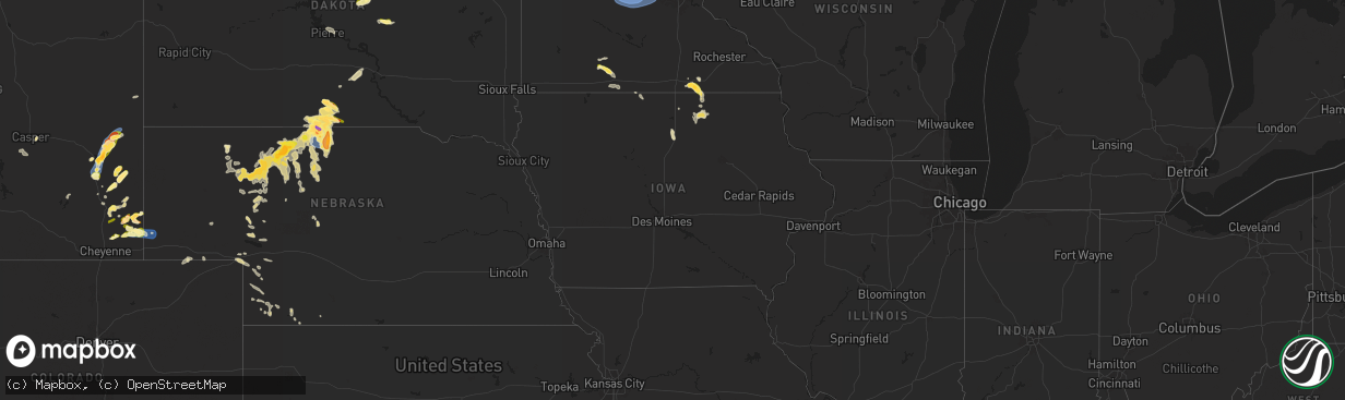
Hail Map in Iowa on June 12, 2025
The weather event in Iowa on June 12, 2025 includes Hail and Wind maps. 17 states and 316 cities were impacted and suffered possible damage. The total estimated number of properties impacted is 159.
Want more than just the map?
Turn this storm into a full workflow.
- Owner + property data so you know who to knock
- OnDemand branded weather history reports to win the "did we even have hail?" argument
- RoofTrace estimate so reps stop guessing numbers at the door
Bought this map? Upgrade within 7 days and we'll credit the $230. (10-15 min setup call)
Hail
Wind
159
Estimated number of impacted properties by a 1.00" hail or larger0
Estimated number of impacted properties by a 1.75" hail or larger0
Estimated number of impacted properties by a 2.50" hail or largerStorm reports in Iowa
Iowa
| Date | Description |
|---|---|
| 06/11/20258:50 PM CDT | Rochester news station passed on photos of two mature ponderosa pines that fell onto highway 218 north of floyd. Time estimated on radar. |
| 06/11/20258:36 PM CDT | Photo of fallen large tree. |
| 06/11/20257:30 PM CDT | A third of a large willow tree blown down. |
All States Impacted by Hail Map on June 12, 2025
Cities Impacted by Hail Map on June 12, 2025
- Beeville, TX
- Goliad, TX
- Refugio, TX
- Lagrange, WY
- Hawk Springs, WY
- Mission, SD
- Okreek, SD
- Cheyenne, WY
- Winner, SD
- Tallulah, LA
- Utica, MS
- Vicksburg, MS
- Taft, TX
- Robstown, TX
- Meriden, WY
- Albin, WY
- Portland, TX
- Cotopaxi, CO
- Loveland, CO
- Burns, WY
- Marshall, TX
- Aransas Pass, TX
- Albemarle, NC
- Locust, NC
- Oakboro, NC
- Uvalde, TX
- Homosassa, FL
- Concan, TX
- Lecanto, FL
- Rio Frio, TX
- Corpus Christi, TX
- Kennebec, SD
- Presho, SD
- Hamill, SD
- Picacho, NM
- Chugwater, WY
- Pine Bluffs, WY
- Forsyth, MT
- Bighorn, MT
- Saint Francis, SD
- Reliance, SD
- Hysham, MT
- Odin, MN
- Mountain Lake, MN
- Yoder, WY
- Wheatland, WY
- Bushnell, NE
- Fort Sumner, NM
- Mansfield, SD
- Northville, SD
- Mellette, SD
- Butterfield, MN
- Scotts Hill, TN
- Bath Springs, TN
- Port Aransas, TX
- Harrisburg, NE
- Brandon, MS
- Warner, SD
- Trimont, MN
- Ashton, SD
- Valentine, NE
- Liberty, MS
- Smithdale, MS
- Decaturville, TN
- Creswell, NC
- Ormsby, MN
- Dowagiac, MI
- Morriston, FL
- Williston, FL
- Pelahatchie, MS
- Medina, TN
- Stratford, SD
- Lavinia, TN
- Milan, TN
- Veteran, WY
- Crookston, NE
- Volborg, MT
- Fort Laramie, WY
- Grulla, TX
- Mission, TX
- Albert Lea, MN
- Linn, TX
- Roper, NC
- Conde, SD
- Turton, SD
- Otter, MT
- Trenton, FL
- Glenville, MN
- Cedar Grove, TN
- Jackson, TN
- Edinburg, TX
- Newberry, FL
- Bronson, FL
- Elida, NM
- Sparks, NE
- Maben, MS
- Austin, MN
- Jay Em, WY
- Broadus, MT
- Sturgis, MS
- Starkville, MS
- Truman, MN
- Welcome, MN
- Decatur, MI
- Kilgore, NE
- Ideal, SD
- Witten, SD
- Snyder, CO
- Latimer, IA
- Sheffield, IA
- Alexander, IA
- Ceylon, MN
- Sherburn, MN
- Pheba, MS
- Garciasville, TX
- Benson, MN
- Montevideo, MN
- Danvers, MN
- Sullivan City, TX
- Fairmont, MN
- Nenzel, NE
- Olive, MT
- Wood Lake, NE
- Cody, NE
- Merino, CO
- Sterling, CO
- Henning, TN
- Thornton, IA
- Covington, TN
- Appleton, MN
- Glendo, WY
- Hartville, WY
- Portales, NM
- Pierre, SD
- Ripley, TN
- Lyle, MN
- Maynard, MN
- Murdock, MN
- Lake Butler, FL
- Brooker, FL
- Rose Creek, MN
- Clara City, MN
- Stewart, MN
- Brownton, MN
- Glencoe, MN
- Buffalo Lake, MN
- Hutchinson, MN
- Orient, SD
- Highmore, SD
- Onida, SD
- Forest, MS
- Raymond, MN
- Peetz, CO
- Saint Ansgar, IA
- Hargill, TX
- Silver Lake, MN
- Winsted, MN
- Lester Prairie, MN
- Hamburg, MN
- Norwood Young America, MN
- Young America, MN
- Plato, MN
- Fleming, CO
- Holabird, SD
- Sidney, NE
- Stacyville, IA
- Rogers, NM
- Edcouch, TX
- Manville, WY
- Shawnee, WY
- Weslaco, TX
- Donna, TX
- Elsa, TX
- La Villa, TX
- Mercedes, TX
- Garrett, WY
- Bosler, WY
- Seneca, SD
- Prinsburg, MN
- Manly, IA
- Floyd, NM
- Osage, IA
- Broadwater, NE
- New Germany, MN
- Watertown, MN
- Mayer, MN
- Montrose, MN
- Cologne, MN
- Waconia, MN
- Merriman, NE
- Thedford, NE
- Halls, TN
- Blomkest, MN
- Whitman, NE
- Little Cedar, IA
- Pontotoc, MS
- Saint Bonifacius, MN
- Ree Heights, SD
- Nora Springs, IA
- Swea City, IA
- Ledyard, IA
- Buffalo Center, IA
- Rudd, IA
- Rockford, IA
- Lodgepole, NE
- Crook, CO
- Floyd, IA
- Lusk, WY
- Charles City, IA
- Orchard, IA
- Lakota, IA
- Baldwyn, MS
- Marietta, MS
- Casper, WY
- Bingham, NE
- Ashby, NE
- Ovid, CO
- Miller, SD
- Julesburg, CO
- Big Springs, NE
- Arthur, NE
- Ellsworth, NE
- Hyannis, NE
- Lewellen, NE
- Lemoyne, NE
- Rushville, NE
- Seneca, NE
- Venango, NE
- Holyoke, CO
- Tishomingo, MS
- Booneville, MS
- Keystone, NE
- Grant, NE
- Madrid, NE
- Champion, NE
- Imperial, NE
- Gordon, NE
- Mullen, NE
- Parks, NE
- Enders, NE
- Lance Creek, WY
- Benkelman, NE
- Stapleton, NE
- Wauneta, NE
- Palisade, NE
- Trenton, NE
- Fort Pierre, SD
- Milan, MN
- Saint James, MN
- Brownsdale, MN
- Indianola, NE
- Atwood, KS
- Oberlin, KS
- Herndon, KS
- Culbertson, NE
- McDonald, KS
- Pavillion, WY
- Bird City, KS
- Fort Supply, OK
- Colby, KS
- Ludell, KS
- Wagner, SD
- Guernsey, WY
- Mills, NE
- Emmons, MN
- Lake Andes, SD
- Worthing, SD
- Lake Park, IA
- Bonesteel, SD
- Canton, SD
- Sibley, IA
- Twin Lakes, MN
- Elmore, MN
- Spirit Lake, IA
- Menno, SD
- Springview, NE
- Doon, IA
- Inwood, IA
- Lennox, SD
- Hurley, SD
- Little Rock, IA
- Estherville, IA
- Bricelyn, MN
- Scotland, SD
- George, IA
- Olivet, SD
- Herrick, SD
- Harris, IA
- Dolliver, IA
- Burke, SD
- Alvord, IA
- Ocheyedan, IA
- Davis, SD
- Kiester, MN
- Fairfax, SD
- Armstrong, IA
- Freeman, SD
- Gregory, SD
- Oakley, KS
- Monument, KS
- Butler, OK
- Quinter, KS
- Grinnell, KS
- Utica, KS
- Lookeba, OK
- Hinton, OK
- Geary, OK
- New Iberia, LA
- Enterprise, LA
- Harrisonburg, LA
- Binger, OK
- Gracemont, OK
- Ninnekah, OK
- Rush Springs, OK
- Jetmore, KS
- Marlow, OK


