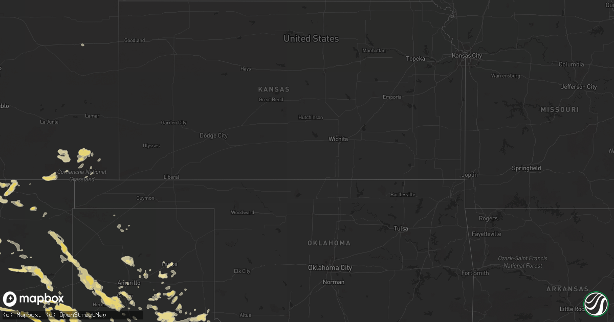
Hail Map in North Carolina on June 12, 2012
Get this storm
June 12 map
$229
one time, instant access
Download today. No call, no setup
Keep the $229
Bought the map and want the full workflow? Apply the entire $229 to a subscription within 7 days. None of it is wasted.
Every map, not just this one
This buys you this map. Subscription and you get every map we run, in the markets you choose from a few cities to whole states to nationwide. Plus real-time alerts the moment a storm fires.
Contact data
Name, contact info, occupancy, even credit band for addresses in the footprint. You go from where it hit to who to call.
Become the source they trust
Unlimited branding weather history reports on demand. You already have the documented answer ready for the property owner, and you are the one who showed up with it.
Property data and RoofTrace estimates
Pull up any address you have got, its value and the exact code rules for that jurisdiction, straight from One Click Code. Then RoofTrace estimates the squares, pitch, and roof value, priced the way you price.
Storm reports in North Carolina
North Carolina
| Date | Description |
|---|---|
| 06/12/20125:00 PM CDT | Tree down. |
| 06/12/20123:55 PM CDT | A public report first indicated trees down in ellenboro. The ellenboro volunteer fire department said not aware of any trees down around ellenboro...but confirmed trees |
| 06/12/20123:45 PM CDT | Large tree blocking the road about 200 feet northwest of the intersection of highway 221 and south pea ridge road which is on the east side of henrietta. |
| 06/11/20129:15 PM CDT | Two powerlines were brought down by fallen limbs between rockwell and gold hill. |
| 06/11/20129:12 PM CDT | Tree down along hwy 8 and gentry road. |
| 06/11/20128:55 PM CDT | Tree down at corner of 704 east and steele rd. |
| 06/11/20128:50 PM CDT | Two powerlines down in the far western part of rowan county. |
| 06/11/20128:50 PM CDT | Fallen limbs brought down a powerline in east spencer. |
| 06/11/20127:56 PM CDT | 2 trees down and part of a barn blown down on edwards road near mocksville. |
| 06/11/20127:54 PM CDT | A spotter near sheffield had a wind gust near 60 mph. He saw and heard trees snapping and crashing to the ground. No hail. |
| 06/11/20127:50 PM CDT | 2 trees down. |
All States Impacted by Hail Map on June 12, 2012
Cities Impacted by Hail Map on June 12, 2012
- Weston, CO
- Franklin, TX
- Floyd, NM
- House, NM
- Caputa, SD
- Rapid City, SD
- Rising Star, TX
- Cisco, TX
- Quanah, TX
- Dimmitt, TX
- Nazareth, TX
- Thorndale, TX
- Lexington, TX
- Rockdale, TX
- Mill Spring, NC
- Friona, TX
- Kingsbury, TX
- Seguin, TX
- Trementina, NM
- Odessa, TX
- Ridgeland, SC
- Florien, LA
- Breckenridge, TX
- Graham, TX
- Newcastle, TX
- Pritchett, CO
- Springfield, CO
- Palestine, TX
- Jacksonville, TX
- Tulia, TX
- Raton, NM
- McDade, TX
- Elgin, TX
- Quitaque, TX
- Silverton, TX
- Hayes Center, NE
- Jal, NM
- Albany, TX
- Childress, TX
- Memphis, TX
- San Jon, NM
- Miles, TX
- Canyon, TX
- Seymour, TX
- Campo, CO
- Clovis, NM
- Pampa, TX
- Haskell, TX
- Throckmorton, TX
- Plains, TX
- Whiteface, TX
- Goldsmith, TX
- Mcalister, NM
- Ogallala, NE
- Hereford, TX
- Kountze, TX
- Willacoochee, GA
- Pearson, GA
- Nicholls, GA
- Ambrose, GA
- Douglas, GA
- Tennessee Colony, TX
- Montalba, TX
- Belle Fourche, SD
- Dublin, TX
- Olton, TX
- Springlake, TX
- Oakwood, TX
- Happy, TX
- Alto, TX
- Rusk, TX
- Cleburne, TX
- Grandview, TX
- Portales, NM
- Melrose, NM
- Goodrich, TX
- Livingston, TX
- Midland, TX
- Amistad, NM
- Masterson, TX
- Vale, SD
- Rogers, NM
- Causey, NM
- Ralls, TX
- Baxley, GA
- Logan, NM
- Vega, TX
- Adrian, TX
- Nara Visa, NM
- Gonzales, TX
- Benkelman, NE
- Blooming Grove, TX
- Branson, CO
- Kim, CO
- Grady, NM
- Cannon Afb, NM
- Texico, NM
- Broadview, NM
- Farwell, TX
- Muleshoe, TX
- Bovina, TX
- Sudan, TX
- Andrews, TX
- Morton, TX
- Levelland, TX
- Conchas Dam, NM
- Midkiff, TX
- Big Lake, TX
- Conroe, TX
- Montgomery, TX
- Des Moines, NM
- Paxton, NE
- Woodville, TX
- Hillister, TX
- Cross Plains, TX
- Pine Ridge, SD
- Manderson, SD
- Sturgis, SD
- Milano, TX
- Caldwell, TX
- Rule, TX
- San Angelo, TX
- Trenton, NE
- Clarendon, TX
- Hazlehurst, GA
- Alma, GA
- Crowell, TX
- Waelder, TX
- Lovington, NM
- Hobbs, NM
- Lueders, TX
- Cleveland, TX
- Splendora, TX
- Stratton, NE
- Monahans, TX
- Kermit, TX
- Rochester, TX
- O'Brien, TX
- Comanche, TX
- Mullin, TX
- Zephyr, TX
- Jasper, TX
- Coldspring, TX
- Santa Rosa, NM
- Jonesboro, TX
- Hamilton, TX
- Max, NE
- Palisade, NE
- San Augustine, TX
- Lipan, TX
- Santo, TX
- Whitman, NE
- Hyannis, NE
- Strawn, TX
- Gordon, TX
- Wanblee, SD
- Scenic, SD
- Wall, SD
- Interior, SD
- Kadoka, SD
- Turkey, TX
- Lakeview, TX
- Stratford, TX
- Flomot, TX
- Matador, TX
- Seminole, TX
- Barstow, TX
- Groveton, TX
- Thrall, TX
- Big Spring, TX
- Knott, TX
- New Underwood, SD
- Custer, SD
- Elsie, NE
- Wauneta, NE
- Ranger, TX
- Mingus, TX
- Bryan, TX
- College Station, TX
- Marquez, TX
- Panhandle, TX
- Shepherd, TX
- New Waverly, TX
- Eunice, NM
- Monument, NM
- Groom, TX
- Bedias, TX
- Normangee, TX
- Leona, TX
- Ocate, NM
- Wagon Mound, NM
- Lovelady, TX
- Trinity, TX
- Coyanosa, TX
- Richards, TX
- Enders, NE
- White Deer, TX
- Gause, TX
- Amarillo, TX
- Saint Augustine, FL
- Harwood, TX
- Live Oak, FL
- Wellborn, FL
- Crane, TX
- Maljamar, NM
- Anderson, TX
- Willis, TX
- Italy, TX
- Lapwai, ID
- Culdesac, ID
- Carson, NM
- Paducah, TX
- Petersburg, TX
- Abernathy, TX
- Flatonia, TX
- Monticello, FL
- Tolar, TX
- Lockney, TX
- White Springs, FL
- Jasper, FL
- Maywood, NE
- Centerville, TX
- Jewett, TX
- Baird, TX
- Hermosa, SD
- Sidney, TX
- Blanket, TX
- Wallace, NE
- Imperial, NE
- Whitewood, SD
- Nisland, SD
- Greenville, FL
- Olney, TX
- Sunray, TX
- Fort Sumner, NM
- Fairfield, TX
- Spring, TX
- Magnolia, TX
- Tucumcari, NM
- Weinert, TX
- Kress, TX
- Plainview, TX
- Denver City, TX
- Coleman, TX
- East Palatka, FL
- Mullen, NE
- Ashby, NE
- Rutherfordton, NC
- Claude, TX
- Rustburg, VA
- Lynchburg, VA
- Concord, VA
- Timpson, TX
- Teague, TX
- Elkton, FL
- Culbertson, NE
- Iola, TX
- Colmesneil, TX
- Brookhaven, MS
- Dawson, TX
- Grapeland, TX
- Elkhart, TX
- Boncarbo, CO
- Trinidad, CO
- Reidsville, GA
- Coupland, TX
- Lenorah, TX
- Munday, TX
- Broaddus, TX
- Tryon, NE
- Stapleton, NE
- Seneca, NE
- Buffalo, TX
- Stamford, TX
- Hedley, TX
- Lelia Lake, TX
- Lincoln, TX
- Stephenville, TX
- Giddings, TX
- Roy, NM
- Solano, NM
- Crockett, TX
- Kennard, TX
- Pennington, TX
- Odonnell, TX
- Union Center, SD
- Holliday, TX
- Madrid, NE
- Cameron, TX
- New Caney, TX
- Pecos, TX
- Leesville, LA
- Draper, SD
- Granbury, TX
- Orlando, FL
- Winter Garden, FL
- Carbon, TX
- Gardendale, TX
- Pointblank, TX
- Folsom, NM
- Goree, TX
- Moran, TX
- Avoca, TX
- Dodson, TX
- Huntsville, TX
- Gatesville, TX
- Green Cove Springs, FL
- Wiergate, TX
- Windermere, FL
- Warren, TX
- Chester, TX
- Mount Airy, NC
- Dobson, NC
- Gustine, TX
- Westminster, SC
- Idalou, TX
- Brownwood, TX
- Burkett, TX
- De Leon, TX
- White River, SD
- Corsicana, TX
- Caddo, TX
- Littlefield, TX
- Grenville, NM
- Gorman, TX
- Thedford, NE
- Nixon, TX
- Leesville, TX
- Barry, TX
- Imperial, TX
- Yadkinville, NC
- Clayton, NM
- Hulett, WY
- Madison, FL
- Piedmont, SD
- Bluff Dale, TX
- Iowa Park, TX
- Electra, TX
- Purmela, TX
- Cushing, TX
- Gretna, VA
- Dickens, NE
- Vona, CO
- Tell, TX
- Grant, NE
- Carlton, TX
- Pep, TX
- East Bend, NC
- Boonville, NC
- Weatherford, TX
- Moscow, TX
- Long Valley, SD
- Garden City, TX
- Notrees, TX
- Smithville, TX
- Godley, TX
- Garita, NM
- New Smyrna Beach, FL
- Mims, FL
- Wortham, TX
- Deridder, LA
- Merryville, LA
- Athens, TX
- Denton, GA
- Lohn, TX
- Streetman, TX
- Buena Vista, NM
- Asotin, WA
- Anatone, WA
- Center, TX
- Cee Vee, TX
- Fairburn, SD
- Venango, NE
- Bastrop, TX
- Itasca, TX
- May, TX
- Woodson, TX
- Taylor, TX


