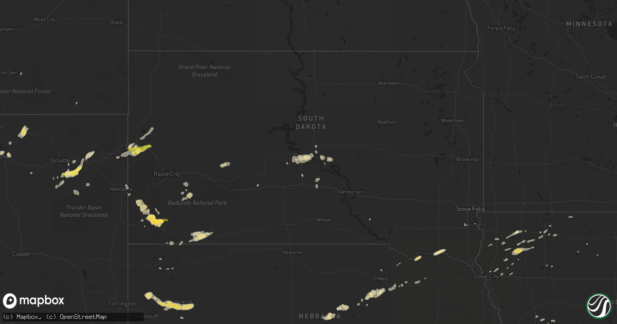
Hail Map in South Dakota on June 11, 2013
Get this storm
June 11 map
$229
one time, instant access
Download today. No call, no setup
Keep the $229
Bought the map and want the full workflow? Apply the entire $229 to a subscription within 7 days. None of it is wasted.
Every map, not just this one
This buys you this map. Subscription and you get every map we run, in the markets you choose from a few cities to whole states to nationwide. Plus real-time alerts the moment a storm fires.
Contact data
Name, contact info, occupancy, even credit band for addresses in the footprint. You go from where it hit to who to call.
Become the source they trust
Unlimited branding weather history reports on demand. You already have the documented answer ready for the property owner, and you are the one who showed up with it.
Property data and RoofTrace estimates
Pull up any address you have got, its value and the exact code rules for that jurisdiction, straight from One Click Code. Then RoofTrace estimates the squares, pitch, and roof value, priced the way you price.
Storm reports in South Dakota
South Dakota
| Date | Description |
|---|---|
| 06/11/20135:30 AM CDT | Person reported 2.5 to 3 foot diameter cottonwood tree had fallen across the road blocking both lanes |
| 06/11/20134:27 AM CDT | A local report indicates 60 MPH wind near S WEBSTER |
| 06/11/20134:10 AM CDT | Emergency manager reports numerous trees down in bristol. A couple of homes sustained minor damage with trees falling against them. |
| 06/11/20134:00 AM CDT | Emergency manager reports several trees down in andover with several large branches also broken off. |
| 06/11/20134:00 AM CDT | A local report indicates 71 MPH wind near ANDOVER |
| 06/11/20133:46 AM CDT | Tree knocked down onto powerline. |
| 06/11/20133:41 AM CDT | A local report indicates 60 MPH wind near 6 E DANFORTH |
| 06/11/20133:33 AM CDT | A local report indicates 66 MPH wind near 5 S RICHMOND LAKE REC A |
| 06/11/20133:00 AM CDT | Winds estimated to be at least 60 mph between cresbard and chelsea. |
| 06/11/20132:05 AM CDT | Sheriff office also reported tree branches down. Power is out in gettysburg as well. |
| 06/11/20131:20 AM CDT | A cabin on the east shore of the missouri river sustained significant damage. Time estimated by radar. |
| 06/11/20131:20 AM CDT | Fort pierre raws site. Time approximate. |
| 06/11/20131:00 AM CDT | 2 inch diameter tree brances down |
| 06/10/201311:45 PM CDT | Hail at least 1.5 inch. Still nickle sized hail on the ground this morning. Wind driven hail broke 2 windows on house and a car window. Also damaged screens and misc it |
| 06/10/201311:30 PM CDT | Pea to 1/2 inch hail with strong winds. |
| 06/10/201311:29 PM CDT | A local report indicates 1.25 inch wind near DOWNTOWN HOT SPRINGS |
| 06/10/201310:30 PM CDT | A local report indicates 60 MPH wind near 5 E PORCUPINE |
| 06/10/20139:57 PM CDT | A local report indicates 63 MPH wind near DOWNTOWN STURGIS |
| 06/10/20139:17 PM CDT | A local report indicates 1.00 inch wind near 9 W DOWNTOWN SPEARFISH |
| 06/10/20139:15 PM CDT | Some small hail around 1/2 inch with lots of wind...thunder and lightning. |
All States Impacted by Hail Map on June 11, 2013
Cities Impacted by Hail Map on June 11, 2013
- Buffalo, WY
- Ruthven, IA
- Dickens, IA
- Sorrento, FL
- Wyola, MT
- Parkman, WY
- Dayton, WY
- Casselberry, FL
- Winter Springs, FL
- Oviedo, FL
- Winter Park, FL
- Lodge Grass, MT
- Estero, FL
- Valparaiso, IN
- Irwin, IA
- Gillette, WY
- Sheridan, WY
- Chambers, NE
- Palmyra, NE
- Eagle, NE
- Everly, IA
- Spencer, IA
- Alliance, NE
- Angora, NE
- Musselshell, MT
- Roundup, MT
- Sanborn, IA
- Sheldon, IA
- Saint Xavier, MT
- Beulah, WY
- Princeton, MN
- Zimmerman, MN
- Banner, WY
- Clearmont, WY
- Mulberry, IN
- Custer, SD
- Edgemont, SD
- Hot Springs, SD
- Oral, SD
- Peterson, IA
- Sutherland, IA
- Spearfish, SD
- Frankfort, IN
- Molt, MT
- Paullina, IA
- Meriden, IA
- Cleghorn, IA
- Larrabee, IA
- Marcus, IA
- Orchard, NE
- Royal, NE
- Thermopolis, WY
- Worland, WY
- Scenic, SD
- Hermosa, SD
- Algona, IA
- Shepherd, MT
- Whitewood, SD
- Sundance, WY
- Lead, SD
- Rozet, WY
- Reed Point, MT
- Moorcroft, WY
- Yankton, SD
- Wounded Knee, SD
- Pine Ridge, SD
- Amelia, NE
- Ranchester, WY
- Niobrara, NE
- Brooksville, FL
- Floral City, FL
- Mount Dora, FL
- Apopka, FL
- Osceola, NE
- Pierson, IA
- Blunt, SD
- Inverness, FL
- Stromsburg, NE
- Polk, NE
- Broadview, MT
- Kouts, IN
- Story, WY
- Big Timber, MT
- Rapelje, MT
- Orlando, FL
- La Vernia, TX
- Seguin, TX
- Sanford, FL
- Crow Agency, MT
- New Underwood, SD
- Caputa, SD
- Eustis, FL
- Primghar, IA
- Fort Pierre, SD
- Oneill, NE
- Arvada, WY
- Royal, IA
- La Crosse, IN
- Sycamore, IL
- Maple Park, IL
- Schneider, IN
- Demotte, IN
- Lake Village, IN
- Lowell, IN
- Pierre, SD
- Whitney, NE
- Leesburg, FL
- Okahumpka, FL
- Holcomb, IL
- Stillman Valley, IL
- Clare, IL
- Rochelle, IL
- Lindenwood, IL
- Malta, IL
- Monroe Center, IL
- Esmond, IL
- Kirkland, IL
- Davis Junction, IL
- Brewster, NE
- Terril, IA
- Milford, IA
- Newcastle, WY
- Bighorn, MT
- Fort Myers, FL
- Mount Union, IA
- Utica, NE
- Ten Sleep, WY
- Ireton, IA
- West Lafayette, IN
- Harrold, SD
- Wilsall, MT
- Trimont, MN
- Hemingford, NE
- Harrison, NE
- Johns Island, SC
- Wadmalaw Island, SC
- Kingsley, IA
- Chicago, IL
- Port Orange, FL
- Warrenville, IL
- Bridgeport, NE
- Bayard, NE
- Ellsworth, NE
- Burwell, NE
- Clermont, FL
- Groveland, FL
- Newell, IA
- Palm Coast, FL
- Altoona, FL
- Kaycee, WY
- Crofton, NE
- Saint Helena, NE
- Mission Hill, SD
- Crawford, NE
- Orland Park, IL
- Adams Run, SC
- Manderson, SD
- Ryegate, MT
- Philip, SD
- Yalaha, FL
- Howey In The Hills, FL
- Oelrichs, SD
- Charleston, SC
- Belvidere, SD
- Stockdale, TX
- Tavares, FL
- Brusett, MT
- Winnett, MT
- Wilmington, IL
- Ocala, FL
- Ewing, NE
- Bolingbrook, IL
- Lame Deer, MT
- Garfield, GA
- Millen, GA
- Lincoln, NE
- Debary, FL
- Merrillville, IN
- Hobart, IN
- Hinton, IA
- Taylor, NE
- Belle Fourche, SD
- Newell, SD
- Nisland, SD
- Elburn, IL
- Wall, SD
- Hernando, FL
- Zortman, MT
- Livingston, MT
- Deland, FL
- Kennebec, SD
- Presho, SD
- Creighton, NE
- Plainview, NE
- Gary, IN
- Whiting, IN
- East Chicago, IN
- Hammond, IN
- Hartley, IA
- Truman, MN
- Estherville, IA
- Dolliver, IA
- Dekalb, IL
- Elmwood, NE
- Daytona Beach, FL
- Lennox, SD
- Garryowen, MT
- Remsen, IA
- Granville, IA
- Audubon, IA
- Vivian, SD
- Renwick, IA
- Goldfield, IA
- New Smyrna Beach, FL
- Naples, FL
- Broadus, MT
- Lake Station, IN
- Portage, IN
- Tomball, TX
- Le Mars, IA
- Vale, SD
- Mims, FL
- Wausa, NE
- Umatilla, FL
- Grand Island, FL
- Buffalo Gap, SD
- Storm Lake, IA
- Lemont, IL
- Ottosen, IA
- Upton, WY
- Summerville, SC
- Charleston Afb, SC
- Hanahan, SC
- North Charleston, SC
- Goose Creek, SC
- Ladson, SC
- Hardin, MT
- Rockford, IL
- Silver Lake, IN
- Claypool, IN
- Platte, SD
- Archer, IA
- Hospers, IA
- Union Mills, IN
- Seward, NE
- Canton, SD
- Defiance, IA
- Manilla, IA
- Chadron, NE
- Wheaton, IL
- Summit Argo, IL
- Berwyn, IL
- Westchester, IL
- Lyons, IL
- Glen Ellyn, IL
- La Grange, IL
- Winfield, IL
- Oak Brook, IL
- Riverside, IL
- Glendale Heights, IL
- Lombard, IL
- Carol Stream, IL
- La Grange Park, IL
- Western Springs, IL
- Brookfield, IL
- Hinsdale, IL
- Villa Park, IL
- Sutherland Springs, TX
- Westville, IN
- Wanatah, IN
- Elkhart, IL
- Mount Pulaski, IL
- Fruitland Park, FL
- Verdigre, NE
- Sioux City, IA
- Inman, NE
- Page, NE
- Orange City, IA
- Alton, IA
- Moville, IA
- Sioux Center, IA
- Hanna City, IL
- Montgomery, TX
- Paisley, FL
- Lavina, MT


