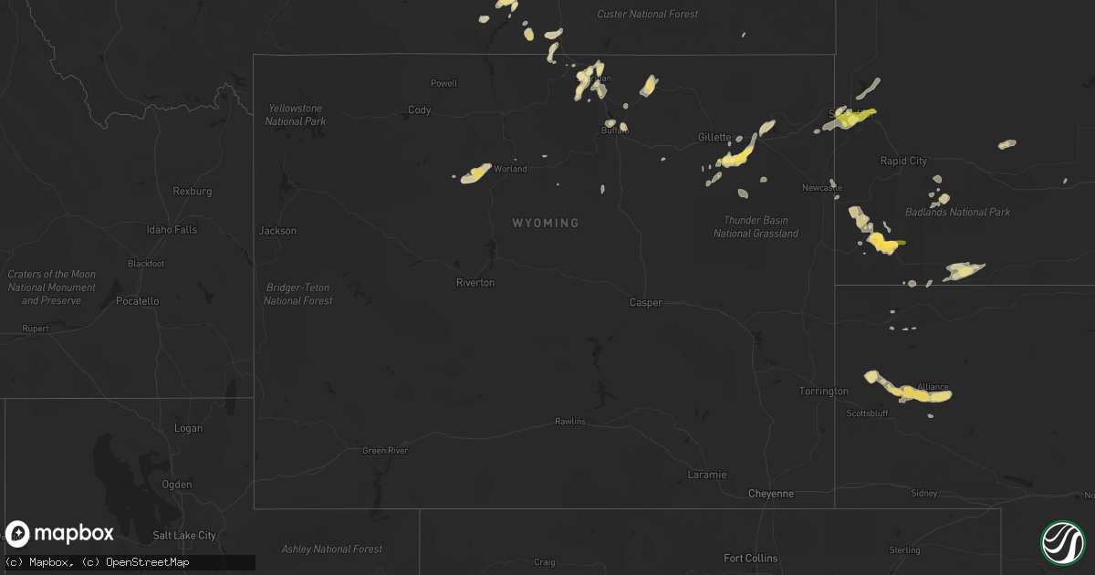
Hail Map in Wyoming on June 11, 2013
Get this storm
June 11 map
$229
one time, instant access
Download today. No call, no setup
Keep the $229
Bought the map and want the full workflow? Apply the entire $229 to a subscription within 7 days. None of it is wasted.
Every map, not just this one
This buys you this map. Subscription and you get every map we run, in the markets you choose from a few cities to whole states to nationwide. Plus real-time alerts the moment a storm fires.
Contact data
Name, contact info, occupancy, even credit band for addresses in the footprint. You go from where it hit to who to call.
Become the source they trust
Unlimited branding weather history reports on demand. You already have the documented answer ready for the property owner, and you are the one who showed up with it.
Property data and RoofTrace estimates
Pull up any address you have got, its value and the exact code rules for that jurisdiction, straight from One Click Code. Then RoofTrace estimates the squares, pitch, and roof value, priced the way you price.
Storm reports in Wyoming
Wyoming
| Date | Description |
|---|---|
| 06/11/20136:15 PM CDT | A local report indicates 80 MPH wind near 15 NE CLEARMONT |
| 06/11/20136:15 PM CDT | A local report indicates 80 MPH wind near 15 NNE CLEARMONT |
| 06/11/20136:15 PM CDT | Winds knocked down flag pole and knocked down wind break fence. Significant tree damage |
| 06/11/20136:02 PM CDT | Driving rain and small hail. |
| 06/11/20135:45 PM CDT | Mostly nickle size...some as large as quarters. No damage. |
| 06/11/20135:03 PM CDT | Individual that relayed the report to the s.o. Witnessed swirling debris including what appeared to be corregated metal |
| 06/10/20138:27 PM CDT | A local report indicates 1.25 inch wind near 13 SSE ROZET |
| 06/10/20137:30 PM CDT | Mostly penny to nickle hail...some pieces were as large as a quarter. Shredded leaves and trampled flowers. |
| 06/10/20137:28 PM CDT | A local report indicates 1.00 inch wind near 15 SE DOWNTOWN GILLETTE |
All States Impacted by Hail Map on June 11, 2013
Cities Impacted by Hail Map on June 11, 2013
- Buffalo, WY
- Ruthven, IA
- Dickens, IA
- Sorrento, FL
- Wyola, MT
- Parkman, WY
- Dayton, WY
- Casselberry, FL
- Winter Springs, FL
- Oviedo, FL
- Winter Park, FL
- Lodge Grass, MT
- Estero, FL
- Valparaiso, IN
- Irwin, IA
- Gillette, WY
- Sheridan, WY
- Chambers, NE
- Palmyra, NE
- Eagle, NE
- Everly, IA
- Spencer, IA
- Alliance, NE
- Angora, NE
- Musselshell, MT
- Roundup, MT
- Sanborn, IA
- Sheldon, IA
- Saint Xavier, MT
- Beulah, WY
- Princeton, MN
- Zimmerman, MN
- Banner, WY
- Clearmont, WY
- Mulberry, IN
- Custer, SD
- Edgemont, SD
- Hot Springs, SD
- Oral, SD
- Peterson, IA
- Sutherland, IA
- Spearfish, SD
- Frankfort, IN
- Molt, MT
- Paullina, IA
- Meriden, IA
- Cleghorn, IA
- Larrabee, IA
- Marcus, IA
- Orchard, NE
- Royal, NE
- Thermopolis, WY
- Worland, WY
- Scenic, SD
- Hermosa, SD
- Algona, IA
- Shepherd, MT
- Whitewood, SD
- Sundance, WY
- Lead, SD
- Rozet, WY
- Reed Point, MT
- Moorcroft, WY
- Yankton, SD
- Wounded Knee, SD
- Pine Ridge, SD
- Amelia, NE
- Ranchester, WY
- Niobrara, NE
- Brooksville, FL
- Floral City, FL
- Mount Dora, FL
- Apopka, FL
- Osceola, NE
- Pierson, IA
- Blunt, SD
- Inverness, FL
- Stromsburg, NE
- Polk, NE
- Broadview, MT
- Kouts, IN
- Story, WY
- Big Timber, MT
- Rapelje, MT
- Orlando, FL
- La Vernia, TX
- Seguin, TX
- Sanford, FL
- Crow Agency, MT
- New Underwood, SD
- Caputa, SD
- Eustis, FL
- Primghar, IA
- Fort Pierre, SD
- Oneill, NE
- Arvada, WY
- Royal, IA
- La Crosse, IN
- Sycamore, IL
- Maple Park, IL
- Schneider, IN
- Demotte, IN
- Lake Village, IN
- Lowell, IN
- Pierre, SD
- Whitney, NE
- Leesburg, FL
- Okahumpka, FL
- Holcomb, IL
- Stillman Valley, IL
- Clare, IL
- Rochelle, IL
- Lindenwood, IL
- Malta, IL
- Monroe Center, IL
- Esmond, IL
- Kirkland, IL
- Davis Junction, IL
- Brewster, NE
- Terril, IA
- Milford, IA
- Newcastle, WY
- Bighorn, MT
- Fort Myers, FL
- Mount Union, IA
- Utica, NE
- Ten Sleep, WY
- Ireton, IA
- West Lafayette, IN
- Harrold, SD
- Wilsall, MT
- Trimont, MN
- Hemingford, NE
- Harrison, NE
- Johns Island, SC
- Wadmalaw Island, SC
- Kingsley, IA
- Chicago, IL
- Port Orange, FL
- Warrenville, IL
- Bridgeport, NE
- Bayard, NE
- Ellsworth, NE
- Burwell, NE
- Clermont, FL
- Groveland, FL
- Newell, IA
- Palm Coast, FL
- Altoona, FL
- Kaycee, WY
- Crofton, NE
- Saint Helena, NE
- Mission Hill, SD
- Crawford, NE
- Orland Park, IL
- Adams Run, SC
- Manderson, SD
- Ryegate, MT
- Philip, SD
- Yalaha, FL
- Howey In The Hills, FL
- Oelrichs, SD
- Charleston, SC
- Belvidere, SD
- Stockdale, TX
- Tavares, FL
- Brusett, MT
- Winnett, MT
- Wilmington, IL
- Ocala, FL
- Ewing, NE
- Bolingbrook, IL
- Lame Deer, MT
- Garfield, GA
- Millen, GA
- Lincoln, NE
- Debary, FL
- Merrillville, IN
- Hobart, IN
- Hinton, IA
- Taylor, NE
- Belle Fourche, SD
- Newell, SD
- Nisland, SD
- Elburn, IL
- Wall, SD
- Hernando, FL
- Zortman, MT
- Livingston, MT
- Deland, FL
- Kennebec, SD
- Presho, SD
- Creighton, NE
- Plainview, NE
- Gary, IN
- Whiting, IN
- East Chicago, IN
- Hammond, IN
- Hartley, IA
- Truman, MN
- Estherville, IA
- Dolliver, IA
- Dekalb, IL
- Elmwood, NE
- Daytona Beach, FL
- Lennox, SD
- Garryowen, MT
- Remsen, IA
- Granville, IA
- Audubon, IA
- Vivian, SD
- Renwick, IA
- Goldfield, IA
- New Smyrna Beach, FL
- Naples, FL
- Broadus, MT
- Lake Station, IN
- Portage, IN
- Tomball, TX
- Le Mars, IA
- Vale, SD
- Mims, FL
- Wausa, NE
- Umatilla, FL
- Grand Island, FL
- Buffalo Gap, SD
- Storm Lake, IA
- Lemont, IL
- Ottosen, IA
- Upton, WY
- Summerville, SC
- Charleston Afb, SC
- Hanahan, SC
- North Charleston, SC
- Goose Creek, SC
- Ladson, SC
- Hardin, MT
- Rockford, IL
- Silver Lake, IN
- Claypool, IN
- Platte, SD
- Archer, IA
- Hospers, IA
- Union Mills, IN
- Seward, NE
- Canton, SD
- Defiance, IA
- Manilla, IA
- Chadron, NE
- Wheaton, IL
- Summit Argo, IL
- Berwyn, IL
- Westchester, IL
- Lyons, IL
- Glen Ellyn, IL
- La Grange, IL
- Winfield, IL
- Oak Brook, IL
- Riverside, IL
- Glendale Heights, IL
- Lombard, IL
- Carol Stream, IL
- La Grange Park, IL
- Western Springs, IL
- Brookfield, IL
- Hinsdale, IL
- Villa Park, IL
- Sutherland Springs, TX
- Westville, IN
- Wanatah, IN
- Elkhart, IL
- Mount Pulaski, IL
- Fruitland Park, FL
- Verdigre, NE
- Sioux City, IA
- Inman, NE
- Page, NE
- Orange City, IA
- Alton, IA
- Moville, IA
- Sioux Center, IA
- Hanna City, IL
- Montgomery, TX
- Paisley, FL
- Lavina, MT


