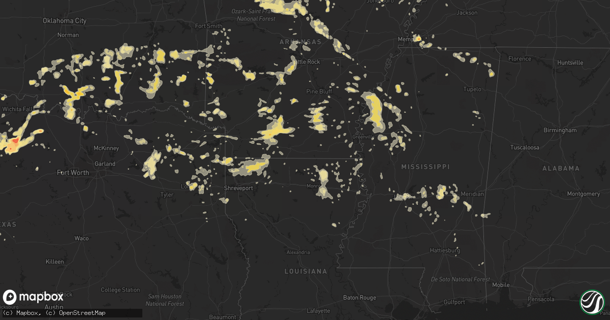
Hail Map in Texas on June 11, 2012
Get this storm
June 11 map
$229
one time, instant access
Download today. No call, no setup
Keep the $229
Bought the map and want the full workflow? Apply the entire $229 to a subscription within 7 days. None of it is wasted.
Every map, not just this one
This buys you this map. Subscription and you get every map we run, in the markets you choose from a few cities to whole states to nationwide. Plus real-time alerts the moment a storm fires.
Contact data
Name, contact info, occupancy, even credit band for addresses in the footprint. You go from where it hit to who to call.
Become the source they trust
Unlimited branding weather history reports on demand. You already have the documented answer ready for the property owner, and you are the one who showed up with it.
Property data and RoofTrace estimates
Pull up any address you have got, its value and the exact code rules for that jurisdiction, straight from One Click Code. Then RoofTrace estimates the squares, pitch, and roof value, priced the way you price.
Storm reports in Texas
Texas
| Date | Description |
|---|---|
| 06/11/20126:46 PM CDT | 6 miles west of breckenridge |
| 06/11/20126:15 AM CDT | Measured by the texas tech university mesonet |
| 06/11/20125:55 AM CDT | Measured by the texas tech university mesonet |
| 06/11/20124:00 AM CDT | Trees down in karnack. |
| 06/11/20124:00 AM CDT | Trees downed north of marshall off of fm 1793. |
| 06/11/20123:40 AM CDT | Trees downed on shady grove road. |
| 06/11/20123:40 AM CDT | Thunderstorm wind gusts peeled back the roof of an apartment complex off of main street. |
| 06/11/20123:35 AM CDT | Numerous trees down in the liberty-eylau community including one that fell on a home on macedonia street. A tree fell on a barn off of county road 2516 at the end of ry |
| 06/11/20123:30 AM CDT | Trees were downed. |
| 06/11/20123:25 AM CDT | The top of a tree was snapped off and landed across a house. |
| 06/11/20123:20 AM CDT | Trees were downed. |
| 06/11/20123:15 AM CDT | Several trees downed around town including one that fell on top of a home on n. Bowie rd. |
| 06/11/20122:57 AM CDT | Numerous trees downed across the county |
| 06/11/20122:52 AM CDT | Tree downed on fm 2869 |
| 06/11/20122:46 AM CDT | Tree on house on highway 271 north of co rd 1435. |
| 06/11/20122:45 AM CDT | Numerous trees downed across the county |
| 06/11/20122:43 AM CDT | Powerline downed on cr 3230 |
| 06/11/20122:23 AM CDT | Tree downed on county road 4878 |
| 06/11/20122:20 AM CDT | 60 mph winds south of como on fm69. Several trees down on fm69 |
| 06/11/20122:15 AM CDT | Hail covered the ground east of redwater. |
| 06/11/20121:55 AM CDT | Trees down in paris. Paris awos reported 45 mph gusts. |
| 06/11/20121:50 AM CDT | Numerous trees blown down by estimated 65 mph winds near fm71 and fm69 |
| 06/11/20121:46 AM CDT | Small trees were knocked down across the county |
| 06/11/20121:44 AM CDT | Deputy estimated 60 mph in cooper |
| 06/11/201212:55 AM CDT | Roof blown off a mobile home in ravenna and large trees down throughout the county |
| 06/11/201212:47 AM CDT | Between wolfe city and bailey on highway 11 |
| 06/10/201211:56 PM CDT | Top of a living tree fell into a west facing window of a residence. Detached portion of tree was 10 inches in diameter. Most likely from winds. |
| 06/10/201211:15 PM CDT | 60 mph wind gusts between gainesville and lake kiowa |
| 06/10/201210:26 PM CDT | A local report indicates 1.00 inch wind near HENRIETTA |
| 06/10/20129:27 PM CDT | Nr county line |
| 06/10/20129:19 PM CDT | Ping pong ball sized hail was reported 5 miles ene of vashti |
| 06/10/20129:03 PM CDT | Hen egg sized hail was reported 5 miles ene of padgitt via spotter network |
| 06/10/20128:54 PM CDT | 2 power poles blown over along us380 |
| 06/10/20128:43 PM CDT | Quarter sized hail was reported 6 miles south of olney |
| 06/10/20128:43 PM CDT | 60 mph winds were estimated 6 miles south of olney |
| 06/10/20128:40 PM CDT | Quarter sized hail in jermyn |
| 06/10/20128:32 PM CDT | Lots of golf ball sized hail was reported 2 miles south of loving. |
| 06/10/20128:20 PM CDT | Lasted for 10 minutes |
| 06/10/20128:15 PM CDT | Egg sized hail was reported in graham. This report was relayed via broadcast media. |
| 06/10/20128:13 PM CDT | Baseball sized hail was reported near the jean area. |
| 06/10/20128:05 PM CDT | Trees and power lines blown down...and roofs damaged on a couple of structures in brownwood. Several streets were blocked off due to flooding. |
| 06/10/20128:00 PM CDT | Downburst winds caused significant damage in newcastle. Power lines and poles are down. Light roof damage reported so far. 15'x15' outbuildings blown against houses. On |
| 06/10/20127:55 PM CDT | Tennis ball to baseball sized hail was reported near fort belknap state park |
| 06/10/20127:35 PM CDT | 60 mph winds at dyess afb |
| 06/10/20127:35 PM CDT | 60 mph winds at dyess afb |
| 06/10/20127:26 PM CDT | Tennis ball sized hail was reported 3 miles south of eliasville |
| 06/10/20127:26 PM CDT | 60 mph winds at dyess afb |
| 06/10/20127:12 PM CDT | Quarter hail at the cvs drug store on west walker street in breckenridge |
| 06/10/20127:00 PM CDT | Half dollar sized hail was reported on the peninsula on the eastern side of hubbard creek lake |
All States Impacted by Hail Map on June 11, 2012
Cities Impacted by Hail Map on June 11, 2012
- Bucyrus, MO
- Huggins, MO
- Graff, MO
- Mountain Grove, MO
- Plato, MO
- Santa Rosa, NM
- Grove Hill, AL
- Brinkley, AR
- Biscoe, AR
- Sulphur Springs, TX
- Niangua, MO
- Heber Springs, AR
- Seymour, TX
- Poulan, GA
- Timpson, TX
- Marshall, AR
- Pittsburg, OK
- Kiowa, OK
- Itta Bena, MS
- Sidon, MS
- Tchula, MS
- Lexington, MS
- Moorhead, MS
- Belzoni, MS
- Cruger, MS
- Hampton, AR
- Sicily Island, LA
- Shell Knob, MO
- Raymond, MS
- Hartville, MO
- San Jon, NM
- Bard, NM
- Hereford, TX
- Broadview, NM
- Townsend, GA
- Tunas, MO
- Garden City, TX
- Sainte Genevieve, MO
- Beecher City, IL
- Wynnewood, OK
- Quitman, MS
- Booneville, MS
- Tishomingo, MS
- Collierville, TN
- Olive Branch, MS
- Memphis, TN
- Rossville, TN
- Byhalia, MS
- Talco, TX
- Monroe, LA
- Collinston, LA
- Bastrop, LA
- Mountain View, AR
- Millersview, TX
- Eden, TX
- Menard, TX
- Cabool, MO
- Louann, AR
- Stonewall, MS
- Enterprise, MS
- Timbo, AR
- Onia, AR
- Exeter, MO
- Cassville, MO
- Big Lake, TX
- Seligman, MO
- Washburn, MO
- Fairview, MO
- Wheaton, MO
- Rocky Comfort, MO
- Butterfield, MO
- Eagle Rock, MO
- Purdy, MO
- Saint Augustine, FL
- East Palatka, FL
- Green Cove Springs, FL
- Elkton, FL
- Palatka, FL
- Sterling City, TX
- Farmington, MO
- Floyd, NM
- Conchas Dam, NM
- Pittsburg, TX
- Elkland, MO
- Grady, AR
- Pine Bluff, AR
- Hatfield, AR
- Cove, AR
- Vandervoort, AR
- Hodgen, OK
- Bivins, TX
- Rodessa, LA
- Bunnell, FL
- Brunswick, GA
- Hortense, GA
- Shelby, MS
- Mound Bayou, MS
- Sylacauga, AL
- Wilsonville, AL
- Shelby, AL
- Columbiana, AL
- Jacksonville, FL
- Mcalester, OK
- Stuart, OK
- Calvin, OK
- Hastings, FL
- Springfield, AR
- Center Ridge, AR
- Solgohachia, AR
- Flowood, MS
- Throckmorton, TX
- Bethel, OK
- Broken Bow, OK
- Rattan, OK
- Sapelo Island, GA
- Nevada, MO
- Seymour, MO
- Marshfield, MO
- Jerico Springs, MO
- Big Spring, TX
- Happy, TX
- Hot Springs National Park, AR
- Kimberling City, MO
- Reeds Spring, MO
- Haworth, OK
- Foreman, AR
- Minter City, MS
- Charleston, MS
- Dora, MO
- Aurora, MO
- Newcastle, TX
- Olney, TX
- Coalgate, OK
- Coleman, OK
- Atoka, OK
- Centrahoma, OK
- Tupelo, OK
- Caddo, OK
- Wapanucka, OK
- Kenefic, OK
- Walnut, MS
- Tiplersville, MS
- Corinth, MS
- Commerce, TX
- Yellville, AR
- Everton, AR
- Valley Springs, AR
- Harrison, AR
- Leslie, AR
- Lead Hill, AR
- Pyatt, AR
- Blue Eye, MO
- Green Forest, AR
- Pindall, AR
- Gilbert, AR
- Saint Joe, AR
- Hollister, MO
- Omaha, AR
- Ridgedale, MO
- Alpena, AR
- Oak Grove, AR
- Duncan, OK
- Marlow, OK
- Melrose, NM
- Mansfield, MO
- Ava, MO
- Macomb, MO
- Bigelow, AR
- Vanzant, MO
- Drury, MO
- Norwood, MO
- Muenster, TX
- Burneyville, OK
- Leon, OK
- Lockwood, MO
- Greenfield, MO
- Yulee, FL
- Callahan, FL
- Morton, MS
- Raleigh, MS
- Bellevue, TX
- Bowie, TX
- Lake Village, AR
- Portland, AR
- Henrietta, TX
- Ovett, MS
- Dexter, MO
- Imboden, AR
- Westbrook, TX
- Aspermont, TX
- Benton, KY
- Hardin, KY
- Midway, GA
- Hinesville, GA
- Riceboro, GA
- Mount Pleasant, TX
- Yantis, TX
- Hallsville, TX
- White Oak, TX
- Gilmer, TX
- Kilgore, TX
- Longview, TX
- Gladewater, TX
- Marathon, TX
- Dryden, TX
- Grand Saline, TX
- Mineola, TX
- Vivian, LA
- Ida, LA
- Moultrie, GA
- Pierce City, MO
- Star City, AR
- Fordland, MO
- Rogersville, MO
- Jonesboro, AR
- Norman, AR
- Tucumcari, NM
- Waterloo, IL
- Red Bud, IL
- Fults, IL
- Walnut Grove, MO
- Delhi, LA
- Moyers, OK
- Boswell, OK
- Soper, OK
- Finley, OK
- Antlers, OK
- Snow, OK
- Clayton, OK
- Hugo, OK
- Gurdon, AR
- Clinton, AR
- Scotland, AR
- Eminence, MO
- Carthage, AR
- Stratford, OK
- Mount Judea, AR
- Vendor, AR
- Parthenon, AR
- Deer, AR
- Searcy, AR
- Texarkana, TX
- Hooks, TX
- Ridgely, TN
- Bay, AR
- Ocala, FL
- Carthage, MO
- Reeds, MO
- Camden, AR
- Stonewall, OK
- Ada, OK
- Fitzhugh, OK
- Allen, OK
- Pittsburg, KS
- Hartshorne, OK
- Blanco, OK
- Batesville, AR
- Booneville, AR
- Germantown, TN
- Cordova, TN
- Richmond Hill, GA
- Holdenville, OK
- Darien, GA
- Stockton, MO
- Leland, MS
- Hermitage, AR
- Wilmar, AR
- Warren, AR
- Horatio, AR
- Keatchie, LA
- Keithville, LA
- Mena, AR
- Denison, TX
- Cartwright, OK
- Harleton, TX
- Tutwiler, MS
- Bradleyville, MO
- Taneyville, MO
- Zalma, MO
- Sturdivant, MO
- Marble Hill, MO
- Oran, MO
- Advance, MO
- Melvin, AL
- Loving, TX
- Graham, TX
- Deerfield, MO
- Bronaugh, MO
- Fort Scott, KS
- Baird, TX
- Fair Grove, MO
- Half Way, MO
- Buffalo, MO
- Winona, MS
- Silverton, TX
- Sturgis, KY
- Healdton, OK
- Dermott, AR
- Tillar, AR
- Monticello, AR
- Heavener, OK
- Watson, AR
- Marks, MS
- Lambert, MS
- Monett, MO
- Stark City, MO
- Sasakwa, OK
- Prescott, AR
- Red Oak, OK
- Wister, OK
- Alba, TX
- Winfield, TX
- Ardmore, OK
- Harpersville, AL
- Childersburg, AL
- Sterrett, AL
- Golden City, MO
- Drew, MS
- Parchman, MS
- Des Arc, AR
- Tioga, TX
- Jermyn, TX
- Fort Smith, AR
- Greenwood, AR
- Vincent, AL
- Hazlehurst, GA
- Sparks, GA
- Adel, GA
- Griffithville, AR
- Enid, MS
- Batesville, MS
- Benton, AR
- Brownwood, TX
- Springfield, MO
- Holliday, TX
- Everton, MO
- Essex, MO
- Sikeston, MO
- Fouke, AR
- Texarkana, AR
- Mendenhall, MS
- Durant, OK
- Kingston, OK
- Madill, OK
- Mead, OK
- Calera, OK
- Colorado City, TX
- Thomasville, GA
- Wardville, OK
- Squires, MO
- Ash Grove, MO
- Dyersburg, TN
- Lenox, TN
- Stephens, AR
- De Witt, AR
- Woodson, TX
- Maysville, OK
- Pauls Valley, OK
- Paoli, OK
- Stella, MO
- Huntsville, AR
- Berryville, AR
- Shaw, MS
- Clarksville, TX
- Rincon, GA
- Springfield, GA
- Rienzi, MS
- Sarepta, LA
- Benton, LA
- Cotton Valley, LA
- Linden, TX
- Winthrop, AR
- Bardwell, KY
- Theodosia, MO
- Barlow, KY
- Gainesville, TX
- Tiptonville, TN
- Union City, TN
- Comanche, OK
- Patton, MO
- Glenallen, MO
- Leopold, MO
- Inverness, MS
- Indianola, MS
- Lucedale, MS
- Leakesville, MS
- Arkadelphia, AR
- Sparkman, AR
- Idabel, OK
- Moundville, MO
- Wilburton, OK
- Mindenmines, MO
- Mulberry, KS
- Robert Lee, TX
- Walters, OK
- Temple, OK
- Saint Jo, TX
- Lone Grove, OK
- Loco, OK
- Overbrook, OK
- Springer, OK
- Wilson, OK
- Mount Holly, AR
- Magnolia, AR
- Chidester, AR
- Rosston, AR
- Waldo, AR
- McNeil, AR
- Moran, TX
- Stamps, AR
- Buckner, AR
- Hot Springs Village, AR
- Lonsdale, AR
- Lake Creek, TX
- Holcomb, MO
- Electra, TX
- Mineral Wells, TX
- Locust Grove, AR
- Drasco, AR
- Concord, AR
- Pleasant Grove, AR
- Clinton, KY
- Bolivar, MO
- Long Lane, MO
- Oldfield, MO
- Pleasant Hope, MO
- Conway, MO
- Strafford, MO
- Bonnerdale, AR
- Story, AR
- Mount Ida, AR
- Phillipsburg, MO
- Lebanon, MO
- Blytheville, AR
- Duncan, MS
- Snow Lake, AR
- Gunnison, MS
- Crumrod, AR
- Boyle, MS
- Merigold, MS
- Cleveland, MS
- Alligator, MS
- Clarksdale, MS
- De Berry, TX
- Marshall, TX
- Waldron, AR
- Queen City, TX
- El Dorado Springs, MO
- Sheldon, MO
- Prairie Du Rocher, IL
- Parma, MO
- Bell City, MO
- Russellville, AL
- Red Bay, AL
- Talihina, OK
- Howe, OK
- Tallahassee, FL
- Crossett, AR
- Hamburg, AR
- Tuskahoma, OK
- Oden, AR
- Sims, AR
- Parks, AR
- Pencil Bluff, AR
- Fernandina Beach, FL
- Friona, TX
- Arlington, KY
- Greenway, AR
- Piggott, AR
- Senath, MO
- Kennett, MO
- Rector, AR
- Jacksboro, TX
- Oak Grove, LA
- Hornersville, MO
- Tulia, TX
- Garita, NM
- Aberdeen, MS
- Conway, AR
- Citronelle, AL
- Ripley, MS
- Ashland, MS
- Falkner, MS
- Charleston, MO
- Evansville, IL
- Hughes Springs, TX
- Eudora, AR
- Willard, MO
- Clyde, TX
- Ovalo, TX
- Hector, AR
- Hagarville, AR
- Pelsor, AR
- Witts Springs, AR
- Miles, TX
- Loraine, TX
- State University, AR
- Lenox, GA
- McRae, AR
- Norman Park, GA
- Protem, MO
- Atwood, OK
- Tatum, TX
- Jackson, AL
- Windthorst, TX
- Newkirk, NM
- Sharon, TN
- Rives, TN
- Curtis, MI
- Engadine, MI
- Little Rock, MS
- Union, MS
- Decatur, MS
- Elmore City, OK
- Stringer, MS
- Pomona, MO
- Manila, AR
- Belcher, LA
- Oil City, LA
- Terrell, TX
- Cape Girardeau, MO
- Davis, OK
- Wayne, OK
- Byars, OK
- Hennepin, OK
- Thornfield, MO
- Isabella, MO
- Houston, AR
- Mayflower, AR
- Roland, AR
- Greenville, TX
- Homer, LA
- Minden, LA
- Boston, GA
- Pavo, GA
- Shirley, AR
- Rose Bud, AR
- Quitman, AR
- House, NM
- Mcalister, NM
- Ponce De Leon, MO
- Galena, MO
- Crane, MO
- Spokane, MO
- Highlandville, MO
- Breckenridge, TX
- Brandon, MS
- Atlanta, TX
- Coleman, TX
- Cairo, IL
- Malvern, AR
- Alexander, AR
- Bryant, AR
- Paron, AR
- Donaldson, AR
- Little Rock, AR
- Lockesburg, AR
- Wilton, AR
- Mount Vernon, TX
- Cuervo, NM
- Leary, GA
- Arlington, GA
- Lake Providence, LA
- Royal, AR
- Oronogo, MO
- Webb City, MO
- Humphrey, AR
- Wabbaseka, AR
- Hopkinsville, KY
- Pembroke, KY
- Trenton, TN
- Jasper, AR
- Marble Falls, AR
- Tilly, AR
- Jerusalem, AR
- Nocona, TX
- Ringgold, TX
- Burkett, TX
- Belmont, MS
- Dennis, MS
- Charleston, AR
- Snyder, TX
- Post, TX
- Justiceburg, TX
- Tallulah, LA
- Sherwood, AR
- Vilonia, AR
- Jacksonville, AR
- Early, TX
- Newton, MS
- Lake, MS
- Lawrence, MS
- Rich Hill, MO
- Lamont, FL
- Bruner, MO
- Sparta, MO
- Diana, TX
- Big Sandy, TX
- Emory, TX
- Fort Stewart, GA
- Stuttgart, AR
- Casscoe, AR
- Roe, AR
- Hickory, MS
- Melbourne, AR
- Gainesville, MO
- Saint Simons Island, GA
- Caddo Gap, AR
- Osceola, AR
- Stamford, TX
- Emerson, AR
- Vicksburg, MS
- Romance, AR
- Haileyville, OK
- Dixie, GA
- Jasper, MO
- Miller, MO
- South Greenfield, MO
- La Russell, MO
- Success, MO
- Fox, AR
- Tishomingo, OK
- Milburn, OK
- Avinger, TX
- Compton, AR
- Branson, MO
- Walnut Shade, MO
- Billings, MO
- Republic, MO
- Marionville, MO
- Mount Vernon, MO
- Asbury, MO
- Eureka Springs, AR
- Haughton, LA
- Shreveport, LA
- Plain Dealing, LA
- Springhill, LA
- Mooringsport, LA
- Haynesville, LA
- Gilliam, LA
- Shongaloo, LA
- Jefferson, TX
- Sterlington, LA
- Daingerfield, TX
- Isola, MS
- Naylor, GA
- Lakeland, GA
- Hazen, AR
- Simsboro, LA
- Hermitage, MO
- Fruitvale, TX
- Doddridge, AR
- Bernice, LA
- Windyville, MO
- Greenbrier, AR
- Crocketts Bluff, AR
- Walnut Grove, MS
- Forest, MS
- Conehatta, MS
- Arma, KS
- Franklin, KS
- Rush Springs, OK
- Lindsay, OK
- Marquand, MO
- West Plains, MO
- Lynchburg, MO
- Mer Rouge, LA
- Epps, LA
- Rayville, LA
- Pioneer, LA
- Monticello, FL
- Ozark, MO
- Nixa, MO
- Transylvania, LA
- Rison, AR
- Rochelle, TX
- Rockwood, TX
- Willow Springs, MO
- Hornbeak, TN
- Sunflower, MS
- Rosedale, MS
- Doddsville, MS
- Mellwood, AR
- Benoit, MS
- Beulah, MS
- Ruston, LA
- Springfield, TN
- Williamsville, MO
- Wappapello, MO
- Hendrix, OK
- Samson, AL
- England, AR
- Hollandale, MS
- Stringtown, OK
- Pearl, MS
- Jackson, MS
- Bryson, TX
- Karnack, TX
- El Dorado, AR
- Junction City, AR
- Chunchula, AL
- Axis, AL
- Taylorsville, MS
- Mangham, LA
- Avery, TX
- Ryan, OK
- Houston, AL
- Mullin, TX
- Bolton, MS
- Clinton, MS
- Farmerville, LA
- Ringling, OK
- Mill Creek, OK
- Sulphur, OK
- Athens, LA
- Forsyth, MO
- Chadwick, MO
- Garrison, MO
- Moscow, TN
- Lamar, MS
- Clarendon, AR
- Konawa, OK
- Roff, OK
- Eads, TN
- Coila, MS
- Adrian, TX
- Foster, OK
- Rueter, MO
- Dadeville, MO
- Pickton, TX
- Quitman, TX
- Como, TX
- Winnsboro, TX
- Deer Park, AL
- Bear Creek, AL
- Friendship, TN
- Goldsboro, TX
- Lawn, TX
- New Edinburg, AR
- Okolona, AR
- Harwood, MO
- Walker, MO
- Hume, MO
- Atmore, AL
- Schell City, MO
- Clever, MO
- Bono, AR
- Mayersville, MS
- Higden, AR
- De Queen, AR
- Mize, MS
- Lithia, FL
- Garnett, SC
- Clyo, GA
- Potts Camp, MS
- Myrtle, MS
- Richland, MS
- Ponca, AR
- Ruleville, MS
- Schlater, MS
- Poolville, TX
- Beebe, AR
- Salem, MO
- Ellington, MO
- Winona, MO
- Greenville, MS
- Bertrand, MO
- Dennard, AR
- Point, TX
- Fairfield Bay, AR
- Daisy, OK
- Pelahatchie, MS
- Bois D Arc, MO
- Bonita, LA
- Falcon, MO
- McIntosh, AL
- Klondike, TX
- Damascus, GA
- Jacksonville Beach, FL
- Ponte Vedra, FL
- Saint Johns, FL
- Ponte Vedra Beach, FL
- Saltillo, TX
- Gibsland, LA
- Clovis, NM
- Collinsville, TX
- Valley View, TX
- West Point, MS
- Jefferson, AR
- Lowry City, MO
- Osceola, MO
- Appleton City, MO
- Hosston, LA
- Bogata, TX
- Deport, TX
- Cotton Plant, AR
- Luxora, AR
- Quinton, OK
- Florence, MS
- Verona, MO
- Smithville, OK
- Honobia, OK
- Graford, TX
- Strawn, TX
- Watson, OK
- Naples, TX
- Marietta, TX
- Simms, TX
- Martin, TN
- Golden, MS
- New Site, MS
- Winters, TX
- Cumby, TX
- Pecan Gap, TX
- Wolfe City, TX
- Cooper, TX
- Ladonia, TX
- De Kalb, TX
- Lenzburg, IL
- Greenwood, MS
- Greenville, MO
- Glenwood, AR
- Wagarville, AL
- Tibbie, AL
- Big Flat, AR
- Perryville, AR
- Bay Minette, AL
- Kirbyville, MO
- Pelican, LA
- Rockville, MO
- Crenshaw, MS
- Sledge, MS
- Wheatland, MO
- McClure, IL
- Dexter, KY
- Murray, KY
- Winnsboro, LA
- Diamond, MO
- Brownsville, TN
- Valliant, OK
- Lindsay, TX
- Sedgewickville, MO
- Lena, MS
- Glendora, MS
- Philipp, MS
- Canyon, TX
- Newbern, TN
- Uriah, AL
- Oakland, TN
- Thomasville, AL
- Guyton, GA
- Courtland, MS
- Pope, MS
- Higginson, AR
- Waynesville, GA
- Jesup, GA
- Beckville, TX
- Statesboro, GA
- Mansfield, AR
- Hartford, AR
- Shubuta, MS
- Harrisburg, AR
- Weiner, AR
- New Boston, TX
- Braxton, MS
- Bee Branch, AR
- Yukon, MO
- Aldrich, MO
- Omega, GA
- Hawthorne, FL
- Creal Springs, IL
- McGehee, AR
- Grovespring, MO
- Bloomfield, MO
- Amarillo, TX
- Hasty, AR
- Western Grove, AR
- Wentworth, MO
- Golden, MO
- Granby, MO
- Rose Hill, MS
- Brookport, IL
- Paducah, KY
- Gilbertsville, KY
- Clayton, LA
- Berlin, GA
- Barney, GA
- Hahira, GA
- Cedarcreek, MO
- Mount Pleasant, MI
- Houston, MO
- Elk Creek, MO
- Ravenna, TX
- Bonham, TX
- Ivanhoe, TX
- Bridgeport, TX
- Boles, AR
- Gary, TX
- Long Branch, TX
- Troy, TN
- Brewton, AL
- Obion, TN
- Alpine, AL
- Kissee Mills, MO
- Satartia, MS
- Holly Grove, AR
- Aubrey, AR
- Vina, AL
- Fredericktown, MO
- Fittstown, OK
- Oak Ridge, LA
- Urbana, MO
- Clarksville, TN
- Eastman, GA
- Ore City, TX
- Baskin, LA
- Marion, LA
- Mannsville, OK
- Albany, TX
- Walnut Ridge, AR
- Alicia, AR
- Goreville, IL
- Liberal, MO
- Lamar, MO
- Leeds, AL
- Chelsea, AL
- Birmingham, AL
- Montrose, AR
- Windom, TX
- Portageville, MO
- Aledo, TX
- Branch, AR
- Peel, AR
- Louin, MS
- Chunky, MS
- Perryville, MO
- Chester, IL
- Brashear, TX
- Edgewood, TX
- Leachville, AR
- Midland, TX
- Banks, AR
- Gillett, AR
- Magee, MS
- Black Rock, AR
- Carterville, MO
- Joplin, MO
- Paradise, TX
- Ashdown, AR
- Chestnutridge, MO
- Coahoma, TX
- Grannis, AR
- Wickes, AR
- Wynne, AR
- Michigan City, MS
- Scroggins, TX
- Leesburg, TX
- Cascilla, MS
- Altheimer, AR
- Richton, MS
- New Augusta, MS
- Laurel, MS
- Gillham, AR
- Desha, AR
- Little River, AL
- Ethel, AR
- Norfork, AR
- Leonard, TX
- Celeste, TX
- Bluff City, AR
- Gilbertown, AL
- Needham, AL
- Butler, AL
- Mount Vernon, AR
- Pangburn, AR
- West Monroe, LA
- Almyra, AR
- Arcola, MO
- Halltown, MO
- Sarcoxie, MO
- Brookline, MO
- Nashville, GA
- Cape Fair, MO
- Marvell, AR
- Maumelle, AR
- Wilson, AR
- Smithville, AR
- Rhine, GA
- Palm Coast, FL
- Butler, MO
- Pilot Point, TX
- Gunter, TX


