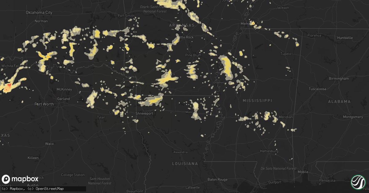
Hail Map in Tennessee on June 11, 2012
Get this storm
June 11 map
$229
one time, instant access
Download today. No call, no setup
Keep the $229
Bought the map and want the full workflow? Apply the entire $229 to a subscription within 7 days. None of it is wasted.
Every map, not just this one
This buys you this map. Subscription and you get every map we run, in the markets you choose from a few cities to whole states to nationwide. Plus real-time alerts the moment a storm fires.
Contact data
Name, contact info, occupancy, even credit band for addresses in the footprint. You go from where it hit to who to call.
Become the source they trust
Unlimited branding weather history reports on demand. You already have the documented answer ready for the property owner, and you are the one who showed up with it.
Property data and RoofTrace estimates
Pull up any address you have got, its value and the exact code rules for that jurisdiction, straight from One Click Code. Then RoofTrace estimates the squares, pitch, and roof value, priced the way you price.
Storm reports in Tennessee
Tennessee
| Date | Description |
|---|---|
| 06/11/20126:40 PM CDT | A tree was reported downed in the white house area. |
| 06/11/20125:19 PM CDT | Trees and power lines were downed at evans and britton springs road in the northwestern portion of the city of clarksville. Power lines were also downed along madison s |
| 06/11/20125:16 PM CDT | Wind gust of 59 mph measured at the intersection of highway 412 west and garrison road one mile east of the perry county line. |
| 06/11/20125:05 PM CDT | A few trees were downed across the county...some falling into power lines and temporarily causing power outages. Also the steeple was knocked off of a baptist church in |
| 06/11/20124:55 PM CDT | A tree was blown down on highway 13 north |
| 06/11/20124:55 PM CDT | Vinyl siding ripped off house... Damamged shingles... Nixon area |
| 06/11/20124:50 PM CDT | Two trees were blown down |
| 06/11/20124:49 PM CDT | Large tree down in fox meadows golf course near clark rd |
| 06/11/20124:45 PM CDT | Power line and trees knocked down |
| 06/11/20124:38 PM CDT | A storm spotter has reported a tree down along farm road on shelby farms in east memphis with another tree down along shady grove road near south of walnut grove road. |
| 06/11/20124:36 PM CDT | A tree was downed in the land between the lakes region. |
| 06/11/20124:35 PM CDT | Trees down across the county. Trees down on bohanis landing road...blount road...hwwy 114 to name a few. |
| 06/11/20124:30 PM CDT | Several trees were reported downed on sandy river road and industrial road. |
| 06/11/20124:20 PM CDT | Trees snapped or uprooted on north parkway |
| 06/11/20124:00 PM CDT | Very large oak tree down on house. Moderate damage to two neighboring homes. Half mile south of the memphis botanical gardens. |
| 06/11/20123:55 PM CDT | Trees down in jackson |
| 06/11/20123:55 PM CDT | Trees down in fox ridge subdivision |
| 06/11/20123:50 PM CDT | Powerlines down on poplar and miller farms. |
| 06/11/20123:49 PM CDT | Large tree down in fox meadows golf course near clark rd |
| 06/11/20123:48 PM CDT | A storm spotter has reported a tree down along farm road on shelby farms in east memphis with another tree down along shady grove road near south of walnut grove road. |
| 06/11/20123:46 PM CDT | Golf ball sized hail reported 4 miles west of cordova. Relayed by mspotter. At the intersection of macon and dexter. |
| 06/11/20123:46 PM CDT | Golf ball sized hail reported 4 miles west of cordova. Relayed by mspotter. At the intersection of macon and dexter. |
| 06/11/20123:45 PM CDT | 58 mph gust measured at jackson mckeller airport. |
| 06/11/20123:40 PM CDT | Trees snapped or uprooted on north parkway |
| 06/11/20123:40 PM CDT | Large tree down...power is also out in gibson. Very windy in milan also. |
| 06/11/20123:40 PM CDT | Traffic signal knocked down at the intersection of danny thomas and washington |
| 06/11/20123:40 PM CDT | Nickel to quarter sized hail at 1260 whitten road. |
| 06/11/20123:40 PM CDT | Penny to quarter size hail reported near walnut grove rd |
| 06/11/20123:40 PM CDT | Dugout roof of the bartlett baptist church ballfield blown about 40 feet. |
| 06/11/20123:35 PM CDT | Additional trees snapped between gibson and milan. |
| 06/11/20123:35 PM CDT | Large tree down on memphis-arlington road just west of arlington middle school. Relayed by mspotter. |
| 06/11/20123:35 PM CDT | Powerlines down and a tree blown onto a house in the atwood community. |
| 06/11/20123:30 PM CDT | Trees down near rivercrest elementary school. Report relayed by mspotter. |
| 06/11/20123:30 PM CDT | Scattered trees down across gibson county. A few on hwy 104. |
| 06/11/20123:30 PM CDT | Roof damage |
| 06/11/20123:29 PM CDT | Tree down on north parkway eastbound behind east parkway and university. Report relayed by mspotter. |
| 06/11/20123:25 PM CDT | Trees snapped...large limbs down on hwy 45 2 miles outside of bradford. |
| 06/11/20123:15 PM CDT | Wind damage on adams road. Roof damage to a building and a large wooden outbuilding completely collapsed. Also major roof damage to a manufactured home. |
| 06/11/20123:11 PM CDT | Powerlines down near the covington fire department...tree on a house in covington. Trees down on train tracks behind the tipton county sheriff office. Reports relayed b |
| 06/11/20123:11 PM CDT | Wind gust of 65 mph estimated by storm spotter. Relayed by mspotter |
| 06/11/20123:06 PM CDT | Large tree blown down...blocking knox daniel road in obion. |
| 06/11/20123:06 PM CDT | Estimated wind gust by spotter in ripley. Relayed by mspotter. |
| 06/11/20122:55 PM CDT | Truck blown off hwy 45. Telephone poles snapped. Report of 60 mph wind gust |
| 06/11/20122:54 PM CDT | Large tree limbs down...1 tree uprooted on the north side of union city. Winds estimated at greater than 60 mph. |
| 06/11/20122:45 PM CDT | Large tree down and blocking meacham road. Trampoline blown into the road. |
| 06/11/20122:30 PM CDT | Roof damage |
| 06/11/20122:30 PM CDT | Trees down at reelfoot lake. |
| 06/10/20127:00 PM CDT | Trees down and shed damaged. |
All States Impacted by Hail Map on June 11, 2012
Cities Impacted by Hail Map on June 11, 2012
- Bucyrus, MO
- Huggins, MO
- Graff, MO
- Mountain Grove, MO
- Plato, MO
- Santa Rosa, NM
- Grove Hill, AL
- Brinkley, AR
- Biscoe, AR
- Sulphur Springs, TX
- Niangua, MO
- Heber Springs, AR
- Seymour, TX
- Poulan, GA
- Timpson, TX
- Marshall, AR
- Pittsburg, OK
- Kiowa, OK
- Itta Bena, MS
- Sidon, MS
- Tchula, MS
- Lexington, MS
- Moorhead, MS
- Belzoni, MS
- Cruger, MS
- Hampton, AR
- Sicily Island, LA
- Shell Knob, MO
- Raymond, MS
- Hartville, MO
- San Jon, NM
- Bard, NM
- Hereford, TX
- Broadview, NM
- Townsend, GA
- Tunas, MO
- Garden City, TX
- Sainte Genevieve, MO
- Beecher City, IL
- Wynnewood, OK
- Quitman, MS
- Booneville, MS
- Tishomingo, MS
- Collierville, TN
- Olive Branch, MS
- Memphis, TN
- Rossville, TN
- Byhalia, MS
- Talco, TX
- Monroe, LA
- Collinston, LA
- Bastrop, LA
- Mountain View, AR
- Millersview, TX
- Eden, TX
- Menard, TX
- Cabool, MO
- Louann, AR
- Stonewall, MS
- Enterprise, MS
- Timbo, AR
- Onia, AR
- Exeter, MO
- Cassville, MO
- Big Lake, TX
- Seligman, MO
- Washburn, MO
- Fairview, MO
- Wheaton, MO
- Rocky Comfort, MO
- Butterfield, MO
- Eagle Rock, MO
- Purdy, MO
- Saint Augustine, FL
- East Palatka, FL
- Green Cove Springs, FL
- Elkton, FL
- Palatka, FL
- Sterling City, TX
- Farmington, MO
- Floyd, NM
- Conchas Dam, NM
- Pittsburg, TX
- Elkland, MO
- Grady, AR
- Pine Bluff, AR
- Hatfield, AR
- Cove, AR
- Vandervoort, AR
- Hodgen, OK
- Bivins, TX
- Rodessa, LA
- Bunnell, FL
- Brunswick, GA
- Hortense, GA
- Shelby, MS
- Mound Bayou, MS
- Sylacauga, AL
- Wilsonville, AL
- Shelby, AL
- Columbiana, AL
- Jacksonville, FL
- Mcalester, OK
- Stuart, OK
- Calvin, OK
- Hastings, FL
- Springfield, AR
- Center Ridge, AR
- Solgohachia, AR
- Flowood, MS
- Throckmorton, TX
- Bethel, OK
- Broken Bow, OK
- Rattan, OK
- Sapelo Island, GA
- Nevada, MO
- Seymour, MO
- Marshfield, MO
- Jerico Springs, MO
- Big Spring, TX
- Happy, TX
- Hot Springs National Park, AR
- Kimberling City, MO
- Reeds Spring, MO
- Haworth, OK
- Foreman, AR
- Minter City, MS
- Charleston, MS
- Dora, MO
- Aurora, MO
- Newcastle, TX
- Olney, TX
- Coalgate, OK
- Coleman, OK
- Atoka, OK
- Centrahoma, OK
- Tupelo, OK
- Caddo, OK
- Wapanucka, OK
- Kenefic, OK
- Walnut, MS
- Tiplersville, MS
- Corinth, MS
- Commerce, TX
- Yellville, AR
- Everton, AR
- Valley Springs, AR
- Harrison, AR
- Leslie, AR
- Lead Hill, AR
- Pyatt, AR
- Blue Eye, MO
- Green Forest, AR
- Pindall, AR
- Gilbert, AR
- Saint Joe, AR
- Hollister, MO
- Omaha, AR
- Ridgedale, MO
- Alpena, AR
- Oak Grove, AR
- Duncan, OK
- Marlow, OK
- Melrose, NM
- Mansfield, MO
- Ava, MO
- Macomb, MO
- Bigelow, AR
- Vanzant, MO
- Drury, MO
- Norwood, MO
- Muenster, TX
- Burneyville, OK
- Leon, OK
- Lockwood, MO
- Greenfield, MO
- Yulee, FL
- Callahan, FL
- Morton, MS
- Raleigh, MS
- Bellevue, TX
- Bowie, TX
- Lake Village, AR
- Portland, AR
- Henrietta, TX
- Ovett, MS
- Dexter, MO
- Imboden, AR
- Westbrook, TX
- Aspermont, TX
- Benton, KY
- Hardin, KY
- Midway, GA
- Hinesville, GA
- Riceboro, GA
- Mount Pleasant, TX
- Yantis, TX
- Hallsville, TX
- White Oak, TX
- Gilmer, TX
- Kilgore, TX
- Longview, TX
- Gladewater, TX
- Marathon, TX
- Dryden, TX
- Grand Saline, TX
- Mineola, TX
- Vivian, LA
- Ida, LA
- Moultrie, GA
- Pierce City, MO
- Star City, AR
- Fordland, MO
- Rogersville, MO
- Jonesboro, AR
- Norman, AR
- Tucumcari, NM
- Waterloo, IL
- Red Bud, IL
- Fults, IL
- Walnut Grove, MO
- Delhi, LA
- Moyers, OK
- Boswell, OK
- Soper, OK
- Finley, OK
- Antlers, OK
- Snow, OK
- Clayton, OK
- Hugo, OK
- Gurdon, AR
- Clinton, AR
- Scotland, AR
- Eminence, MO
- Carthage, AR
- Stratford, OK
- Mount Judea, AR
- Vendor, AR
- Parthenon, AR
- Deer, AR
- Searcy, AR
- Texarkana, TX
- Hooks, TX
- Ridgely, TN
- Bay, AR
- Ocala, FL
- Carthage, MO
- Reeds, MO
- Camden, AR
- Stonewall, OK
- Ada, OK
- Fitzhugh, OK
- Allen, OK
- Pittsburg, KS
- Hartshorne, OK
- Blanco, OK
- Batesville, AR
- Booneville, AR
- Germantown, TN
- Cordova, TN
- Richmond Hill, GA
- Holdenville, OK
- Darien, GA
- Stockton, MO
- Leland, MS
- Hermitage, AR
- Wilmar, AR
- Warren, AR
- Horatio, AR
- Keatchie, LA
- Keithville, LA
- Mena, AR
- Denison, TX
- Cartwright, OK
- Harleton, TX
- Tutwiler, MS
- Bradleyville, MO
- Taneyville, MO
- Zalma, MO
- Sturdivant, MO
- Marble Hill, MO
- Oran, MO
- Advance, MO
- Melvin, AL
- Loving, TX
- Graham, TX
- Deerfield, MO
- Bronaugh, MO
- Fort Scott, KS
- Baird, TX
- Fair Grove, MO
- Half Way, MO
- Buffalo, MO
- Winona, MS
- Silverton, TX
- Sturgis, KY
- Healdton, OK
- Dermott, AR
- Tillar, AR
- Monticello, AR
- Heavener, OK
- Watson, AR
- Marks, MS
- Lambert, MS
- Monett, MO
- Stark City, MO
- Sasakwa, OK
- Prescott, AR
- Red Oak, OK
- Wister, OK
- Alba, TX
- Winfield, TX
- Ardmore, OK
- Harpersville, AL
- Childersburg, AL
- Sterrett, AL
- Golden City, MO
- Drew, MS
- Parchman, MS
- Des Arc, AR
- Tioga, TX
- Jermyn, TX
- Fort Smith, AR
- Greenwood, AR
- Vincent, AL
- Hazlehurst, GA
- Sparks, GA
- Adel, GA
- Griffithville, AR
- Enid, MS
- Batesville, MS
- Benton, AR
- Brownwood, TX
- Springfield, MO
- Holliday, TX
- Everton, MO
- Essex, MO
- Sikeston, MO
- Fouke, AR
- Texarkana, AR
- Mendenhall, MS
- Durant, OK
- Kingston, OK
- Madill, OK
- Mead, OK
- Calera, OK
- Colorado City, TX
- Thomasville, GA
- Wardville, OK
- Squires, MO
- Ash Grove, MO
- Dyersburg, TN
- Lenox, TN
- Stephens, AR
- De Witt, AR
- Woodson, TX
- Maysville, OK
- Pauls Valley, OK
- Paoli, OK
- Stella, MO
- Huntsville, AR
- Berryville, AR
- Shaw, MS
- Clarksville, TX
- Rincon, GA
- Springfield, GA
- Rienzi, MS
- Sarepta, LA
- Benton, LA
- Cotton Valley, LA
- Linden, TX
- Winthrop, AR
- Bardwell, KY
- Theodosia, MO
- Barlow, KY
- Gainesville, TX
- Tiptonville, TN
- Union City, TN
- Comanche, OK
- Patton, MO
- Glenallen, MO
- Leopold, MO
- Inverness, MS
- Indianola, MS
- Lucedale, MS
- Leakesville, MS
- Arkadelphia, AR
- Sparkman, AR
- Idabel, OK
- Moundville, MO
- Wilburton, OK
- Mindenmines, MO
- Mulberry, KS
- Robert Lee, TX
- Walters, OK
- Temple, OK
- Saint Jo, TX
- Lone Grove, OK
- Loco, OK
- Overbrook, OK
- Springer, OK
- Wilson, OK
- Mount Holly, AR
- Magnolia, AR
- Chidester, AR
- Rosston, AR
- Waldo, AR
- McNeil, AR
- Moran, TX
- Stamps, AR
- Buckner, AR
- Hot Springs Village, AR
- Lonsdale, AR
- Lake Creek, TX
- Holcomb, MO
- Electra, TX
- Mineral Wells, TX
- Locust Grove, AR
- Drasco, AR
- Concord, AR
- Pleasant Grove, AR
- Clinton, KY
- Bolivar, MO
- Long Lane, MO
- Oldfield, MO
- Pleasant Hope, MO
- Conway, MO
- Strafford, MO
- Bonnerdale, AR
- Story, AR
- Mount Ida, AR
- Phillipsburg, MO
- Lebanon, MO
- Blytheville, AR
- Duncan, MS
- Snow Lake, AR
- Gunnison, MS
- Crumrod, AR
- Boyle, MS
- Merigold, MS
- Cleveland, MS
- Alligator, MS
- Clarksdale, MS
- De Berry, TX
- Marshall, TX
- Waldron, AR
- Queen City, TX
- El Dorado Springs, MO
- Sheldon, MO
- Prairie Du Rocher, IL
- Parma, MO
- Bell City, MO
- Russellville, AL
- Red Bay, AL
- Talihina, OK
- Howe, OK
- Tallahassee, FL
- Crossett, AR
- Hamburg, AR
- Tuskahoma, OK
- Oden, AR
- Sims, AR
- Parks, AR
- Pencil Bluff, AR
- Fernandina Beach, FL
- Friona, TX
- Arlington, KY
- Greenway, AR
- Piggott, AR
- Senath, MO
- Kennett, MO
- Rector, AR
- Jacksboro, TX
- Oak Grove, LA
- Hornersville, MO
- Tulia, TX
- Garita, NM
- Aberdeen, MS
- Conway, AR
- Citronelle, AL
- Ripley, MS
- Ashland, MS
- Falkner, MS
- Charleston, MO
- Evansville, IL
- Hughes Springs, TX
- Eudora, AR
- Willard, MO
- Clyde, TX
- Ovalo, TX
- Hector, AR
- Hagarville, AR
- Pelsor, AR
- Witts Springs, AR
- Miles, TX
- Loraine, TX
- State University, AR
- Lenox, GA
- McRae, AR
- Norman Park, GA
- Protem, MO
- Atwood, OK
- Tatum, TX
- Jackson, AL
- Windthorst, TX
- Newkirk, NM
- Sharon, TN
- Rives, TN
- Curtis, MI
- Engadine, MI
- Little Rock, MS
- Union, MS
- Decatur, MS
- Elmore City, OK
- Stringer, MS
- Pomona, MO
- Manila, AR
- Belcher, LA
- Oil City, LA
- Terrell, TX
- Cape Girardeau, MO
- Davis, OK
- Wayne, OK
- Byars, OK
- Hennepin, OK
- Thornfield, MO
- Isabella, MO
- Houston, AR
- Mayflower, AR
- Roland, AR
- Greenville, TX
- Homer, LA
- Minden, LA
- Boston, GA
- Pavo, GA
- Shirley, AR
- Rose Bud, AR
- Quitman, AR
- House, NM
- Mcalister, NM
- Ponce De Leon, MO
- Galena, MO
- Crane, MO
- Spokane, MO
- Highlandville, MO
- Breckenridge, TX
- Brandon, MS
- Atlanta, TX
- Coleman, TX
- Cairo, IL
- Malvern, AR
- Alexander, AR
- Bryant, AR
- Paron, AR
- Donaldson, AR
- Little Rock, AR
- Lockesburg, AR
- Wilton, AR
- Mount Vernon, TX
- Cuervo, NM
- Leary, GA
- Arlington, GA
- Lake Providence, LA
- Royal, AR
- Oronogo, MO
- Webb City, MO
- Humphrey, AR
- Wabbaseka, AR
- Hopkinsville, KY
- Pembroke, KY
- Trenton, TN
- Jasper, AR
- Marble Falls, AR
- Tilly, AR
- Jerusalem, AR
- Nocona, TX
- Ringgold, TX
- Burkett, TX
- Belmont, MS
- Dennis, MS
- Charleston, AR
- Snyder, TX
- Post, TX
- Justiceburg, TX
- Tallulah, LA
- Sherwood, AR
- Vilonia, AR
- Jacksonville, AR
- Early, TX
- Newton, MS
- Lake, MS
- Lawrence, MS
- Rich Hill, MO
- Lamont, FL
- Bruner, MO
- Sparta, MO
- Diana, TX
- Big Sandy, TX
- Emory, TX
- Fort Stewart, GA
- Stuttgart, AR
- Casscoe, AR
- Roe, AR
- Hickory, MS
- Melbourne, AR
- Gainesville, MO
- Saint Simons Island, GA
- Caddo Gap, AR
- Osceola, AR
- Stamford, TX
- Emerson, AR
- Vicksburg, MS
- Romance, AR
- Haileyville, OK
- Dixie, GA
- Jasper, MO
- Miller, MO
- South Greenfield, MO
- La Russell, MO
- Success, MO
- Fox, AR
- Tishomingo, OK
- Milburn, OK
- Avinger, TX
- Compton, AR
- Branson, MO
- Walnut Shade, MO
- Billings, MO
- Republic, MO
- Marionville, MO
- Mount Vernon, MO
- Asbury, MO
- Eureka Springs, AR
- Haughton, LA
- Shreveport, LA
- Plain Dealing, LA
- Springhill, LA
- Mooringsport, LA
- Haynesville, LA
- Gilliam, LA
- Shongaloo, LA
- Jefferson, TX
- Sterlington, LA
- Daingerfield, TX
- Isola, MS
- Naylor, GA
- Lakeland, GA
- Hazen, AR
- Simsboro, LA
- Hermitage, MO
- Fruitvale, TX
- Doddridge, AR
- Bernice, LA
- Windyville, MO
- Greenbrier, AR
- Crocketts Bluff, AR
- Walnut Grove, MS
- Forest, MS
- Conehatta, MS
- Arma, KS
- Franklin, KS
- Rush Springs, OK
- Lindsay, OK
- Marquand, MO
- West Plains, MO
- Lynchburg, MO
- Mer Rouge, LA
- Epps, LA
- Rayville, LA
- Pioneer, LA
- Monticello, FL
- Ozark, MO
- Nixa, MO
- Transylvania, LA
- Rison, AR
- Rochelle, TX
- Rockwood, TX
- Willow Springs, MO
- Hornbeak, TN
- Sunflower, MS
- Rosedale, MS
- Doddsville, MS
- Mellwood, AR
- Benoit, MS
- Beulah, MS
- Ruston, LA
- Springfield, TN
- Williamsville, MO
- Wappapello, MO
- Hendrix, OK
- Samson, AL
- England, AR
- Hollandale, MS
- Stringtown, OK
- Pearl, MS
- Jackson, MS
- Bryson, TX
- Karnack, TX
- El Dorado, AR
- Junction City, AR
- Chunchula, AL
- Axis, AL
- Taylorsville, MS
- Mangham, LA
- Avery, TX
- Ryan, OK
- Houston, AL
- Mullin, TX
- Bolton, MS
- Clinton, MS
- Farmerville, LA
- Ringling, OK
- Mill Creek, OK
- Sulphur, OK
- Athens, LA
- Forsyth, MO
- Chadwick, MO
- Garrison, MO
- Moscow, TN
- Lamar, MS
- Clarendon, AR
- Konawa, OK
- Roff, OK
- Eads, TN
- Coila, MS
- Adrian, TX
- Foster, OK
- Rueter, MO
- Dadeville, MO
- Pickton, TX
- Quitman, TX
- Como, TX
- Winnsboro, TX
- Deer Park, AL
- Bear Creek, AL
- Friendship, TN
- Goldsboro, TX
- Lawn, TX
- New Edinburg, AR
- Okolona, AR
- Harwood, MO
- Walker, MO
- Hume, MO
- Atmore, AL
- Schell City, MO
- Clever, MO
- Bono, AR
- Mayersville, MS
- Higden, AR
- De Queen, AR
- Mize, MS
- Lithia, FL
- Garnett, SC
- Clyo, GA
- Potts Camp, MS
- Myrtle, MS
- Richland, MS
- Ponca, AR
- Ruleville, MS
- Schlater, MS
- Poolville, TX
- Beebe, AR
- Salem, MO
- Ellington, MO
- Winona, MO
- Greenville, MS
- Bertrand, MO
- Dennard, AR
- Point, TX
- Fairfield Bay, AR
- Daisy, OK
- Pelahatchie, MS
- Bois D Arc, MO
- Bonita, LA
- Falcon, MO
- McIntosh, AL
- Klondike, TX
- Damascus, GA
- Jacksonville Beach, FL
- Ponte Vedra, FL
- Saint Johns, FL
- Ponte Vedra Beach, FL
- Saltillo, TX
- Gibsland, LA
- Clovis, NM
- Collinsville, TX
- Valley View, TX
- West Point, MS
- Jefferson, AR
- Lowry City, MO
- Osceola, MO
- Appleton City, MO
- Hosston, LA
- Bogata, TX
- Deport, TX
- Cotton Plant, AR
- Luxora, AR
- Quinton, OK
- Florence, MS
- Verona, MO
- Smithville, OK
- Honobia, OK
- Graford, TX
- Strawn, TX
- Watson, OK
- Naples, TX
- Marietta, TX
- Simms, TX
- Martin, TN
- Golden, MS
- New Site, MS
- Winters, TX
- Cumby, TX
- Pecan Gap, TX
- Wolfe City, TX
- Cooper, TX
- Ladonia, TX
- De Kalb, TX
- Lenzburg, IL
- Greenwood, MS
- Greenville, MO
- Glenwood, AR
- Wagarville, AL
- Tibbie, AL
- Big Flat, AR
- Perryville, AR
- Bay Minette, AL
- Kirbyville, MO
- Pelican, LA
- Rockville, MO
- Crenshaw, MS
- Sledge, MS
- Wheatland, MO
- McClure, IL
- Dexter, KY
- Murray, KY
- Winnsboro, LA
- Diamond, MO
- Brownsville, TN
- Valliant, OK
- Lindsay, TX
- Sedgewickville, MO
- Lena, MS
- Glendora, MS
- Philipp, MS
- Canyon, TX
- Newbern, TN
- Uriah, AL
- Oakland, TN
- Thomasville, AL
- Guyton, GA
- Courtland, MS
- Pope, MS
- Higginson, AR
- Waynesville, GA
- Jesup, GA
- Beckville, TX
- Statesboro, GA
- Mansfield, AR
- Hartford, AR
- Shubuta, MS
- Harrisburg, AR
- Weiner, AR
- New Boston, TX
- Braxton, MS
- Bee Branch, AR
- Yukon, MO
- Aldrich, MO
- Omega, GA
- Hawthorne, FL
- Creal Springs, IL
- McGehee, AR
- Grovespring, MO
- Bloomfield, MO
- Amarillo, TX
- Hasty, AR
- Western Grove, AR
- Wentworth, MO
- Golden, MO
- Granby, MO
- Rose Hill, MS
- Brookport, IL
- Paducah, KY
- Gilbertsville, KY
- Clayton, LA
- Berlin, GA
- Barney, GA
- Hahira, GA
- Cedarcreek, MO
- Mount Pleasant, MI
- Houston, MO
- Elk Creek, MO
- Ravenna, TX
- Bonham, TX
- Ivanhoe, TX
- Bridgeport, TX
- Boles, AR
- Gary, TX
- Long Branch, TX
- Troy, TN
- Brewton, AL
- Obion, TN
- Alpine, AL
- Kissee Mills, MO
- Satartia, MS
- Holly Grove, AR
- Aubrey, AR
- Vina, AL
- Fredericktown, MO
- Fittstown, OK
- Oak Ridge, LA
- Urbana, MO
- Clarksville, TN
- Eastman, GA
- Ore City, TX
- Baskin, LA
- Marion, LA
- Mannsville, OK
- Albany, TX
- Walnut Ridge, AR
- Alicia, AR
- Goreville, IL
- Liberal, MO
- Lamar, MO
- Leeds, AL
- Chelsea, AL
- Birmingham, AL
- Montrose, AR
- Windom, TX
- Portageville, MO
- Aledo, TX
- Branch, AR
- Peel, AR
- Louin, MS
- Chunky, MS
- Perryville, MO
- Chester, IL
- Brashear, TX
- Edgewood, TX
- Leachville, AR
- Midland, TX
- Banks, AR
- Gillett, AR
- Magee, MS
- Black Rock, AR
- Carterville, MO
- Joplin, MO
- Paradise, TX
- Ashdown, AR
- Chestnutridge, MO
- Coahoma, TX
- Grannis, AR
- Wickes, AR
- Wynne, AR
- Michigan City, MS
- Scroggins, TX
- Leesburg, TX
- Cascilla, MS
- Altheimer, AR
- Richton, MS
- New Augusta, MS
- Laurel, MS
- Gillham, AR
- Desha, AR
- Little River, AL
- Ethel, AR
- Norfork, AR
- Leonard, TX
- Celeste, TX
- Bluff City, AR
- Gilbertown, AL
- Needham, AL
- Butler, AL
- Mount Vernon, AR
- Pangburn, AR
- West Monroe, LA
- Almyra, AR
- Arcola, MO
- Halltown, MO
- Sarcoxie, MO
- Brookline, MO
- Nashville, GA
- Cape Fair, MO
- Marvell, AR
- Maumelle, AR
- Wilson, AR
- Smithville, AR
- Rhine, GA
- Palm Coast, FL
- Butler, MO
- Pilot Point, TX
- Gunter, TX


