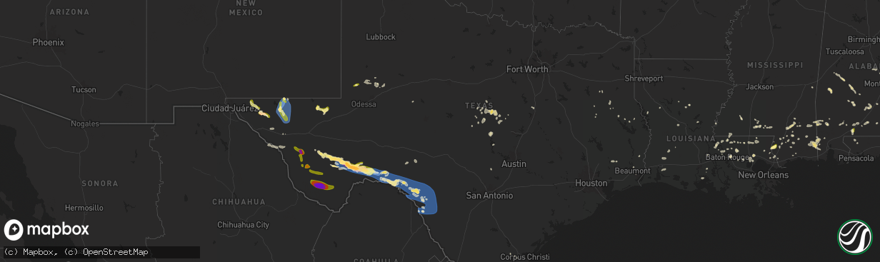
Hail Map in Texas on June 10, 2025
The weather event in Texas on June 10, 2025 includes Wind and Hail maps. 13 states and 365 cities were impacted and suffered possible damage. The total estimated number of properties impacted is 6,027.
Want more than just the map?
Turn this storm into a full workflow.
- Owner + property data so you know who to knock
- OnDemand branded weather history reports to win the "did we even have hail?" argument
- RoofTrace estimate so reps stop guessing numbers at the door
Bought this map? Upgrade within 7 days and we'll credit the $230. (10-15 min setup call)
Wind
Hail
6,027
Estimated number of impacted properties by a 1.00" hail or larger1,065
Estimated number of impacted properties by a 1.75" hail or larger165
Estimated number of impacted properties by a 2.50" hail or largerStorm reports in Texas
Texas
| Date | Description |
|---|---|
| 06/10/20256:43 PM CDT | Mesonet station ur249 6.7 e langtry |
| 06/10/20256:39 PM CDT | A local report indicates 59 MPH wind near 9 SE Hovey |
| 06/10/20256:38 PM CDT | Mesonet station ur144 14.1 sw toyah |
| 06/10/20256:08 PM CDT | A local report indicates 60 MPH wind near 4 NNW Belding |
| 06/10/20255:40 PM CDT | Mesonet station twb49 11.2 ne van horn |
| 06/10/20255:01 PM CDT | Awos station k6r6 5 w dryden recorded a storm-related gust of 93mph. |
| 06/10/20254:45 PM CDT | Estimated 70mph winds accompanied by small hail. |
| 06/10/20254:45 PM CDT | Uprooted tree. |
| 06/10/20254:37 PM CDT | Mesonet station 60 pine springs gmnp. |
| 06/10/20254:22 PM CDT | A local report indicates 58 MPH wind near Persimmon Gap |
| 06/10/20254:00 PM CDT | A local report indicates 58 MPH wind near 19 S Marfa |
| 06/10/20253:43 PM CDT | Quarter to ping pong ball sized hail reported by storm chaser near rm 169 and us 67. |
| 06/10/20253:09 PM CDT | [landspout] storm chaser reported large landspout moving southwest near paisano pass. |
| 06/10/20251:01 PM CDT | Andrews police department measured 1.25 inch hail. |
| 06/09/202511:20 PM CDT | Metal roofing material peeled of mobile home and garage. |
| 06/09/202511:05 PM CDT | Nws cooperative observer reported widespread thunderstorm wind damage in sabinal including broken power poles... Downed trees... Damaged and destroyed outbuildings... A |
| 06/09/202511:05 PM CDT | Nws cooperative observer reporte |
| 06/09/202511:05 PM CDT | Nws cooperative observer reported widespread thunderstorm wind damage in sabinal including broken power poles.. |
| 06/09/202510:15 PM CDT | Mesonet station tw101 camp eagle. |
| 06/09/20259:20 PM CDT | Emergency manager reports tree limbs down and power outages. |
| 06/09/20258:23 PM CDT | Asos station kdrt del rio intl airport. |
| 06/09/20257:50 PM CDT | A local report indicates 69 MPH wind near 3 NW Fort Stockton |
| 06/09/20257:35 PM CDT | A local report indicates 61 MPH wind near 1 ENE Thorntonville |
| 06/09/20257:35 PM CDT | A local report indicates 61 MPH wind near 1 ENE Thorntonville |
| 06/09/20257:05 PM CDT | Mesonet station twb47 13.9 se toyah lake |
| 06/09/20257:00 PM CDT | Mesonet station twb98 gray ranch. |
All States Impacted by Hail Map on June 10, 2025
Cities Impacted by Hail Map on June 10, 2025
- Early, TX
- Zephyr, TX
- Richland Springs, TX
- Mullin, TX
- Blanket, TX
- Comanche, TX
- Brownwood, TX
- Goldthwaite, TX
- San Saba, TX
- Hamilton, TX
- Pottsville, TX
- Priddy, TX
- Evant, TX
- Lampasas, TX
- Burnet, TX
- Purmela, TX
- Waco, TX
- West, TX
- Elm Mott, TX
- Grapeland, TX
- San Augustine, TX
- Rusk, TX
- Bronson, TX
- Boyce, LA
- Elmer, LA
- Andrews, TX
- Chireno, TX
- Many, LA
- Marathon, TX
- Ruidoso, NM
- Tarzan, TX
- Victoria, TX
- Nacogdoches, TX
- Mescalero, NM
- Alto, NM
- Zwolle, LA
- Mount Enterprise, TX
- Gulfport, MS
- Stanton, TX
- Cushing, TX
- Wilmington, NC
- Leland, NC
- Winnabow, NC
- Castle Hayne, NC
- Hampstead, NC
- Rocky Point, NC
- Holly Ridge, NC
- Fort Davis, TX
- Lenorah, TX
- Biloxi, MS
- Melbourne, FL
- Sneads Ferry, NC
- Jacksonville, NC
- Jena, LA
- Hubert, NC
- Whitesburg, GA
- Robeline, LA
- Natchitoches, LA
- Mobile, AL
- Carrollton, GA
- Ponchatoula, LA
- Robert, LA
- Loranger, LA
- Lucedale, MS
- Krotz Springs, LA
- Alpine, TX
- Pinon, NM
- Kokomo, MS
- Tylertown, MS
- Moss Point, MS
- Bush, LA
- Covington, LA
- Carrizozo, NM
- Saint Francisville, LA
- Troup, TX
- Lamesa, TX
- Wilmer, AL
- Marietta, GA
- Foxworth, MS
- Kennesaw, GA
- Vidalia, LA
- Newnan, GA
- Jay, FL
- Palmetto, GA
- Jarreau, LA
- Oscar, LA
- Lakeland, LA
- Immokalee, FL
- Picayune, MS
- Carriere, MS
- Geneva, AL
- New Roads, LA
- Erwinville, LA
- Baton Rouge, LA
- Morganza, LA
- Broaddus, TX
- Lake Wales, FL
- Hammond, LA
- Rougon, LA
- Cumming, GA
- Ethel, LA
- Columbia, MS
- Leakesville, MS
- Port Allen, LA
- Chunchula, AL
- Perkinston, MS
- Wiggins, MS
- McIntosh, AL
- Greensburg, LA
- Jackson, LA
- Donalsonville, GA
- Slaughter, LA
- Clinton, LA
- Alpharetta, GA
- Atmore, AL
- Uriah, AL
- Port Neches, TX
- Andalusia, AL
- Red Level, AL
- Iron City, GA
- Moore Haven, FL
- Georgetown, LA
- Citronelle, AL
- Little River, AL
- Forkland, AL
- Meadville, MS
- Tularosa, NM
- Flomaton, AL
- Poplarville, MS
- Amite, LA
- Fluker, LA
- Roseland, LA
- Kentwood, LA
- Elba, AL
- Richton, MS
- Beaumont, MS
- Lumberton, MS
- Wagarville, AL
- Denham Springs, LA
- Pine Grove, LA
- Walker, LA
- Saratoga, TX
- Centreville, MS
- Norwood, LA
- Port Arthur, TX
- Vinegar Bend, AL
- State Line, MS
- Mount Hermon, LA
- Brewton, AL
- Venus, FL
- Cleveland, TX
- Cloudcroft, NM
- Dell City, TX
- Valentine, TX
- Fruitdale, AL
- Vidor, TX
- Tullos, LA
- Greensboro, AL
- Gallion, AL
- Winnfield, LA
- Punta Gorda, FL
- Purvis, MS
- Hattiesburg, MS
- Brooklyn, MS
- Franklinton, LA
- Mccomb, MS
- Okeechobee, FL
- Conyers, GA
- Loganville, GA
- Marfa, TX
- Range, AL
- Repton, AL
- Oberlin, LA
- Zolfo Springs, FL
- Tibbie, AL
- Faunsdale, AL
- Livingston, LA
- Arcadia, FL
- Oxford, GA
- Summit, MS
- Greenwood, FL
- Grand Ridge, FL
- Marianna, FL
- Deer Park, AL
- Forest Home, AL
- Greenville, AL
- Reeves, LA
- Roswell, NM
- Auburn, GA
- Winder, GA
- Castleberry, AL
- Evergreen, AL
- Springfield, LA
- Fort Stockton, TX
- Dryden, TX
- Jack, AL
- Pendergrass, GA
- Lake Charles, LA
- Georgiana, AL
- Artesia, NM
- Jayess, MS
- Lake Arthur, NM
- Lenox, AL
- Midland City, AL
- Petal, MS
- Dozier, AL
- Kinder, LA
- Commerce, GA
- Bigfork, MT
- Fort Hancock, TX
- New Augusta, MS
- Avon Park, FL
- Saint Augustine, FL
- Elkton, FL
- Brantley, AL
- Headland, AL
- Hagerman, NM
- Ragley, LA
- Salt Flat, TX
- Safford, AL
- Wauchula, FL
- Dacula, GA
- Bogue Chitto, MS
- Ruth, MS
- McHenry, MS
- Cairo, GA
- Glenwood, AL
- Saint Martinville, LA
- Carlsbad, NM
- Sanderson, TX
- Call, TX
- Shorterville, AL
- Camden, AL
- Troy, AL
- Columbia, AL
- Beatrice, AL
- Vredenburgh, AL
- Brundidge, AL
- Bell City, LA
- Chatom, AL
- Coy, AL
- Maiden, NC
- Ovett, MS
- Denver, NC
- Sierra Blanca, TX
- Lakeland, FL
- Auburndale, FL
- Orrville, AL
- Abita Springs, LA
- Pearl River, LA
- Iowa, LA
- New Iberia, LA
- Van Horn, TX
- Davidson, NC
- Mooresville, NC
- Cornelius, NC
- Polk City, FL
- Pennington, AL
- Stennis Space Center, MS
- Winston, GA
- New Brockton, AL
- Opp, AL
- Gantt, AL
- Minter, AL
- Vero Beach, FL
- Bluffton, GA
- Edison, GA
- Douglasville, GA
- Orlando, FL
- Sweet Water, AL
- Moultrie, GA
- Pavo, GA
- Berlin, GA
- Meridian, MS
- Huntersville, NC
- Comstock, TX
- Maljamar, NM
- Semmes, AL
- Gotha, FL
- Windermere, FL
- Ocoee, FL
- Winter Garden, FL
- Mentone, TX
- Pecos, TX
- Deatsville, AL
- Titus, AL
- Adel, GA
- Marbury, AL
- Termo, CA
- Concord, NC
- Mount Pleasant, NC
- Jal, NM
- Madeline, CA
- Albany, GA
- Wetumpka, AL
- Montague, CA
- Zachary, LA
- Albemarle, NC
- Verbena, AL
- New London, NC
- Locust, NC
- Fort McCoy, FL
- Del Rio, TX
- Clanton, AL
- Billingsley, AL
- Astor, FL
- Crescent City, FL
- Georgetown, FL
- McCall Creek, MS
- Park City, MT
- Rocksprings, TX
- Dairy, OR
- Klamath Falls, OR
- Gibson, GA
- Mitchell, GA
- Smithdale, MS
- Holden, LA
- Ozona, TX
- Leesburg, GA
- Richfield, NC
- Avera, GA
- Stapleton, GA
- Sonora, TX
- Brackettville, TX
- Tallassee, AL
- Kissimmee, FL
- Browning, MT
- Laughlin Afb, TX
- Chiloquin, OR
- Moore, MT
- Buffalo, MT
- Lavina, MT
- Roundup, MT
- Waynesville, GA
- Loving, NM
- Lewistown, MT
- Hobson, MT
- Valier, MT
- Quemado, TX
- Christoval, TX
- Sterling City, TX
- Uvalde, TX
- La Pryor, TX
- Broken Arrow, OK
- Tulsa, OK
- Bixby, OK
- Tulelake, CA
- Blanco, TX
- Sprague River, OR
- Gatesville, TX
- Lometa, TX
- San Ygnacio, TX
- Zapata, TX
- Mirando City, TX
- Roma, TX
- West Point, IA
- Batavia, IA
- Libertyville, IA
- Fairfield, IA
- Hillsboro, IA
- Salem, IA
- Donnellson, IA
- Fort Madison, IA
- Ottumwa, IA
- Robstown, TX


