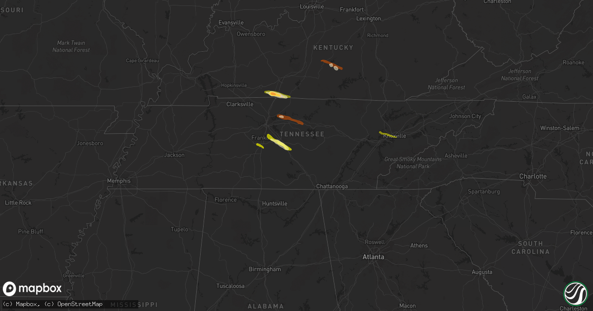
Hail Map in Tennessee on June 10, 2013
Get this storm
June 10 map
$229
one time, instant access
Download today. No call, no setup
Keep the $229
Bought the map and want the full workflow? Apply the entire $229 to a subscription within 7 days. None of it is wasted.
Every map, not just this one
This buys you this map. Subscription and you get every map we run, in the markets you choose from a few cities to whole states to nationwide. Plus real-time alerts the moment a storm fires.
Contact data
Name, contact info, occupancy, even credit band for addresses in the footprint. You go from where it hit to who to call.
Become the source they trust
Unlimited branding weather history reports on demand. You already have the documented answer ready for the property owner, and you are the one who showed up with it.
Property data and RoofTrace estimates
Pull up any address you have got, its value and the exact code rules for that jurisdiction, straight from One Click Code. Then RoofTrace estimates the squares, pitch, and roof value, priced the way you price.
Storm reports in Tennessee
Tennessee
| Date | Description |
|---|---|
| 06/10/20136:45 PM CDT | Trees down across county. |
| 06/10/20136:25 PM CDT | Several trees and power lines down on byington solway rd. |
| 06/10/20136:22 PM CDT | A local report indicates 1.00 inch wind near KARNS |
| 06/10/20134:20 PM CDT | Tree blown down in poplar grove community |
| 06/10/20134:15 PM CDT | Several barns and outbuildings damaged in summitville with numerous trees blown down. |
| 06/10/20134:10 PM CDT | Nws storm survey concluded that damage along minkslide rd and hwy 82 was due to a microburst. Dozens of large trees uprooted with smaller limbs snapped and small trees |
| 06/10/20134:06 PM CDT | Quarter sized hail at exit 276 off of interstate 40 west of cookeville |
| 06/10/20134:06 PM CDT | Trees down along hwy 53 |
| 06/10/20133:45 PM CDT | Several trees down and snapped along opossum paw rd. In beechgrove... Tn |
| 06/10/20133:41 PM CDT | Gainesboro city police reported that the roof of the old city hall building collapsed and trees are down on rooftops and out buildings. |
| 06/10/20133:40 PM CDT | Trees down and phone lines down county wide. Numerous trees down across roadways. |
| 06/10/20133:28 PM CDT | Trees and power lines down. Minor barn damage in same area. |
| 06/10/20133:25 PM CDT | One inch hail reported at blackman farms in murfreesboro |
| 06/10/20133:24 PM CDT | Tree down in barfield. |
| 06/10/20133:19 PM CDT | Multiple trees down near hwy 96 and veterans pike west of murfreesboro |
| 06/10/20133:19 PM CDT | Trees down on cason lane |
| 06/10/20133:16 PM CDT | Person trapped in car with tree on it near hwy 96 and royal glenn road. |
| 06/10/20133:13 PM CDT | Quarter sized hail reported south of nolensville |
| 06/10/20133:10 PM CDT | Trees down in spring hill |
| 06/10/20133:10 PM CDT | Siding blown off of a house. |
| 06/10/20133:10 PM CDT | An nws storm survey team determined that damage in far southern williamson county was a result of intense straight line wind damage from a microburst. Many large trees |
| 06/10/20133:05 PM CDT | Trees down on ramsey lane near tuckers crossroads area |
| 06/10/20133:00 PM CDT | Tspotter report of two trees down in the thompson station area. Cherry grove subdivision on buckner road and aston creek subdivision on hansford and lafayette roads. |
| 06/10/20133:00 PM CDT | Several trees and powerlines down on spanntown road in triune |
| 06/10/20132:57 PM CDT | Tree down on a glass company. Homes in same area with minor wind damage and some power lines down. |
| 06/10/20132:57 PM CDT | Tree on power line on big springs road. |
| 06/10/20132:51 PM CDT | Trees down in the coles ferry area in wilson county |
| 06/10/20132:46 PM CDT | Downed trees reported in antioch around i-24 and blue hole road |
| 06/10/20132:42 PM CDT | Trees and power lines down on split log road and tuscany way |
| 06/10/20132:37 PM CDT | Fallen tree on a structure in the grassland community |
| 06/10/20132:23 PM CDT | Tree blown down in downtown nashville. |
Cities Impacted by Hail Map on June 10, 2013
- Franklin, KY
- Westmoreland, TN
- Portland, TN
- Lebanon, TN
- Mount Juliet, TN
- Christiana, TN
- Arrington, TN
- Nolensville, TN
- College Grove, TN
- Rockvale, TN
- Smyrna, TN
- Murfreesboro, TN
- Adairville, KY
- Adolphus, KY
- Russellville, KY
- Columbia, KY
- Campbellsville, KY
- Knifley, KY
- Empire, NV
- Manter, KS
- Russell Springs, KY
- Greensburg, KY
- Dunnville, KY
- Gallatin, TN
- Gordonsville, TN
- Brush Creek, TN
- Carthage, TN
- Hickman, TN
- Watertown, TN
- Readyville, TN
- Beechgrove, TN
- Franklin, TN
- Brentwood, TN
- Thompsons Station, TN
- Spring Hill, TN
- Oak Ridge, TN
- Knoxville, TN


