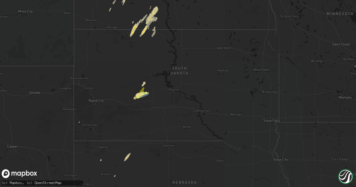
Hail Map in South Dakota on June 9, 2026
Get this storm
June 9 map
$229
one time, instant access
Download today. No call, no setup
Keep the $229
Bought the map and want the full workflow? Apply the entire $229 to a subscription within 7 days. None of it is wasted.
Every map, not just this one
This buys you this map. Subscription and you get every map we run, in the markets you choose from a few cities to whole states to nationwide. Plus real-time alerts the moment a storm fires.
Contact data
Name, contact info, occupancy, even credit band for addresses in the footprint. You go from where it hit to who to call.
Become the source they trust
Unlimited branding weather history reports on demand. You already have the documented answer ready for the property owner, and you are the one who showed up with it.
Property data and RoofTrace estimates
Pull up any address you have got, its value and the exact code rules for that jurisdiction, straight from One Click Code. Then RoofTrace estimates the squares, pitch, and roof value, priced the way you price.
Storm reports in South Dakota
South Dakota
| Date | Description |
|---|---|
| 06/09/202611:48 AM CDT | 1 tree down. Report via social media. Time estimated via radar. |
| 06/09/202611:32 AM CDT | Several trees down in town... Particularly on north washington street and 15th avenue northeast. |
| 06/09/20261:36 AM CDT | The kingsbury county em reported 3 overturned campers in martens campground near lake thompson. |
| 06/09/20261:35 AM CDT | Significant tree damage along 465th avenue. |
| 06/09/20261:34 AM CDT | Kingsbury county reported multiple trees uprooted and branches down in both de smet and arlington. |
| 06/09/20261:30 AM CDT | Kingsbury county em reported downed powerlines in lake preston. |
| 06/09/20261:12 AM CDT | 60 to 80 mph wind gust. |
| 06/09/20261:12 AM CDT | Lots of branches down. A few trees split and fell. |
| 06/09/20261:12 AM CDT | 60-80 mph gusts. |
| 06/09/202612:59 AM CDT | Mesonet station 291 altamont 4n |
| 06/09/202612:49 AM CDT | Time estimated by radar. |
| 06/09/202612:49 AM CDT | Multiple trees uprooted. |
| 06/09/202612:48 AM CDT | Photo sent of a tree down in clear lake. Time estimated by radar. |
| 06/09/202612:45 AM CDT | Trained spotter sent photos of trees down at 470th ave and south dakota highway 22. Time estimated by radar. |
| 06/09/202612:45 AM CDT | Trained spotter reports roofing and siding damage to a home in bemis due to wind. Time estimated by radar. |
| 06/09/202612:45 AM CDT | A personal weather station just northeast of volga recorded a wind gust of 68 mph. |
| 06/09/202612:44 AM CDT | Trained spotter sent photos and video of multiple large trees snapped or uprooted at and near the intersection of 179th street and 468th ave. Part of 179th street appea |
| 06/09/202612:36 AM CDT | A local report indicates 70 MPH wind near 2 SW Stone Bridge |
| 06/09/202612:34 AM CDT | Image relayed via facebook of multiple trees being uprooted. |
| 06/09/202612:34 AM CDT | Mesonet station mrls2 hillhead 3 wsw. |
| 06/09/202612:33 AM CDT | Trained spotter reports multiple irrigation pivots damaged due to wind. Time estimated by radar. |
| 06/09/202612:30 AM CDT | Mesonet station fw0832 estelline. |
| 06/09/202612:29 AM CDT | An sddot just south of arlington recorded a 72 mph wind gust. |
| 06/09/202612:25 AM CDT | A personal weather station just south of badger recorded a 68 mph wind gust. |
| 06/09/202612:18 AM CDT | Received a social media report of quarter sized hail in aurora. Time estimated via radar. |
| 06/09/202612:15 AM CDT | Corrects previous tstm wnd dmg report from lake preston. Kingsbury county em reported downed powerlines in lake preston. |
| 06/09/202612:15 AM CDT | Mesonet station btms2 britton 7e |
| 06/09/202612:14 AM CDT | A sddot site near arlington recorded a 68 mph wind gust. |
| 06/09/202612:13 AM CDT | Corrects previous tstm wnd dmg report from 5 wsw lake preston. The kingsbury county em reported 3 overturned campers in martens campground near lake thompson. |
| 06/09/202612:13 AM CDT | Personal weather station at lake henry campground. |
| 06/09/202612:10 AM CDT | An sddot site near alpena recorded a wind gust of 63 mph. |
| 06/09/202612:09 AM CDT | An sddot site near arlington recorded a 66 mph wind gust. |
| 06/09/202612:07 AM CDT | Corrects previous tstm wnd gst report from 4 s arlington. An sddot site near arlington recorded a 66 mph wind gust. |
| 06/09/202612:06 AM CDT | A local report indicates a tornado near Henry |
| 06/09/202612:05 AM CDT | Corrects previous tstm wnd dmg report from de smet. Kingsbury county reported multiple trees uprooted and branches down in de smet. |
| 06/08/202611:50 PM CDT | Mesonet station gots2 groton 9 nne |
| 06/08/202611:34 PM CDT | Roof damage from winds to a large barn... Report relayed via slack. Time estimated by radar. |
| 06/08/202611:33 PM CDT | Photo and video of trees that have fallen down from the wind onto a home and another one onto a car. Time estimated by radar. |
| 06/08/202611:33 PM CDT | Report via social media. Time estimated by radar. |
| 06/08/202611:32 PM CDT | Asos station kabr aberdeen rgnl ap. |
| 06/08/202611:31 PM CDT | An sddot site west of plankinton recorded a 67 mph wind gust. |
| 06/08/202611:30 PM CDT | Photo of machine shed roof damage and door blown in relayed via slack. |
| 06/08/202611:28 PM CDT | A personal weather station just north of mitchell recorded a 67 mph wind gust. |
| 06/08/202611:27 PM CDT | A local report indicates 78 MPH wind near 2 WNW Richmond Lake Rec |
| 06/08/202611:19 PM CDT | A personal weather station northeast of platte recorded a 76 mph wind gust. |
| 06/08/202611:19 PM CDT | A personal weather station northwest of ethan recorded a 64 mph wind gusts. |
| 06/08/202611:15 PM CDT | A local report indicates 70 MPH wind near 3 NE Redfield |
| 06/08/202611:15 PM CDT | Awos station k1d8 redfield muni ap. |
| 06/08/202611:15 PM CDT | A local report indicates 70 MPH wind near 1 NE Mina |
| 06/08/202611:15 PM CDT | Mesonet station awms2 aberdeen 10wsw |
| 06/08/202611:14 PM CDT | Mesonet station 175 mellette |
| 06/08/202611:12 PM CDT | A personal weather station near platte recorded a 67 mph wind gust. |
| 06/08/202611:09 PM CDT | The fort randall dam recorded a 65 mph wind gust. |
| 06/08/202611:06 PM CDT | A personal weather station near armour reported a 73 mph wind gust. |
| 06/08/202611:05 PM CDT | Mesonet station 315 cresbard |
| 06/08/202611:01 PM CDT | A personal weather station near herrick recorded a wind gust of 65 mph. |
| 06/08/202610:56 PM CDT | A personal weather station near lake andes recorded a 59 mph wind gust. |
| 06/08/202610:55 PM CDT | Corrects previous tstm wnd gst report from 6 nne herrick. A personal weather station near herrick recorded a wind gust of 65 mph. |
| 06/08/202610:54 PM CDT | Mesonet station rhus2 danforth 5 e... Time estimated from radar. |
| 06/08/202610:50 PM CDT | Mesonet station rhms2 rockham 6sse |
| 06/08/202610:49 PM CDT | Mesonet station 158 miranda |
| 06/08/202610:45 PM CDT | Mesonet station wgms2 wessington 3w |
| 06/08/202610:44 PM CDT | Mesonet station rhus2 danforth 5 e. Time estimated. |
| 06/08/202610:44 PM CDT | A local report indicates 77 MPH wind near Faulkton |
| 06/08/202610:43 PM CDT | A personal weather station near bonesteel recorded a 58 mph wind gusts. |
| 06/08/202610:43 PM CDT | A personal weather station near fairfax recorded a 72.9 mph wind gust. |
| 06/08/202610:43 PM CDT | A personal weather station near fairfax recorded a 60 mph wind gust. |
| 06/08/202610:38 PM CDT | A personal weather station near fairfax recorded a 69 mph wind gust. |
| 06/08/202610:32 PM CDT | Report also included some small hail. |
| 06/08/202610:31 PM CDT | Winds close to 60mph from the outflow boundary that passed before the storm came in. Radar estimated time: 10:31pm. |
| 06/08/202610:25 PM CDT | Mesonet station 312 ree heights |
| 06/08/202610:13 PM CDT | Mesonet station 183 macs corner |
| 06/08/202610:05 PM CDT | Mesonet station lbms2 lower brule 2wnw |
| 06/08/20269:45 PM CDT | Report also includes some pea sized hail. |
| 06/08/20269:35 PM CDT | Mesonet station pims2 pierre 17e |
| 06/08/20269:30 PM CDT | A local report indicates 65 MPH wind near 4 WSW Blunt |
| 06/08/20269:12 PM CDT | A local report indicates 1.00 inch wind near Fort Pierre |
| 06/08/20268:44 PM CDT | A local report indicates 60 MPH wind near 2 N White River |
| 06/08/20268:05 PM CDT | Pea to nickel size hail. |
| 06/08/20267:41 PM CDT | A local report indicates 60 MPH wind near 5 ENE Martin |
| 06/08/20267:35 PM CDT | A local report indicates 66 MPH wind near 4 ENE Martin |
| 06/08/20267:30 PM CDT | A local report indicates 64 MPH wind near 4 ENE Martin |
| 06/08/20267:15 PM CDT | A local report indicates 66 MPH wind near 10 WSW Ottumwa |
| 06/08/20267:08 PM CDT | A local report indicates 1.00 inch wind near 14 N Philip |
All States Impacted by Hail Map on June 9, 2026
Cities Impacted by Hail Map on June 9, 2026
- La Harpe, KS
- Wildrose, ND
- Ray, ND
- Tioga, ND
- Mcgregor, ND
- Plymouth, IL
- Colchester, IL
- Industry, IL
- Macomb, IL
- Bardwell, KY
- Freeland, MI
- Wickliffe, KY
- Paris, TN
- Gleason, TN
- Springville, TN
- Springfield, TN
- Greenbrier, TN
- Puryear, TN
- Cottage Grove, TN
- Neelyville, MO
- Southgate, MI
- Wyandotte, MI
- White House, TN
- McKenzie, TN
- Arlington, KY
- Concord, GA
- Cross Plains, TN
- Fancy Farm, KY
- Mayfield, KY
- Williamson, GA
- Tiptonville, TN
- Goodlettsville, TN
- Franklin, KY
- Big Sandy, TN
- Luverne, AL
- Hendersonville, TN
- Cottontown, TN
- Wingo, KY
- Auburn, KY
- Russellville, KY
- Cumberland City, TN
- Erin, TN
- Morgantown, KY
- Sedalia, KY
- Beaver Dam, KY
- Farmington, KY
- Indian Mound, TN
- Oakland, KY
- Bowling Green, KY
- Santa Rosa, NM
- Murray, KY
- Kirksey, KY
- Palmyra, TN
- Pueblo, CO
- Clarksville, TN
- Woodlawn, TN
- Henry, TN
- Greenville, AL
- Cheyenne Wells, CO
- Conchas Dam, NM
- Garita, NM
- Boone, CO
- Arapahoe, CO
- Ulysses, KS
- Trementina, NM
- Satanta, KS
- Cuervo, NM
- Chapmansboro, TN
- Cedar Hill, TN
- Lineville, AL
- Guthrie, KY
- Trenton, KY
- Elkton, KY
- Moscow, KS
- Pleasant View, TN
- Ashland City, TN
- Adams, TN
- Joelton, TN
- Trenton, UT
- Adairville, KY
- Olmstead, KY
- Richardton, ND
- Garden City, KS
- Felt, OK
- Allensville, KY
- Mosquero, NM
- Clarkston, UT
- Cornish, UT
- Hebron, ND
- Beulah, ND
- New England, ND
- Richmond, UT
- Dighton, KS
- Dresden, TN
- Sterling, CO
- Healy, KS
- Zap, ND
- Cimarron, KS
- Sublette, KS
- Hugoton, KS
- Edgemont, SD
- Johnson, KS
- Sidney, NE
- Lemmon, SD
- Old Hickory, TN
- Hermitage, TN
- Madison, TN
- Nashville, TN
- Mount Juliet, TN
- Williston, ND
- Mott, ND
- Zahl, ND
- Lefor, ND
- Regent, ND
- Antioch, TN
- Smyrna, TN
- La Vergne, TN
- Lebanon, TN
- Murfreesboro, TN
- Ingalls, KS
- Montezuma, KS
- Copeland, KS
- Beeler, KS
- Taylor, ND
- Utica, KS
- Keldron, SD
- Alamo, ND
- Richfield, KS
- Charleston, IL
- Goodland, KS
- Edson, KS
- Brewster, KS
- Colby, KS
- McDonald, KS
- Lascassas, TN
- Watertown, TN
- Milton, TN
- Oberlin, KS
- Elgin, ND
- Ashmore, IL
- Selfridge, ND
- Arnold, KS
- Ransom, KS
- Scott City, KS
- West Lafayette, IN
- Otterbein, IN
- Readyville, TN
- Christiana, TN
- Auburntown, TN
- Woodbury, TN
- Penokee, KS
- Morland, KS
- Hazen, ND
- Glen Ullin, ND
- Westpoint, IN
- Macedonia, IL
- McLeansboro, IL
- New Leipzig, ND
- Paris, IL
- Lafayette, IN
- Bradyville, TN
- Beechgrove, TN
- Ensign, KS
- Dodge City, KS
- Jetmore, KS
- Lenora, KS
- Kansas, IL
- Hill City, KS
- Hemingford, NE
- Marsland, NE
- Halliday, ND
- Manchester, TN
- Morrison, TN
- Stanton, ND
- Prairie View, KS
- Logan, KS
- Almena, KS
- Wheatfield, IN
- Oshkosh, NE
- Golden Valley, ND
- Killdeer, ND
- Toledo, IL
- Greenup, IL
- Bogue, KS
- Roseglen, ND
- Lafayette, AL
- Norton, KS
- Brownell, KS
- Phillipsburg, KS
- Underwood, ND
- Riverdale, ND
- Coleharbor, ND
- Garrison, ND
- Alexander, KS
- Rush Center, KS
- Nekoma, KS
- La Crosse, KS
- Long Island, KS
- Douglas, ND
- Ryder, ND
- Max, ND
- Carson, ND
- Fortuna, ND
- Casey, IL
- Martinsville, IL
- Hanston, KS
- Burdett, KS
- Plaza, ND
- Marshall, IL
- Parshall, ND
- Dodge, ND
- Beaver City, NE
- Orleans, NE
- Stamford, NE
- Alma, NE
- Bison, KS
- Oxford, NE
- Channing, TX
- Adrian, TX
- Hartley, TX
- Watauga, SD
- Brownsburg, IN
- Danville, IN
- Pittsboro, IN
- McIntosh, SD
- Makoti, ND
- Larned, KS
- Minot, ND
- Lewellen, NE
- Big Springs, NE
- Dennison, IL
- Ellis, KS
- Hays, KS
- Atlanta, NE
- Holdrege, NE
- Republican City, NE
- Des Lacs, ND
- Berthold, ND
- Crosby, ND
- Raleigh, ND
- Shields, ND
- Rozel, KS
- West Terre Haute, IN
- Bloomingdale, IN
- Ambrose, ND
- Noonan, ND
- Terre Haute, IN
- Brazil, IN
- Staunton, IN
- Centerpoint, IN
- Knightsville, IN
- Hildreth, NE
- West Union, IL
- Axtell, NE
- Wilcox, NE
- Otis, KS
- Philip, SD
- Midland, SD
- Arthur, NE
- Lemoyne, NE
- Funk, NE
- Naponee, NE
- Henagar, AL
- Victoria, KS
- Catharine, KS
- Plainville, KS
- Columbus, ND
- Kearney, NE
- Elm Creek, NE
- Riverdale, NE
- Upland, NE
- Minden, NE
- Campbell, NE
- Odessa, NE
- Heartwell, NE
- Flasher, ND
- Farmersburg, IN
- Milesville, SD
- Ross, ND
- Stanley, ND
- Grenora, ND
- Shelburn, IN
- New Town, ND
- Pleasanton, NE
- Gibbon, NE
- Holstein, NE
- Kenesaw, NE
- Juniata, NE
- Shelton, NE
- Roseland, NE
- Bladen, NE
- Merriman, NE
- Gordon, NE
- Ellsworth, NE
- Pawnee Rock, KS
- Solen, ND
- Kingston, GA
- Plains, KS
- Reelsville, IN
- Cartersville, GA
- McLaughlin, SD
- Fairbanks, IN
- Greencastle, IN
- Jasonville, IN
- Lewis, IN
- Plentywood, MT
- Walker, SD
- Wood River, NE
- Doniphan, NE
- Wright, KS
- Spearville, KS
- Great Bend, KS
- Hudson, KS
- Ellinwood, KS
- St John, KS
- Claflin, KS
- Raymond, KS
- Hastings, NE
- Benedict, ND
- Ruso, ND
- Sawyer, ND
- Trumbull, NE
- Alda, NE
- Granville, ND
- Norwich, ND
- Velva, ND
- Palermo, ND
- Sullivan, IN
- Merom, IN
- Sutherland, NE
- Tryon, NE
- Antelope, MT
- Portal, ND
- Clay City, IN
- Wanblee, SD
- Saint Anthony, ND
- North Platte, NE
- Bowling Green, IN
- Glenburn, ND
- Surrey, ND
- Bantry, ND
- Deering, ND
- Upham, ND
- Westhope, ND
- Newburg, ND
- Lansford, ND
- Maxbass, ND
- Souris, ND
- Kramer, ND
- Towner, ND
- Mcclusky, ND
- Fort Pierre, SD
- Hayes, SD
- Fort Yates, ND
- Willow City, ND
- Kenmare, ND
- Donnybrook, ND
- Wakpala, SD
- Drake, ND
- Minneola, KS
- Coalmont, IN
- Hymera, IN
- Mullen, NE
- Grand Island, NE
- Phillips, NE
- Giltner, NE
- Aurora, NE
- Hampton, NE
- Marquette, NE
- Chapman, NE
- Hordville, NE
- Central City, NE
- Gladstone, ND
- Polk, NE
- Powers Lake, ND
- Beloit, KS
- Clarks, NE
- Scotia, NE
- Wolbach, NE
- Rugby, ND
- Worthington, IN
- Coal City, IN
- Ansley, NE
- Mason City, NE
- Saint Paul, NE
- Stapleton, NE
- Cedar Rapids, NE
- Westerville, NE
- Arcadia, NE
- Comstock, NE
- Ord, NE
- Ford, KS
- Bushton, KS
- Chase, KS
- Stromsburg, NE
- Indianapolis, IN
- Pendleton, IN
- Mccordsville, IN
- Fortville, IN
- Greenfield, IN
- Broken Bow, NE
- Lignite, ND
- Strasburg, ND
- Cory, IN
- Greeley, NE
- Denhoff, ND
- Goodrich, ND
- Saint Francis, SD
- Linton, ND
- Moffit, ND
- Hazelton, ND
- Bowbells, ND
- Flaxton, ND
- Osceola, NE
- Seneca, NE
- Thedford, NE
- Arnold, NE
- Halsey, NE
- Dunning, NE
- Driscoll, ND
- Wing, ND
- Fullerton, NE
- Martin, ND
- Spalding, NE
- Broadus, MT
- Alzada, MT
- Linton, IN
- Lyons, IN
- Pierre, SD
- Elyria, NE
- Bradshaw, NE
- York, NE
- Shelby, NE
- Benedict, NE
- Ulysses, NE
- Rising City, NE
- Gresham, NE
- Waco, NE
- Surprise, NE
- Balta, ND
- Sargent, NE
- Harvey, ND
- Battle Creek, NE
- Pollock, SD
- Belcourt, ND
- Burwell, NE
- Vivian, SD
- Rolette, ND
- Switz City, IN
- Presho, SD
- Purdum, NE
- David City, NE
- McCool Junction, NE
- Henderson, NE
- Hurdsfield, ND
- Chaseley, ND
- Herreid, SD
- Tucumcari, NM
- Madison, NE
- Meadow Grove, NE
- Saint John, ND
- Newberry, IN
- Rolla, ND
- Mylo, ND
- Carlisle, IN
- Tilden, NE
- Onida, SD
- Taylor, NE
- Saint Edward, NE
- Newman Grove, NE
- Albion, NE
- Petersburg, NE
- Brainard, NE
- Elgin, NE
- Bellwood, NE
- Clearwater, NE
- Oakdale, NE
- Harrold, SD
- Blunt, SD
- Chambers, NE
- Amelia, NE
- Brewster, NE
- Hoisington, KS
- Bisbee, ND
- Mound City, SD
- Esmond, ND
- Ashland, KS
- Plainview, NE
- San Jon, NM
- Norfolk, NE
- York, ND
- Perth, ND
- Bruno, NE
- Weston, NE
- Prague, NE
- Abie, NE
- Linwood, NE
- Malmo, NE
- Maddock, ND
- Holabird, SD
- Leeds, ND
- Minnewaukan, ND
- Pettibone, ND
- Robinson, ND
- Woodworth, ND
- Highmore, SD
- Ree Heights, SD
- Miller, SD
- Hoskins, NE
- Atkinson, NE
- Bassett, NE
- Stuart, NE
- Bunker Hill, KS
- Rocklake, ND
- Protection, KS
- Lower Brule, SD
- Emmet, NE
- Newport, NE
- Reliance, SD
- Wilson, KS
- Dorrance, KS
- Ainsworth, NE
- Utica, NE
- Pierce, NE
- Long Pine, NE
- Bard, NM
- Cando, ND
- Coldwater, KS
- Bee, NE
- Seward, NE
- Westphalia, IN
- Sandborn, IN
- Oberon, ND
- Churchs Ferry, ND
- Starkweather, ND
- Webster, ND
- Penn, ND
- Devils Lake, ND
- Fort Totten, ND
- Sheyenne, ND
- Fessenden, ND
- New Rockford, ND
- Cathay, ND
- Saint Michael, ND
- Russell, KS
- Sylvan Grove, KS
- Ellsworth, KS
- Lincoln, KS
- Fort Thompson, SD
- Gann Valley, SD
- Chamberlain, SD
- Stephan, SD
- Valparaiso, NE
- Raymond, NE
- Ceresco, NE
- Spencer, NE
- Ashley, ND
- Oacoma, SD
- Dwight, NE
- Warwick, ND
- Crary, ND
- Wahoo, NE
- Munich, ND
- Edmore, ND
- Naper, NE
- Mills, NE
- Wessington Springs, SD
- Saint Lawrence, SD
- Wessington, SD
- Brookville, KS
- Kanopolis, KS
- Langdon, ND
- Calvin, ND
- Wagner, SD
- Bristow, NE
- Pukwana, SD
- Wishek, ND
- Fairfax, SD
- Orient, SD
- Correctionville, IA
- Moville, IA
- Faulkton, SD
- Seneca, SD
- Scotland, SD
- Streeter, ND
- Ithaca, NE
- Mead, NE
- Butte, NE
- Lynch, NE
- Oneill, NE
- Bonesteel, SD
- Adams, ND
- Nekoma, ND
- Brocket, ND
- Osnabrock, ND
- Hampden, ND
- Alsen, ND
- Fairdale, ND
- Lakota, ND
- Lawton, ND
- Tulare, SD
- Roscoe, SD
- Rockham, SD
- Cresbard, SD
- Ipswich, SD
- Geddes, SD
- Armour, SD
- Platte, SD
- Saint Charles, SD
- Burke, SD
- Pickstown, SD
- Lake Andes, SD
- Beverly, KS
- Freeman, SD
- Kingsley, IA
- Pierson, IA
- Menno, SD
- Olivet, SD
- Wales, ND
- Carrington, ND
- Grace City, ND
- Yutan, NE
- Gackle, ND
- Delmont, SD
- Mansfield, SD
- Kimball, SD
- Wolsey, SD
- Aberdeen, SD
- Alpena, SD
- Northville, SD
- Virgil, SD
- Westport, SD
- Ashton, SD
- Hitchcock, SD
- Mellette, SD
- Redfield, SD
- Walhalla, ND
- Crystal, ND
- Mountain, ND
- Hensel, ND
- Milton, ND
- Edinburg, ND
- Cavalier, ND
- Neche, ND
- Hoople, ND
- Tolna, ND
- Mchenry, ND
- Glenfield, ND
- Bridgewater, SD
- Marion, SD
- Parkston, SD
- Kensal, ND
- Harrison, SD
- Herrick, SD
- Corsica, SD
- Leola, SD
- Warner, SD
- Elnora, IN
- Forbes, ND
- Fredonia, ND
- Dimock, SD
- Ethan, SD
- Pingree, ND
- Emery, SD
- Alexandria, SD
- Cherokee, IA
- Aurelia, IA
- Canistota, SD
- Mitchell, SD
- Fulton, SD
- Jud, ND
- Ellendale, ND
- Alta, IA
- Courtenay, ND
- Huron, SD
- Pekin, ND
- Barnard, SD
- Frederick, SD
- Bath, SD
- Columbia, SD
- Hecla, SD
- Woonsocket, SD
- Oakes, ND
- Stratford, SD
- Groton, SD
- Houghton, SD
- Claremont, SD
- Brentford, SD
- Frankfort, SD
- Turton, SD
- Conde, SD
- Doland, SD
- Ferney, SD
- Yale, SD
- Andover, SD
- Bristol, SD
- Webster, SD
- Britton, SD
- Clark, SD
- Raymond, SD
- Roslyn, SD
- De Smet, SD
- Carpenter, SD
- Forman, ND
- Willow Lake, SD
- Artesian, SD
- Pierpont, SD
- Iroquois, SD
- Cavour, SD
- Amherst, SD
- Garden City, SD
- Cogswell, ND
- Bradley, SD
- Langford, SD
- New Holland, SD
- White Lake, SD
- Stickney, SD
- Plankinton, SD
- Letcher, SD
- Mount Vernon, SD
- Tripp, SD
- Wallace, SD
- Henry, SD
- Spencer, SD
- Salem, SD
- Winfred, SD
- Fedora, SD
- Carthage, SD
- Oldham, SD
- Canova, SD
- Howard, SD
- Jamestown, ND
- Edgeley, ND
- Berlin, ND
- Montpelier, ND
- Buchanan, ND
- Lake Preston, SD
- Vienna, SD
- Bryant, SD
- Erwin, SD
- Fullerton, ND
- Kathryn, ND
- Spiritwood, ND
- Fort Ransom, ND
- Wimbledon, ND
- Lamoure, ND
- Litchville, ND
- Sanborn, ND
- Dickey, ND
- Stirum, ND
- Gwinner, ND
- Verona, ND
- Ypsilanti, ND
- Marion, ND
- Florence, SD
- Waubay, SD
- Watertown, SD
- Colman, SD
- Rutland, SD
- Michigan, ND
- Valley City, ND
- Nome, ND
- Buffalo, ND
- Cooperstown, ND
- Pillsbury, ND
- Oriska, ND
- Fingal, ND
- Milnor, ND
- Lisbon, ND
- Hannaford, ND
- Rogers, ND
- Tower City, ND
- Clifford, ND
- Luverne, ND
- Galesburg, ND
- Ayr, ND
- Hope, ND
- Dazey, ND
- Enderlin, ND
- Page, ND
- Sheldon, ND
- Havana, ND
- Eden, SD
- Lake City, SD
- Sisseton, SD
- Peever, SD
- Veblen, SD
- Grenville, SD
- Hayti, SD
- Hazel, SD
- South Shore, SD
- Ortley, SD
- Summit, SD
- Lake Norden, SD
- Ramona, SD
- Madison, SD
- Tyler, MN
- Ruthton, MN
- Pipestone, MN
- Aurora, SD
- Sinai, SD
- Wentworth, SD
- Brookings, SD
- Bruce, SD
- Estelline, SD
- Nunda, SD
- Clear Lake, SD
- Castlewood, SD
- Volga, SD
- Arlington, SD
- Badger, SD
- Leonard, ND
- Cayuga, ND
- Lidgerwood, ND
- Wheatland, ND
- Rutland, ND
- Erie, ND
- Claire City, SD
- Mcleod, ND
- Absaraka, ND
- Russell, MN
- Arco, MN
- Lynd, MN
- Lake Benton, MN
- Slayton, MN
- Kranzburg, SD
- Goodwin, SD
- Strandburg, SD
- Twin Brooks, SD
- Stockholm, SD
- Marvin, SD
- Wilmot, SD
- Corona, SD
- Hankinson, ND
- Arthur, ND
- Mapleton, ND
- Amenia, ND
- Mantador, ND
- Kindred, ND
- Wyndmere, ND
- Mooreton, ND
- Walcott, ND
- Browns Valley, MN
- Casselton, ND
- Davenport, ND
- New Effington, SD
- Barney, ND
- Hunter, ND
- Milroy, MN
- Vesta, MN
- Lone Rock, IA
- Whittemore, IA
- Canby, MN
- Ivanhoe, MN
- Porter, MN
- Tracy, MN
- Minneota, MN
- Garvin, MN
- Toronto, SD
- Madison, MN
- Astoria, SD
- Marietta, MN
- Gary, SD
- Brandt, SD
- Revillo, SD
- Clinton, MN
- Dumont, MN
- Beardsley, MN
- Graceville, MN
- Barry, MN
- Ortonville, MN
- Bellingham, MN
- Big Stone City, SD
- Milbank, SD
- Labolt, SD
- Rosholt, SD
- Odessa, MN
- Wheaton, MN
- Hendricks, MN
- Boyd, MN
- Dawson, MN
- Clarkfield, MN
- Taunton, MN
- Fairmount, ND
- Correll, MN
- Appleton, MN
- Montevideo, MN
- Chokio, MN
- Milan, MN
- Watson, MN
- Alberta, MN
- Donnelly, MN
- Tintah, MN
- Abercrombie, ND
- Wahpeton, ND
- Colfax, ND
- Christine, ND
- Campbell, MN
- Kent, MN
- Holloway, MN
- Morris, MN
- Norcross, MN
- Breckenridge, MN
- Wolverton, MN
- Herman, MN
- Wabasso, MN
- Springfield, MN
- Comfrey, MN
- Marshall, MN
- Belview, MN
- Darfur, MN
- Butterfield, MN
- Redwood Falls, MN
- Sanborn, MN
- Echo, MN
- White, SD
- Morgan, MN
- Clements, MN
- Bancroft, IA
- Burt, IA
- Stephen, MN
- Sleepy Eye, MN
- Barrett, MN
- Comstock, MN
- Nashua, MN
- Fergus Falls, MN
- Murdock, MN
- Moorhead, MN
- Danvers, MN
- Wendell, MN
- Clara City, MN
- Raymond, MN
- Hoffman, MN
- Rothsay, MN
- Clontarf, MN
- Barnesville, MN
- Benson, MN
- Maynard, MN
- Elbow Lake, MN
- Starbuck, MN
- Foxhome, MN
- Hancock, MN
- Kerkhoven, MN
- Horace, ND
- Sabin, MN
- Cyrus, MN
- Morton, MN
- Fairfax, MN
- Renville, MN
- Danube, MN
- Vernon Center, MN
- Garden City, MN
- Nicollet, MN
- Gibbon, MN
- Hector, MN
- Buffalo Lake, MN
- Mapleton, MN
- Lake Crystal, MN
- Mankato, MN
- Olivia, MN
- Bird Island, MN
- Ghent, MN
- Brownton, MN
- Gaylord, MN
- Winthrop, MN
- Buxton, ND
- Pelican Rapids, MN
- Sunburg, MN
- Pemberton, MN
- Janesville, MN
- Kensington, MN
- Reynolds, ND
- Farwell, MN
- Stewart, MN
- Lowry, MN
- Elysian, MN
- Madison Lake, MN
- New Prague, MN
- Montgomery, MN
- Ashby, MN
- Evansville, MN
- Jordan, MN
- Flandreau, SD
- Rochert, MN
- Savage, MN
- Elko New Market, MN
- Prior Lake, MN
- Shakopee, MN
- Lonsdale, MN
- Lakeville, MN
- Strathcona, MN
- Detroit Lakes, MN
- Avon, MN
- Sauk Rapids, MN
- Wadena, MN
- Callaway, MN
- Burnsville, MN
- Minneapolis, MN
- Saint Paul, MN
- Holdingford, MN
- Albany, MN
- Park Rapids, MN
- Fosston, MN
- Milaca, MN
- Foreston, MN
- Oak Park, MN
- Bowlus, MN
- Pierz, MN
- Royalton, MN
- Sartell, MN
- Osage, MN
- Rice, MN
- Hillman, MN
- Ogilvie, MN
- Ponsford, MN
- Rush City, MN
- Solway, MN
- Pequot Lakes, MN
- Shevlin, MN
- Laporte, MN
- Mora, MN
- Bemidji, MN
- Grantsburg, WI
- Pine City, MN
- Almena, WI
- Clayton, WI
- Dallas, WI
- Barron, WI
- Durand, WI
- Blackduck, MN
- Chippewa Falls, WI
- Bloomer, WI
- Ponemah, MN
- Kelliher, MN
- Kellogg, MN
- Wabasha, MN
- Alma, WI
- Mondovi, WI
- Jim Falls, WI
- Waskish, MN
- Eleva, WI
- Cornell, WI
- Cadott, WI
- Arcadia, WI
- Cochrane, WI
- Turtle Lake, WI
- Eau Claire, WI
- Fall Creek, WI
- Independence, WI
- Strum, WI
- Gilman, WI
- Woodville, WI
- Glenwood City, WI
- Augusta, WI
- Osseo, WI
- Whitehall, WI
- Fairchild, WI
- Boyd, WI
- Boyceville, WI
- Downing, WI
- Blair, WI
- Ettrick, WI
- Taylor, WI
- Willard, WI
- Stanley, WI
- Thorp, WI
- Greenwood, WI
- Hixton, WI
- Merrillan, WI
- Humbird, WI
- Owen, WI
- Loyal, WI
- Mankato, KS
- Black River Falls, WI
- Alma Center, WI
- Neillsville, WI
- Withee, WI
- Spencer, WI
- Dorchester, WI
- Curtiss, WI
- Medford, WI
- Colby, WI
- Abbotsford, WI
- Stetsonville, WI
- Unity, WI
- Edgar, WI
- Stratford, WI
- Athens, WI
- Fargo, ND
- Argusville, ND
- West Fargo, ND
- Georgetown, MN
- Felton, MN
- Dilworth, MN
- Glyndon, MN
- Dalton, MN
- Elizabeth, MN
- Harwood, ND
- Glenwood, MN
- Pennock, MN
- Willmar, MN
- Erhard, MN
- Twin Valley, MN
- Hitterdal, MN
- Underwood, MN
- Ulen, MN
- Hawley, MN
- Lake Park, MN
- Ada, MN
- Borup, MN
- West Union, MN
- Brooten, MN
- Vining, MN
- Frazee, MN
- Ottertail, MN
- Dent, MN
- Osakis, MN
- Sauk Centre, MN
- Henning, MN
- Miltona, MN
- Carlos, MN
- Long Prairie, MN
- Brandon, MN
- Battle Lake, MN
- Alexandria, MN
- Richville, MN
- Vergas, MN
- Audubon, MN
- Villard, MN
- Eagle Bend, MN
- Parkers Prairie, MN
- Clitherall, MN
- Perham, MN
- Nelson, MN
- Garfield, MN
- Fertile, MN
- New York Mills, MN
- Bluffton, MN
- Mahnomen, MN
- Motley, MN
- Menahga, MN
- Browerville, MN
- Ogema, MN
- Waubun, MN
- Bertha, MN
- Clarissa, MN
- Pine River, MN
- Verndale, MN
- Gary, MN
- Deer Creek, MN
- Sebeka, MN
- Hewitt, MN
- Staples, MN
- Aldrich, MN
- White Earth, MN
- Naytahwaush, MN
- Bejou, MN
- Bagley, MN
- Ravenna, NE
- Cairo, NE
- Dannebrog, NE
- Boelus, NE
- Silver Creek, NE
- Palmer, NE
- Rockville, NE
- Archer, NE
- Saint Libory, NE
- Ayr, NE
- Harvard, NE
- Amherst, NE
- Hazard, NE
- Randolph, NE
- Island Park, ID


