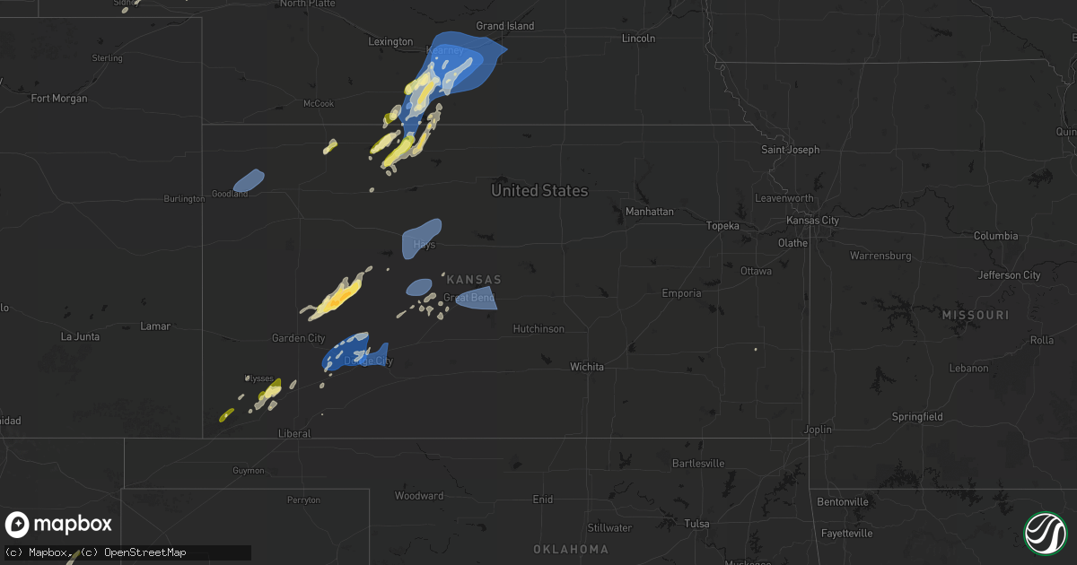
Hail Map in Kansas on June 9, 2026
Get this storm
June 9 map
$229
one time, instant access
Download today. No call, no setup
Keep the $229
Bought the map and want the full workflow? Apply the entire $229 to a subscription within 7 days. None of it is wasted.
Every map, not just this one
This buys you this map. Subscription and you get every map we run, in the markets you choose from a few cities to whole states to nationwide. Plus real-time alerts the moment a storm fires.
Contact data
Name, contact info, occupancy, even credit band for addresses in the footprint. You go from where it hit to who to call.
Become the source they trust
Unlimited branding weather history reports on demand. You already have the documented answer ready for the property owner, and you are the one who showed up with it.
Property data and RoofTrace estimates
Pull up any address you have got, its value and the exact code rules for that jurisdiction, straight from One Click Code. Then RoofTrace estimates the squares, pitch, and roof value, priced the way you price.
Storm reports in Kansas
Kansas
| Date | Description |
|---|---|
| 06/09/20266:47 PM CDT | A local report indicates 65 MPH wind near 3 SW Burdett |
| 06/09/20266:44 PM CDT | Associated with light showers. |
| 06/09/20266:39 PM CDT | Davis weatherlink station. |
| 06/09/20266:35 PM CDT | Mesonet station up856 0.8 e yocemento |
| 06/09/20266:32 PM CDT | Davis weatherlink station. |
| 06/09/20266:31 PM CDT | Davis weatherlink station. |
| 06/09/20266:30 PM CDT | Report of 1 inch hail in norton. |
| 06/09/20266:29 PM CDT | Davis weatherlink station. |
| 06/09/20266:29 PM CDT | A local report indicates 64 MPH wind near 4 ESE Long Island |
| 06/09/20266:28 PM CDT | Social media report with video of estimated 60-70 mph winds gusts in ellis. |
| 06/09/20266:27 PM CDT | A local report indicates 60 MPH wind near 1 S Long Island |
| 06/09/20266:27 PM CDT | A local report indicates 63 MPH wind near 2 NNW Long Island |
| 06/09/20266:20 PM CDT | A local report indicates 60 MPH wind near Prairie View |
| 06/09/20266:15 PM CDT | Kansas state mesonet. |
| 06/09/20265:35 PM CDT | Davis weatherlink station. |
| 06/09/20265:30 PM CDT | Kansas state mesonet. |
| 06/09/20265:20 PM CDT | Picture relayed via social media of multiple large branches of a healthy tree broken. |
| 06/09/20265:15 PM CDT | Asos station kgck garden city. |
| 06/09/20265:15 PM CDT | Id: wunderground_kksbrews5. |
| 06/09/20265:00 PM CDT | Id: wunderground_kksbrews5. |
| 06/09/20264:55 PM CDT | Ambient weather network station. |
| 06/09/20264:54 PM CDT | Asos station kgck garden city. |
| 06/09/20264:51 PM CDT | From personal weather station. |
| 06/09/20263:58 PM CDT | A local report indicates 1.00 inch wind near 4 NW Cave |
| 06/09/20261:55 AM CDT | Mesoscale convective vortex winds. |
| 06/09/20261:05 AM CDT | Mesonet station ur350 kismws... Mesoscale convective vortex winds. |
| 06/09/20261:04 AM CDT | Mesonet station up407 0.6 sw hayne |
| 06/09/202612:57 AM CDT | Mesonet station up352 2.7 sw liberal |
| 06/09/202612:56 AM CDT | Awos station klbl liberal... Mesoscale convective vortex winds. |
| 06/08/202611:10 PM CDT | Mesonet station ur445 3.2 e new cambria |
| 06/08/202610:24 PM CDT | Semi flipped over on i-70 at mile marker 204. |
| 06/08/202610:00 PM CDT | Krsl asos measured 70 mph. |
| 06/08/20269:56 PM CDT | Estimated about 60 mph. |
| 06/08/20268:15 PM CDT | Kksosbor70. |
| 06/08/20268:15 PM CDT | A local report indicates 61 MPH wind near 5 SW Downs |
| 06/08/20267:52 PM CDT | Social media report of power poles broken in western hodgeman county at the intersection of v road and 202 road. Time estimated from radar. |
| 06/08/20267:44 PM CDT | Associated with light showers in the area. |
| 06/08/20267:41 PM CDT | Measured on a personal weather station. |
| 06/08/20267:41 PM CDT | Asos station kddc dodge city regional airport. |
| 06/08/20267:26 PM CDT | Measured on a personal weather station. |
| 06/08/20267:26 PM CDT | Estimated about 60 mph... Not much more. |
| 06/08/20267:25 PM CDT | Measured at the great bend airport. |
All States Impacted by Hail Map on June 9, 2026
Cities Impacted by Hail Map on June 9, 2026
- La Harpe, KS
- Wildrose, ND
- Ray, ND
- Tioga, ND
- Mcgregor, ND
- Plymouth, IL
- Colchester, IL
- Industry, IL
- Macomb, IL
- Bardwell, KY
- Freeland, MI
- Wickliffe, KY
- Paris, TN
- Gleason, TN
- Springville, TN
- Springfield, TN
- Greenbrier, TN
- Puryear, TN
- Cottage Grove, TN
- Neelyville, MO
- Southgate, MI
- Wyandotte, MI
- White House, TN
- McKenzie, TN
- Arlington, KY
- Concord, GA
- Cross Plains, TN
- Fancy Farm, KY
- Mayfield, KY
- Williamson, GA
- Tiptonville, TN
- Goodlettsville, TN
- Franklin, KY
- Big Sandy, TN
- Luverne, AL
- Hendersonville, TN
- Cottontown, TN
- Wingo, KY
- Auburn, KY
- Russellville, KY
- Cumberland City, TN
- Erin, TN
- Morgantown, KY
- Sedalia, KY
- Beaver Dam, KY
- Farmington, KY
- Indian Mound, TN
- Oakland, KY
- Bowling Green, KY
- Santa Rosa, NM
- Murray, KY
- Kirksey, KY
- Palmyra, TN
- Pueblo, CO
- Clarksville, TN
- Woodlawn, TN
- Henry, TN
- Greenville, AL
- Cheyenne Wells, CO
- Conchas Dam, NM
- Garita, NM
- Boone, CO
- Arapahoe, CO
- Ulysses, KS
- Trementina, NM
- Satanta, KS
- Cuervo, NM
- Chapmansboro, TN
- Cedar Hill, TN
- Lineville, AL
- Guthrie, KY
- Trenton, KY
- Elkton, KY
- Moscow, KS
- Pleasant View, TN
- Ashland City, TN
- Adams, TN
- Joelton, TN
- Trenton, UT
- Adairville, KY
- Olmstead, KY
- Richardton, ND
- Garden City, KS
- Felt, OK
- Allensville, KY
- Mosquero, NM
- Clarkston, UT
- Cornish, UT
- Hebron, ND
- Beulah, ND
- New England, ND
- Richmond, UT
- Dighton, KS
- Dresden, TN
- Sterling, CO
- Healy, KS
- Zap, ND
- Cimarron, KS
- Sublette, KS
- Hugoton, KS
- Edgemont, SD
- Johnson, KS
- Sidney, NE
- Lemmon, SD
- Old Hickory, TN
- Hermitage, TN
- Madison, TN
- Nashville, TN
- Mount Juliet, TN
- Williston, ND
- Mott, ND
- Zahl, ND
- Lefor, ND
- Regent, ND
- Antioch, TN
- Smyrna, TN
- La Vergne, TN
- Lebanon, TN
- Murfreesboro, TN
- Ingalls, KS
- Montezuma, KS
- Copeland, KS
- Beeler, KS
- Taylor, ND
- Utica, KS
- Keldron, SD
- Alamo, ND
- Richfield, KS
- Charleston, IL
- Goodland, KS
- Edson, KS
- Brewster, KS
- Colby, KS
- McDonald, KS
- Lascassas, TN
- Watertown, TN
- Milton, TN
- Oberlin, KS
- Elgin, ND
- Ashmore, IL
- Selfridge, ND
- Arnold, KS
- Ransom, KS
- Scott City, KS
- West Lafayette, IN
- Otterbein, IN
- Readyville, TN
- Christiana, TN
- Auburntown, TN
- Woodbury, TN
- Penokee, KS
- Morland, KS
- Hazen, ND
- Glen Ullin, ND
- Westpoint, IN
- Macedonia, IL
- McLeansboro, IL
- New Leipzig, ND
- Paris, IL
- Lafayette, IN
- Bradyville, TN
- Beechgrove, TN
- Ensign, KS
- Dodge City, KS
- Jetmore, KS
- Lenora, KS
- Kansas, IL
- Hill City, KS
- Hemingford, NE
- Marsland, NE
- Halliday, ND
- Manchester, TN
- Morrison, TN
- Stanton, ND
- Prairie View, KS
- Logan, KS
- Almena, KS
- Wheatfield, IN
- Oshkosh, NE
- Golden Valley, ND
- Killdeer, ND
- Toledo, IL
- Greenup, IL
- Bogue, KS
- Roseglen, ND
- Lafayette, AL
- Norton, KS
- Brownell, KS
- Phillipsburg, KS
- Underwood, ND
- Riverdale, ND
- Coleharbor, ND
- Garrison, ND
- Alexander, KS
- Rush Center, KS
- Nekoma, KS
- La Crosse, KS
- Long Island, KS
- Douglas, ND
- Ryder, ND
- Max, ND
- Carson, ND
- Fortuna, ND
- Casey, IL
- Martinsville, IL
- Hanston, KS
- Burdett, KS
- Plaza, ND
- Marshall, IL
- Parshall, ND
- Dodge, ND
- Beaver City, NE
- Orleans, NE
- Stamford, NE
- Alma, NE
- Bison, KS
- Oxford, NE
- Channing, TX
- Adrian, TX
- Hartley, TX
- Watauga, SD
- Brownsburg, IN
- Danville, IN
- Pittsboro, IN
- McIntosh, SD
- Makoti, ND
- Larned, KS
- Minot, ND
- Lewellen, NE
- Big Springs, NE
- Dennison, IL
- Ellis, KS
- Hays, KS
- Atlanta, NE
- Holdrege, NE
- Republican City, NE
- Des Lacs, ND
- Berthold, ND
- Crosby, ND
- Raleigh, ND
- Shields, ND
- Rozel, KS
- West Terre Haute, IN
- Bloomingdale, IN
- Ambrose, ND
- Noonan, ND
- Terre Haute, IN
- Brazil, IN
- Staunton, IN
- Centerpoint, IN
- Knightsville, IN
- Hildreth, NE
- West Union, IL
- Axtell, NE
- Wilcox, NE
- Otis, KS
- Philip, SD
- Midland, SD
- Arthur, NE
- Lemoyne, NE
- Funk, NE
- Naponee, NE
- Henagar, AL
- Victoria, KS
- Catharine, KS
- Plainville, KS
- Columbus, ND
- Kearney, NE
- Elm Creek, NE
- Riverdale, NE
- Upland, NE
- Minden, NE
- Campbell, NE
- Odessa, NE
- Heartwell, NE
- Flasher, ND
- Farmersburg, IN
- Milesville, SD
- Ross, ND
- Stanley, ND
- Grenora, ND
- Shelburn, IN
- New Town, ND
- Pleasanton, NE
- Gibbon, NE
- Holstein, NE
- Kenesaw, NE
- Juniata, NE
- Shelton, NE
- Roseland, NE
- Bladen, NE
- Merriman, NE
- Gordon, NE
- Ellsworth, NE
- Pawnee Rock, KS
- Solen, ND
- Kingston, GA
- Plains, KS
- Reelsville, IN
- Cartersville, GA
- McLaughlin, SD
- Fairbanks, IN
- Greencastle, IN
- Jasonville, IN
- Lewis, IN
- Plentywood, MT
- Walker, SD
- Wood River, NE
- Doniphan, NE
- Wright, KS
- Spearville, KS
- Great Bend, KS
- Hudson, KS
- Ellinwood, KS
- St John, KS
- Claflin, KS
- Raymond, KS
- Hastings, NE
- Benedict, ND
- Ruso, ND
- Sawyer, ND
- Trumbull, NE
- Alda, NE
- Granville, ND
- Norwich, ND
- Velva, ND
- Palermo, ND
- Sullivan, IN
- Merom, IN
- Sutherland, NE
- Tryon, NE
- Antelope, MT
- Portal, ND
- Clay City, IN
- Wanblee, SD
- Saint Anthony, ND
- North Platte, NE
- Bowling Green, IN
- Glenburn, ND
- Surrey, ND
- Bantry, ND
- Deering, ND
- Upham, ND
- Westhope, ND
- Newburg, ND
- Lansford, ND
- Maxbass, ND
- Souris, ND
- Kramer, ND
- Towner, ND
- Mcclusky, ND
- Fort Pierre, SD
- Hayes, SD
- Fort Yates, ND
- Willow City, ND
- Kenmare, ND
- Donnybrook, ND
- Wakpala, SD
- Drake, ND
- Minneola, KS
- Coalmont, IN
- Hymera, IN
- Mullen, NE
- Grand Island, NE
- Phillips, NE
- Giltner, NE
- Aurora, NE
- Hampton, NE
- Marquette, NE
- Chapman, NE
- Hordville, NE
- Central City, NE
- Gladstone, ND
- Polk, NE
- Powers Lake, ND
- Beloit, KS
- Clarks, NE
- Scotia, NE
- Wolbach, NE
- Rugby, ND
- Worthington, IN
- Coal City, IN
- Ansley, NE
- Mason City, NE
- Saint Paul, NE
- Stapleton, NE
- Cedar Rapids, NE
- Westerville, NE
- Arcadia, NE
- Comstock, NE
- Ord, NE
- Ford, KS
- Bushton, KS
- Chase, KS
- Stromsburg, NE
- Indianapolis, IN
- Pendleton, IN
- Mccordsville, IN
- Fortville, IN
- Greenfield, IN
- Broken Bow, NE
- Lignite, ND
- Strasburg, ND
- Cory, IN
- Greeley, NE
- Denhoff, ND
- Goodrich, ND
- Saint Francis, SD
- Linton, ND
- Moffit, ND
- Hazelton, ND
- Bowbells, ND
- Flaxton, ND
- Osceola, NE
- Seneca, NE
- Thedford, NE
- Arnold, NE
- Halsey, NE
- Dunning, NE
- Driscoll, ND
- Wing, ND
- Fullerton, NE
- Martin, ND
- Spalding, NE
- Broadus, MT
- Alzada, MT
- Linton, IN
- Lyons, IN
- Pierre, SD
- Elyria, NE
- Bradshaw, NE
- York, NE
- Shelby, NE
- Benedict, NE
- Ulysses, NE
- Rising City, NE
- Gresham, NE
- Waco, NE
- Surprise, NE
- Balta, ND
- Sargent, NE
- Harvey, ND
- Battle Creek, NE
- Pollock, SD
- Belcourt, ND
- Burwell, NE
- Vivian, SD
- Rolette, ND
- Switz City, IN
- Presho, SD
- Purdum, NE
- David City, NE
- McCool Junction, NE
- Henderson, NE
- Hurdsfield, ND
- Chaseley, ND
- Herreid, SD
- Tucumcari, NM
- Madison, NE
- Meadow Grove, NE
- Saint John, ND
- Newberry, IN
- Rolla, ND
- Mylo, ND
- Carlisle, IN
- Tilden, NE
- Onida, SD
- Taylor, NE
- Saint Edward, NE
- Newman Grove, NE
- Albion, NE
- Petersburg, NE
- Brainard, NE
- Elgin, NE
- Bellwood, NE
- Clearwater, NE
- Oakdale, NE
- Harrold, SD
- Blunt, SD
- Chambers, NE
- Amelia, NE
- Brewster, NE
- Hoisington, KS
- Bisbee, ND
- Mound City, SD
- Esmond, ND
- Ashland, KS
- Plainview, NE
- San Jon, NM
- Norfolk, NE
- York, ND
- Perth, ND
- Bruno, NE
- Weston, NE
- Prague, NE
- Abie, NE
- Linwood, NE
- Malmo, NE
- Maddock, ND
- Holabird, SD
- Leeds, ND
- Minnewaukan, ND
- Pettibone, ND
- Robinson, ND
- Woodworth, ND
- Highmore, SD
- Ree Heights, SD
- Miller, SD
- Hoskins, NE
- Atkinson, NE
- Bassett, NE
- Stuart, NE
- Bunker Hill, KS
- Rocklake, ND
- Protection, KS
- Lower Brule, SD
- Emmet, NE
- Newport, NE
- Reliance, SD
- Wilson, KS
- Dorrance, KS
- Ainsworth, NE
- Utica, NE
- Pierce, NE
- Long Pine, NE
- Bard, NM
- Cando, ND
- Coldwater, KS
- Bee, NE
- Seward, NE
- Westphalia, IN
- Sandborn, IN
- Oberon, ND
- Churchs Ferry, ND
- Starkweather, ND
- Webster, ND
- Penn, ND
- Devils Lake, ND
- Fort Totten, ND
- Sheyenne, ND
- Fessenden, ND
- New Rockford, ND
- Cathay, ND
- Saint Michael, ND
- Russell, KS
- Sylvan Grove, KS
- Ellsworth, KS
- Lincoln, KS
- Fort Thompson, SD
- Gann Valley, SD
- Chamberlain, SD
- Stephan, SD
- Valparaiso, NE
- Raymond, NE
- Ceresco, NE
- Spencer, NE
- Ashley, ND
- Oacoma, SD
- Dwight, NE
- Warwick, ND
- Crary, ND
- Wahoo, NE
- Munich, ND
- Edmore, ND
- Naper, NE
- Mills, NE
- Wessington Springs, SD
- Saint Lawrence, SD
- Wessington, SD
- Brookville, KS
- Kanopolis, KS
- Langdon, ND
- Calvin, ND
- Wagner, SD
- Bristow, NE
- Pukwana, SD
- Wishek, ND
- Fairfax, SD
- Orient, SD
- Correctionville, IA
- Moville, IA
- Faulkton, SD
- Seneca, SD
- Scotland, SD
- Streeter, ND
- Ithaca, NE
- Mead, NE
- Butte, NE
- Lynch, NE
- Oneill, NE
- Bonesteel, SD
- Adams, ND
- Nekoma, ND
- Brocket, ND
- Osnabrock, ND
- Hampden, ND
- Alsen, ND
- Fairdale, ND
- Lakota, ND
- Lawton, ND
- Tulare, SD
- Roscoe, SD
- Rockham, SD
- Cresbard, SD
- Ipswich, SD
- Geddes, SD
- Armour, SD
- Platte, SD
- Saint Charles, SD
- Burke, SD
- Pickstown, SD
- Lake Andes, SD
- Beverly, KS
- Freeman, SD
- Kingsley, IA
- Pierson, IA
- Menno, SD
- Olivet, SD
- Wales, ND
- Carrington, ND
- Grace City, ND
- Yutan, NE
- Gackle, ND
- Delmont, SD
- Mansfield, SD
- Kimball, SD
- Wolsey, SD
- Aberdeen, SD
- Alpena, SD
- Northville, SD
- Virgil, SD
- Westport, SD
- Ashton, SD
- Hitchcock, SD
- Mellette, SD
- Redfield, SD
- Walhalla, ND
- Crystal, ND
- Mountain, ND
- Hensel, ND
- Milton, ND
- Edinburg, ND
- Cavalier, ND
- Neche, ND
- Hoople, ND
- Tolna, ND
- Mchenry, ND
- Glenfield, ND
- Bridgewater, SD
- Marion, SD
- Parkston, SD
- Kensal, ND
- Harrison, SD
- Herrick, SD
- Corsica, SD
- Leola, SD
- Warner, SD
- Elnora, IN
- Forbes, ND
- Fredonia, ND
- Dimock, SD
- Ethan, SD
- Pingree, ND
- Emery, SD
- Alexandria, SD
- Cherokee, IA
- Aurelia, IA
- Canistota, SD
- Mitchell, SD
- Fulton, SD
- Jud, ND
- Ellendale, ND
- Alta, IA
- Courtenay, ND
- Huron, SD
- Pekin, ND
- Barnard, SD
- Frederick, SD
- Bath, SD
- Columbia, SD
- Hecla, SD
- Woonsocket, SD
- Oakes, ND
- Stratford, SD
- Groton, SD
- Houghton, SD
- Claremont, SD
- Brentford, SD
- Frankfort, SD
- Turton, SD
- Conde, SD
- Doland, SD
- Ferney, SD
- Yale, SD
- Andover, SD
- Bristol, SD
- Webster, SD
- Britton, SD
- Clark, SD
- Raymond, SD
- Roslyn, SD
- De Smet, SD
- Carpenter, SD
- Forman, ND
- Willow Lake, SD
- Artesian, SD
- Pierpont, SD
- Iroquois, SD
- Cavour, SD
- Amherst, SD
- Garden City, SD
- Cogswell, ND
- Bradley, SD
- Langford, SD
- New Holland, SD
- White Lake, SD
- Stickney, SD
- Plankinton, SD
- Letcher, SD
- Mount Vernon, SD
- Tripp, SD
- Wallace, SD
- Henry, SD
- Spencer, SD
- Salem, SD
- Winfred, SD
- Fedora, SD
- Carthage, SD
- Oldham, SD
- Canova, SD
- Howard, SD
- Jamestown, ND
- Edgeley, ND
- Berlin, ND
- Montpelier, ND
- Buchanan, ND
- Lake Preston, SD
- Vienna, SD
- Bryant, SD
- Erwin, SD
- Fullerton, ND
- Kathryn, ND
- Spiritwood, ND
- Fort Ransom, ND
- Wimbledon, ND
- Lamoure, ND
- Litchville, ND
- Sanborn, ND
- Dickey, ND
- Stirum, ND
- Gwinner, ND
- Verona, ND
- Ypsilanti, ND
- Marion, ND
- Florence, SD
- Waubay, SD
- Watertown, SD
- Colman, SD
- Rutland, SD
- Michigan, ND
- Valley City, ND
- Nome, ND
- Buffalo, ND
- Cooperstown, ND
- Pillsbury, ND
- Oriska, ND
- Fingal, ND
- Milnor, ND
- Lisbon, ND
- Hannaford, ND
- Rogers, ND
- Tower City, ND
- Clifford, ND
- Luverne, ND
- Galesburg, ND
- Ayr, ND
- Hope, ND
- Dazey, ND
- Enderlin, ND
- Page, ND
- Sheldon, ND
- Havana, ND
- Eden, SD
- Lake City, SD
- Sisseton, SD
- Peever, SD
- Veblen, SD
- Grenville, SD
- Hayti, SD
- Hazel, SD
- South Shore, SD
- Ortley, SD
- Summit, SD
- Lake Norden, SD
- Ramona, SD
- Madison, SD
- Tyler, MN
- Ruthton, MN
- Pipestone, MN
- Aurora, SD
- Sinai, SD
- Wentworth, SD
- Brookings, SD
- Bruce, SD
- Estelline, SD
- Nunda, SD
- Clear Lake, SD
- Castlewood, SD
- Volga, SD
- Arlington, SD
- Badger, SD
- Leonard, ND
- Cayuga, ND
- Lidgerwood, ND
- Wheatland, ND
- Rutland, ND
- Erie, ND
- Claire City, SD
- Mcleod, ND
- Absaraka, ND
- Russell, MN
- Arco, MN
- Lynd, MN
- Lake Benton, MN
- Slayton, MN
- Kranzburg, SD
- Goodwin, SD
- Strandburg, SD
- Twin Brooks, SD
- Stockholm, SD
- Marvin, SD
- Wilmot, SD
- Corona, SD
- Hankinson, ND
- Arthur, ND
- Mapleton, ND
- Amenia, ND
- Mantador, ND
- Kindred, ND
- Wyndmere, ND
- Mooreton, ND
- Walcott, ND
- Browns Valley, MN
- Casselton, ND
- Davenport, ND
- New Effington, SD
- Barney, ND
- Hunter, ND
- Milroy, MN
- Vesta, MN
- Lone Rock, IA
- Whittemore, IA
- Canby, MN
- Ivanhoe, MN
- Porter, MN
- Tracy, MN
- Minneota, MN
- Garvin, MN
- Toronto, SD
- Madison, MN
- Astoria, SD
- Marietta, MN
- Gary, SD
- Brandt, SD
- Revillo, SD
- Clinton, MN
- Dumont, MN
- Beardsley, MN
- Graceville, MN
- Barry, MN
- Ortonville, MN
- Bellingham, MN
- Big Stone City, SD
- Milbank, SD
- Labolt, SD
- Rosholt, SD
- Odessa, MN
- Wheaton, MN
- Hendricks, MN
- Boyd, MN
- Dawson, MN
- Clarkfield, MN
- Taunton, MN
- Fairmount, ND
- Correll, MN
- Appleton, MN
- Montevideo, MN
- Chokio, MN
- Milan, MN
- Watson, MN
- Alberta, MN
- Donnelly, MN
- Tintah, MN
- Abercrombie, ND
- Wahpeton, ND
- Colfax, ND
- Christine, ND
- Campbell, MN
- Kent, MN
- Holloway, MN
- Morris, MN
- Norcross, MN
- Breckenridge, MN
- Wolverton, MN
- Herman, MN
- Wabasso, MN
- Springfield, MN
- Comfrey, MN
- Marshall, MN
- Belview, MN
- Darfur, MN
- Butterfield, MN
- Redwood Falls, MN
- Sanborn, MN
- Echo, MN
- White, SD
- Morgan, MN
- Clements, MN
- Bancroft, IA
- Burt, IA
- Stephen, MN
- Sleepy Eye, MN
- Barrett, MN
- Comstock, MN
- Nashua, MN
- Fergus Falls, MN
- Murdock, MN
- Moorhead, MN
- Danvers, MN
- Wendell, MN
- Clara City, MN
- Raymond, MN
- Hoffman, MN
- Rothsay, MN
- Clontarf, MN
- Barnesville, MN
- Benson, MN
- Maynard, MN
- Elbow Lake, MN
- Starbuck, MN
- Foxhome, MN
- Hancock, MN
- Kerkhoven, MN
- Horace, ND
- Sabin, MN
- Cyrus, MN
- Morton, MN
- Fairfax, MN
- Renville, MN
- Danube, MN
- Vernon Center, MN
- Garden City, MN
- Nicollet, MN
- Gibbon, MN
- Hector, MN
- Buffalo Lake, MN
- Mapleton, MN
- Lake Crystal, MN
- Mankato, MN
- Olivia, MN
- Bird Island, MN
- Ghent, MN
- Brownton, MN
- Gaylord, MN
- Winthrop, MN
- Buxton, ND
- Pelican Rapids, MN
- Sunburg, MN
- Pemberton, MN
- Janesville, MN
- Kensington, MN
- Reynolds, ND
- Farwell, MN
- Stewart, MN
- Lowry, MN
- Elysian, MN
- Madison Lake, MN
- New Prague, MN
- Montgomery, MN
- Ashby, MN
- Evansville, MN
- Jordan, MN
- Flandreau, SD
- Rochert, MN
- Savage, MN
- Elko New Market, MN
- Prior Lake, MN
- Shakopee, MN
- Lonsdale, MN
- Lakeville, MN
- Strathcona, MN
- Detroit Lakes, MN
- Avon, MN
- Sauk Rapids, MN
- Wadena, MN
- Callaway, MN
- Burnsville, MN
- Minneapolis, MN
- Saint Paul, MN
- Holdingford, MN
- Albany, MN
- Park Rapids, MN
- Fosston, MN
- Milaca, MN
- Foreston, MN
- Oak Park, MN
- Bowlus, MN
- Pierz, MN
- Royalton, MN
- Sartell, MN
- Osage, MN
- Rice, MN
- Hillman, MN
- Ogilvie, MN
- Ponsford, MN
- Rush City, MN
- Solway, MN
- Pequot Lakes, MN
- Shevlin, MN
- Laporte, MN
- Mora, MN
- Bemidji, MN
- Grantsburg, WI
- Pine City, MN
- Almena, WI
- Clayton, WI
- Dallas, WI
- Barron, WI
- Durand, WI
- Blackduck, MN
- Chippewa Falls, WI
- Bloomer, WI
- Ponemah, MN
- Kelliher, MN
- Kellogg, MN
- Wabasha, MN
- Alma, WI
- Mondovi, WI
- Jim Falls, WI
- Waskish, MN
- Eleva, WI
- Cornell, WI
- Cadott, WI
- Arcadia, WI
- Cochrane, WI
- Turtle Lake, WI
- Eau Claire, WI
- Fall Creek, WI
- Independence, WI
- Strum, WI
- Gilman, WI
- Woodville, WI
- Glenwood City, WI
- Augusta, WI
- Osseo, WI
- Whitehall, WI
- Fairchild, WI
- Boyd, WI
- Boyceville, WI
- Downing, WI
- Blair, WI
- Ettrick, WI
- Taylor, WI
- Willard, WI
- Stanley, WI
- Thorp, WI
- Greenwood, WI
- Hixton, WI
- Merrillan, WI
- Humbird, WI
- Owen, WI
- Loyal, WI
- Mankato, KS
- Black River Falls, WI
- Alma Center, WI
- Neillsville, WI
- Withee, WI
- Spencer, WI
- Dorchester, WI
- Curtiss, WI
- Medford, WI
- Colby, WI
- Abbotsford, WI
- Stetsonville, WI
- Unity, WI
- Edgar, WI
- Stratford, WI
- Athens, WI
- Fargo, ND
- Argusville, ND
- West Fargo, ND
- Georgetown, MN
- Felton, MN
- Dilworth, MN
- Glyndon, MN
- Dalton, MN
- Elizabeth, MN
- Harwood, ND
- Glenwood, MN
- Pennock, MN
- Willmar, MN
- Erhard, MN
- Twin Valley, MN
- Hitterdal, MN
- Underwood, MN
- Ulen, MN
- Hawley, MN
- Lake Park, MN
- Ada, MN
- Borup, MN
- West Union, MN
- Brooten, MN
- Vining, MN
- Frazee, MN
- Ottertail, MN
- Dent, MN
- Osakis, MN
- Sauk Centre, MN
- Henning, MN
- Miltona, MN
- Carlos, MN
- Long Prairie, MN
- Brandon, MN
- Battle Lake, MN
- Alexandria, MN
- Richville, MN
- Vergas, MN
- Audubon, MN
- Villard, MN
- Eagle Bend, MN
- Parkers Prairie, MN
- Clitherall, MN
- Perham, MN
- Nelson, MN
- Garfield, MN
- Fertile, MN
- New York Mills, MN
- Bluffton, MN
- Mahnomen, MN
- Motley, MN
- Menahga, MN
- Browerville, MN
- Ogema, MN
- Waubun, MN
- Bertha, MN
- Clarissa, MN
- Pine River, MN
- Verndale, MN
- Gary, MN
- Deer Creek, MN
- Sebeka, MN
- Hewitt, MN
- Staples, MN
- Aldrich, MN
- White Earth, MN
- Naytahwaush, MN
- Bejou, MN
- Bagley, MN
- Ravenna, NE
- Cairo, NE
- Dannebrog, NE
- Boelus, NE
- Silver Creek, NE
- Palmer, NE
- Rockville, NE
- Archer, NE
- Saint Libory, NE
- Ayr, NE
- Harvard, NE
- Amherst, NE
- Hazard, NE
- Randolph, NE
- Island Park, ID


