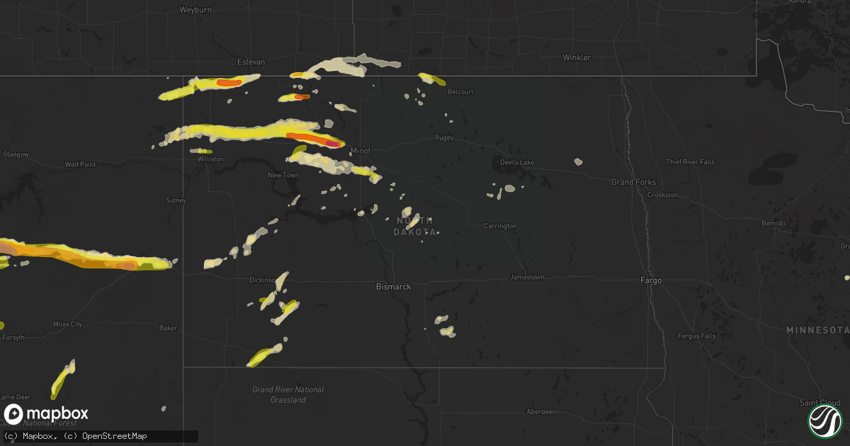
Hail Map in North Dakota on June 9, 2016
Get this storm
June 9 map
$229
one time, instant access
Download today. No call, no setup
Keep the $229
Bought the map and want the full workflow? Apply the entire $229 to a subscription within 7 days. None of it is wasted.
Every map, not just this one
This buys you this map. Subscription and you get every map we run, in the markets you choose from a few cities to whole states to nationwide. Plus real-time alerts the moment a storm fires.
Contact data
Name, contact info, occupancy, even credit band for addresses in the footprint. You go from where it hit to who to call.
Become the source they trust
Unlimited branding weather history reports on demand. You already have the documented answer ready for the property owner, and you are the one who showed up with it.
Property data and RoofTrace estimates
Pull up any address you have got, its value and the exact code rules for that jurisdiction, straight from One Click Code. Then RoofTrace estimates the squares, pitch, and roof value, priced the way you price.
Storm reports in North Dakota
North Dakota
| Date | Description |
|---|---|
| 06/09/20164:26 PM CDT | Reports of tree branches and small trees down. Vinyl siding also removed from the west side of homes. Multiple reports of windows broken from hail and wind. |
| 06/09/20164:26 PM CDT | Passed on via social media |
| 06/09/20164:20 PM CDT | A local report indicates 1.00 inch wind near 5 W CROSBY |
| 06/09/20164:10 PM CDT | 40 mph winds |
| 06/09/20164:05 PM CDT | A local report indicates 1.25 inch wind near 2 E FORTUNA |
| 06/09/20164:00 AM CDT | Two small 4-6 inch diamter trees snapped. Several tree branches and limbs broken down around a farm yard. |
| 06/09/20163:40 AM CDT | Widespread damage in lansford. Roof and east wall of a mobile home torn off. Grain elevator damaged and full grain bins knocked down. Widespread tree damage. Many build |
| 06/09/20163:00 AM CDT | 4 inch limb down in yard. Truck blown off us 2. |
| 06/09/20162:25 AM CDT | A local report indicates 60 MPH wind near TOLNA |
| 06/09/20162:22 AM CDT | Ndawn measurement |
| 06/09/20162:15 AM CDT | Several large 4-6 inch diameter tree branches broken down by the winds. |
| 06/09/20162:15 AM CDT | Some tree branches down... 0.63 inches of rainfall. |
| 06/09/20162:00 AM CDT | A few dime to quarter sized hail along with brief heavy rains and very strong winds. |
| 06/09/20161:55 AM CDT | A local report indicates 61 MPH wind near 1 W CARRINGTON |
| 06/09/20161:32 AM CDT | A local report indicates 62 MPH wind near CATHAY |
| 06/09/201612:59 AM CDT | A local report indicates 79 MPH wind near 1 NE DENHOFF |
| 06/09/201612:35 AM CDT | A local report indicates 60 MPH wind near 2 N ROLLA |
| 06/09/201612:32 AM CDT | Davis weather system measurement |
| 06/08/201611:55 PM CDT | A local report indicates 71 MPH wind near RUGBY |
| 06/08/201611:51 PM CDT | A local report indicates 58 MPH wind near 1 W GARRISON |
| 06/08/201611:20 PM CDT | Quarter size hail reported on the east side of minot. Public report forwarded by kmot-tv |
| 06/08/201611:05 PM CDT | Widespread damage in deering. Shingles off many roofs... Brick chimneys damaged... Multiple trees down and a ten thousand bushel anchored grain bin blown over. |
| 06/08/201610:56 PM CDT | A local report indicates 60 MPH wind near 2 N MINOT |
| 06/08/201610:47 PM CDT | A local report indicates 84 MPH wind near MINOT AIR FORCE BASE |
| 06/08/201610:40 PM CDT | Wind speed estimated. Debris scattered through yard. Time estimated from radar. |
| 06/08/201610:40 PM CDT | Widespread tree damage and shingles taken off roofs. Winds estimated to 75 mph. |
| 06/08/201610:40 PM CDT | Widespread damage in lansford. Roof and east wall of a mobile home torn off. Grain elevator damaged and full grain bins knocked down. Widespread tree damage. Many build |
| 06/08/201610:33 PM CDT | A local report indicates 60 MPH wind near PLAZA |
| 06/08/201610:25 PM CDT | Quarter size hail. |
| 06/08/201610:15 PM CDT | Trees and power lines were downed in tolley. Estimated that one third of the town of tolley was without power following the storm. Time estimated based on radar. |
| 06/08/201610:00 PM CDT | A local report indicates 1.00 inch wind near BLAISDELL |
| 06/08/20169:55 PM CDT | Golfball size hail. Time estimated based on radar. |
| 06/08/20169:40 PM CDT | Two power polls down. |
| 06/08/20169:35 PM CDT | A local report indicates 60 MPH wind near 2 SW STANLEY |
| 06/08/20169:17 PM CDT | A local report indicates 1.00 inch wind near TIOGA |
| 06/08/20169:15 PM CDT | Beach asos reports a wind gust of 53 kts or 61 mph. |
| 06/08/20169:10 PM CDT | Motstly quarter sized hail with some a little bigger... 15-20 mph winds... 0.10-0.15 inches of rain |
| 06/08/20169:06 PM CDT | Nickel size hail accompanied estimated winds of 60 to 70 mph |
| 06/08/20168:55 PM CDT | Intense rain |
| 06/08/20168:05 PM CDT | Public report relayed from kmot-tv |
| 06/08/20167:45 PM CDT | Hail covered the ground to a depth of 1 to 1.5 inches... Winds to 50 mph... And 0.45 inches of rain. |
| 06/08/20167:16 PM CDT | A local report indicates 1.00 inch wind near 13 S DICKINSON |
All States Impacted by Hail Map on June 9, 2016
Cities Impacted by Hail Map on June 9, 2016
- Musselshell, MT
- Roundup, MT
- Winifred, MT
- Ulysses, KS
- Brusett, MT
- Loving, NM
- Bowbells, ND
- Lignite, ND
- Hampshire, IL
- Sycamore, IL
- Genoa, IL
- Satanta, KS
- Killdeer, ND
- Zahl, ND
- Williston, ND
- Muleshoe, TX
- Healy, KS
- Gove, KS
- Stoughton, WI
- Cambridge, WI
- Cottage Grove, WI
- Neihart, MT
- Monarch, MT
- Fort Atkinson, WI
- Mosby, MT
- Winnett, MT
- Sand Springs, MT
- Forest Grove, MT
- Grass Range, MT
- Kintyre, ND
- Dighton, KS
- Westby, MT
- Hereford, TX
- Berthold, ND
- Stanley, ND
- Palermo, ND
- Taylor, ND
- Gladstone, ND
- Richardton, ND
- Denton, MT
- Panhandle, TX
- Reeder, ND
- Hettinger, ND
- Meade, KS
- Delavan, WI
- Elkhorn, WI
- Lordsburg, NM
- Hammond, MT
- Capitol, MT
- Oberlin, KS
- Hobbs, NM
- Seminole, TX
- Plains, KS
- Fort Sumner, NM
- Yeso, NM
- Minot, ND
- Sawyer, ND
- Max, ND
- Douglas, ND
- Bottineau, ND
- Dunseith, ND
- Elida, NM
- Pep, NM
- Rosenberg, TX
- Hereford, AZ
- Elgin, AZ
- Dupree, SD
- Bainville, MT
- Medicine Lake, MT
- Dagmar, MT
- Epping, ND
- Ross, ND
- Froid, MT
- Donnybrook, ND
- Kenmare, ND
- Powers Lake, ND
- Carpio, ND
- Grenora, ND
- Burlington, ND
- Alamo, ND
- White Earth, ND
- Ray, ND
- Des Lacs, ND
- Tioga, ND
- Camp Crook, SD
- Wishek, ND
- Napoleon, ND
- Linton, ND
- Mud Butte, SD
- Jal, NM
- Sunray, TX
- Plaza, ND
- Terry, MT
- Volborg, MT
- Mott, ND
- Regent, ND
- Belt, MT
- Raynesford, MT
- Medora, ND
- Garden City, KS
- Cohagen, MT
- Geyser, MT
- Stanford, MT
- Coffee Creek, MT
- Ignacio, CO
- Dumas, TX
- Friona, TX
- Jordan, MT
- Lindsay, MT
- Glendive, MT
- Wibaux, MT
- Brockway, MT
- Box Elder, MT
- Havre, MT
- Janesville, WI
- Evansville, WI
- Otter, MT
- North Chicago, IL
- Round Lake, IL
- Mundelein, IL
- Great Lakes, IL
- Ingleside, IL
- Lake Bluff, IL
- Libertyville, IL
- Grayslake, IL
- Lake Villa, IL
- Milton, WI
- Whitewater, WI
- Rolette, ND
- Leaf River, IL
- German Valley, IL
- Manning, ND
- Elfrida, AZ
- Stratford, TX
- Scott City, KS
- Newell, SD
- Belle Fourche, SD
- Winnebago, IL
- Byron, IL
- Rockford, IL
- Noonan, ND
- Crosby, ND
- Antelope, MT
- Columbus, ND
- Ambrose, ND
- Plentywood, MT
- Fortuna, ND
- Gruver, TX
- Hugoton, KS
- Davis, IL
- Freeport, IL
- Ridott, IL
- Dakota, IL
- Rock City, IL
- Pecatonica, IL
- Canyon, TX
- Moore, MT
- Decker, MT
- Masterson, TX
- Fairfield, ND
- Buffalo, SD
- Channing, TX
- Lewistown, MT
- Andrews, TX
- Conchas Dam, NM
- Sentinel Butte, ND
- Makoti, ND
- Ryder, ND
- White Sulphur Springs, MT
- Adrian, TX
- Hilger, MT
- Pecos, TX
- Animas, NM
- Englewood, KS
- Sturgis, SD
- Deadwood, SD
- Gildford, MT
- McNeal, AZ
- Meadow, SD
- Two Dot, MT
- Eagle Butte, SD
- Sherwood, ND
- Flaxton, ND
- Wauconda, IL
- Bayard, NM
- Patagonia, AZ
- Nogales, AZ
- Coleharbor, ND
- Buffalo, MT
- Hobson, MT
- Roy, MT
- Fowler, KS
- Custer, MT
- Worden, MT
- Lefor, ND
- Meadowlands, MN
- Mohall, ND
- Sheyenne, ND
- Rogers, NM
- Monticello, WI
- Penrose, CO
- Goodrich, ND
- Kermit, TX
- Powell, WY
- Denver, CO
- Velva, ND
- Parshall, ND
- Lansford, ND
- Oberon, ND
- Mcclusky, ND
- Rio Rico, AZ
- Wright, MN
- Cromwell, MN
- McConnell, IL
- Lena, IL
- Winslow, IL
- Forsyth, MT
- Hysham, MT
- Willcox, AZ
- Deerfield, WI
- Gurnee, IL
- Waukegan, IL
- Butte, ND
- Amidon, ND
- Dickinson, ND
- Moscow, KS
- Sublette, KS
- Tatum, NM
- Crossroads, NM
- Faith, SD
- Pampa, TX
- Johnson, KS
- Silver City, NM
- New Glarus, WI
- Brodhead, WI
- Albany, WI
- Footville, WI
- Hill City, SD
- Reva, SD
- Stillman Valley, IL
- Davis Junction, IL
- Denhoff, ND
- Avalon, WI
- Roy, NM
- Shawmut, MT
- San Simon, AZ
- Spring Grove, IL
- Fox Lake, IL
- Antioch, IL
- Lake Forest, IL
- Gallatin Gateway, MT
- Kremlin, MT
- Chinook, MT
- Garrison, ND
- Roseglen, ND
- Amarillo, TX
- Swatara, MN
- Valparaiso, IN
- Wing, ND
- Lavina, MT
- New Town, ND
- Warwick, ND
- Vega, TX
- Colorado City, CO
- Rye, CO
- Pueblo, CO
- Turtle Lake, ND
- Voltaire, ND
- Pearce, AZ
- Burlington, IL
- Navajo Dam, NM
- Bloomfield, NM
- Big Timber, MT
- Braddock, ND
- Monroe, WI
- Antler, ND
- Willow City, ND
- New England, ND
- Sudan, TX
- Ten Sleep, WY
- Townsend, MT
- Plains, TX
- Darien, WI
- Brooklyn, WI
- Belleville, WI
- Dunn Center, ND
- Floodwood, MN
- Big Sandy, MT
- Boulder, CO
- Solano, NM
- Glen Haven, CO
- Clifton, AZ
- McLaughlin, SD
- Fordville, ND
- Petersburg, ND
- Niagara, ND
- McIntosh, SD
- Tolley, ND
- Portales, NM
- Farwell, TX
- New Rockford, ND
- Brownfield, TX
- Claude, TX
- Hazelton, ND
- Scranton, ND
- Westhope, ND
- Edgerton, WI
- Commerce City, CO
- Pollock, SD
- Saint Onge, SD
- Sun Prairie, WI
- Marshall, WI
- Belfield, ND
- Ruso, ND
- Brookston, MN
- Morton, TX
- Maple, TX
- Pompeys Pillar, MT
- Estes Park, CO
- Causey, NM
- Amistad, NM
- Ralph, SD
- Waconia, MN
- Shakopee, MN
- Chaska, MN
- Chanhassen, MN
- Savage, MN
- Victoria, MN
- Eden Prairie, MN
- Montgomery, MN
- Le Center, MN
- Kilkenny, MN
- Minneapolis, MN
- Saint Paul, MN
- Burnsville, MN
- Albert Lea, MN
- Hollandale, MN
- Austin, MN
- Watertown, MN
- Waverly, MN
- Mayer, MN
- Delano, MN
- Montrose, MN
- Howard Lake, MN
- Winsted, MN
- Holcomb, KS
- Shepherd, MT


