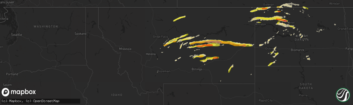
Hail Map in Montana on June 9, 2016
The weather event in Montana on June 9, 2016 includes Hail map. 13 states and 347 cities were impacted and suffered possible damage. The total estimated number of properties impacted is 7,566.
Want more than just the map?
Turn this storm into a full workflow.
- Owner + property data so you know who to knock
- OnDemand branded weather history reports to win the "did we even have hail?" argument
- RoofTrace estimate so reps stop guessing numbers at the door
Bought this map? Upgrade within 7 days and we'll credit the $230. (10-15 min setup call)
Hail
7,566
Estimated number of impacted properties by a 1.00" hail or larger1,608
Estimated number of impacted properties by a 1.75" hail or larger468
Estimated number of impacted properties by a 2.50" hail or largerStorm reports in Montana
Montana
| Date | Description |
|---|---|
| 06/09/20166:51 PM CDT | With wind gusts to 50 mph. Additional info - power out... Roofs and siding damaged... Trees downed. |
| 06/09/20166:25 PM CDT | A local report indicates 2.50 inch wind near 8 N COHAGEN |
| 06/09/20166:18 PM CDT | Winds estimated 55-60 mph with visibility down to 100 yards in heavy rain and wind. |
| 06/09/20166:00 PM CDT | Storm chaser reports baseball sized hail... Which broke several vehicle winshields and windows along highway 200 approximately 20 miles west of jordan. |
| 06/09/20166:00 PM CDT | Report of approximately 70 mph wind gust along highway 200 about 20 miles west of jordan. |
| 06/09/20166:00 PM CDT | A local report indicates 58 MPH wind near 8 SSE WYOLA |
| 06/09/20165:45 PM CDT | A local report indicates 1.00 inch wind near 17 WSW JORDAN |
| 06/09/20165:40 PM CDT | Off duty police chief. Cracked the windshield. Winds estimated to 80 mph. Visibility was near zero with heavy rain... Hail and wind. |
| 06/09/20165:40 PM CDT | Off duty police chief reported large hail... Estimated winds to 80 mph and visibility near zero. |
| 06/09/20165:30 PM CDT | Hail of golfball to tennis ball size wiped out the hay grass and crops in the area. At least four windows busted out in homes. The hail lasted 20 minutes ending at 350 |
| 06/09/20165:14 PM CDT | A local report indicates 2.00 inch wind near 15 NW SAND SPRINGS |
| 06/09/20164:30 PM CDT | A local report indicates 1.75 inch wind near 7 N HILGER |
| 06/09/20164:18 PM CDT | A local report indicates 1.00 inch wind near 10 N TIEGEN |
| 06/09/20164:14 PM CDT | A local report indicates 60 MPH wind near 10 N GRASS RANGE |
| 06/09/20164:14 PM CDT | A local report indicates 1.50 inch wind near 10 N GRASS RANGE |
| 06/09/20164:12 PM CDT | A local report indicates 1.00 inch wind near 11 N GRASS RANGE |
| 06/09/20164:10 PM CDT | Estimated quarter-sized hail. Smaller hail covered ground. Nearly calm wind. |
| 06/09/20164:00 PM CDT | A local report indicates 1.75 inch wind near 12 NNE FORESTGROVE |
| 06/09/20163:40 PM CDT | A local report indicates 1.25 inch wind near COFFEE CREEK |
| 06/09/20163:20 PM CDT | A local report indicates 60 MPH wind near 8 NE ANTELOPE |
| 06/09/20163:00 PM CDT | Estimated quarter to about ping pong size hail...near beaver creek park. |
| 06/09/20163:00 PM CDT | A local report indicates 1.25 inch wind near BOX ELDER |
| 06/09/20162:45 PM CDT | Half-dollar size hail with 0.48 inches rainfall. Smaller hail covered ground |
| 06/09/20162:30 PM CDT | A local report indicates 1.75 inch wind near 7 N HILGER |
| 06/09/20162:30 PM CDT | Hail around half dollar size. Hail damage to vehicles... Resulting in dents and broken windows. |
| 06/09/20162:30 PM CDT | Delayed report from june 9. |
| 06/08/201610:04 PM CDT | Some siding blown off of house. |
| 06/08/20169:43 PM CDT | A local report indicates 70 MPH wind near 1 SSE BAKER |
| 06/08/20169:43 PM CDT | A local report indicates 74 MPH wind near 10 NNE MCCLOUD |
| 06/08/20169:40 PM CDT | A local report indicates 70 MPH wind near 4 SE KNOWLTON |
| 06/08/20169:30 PM CDT | A local report indicates 67 MPH wind near 2 NW ROCK SPRINGS |
| 06/08/20169:25 PM CDT | A local report indicates 70 MPH wind near 30 NW TERRY |
| 06/08/20168:34 PM CDT | A local report indicates 1.00 inch wind near WSW GLENDIVE |
| 06/08/20168:30 PM CDT | A local report indicates 1.25 inch wind near 3 S GLENDIVE |
| 06/08/20168:25 PM CDT | A local report indicates 1.00 inch wind near WSW GLENDIVE |
| 06/08/20168:25 PM CDT | A local report indicates 2.75 inch wind near 10 SW GLENDIVE |
| 06/08/20168:20 PM CDT | A local report indicates 58 MPH wind near 20 N BROADUS |
| 06/08/20168:08 PM CDT | Knocked trees down. |
| 06/08/20168:06 PM CDT | Tree down on property in the town of hysham. |
| 06/08/20168:05 PM CDT | A local report indicates 63 MPH wind near 9 NW COALWOOD |
| 06/08/20168:00 PM CDT | A local report indicates 1.75 inch wind near 13 SSW LINDSAY |
| 06/08/20167:55 PM CDT | Trained spotter reports hail ranging from quarter to golf ball size between 645 pm and 655 pm |
| 06/08/20167:55 PM CDT | A local report indicates 1.00 inch wind near 9 SE EDWARDS |
| 06/08/20167:35 PM CDT | A local report indicates 1.25 inch wind near 15 N POMPEYS PILLAR |
| 06/08/20167:25 PM CDT | A local report indicates 58 MPH wind near 3 NW BILLINGS |
| 06/08/20167:22 PM CDT | A local report indicates 1.75 inch wind near 5 W DELPHIA |
| 06/08/20167:20 PM CDT | Estimate made by an nws/spc forecaster. |
| 06/08/20167:20 PM CDT | A local report indicates 1.50 inch wind near 1 E MOSBY |
| 06/08/20167:15 PM CDT | A local report indicates 1.00 inch wind near 10 E WINNETT |
| 06/08/20167:13 PM CDT | A local report indicates 1.00 inch wind near 1 N ROUNDUP |
| 06/08/20167:06 PM CDT | A local report indicates 1.00 inch wind near ROUNDUP |
| 06/08/20167:06 PM CDT | A local report indicates 1.00 inch wind near 1 NNW ROUNDUP |
| 06/08/20167:00 PM CDT | Off duty nws employee storm chasing reported 1 to 1.75 hail and 60 mph wind. |
| 06/08/20167:00 PM CDT | Straight line wind knocked over a couple of 10000 bushel grain bins and damaged some overhead steel doors on a quonset style storage building. |
All States Impacted by Hail Map on June 9, 2016
Cities Impacted by Hail Map on June 9, 2016
- Musselshell, MT
- Roundup, MT
- Winifred, MT
- Ulysses, KS
- Brusett, MT
- Loving, NM
- Bowbells, ND
- Lignite, ND
- Hampshire, IL
- Sycamore, IL
- Genoa, IL
- Satanta, KS
- Killdeer, ND
- Zahl, ND
- Williston, ND
- Muleshoe, TX
- Healy, KS
- Gove, KS
- Stoughton, WI
- Cambridge, WI
- Cottage Grove, WI
- Neihart, MT
- Monarch, MT
- Fort Atkinson, WI
- Mosby, MT
- Winnett, MT
- Sand Springs, MT
- Forest Grove, MT
- Grass Range, MT
- Kintyre, ND
- Dighton, KS
- Westby, MT
- Hereford, TX
- Berthold, ND
- Stanley, ND
- Palermo, ND
- Taylor, ND
- Gladstone, ND
- Richardton, ND
- Denton, MT
- Panhandle, TX
- Reeder, ND
- Hettinger, ND
- Meade, KS
- Delavan, WI
- Elkhorn, WI
- Lordsburg, NM
- Hammond, MT
- Capitol, MT
- Oberlin, KS
- Hobbs, NM
- Seminole, TX
- Plains, KS
- Fort Sumner, NM
- Yeso, NM
- Minot, ND
- Sawyer, ND
- Max, ND
- Douglas, ND
- Bottineau, ND
- Dunseith, ND
- Elida, NM
- Pep, NM
- Rosenberg, TX
- Hereford, AZ
- Elgin, AZ
- Dupree, SD
- Bainville, MT
- Medicine Lake, MT
- Dagmar, MT
- Epping, ND
- Ross, ND
- Froid, MT
- Donnybrook, ND
- Kenmare, ND
- Powers Lake, ND
- Carpio, ND
- Grenora, ND
- Burlington, ND
- Alamo, ND
- White Earth, ND
- Ray, ND
- Des Lacs, ND
- Tioga, ND
- Camp Crook, SD
- Wishek, ND
- Napoleon, ND
- Linton, ND
- Mud Butte, SD
- Jal, NM
- Sunray, TX
- Plaza, ND
- Terry, MT
- Volborg, MT
- Mott, ND
- Regent, ND
- Belt, MT
- Raynesford, MT
- Medora, ND
- Garden City, KS
- Cohagen, MT
- Geyser, MT
- Stanford, MT
- Coffee Creek, MT
- Ignacio, CO
- Dumas, TX
- Friona, TX
- Jordan, MT
- Lindsay, MT
- Glendive, MT
- Wibaux, MT
- Brockway, MT
- Box Elder, MT
- Havre, MT
- Janesville, WI
- Evansville, WI
- Otter, MT
- North Chicago, IL
- Round Lake, IL
- Mundelein, IL
- Great Lakes, IL
- Ingleside, IL
- Lake Bluff, IL
- Libertyville, IL
- Grayslake, IL
- Lake Villa, IL
- Milton, WI
- Whitewater, WI
- Rolette, ND
- Leaf River, IL
- German Valley, IL
- Manning, ND
- Elfrida, AZ
- Stratford, TX
- Scott City, KS
- Newell, SD
- Belle Fourche, SD
- Winnebago, IL
- Byron, IL
- Rockford, IL
- Noonan, ND
- Crosby, ND
- Antelope, MT
- Columbus, ND
- Ambrose, ND
- Plentywood, MT
- Fortuna, ND
- Gruver, TX
- Hugoton, KS
- Davis, IL
- Freeport, IL
- Ridott, IL
- Dakota, IL
- Rock City, IL
- Pecatonica, IL
- Canyon, TX
- Moore, MT
- Decker, MT
- Masterson, TX
- Fairfield, ND
- Buffalo, SD
- Channing, TX
- Lewistown, MT
- Andrews, TX
- Conchas Dam, NM
- Sentinel Butte, ND
- Makoti, ND
- Ryder, ND
- White Sulphur Springs, MT
- Adrian, TX
- Hilger, MT
- Pecos, TX
- Animas, NM
- Englewood, KS
- Sturgis, SD
- Deadwood, SD
- Gildford, MT
- McNeal, AZ
- Meadow, SD
- Two Dot, MT
- Eagle Butte, SD
- Sherwood, ND
- Flaxton, ND
- Wauconda, IL
- Bayard, NM
- Patagonia, AZ
- Nogales, AZ
- Coleharbor, ND
- Buffalo, MT
- Hobson, MT
- Roy, MT
- Fowler, KS
- Custer, MT
- Worden, MT
- Lefor, ND
- Meadowlands, MN
- Mohall, ND
- Sheyenne, ND
- Rogers, NM
- Monticello, WI
- Penrose, CO
- Goodrich, ND
- Kermit, TX
- Powell, WY
- Denver, CO
- Velva, ND
- Parshall, ND
- Lansford, ND
- Oberon, ND
- Mcclusky, ND
- Rio Rico, AZ
- Wright, MN
- Cromwell, MN
- McConnell, IL
- Lena, IL
- Winslow, IL
- Forsyth, MT
- Hysham, MT
- Willcox, AZ
- Deerfield, WI
- Gurnee, IL
- Waukegan, IL
- Butte, ND
- Amidon, ND
- Dickinson, ND
- Moscow, KS
- Sublette, KS
- Tatum, NM
- Crossroads, NM
- Faith, SD
- Pampa, TX
- Johnson, KS
- Silver City, NM
- New Glarus, WI
- Brodhead, WI
- Albany, WI
- Footville, WI
- Hill City, SD
- Reva, SD
- Stillman Valley, IL
- Davis Junction, IL
- Denhoff, ND
- Avalon, WI
- Roy, NM
- Shawmut, MT
- San Simon, AZ
- Spring Grove, IL
- Fox Lake, IL
- Antioch, IL
- Lake Forest, IL
- Gallatin Gateway, MT
- Kremlin, MT
- Chinook, MT
- Garrison, ND
- Roseglen, ND
- Amarillo, TX
- Swatara, MN
- Valparaiso, IN
- Wing, ND
- Lavina, MT
- New Town, ND
- Warwick, ND
- Vega, TX
- Colorado City, CO
- Rye, CO
- Pueblo, CO
- Turtle Lake, ND
- Voltaire, ND
- Pearce, AZ
- Burlington, IL
- Navajo Dam, NM
- Bloomfield, NM
- Big Timber, MT
- Braddock, ND
- Monroe, WI
- Antler, ND
- Willow City, ND
- New England, ND
- Sudan, TX
- Ten Sleep, WY
- Townsend, MT
- Plains, TX
- Darien, WI
- Brooklyn, WI
- Belleville, WI
- Dunn Center, ND
- Floodwood, MN
- Big Sandy, MT
- Boulder, CO
- Solano, NM
- Glen Haven, CO
- Clifton, AZ
- McLaughlin, SD
- Fordville, ND
- Petersburg, ND
- Niagara, ND
- McIntosh, SD
- Tolley, ND
- Portales, NM
- Farwell, TX
- New Rockford, ND
- Brownfield, TX
- Claude, TX
- Hazelton, ND
- Scranton, ND
- Westhope, ND
- Edgerton, WI
- Commerce City, CO
- Pollock, SD
- Saint Onge, SD
- Sun Prairie, WI
- Marshall, WI
- Belfield, ND
- Ruso, ND
- Brookston, MN
- Morton, TX
- Maple, TX
- Pompeys Pillar, MT
- Estes Park, CO
- Causey, NM
- Amistad, NM
- Ralph, SD
- Waconia, MN
- Shakopee, MN
- Chaska, MN
- Chanhassen, MN
- Savage, MN
- Victoria, MN
- Eden Prairie, MN
- Montgomery, MN
- Le Center, MN
- Kilkenny, MN
- Minneapolis, MN
- Saint Paul, MN
- Burnsville, MN
- Albert Lea, MN
- Hollandale, MN
- Austin, MN
- Watertown, MN
- Waverly, MN
- Mayer, MN
- Delano, MN
- Montrose, MN
- Howard Lake, MN
- Winsted, MN
- Holcomb, KS
- Shepherd, MT


